 English
 Spanish
 French
 Chinese
 Russian
 Portuguese
 Última Activación
Charter activations
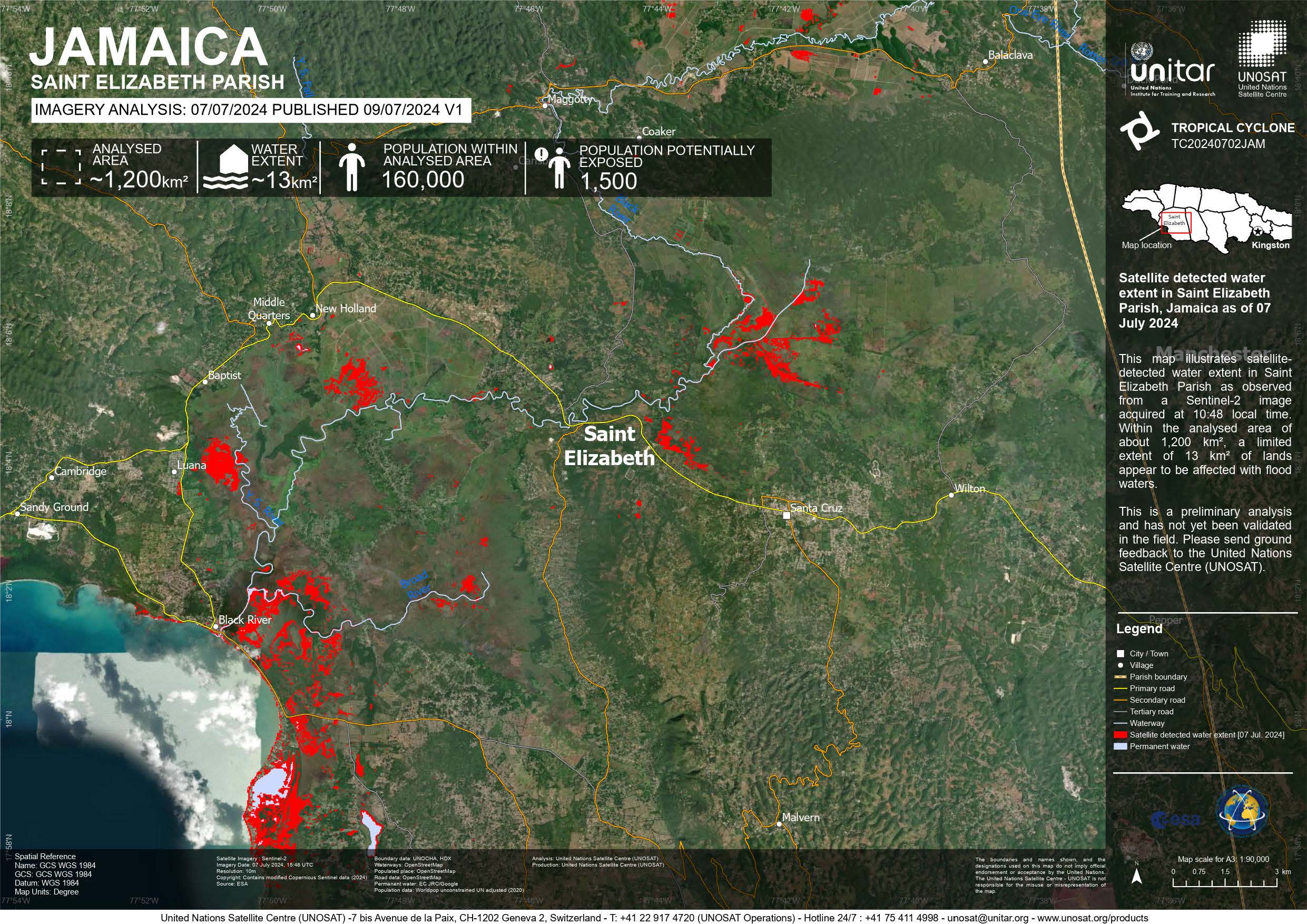
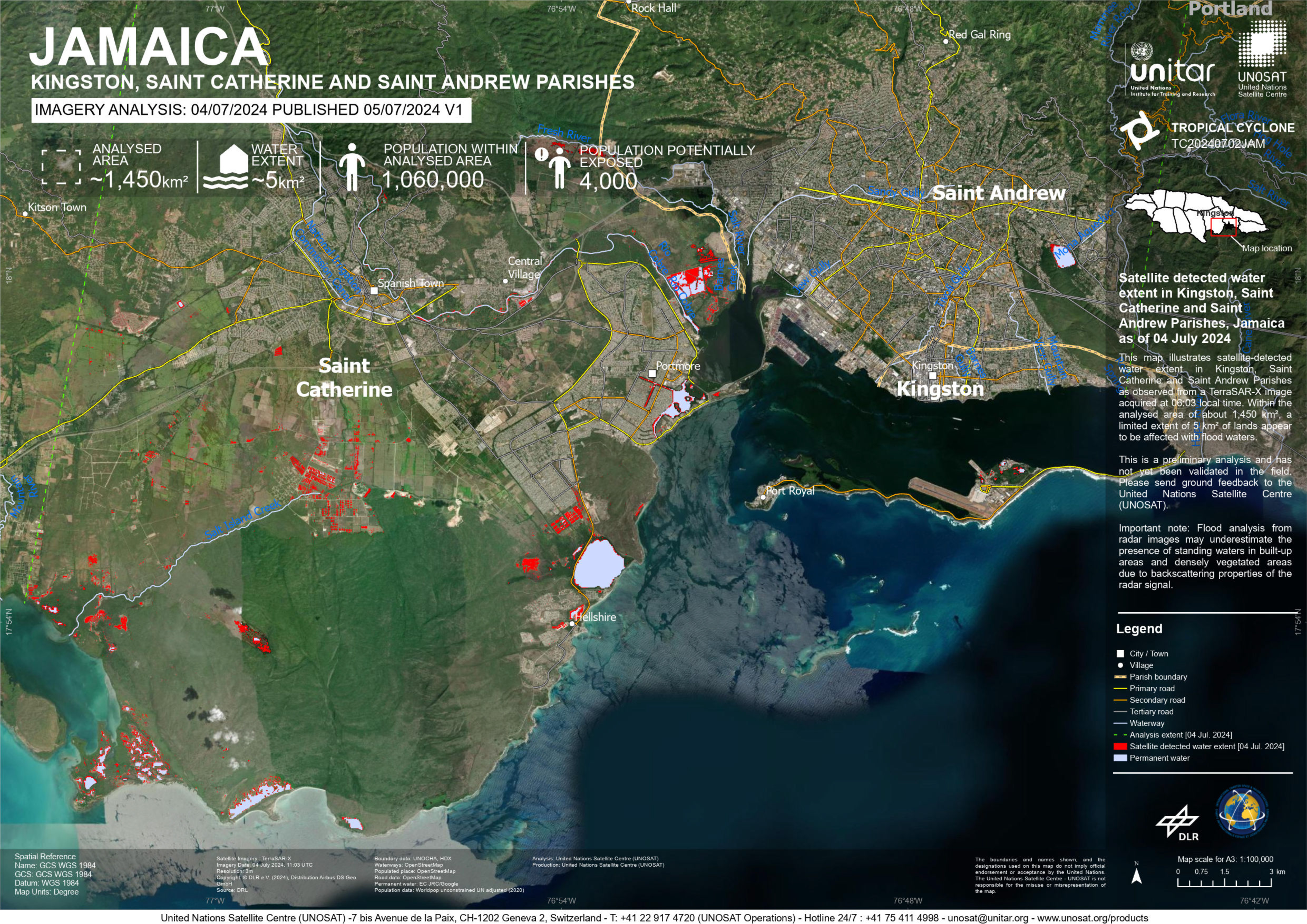
Hurricane Beryl in Jamaica
Hurricane Beryl hit Jamaica on the 3 July bring heavy winds and rainfall. After having battered islands in the eastern Caribbean - killing at least seven people. The storm brought life-threatening winds of up to 130 mph (215 km/h) on to Jamaica's southern coast.
Hurricane Beryl became the earliest hurricane on record to develop into a category four storm, meaning its winds and sea surges were catastrophic, as warming oceans fuelled destruction across the south-eastern Caribbean.Floodwater poured down streets, while roofs were ripped off by the wind. Parts of Jamaica experienced disruption to power and electricity supplies. So far, it has been confirmed that one person has died after a tree fell on their home.
The storm has now weakened to category 2 and has moved on to southern Mexico.
Related Resources:
UNOSAT web map tracking path of Hurricane Beryl towards Jamaica
| Type of Event: | Flood |
| Location of Event: | Jamaica |
| Date of Charter Activation: | 2024-07-02 |
| Time of Charter Activation: | 22:45 |
| Time zone of Charter Activation: | UTC+02:00 |
| Charter Requestor: | UNITAR on behalf of UNEP/OCHA Joint Environment Unit - Emergency Response Section |
| Activation ID: | 893 |
| Project Management: | Teodoro Hunger (UNITAR/UNOSAT) |
| act-value-adders: | NOAA VA (NOAA) |
Products
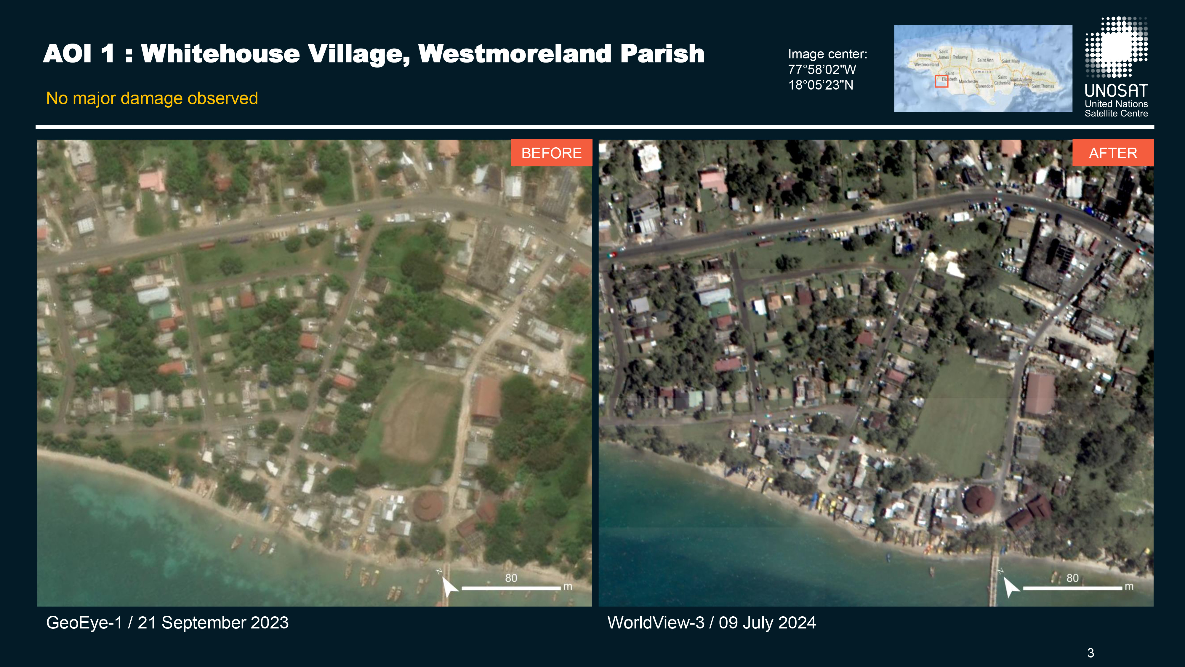
Preliminary satellite-derived damage assessment - Westmoreland, Saint Elizabeth & Manchester Parishes, Jamaica
Download full report
Copyright: © (2024) DigitalGlobe, Inc., Longmont CO USA 80503. DigitalGlobe and the DigitalGlobe logos are trademarks of DigitalGlobe, Inc. The use and/or dissemination of this data and/or of any product in any way derived there from are restricted. Unauthorized use and/or dissemination is prohibited.
Map produced by UNITAR / UNOSAT
Information about the Product
Acquired: 09/07/2024 and 12/07/2024
Source: WorldView-3
Category: Reference Map
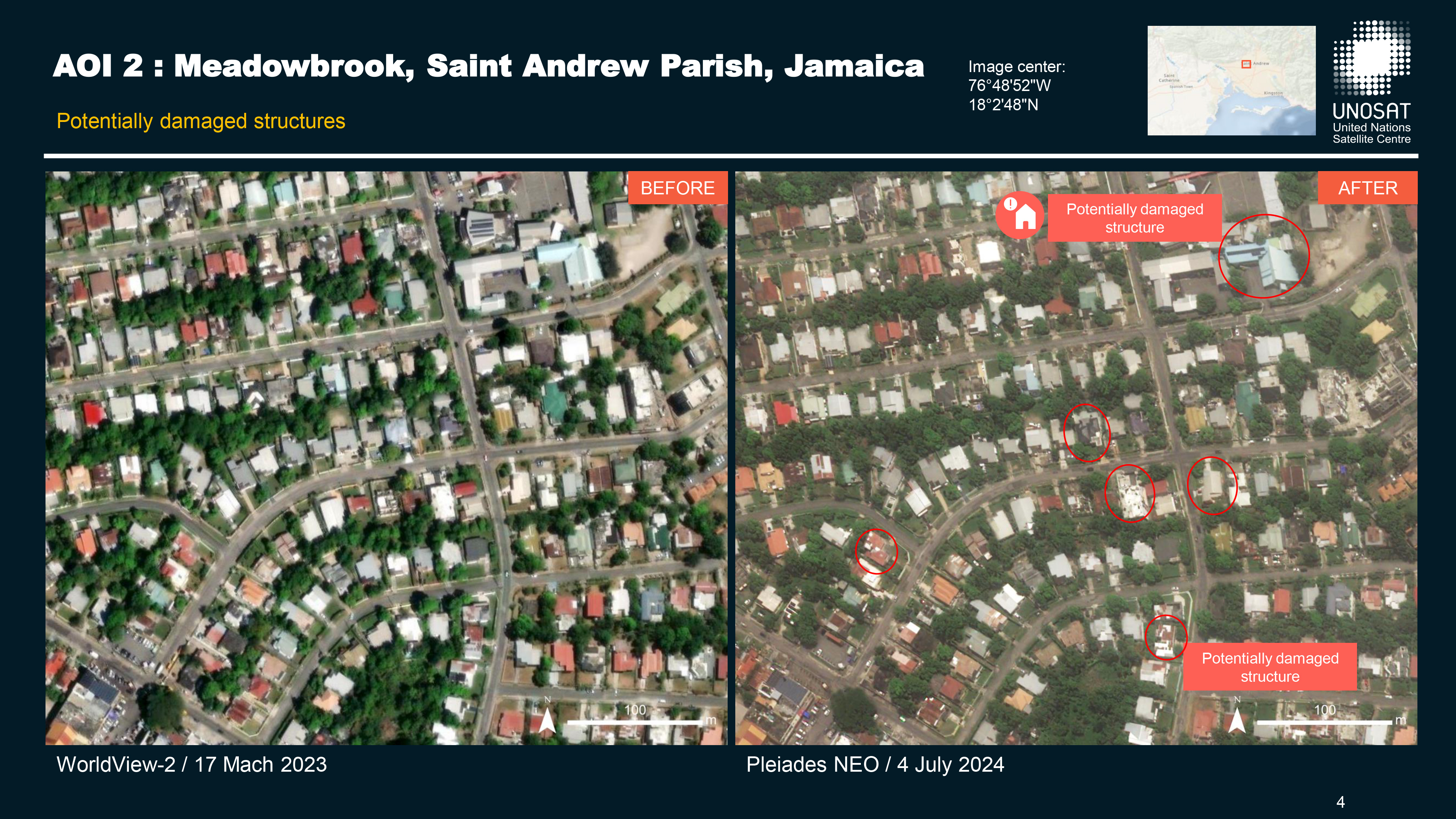
Preliminary satellite-derived damage assessment, Kingston, Jamaica
Download full report
Copyright: Includes Pleiades Neo material © Airbus DS (2024)
Map produced by UNITAR / UNOSAT
Information about the Product
Acquired: 04/07/2024
Source: Pleiades Neo
Category: Reference Map
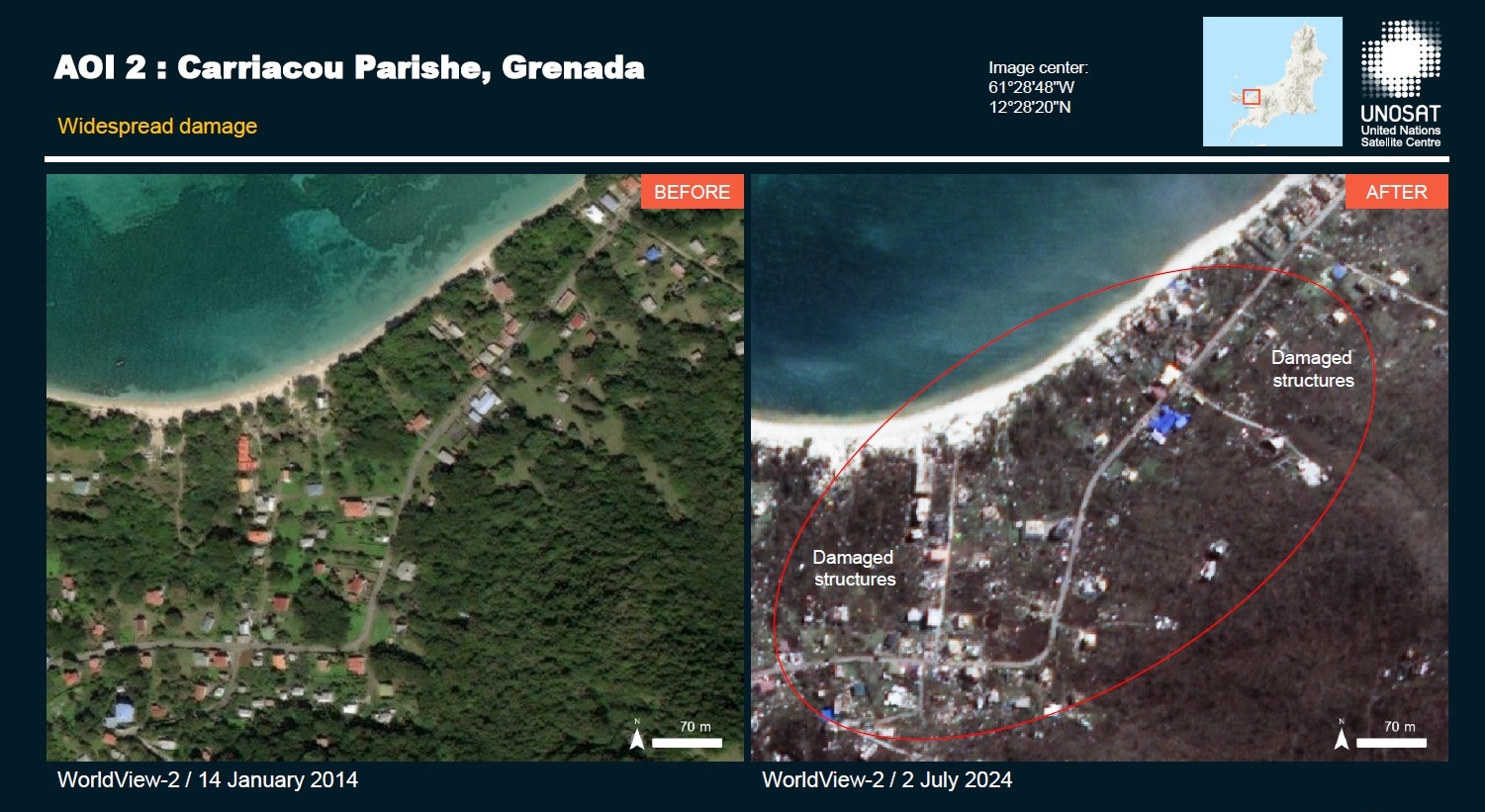
Perliminary satellite-derived damage assessment - Carriacou, Grenada
Download the full report
Copyright: © (2024) DigitalGlobe, Inc., Longmont CO USA 80503. DigitalGlobe and the DigitalGlobe logos are trademarks of DigitalGlobe, Inc. The use and/or dissemination of this data and/or of any product in any way derived there from are restricted. Unauthorized use and/or dissemination is prohibited.
Report produced by UNITAR / UNOSAT
Information about the Product
Acquired: 02/07/2024
Source: WorldView-2
Category: Reference Map
 Back to the full activation archive

