 English
 Spanish
 French
 Chinese
 Russian
 Portuguese
 Последняя Активация
Charter activations
Flood in Sudan
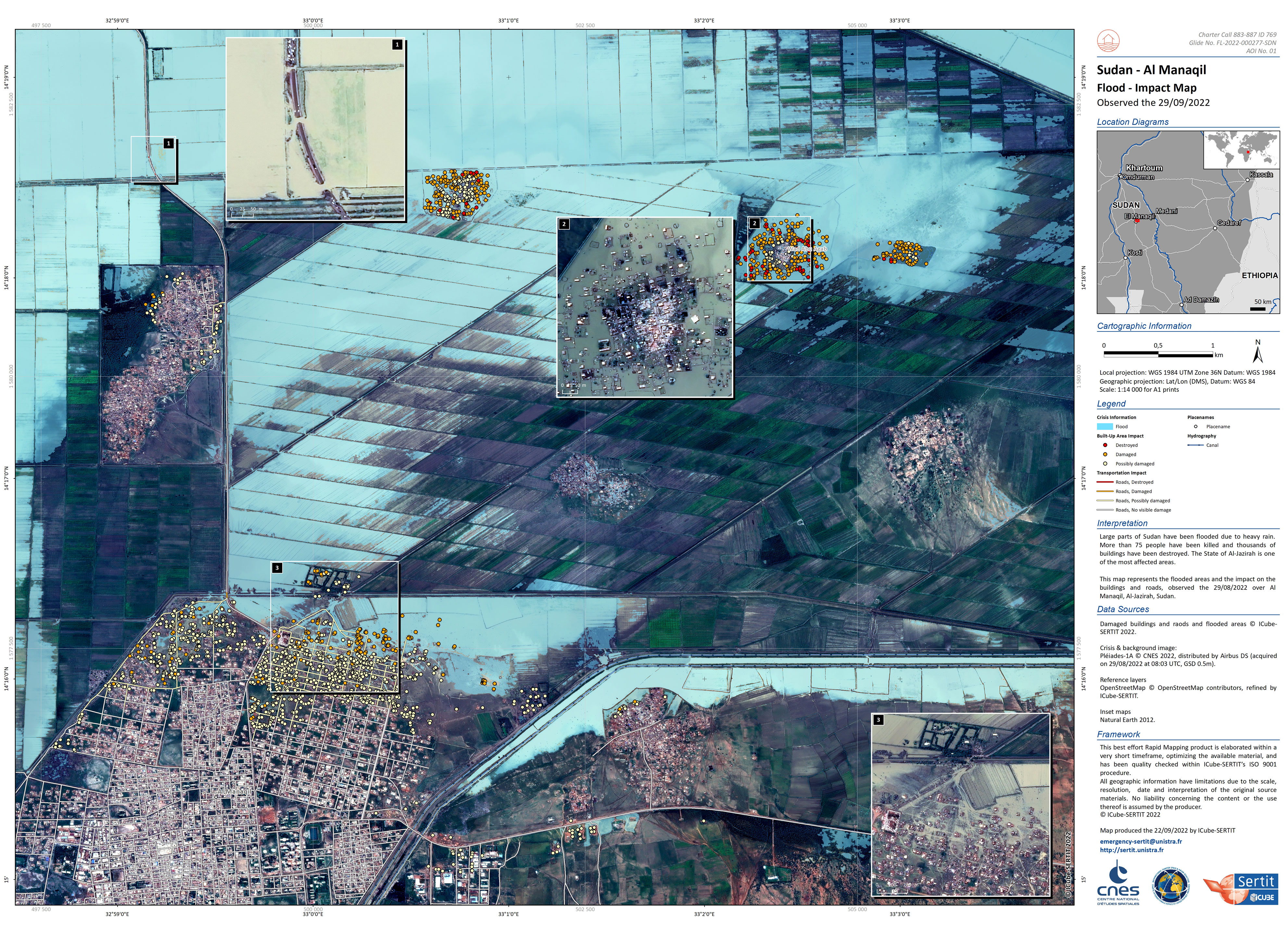
Large parts of Sudan have been flooded due to heavy rain. More than 75 people have been killed and thousands of buildings have been destroyed. Most affected areas include Al-Jazirah, North Kordofan, South Kordofan, South Darfur and the river Nile.
| Тип события: | Floods |
| Место события: | Sudan |
| Date of Charter Activation: | 2022-08-21 |
| Время активации Хартии: | 10:02 |
| TЧасовой пояс в районе активации Хартии: | UTC+02:00 |
| Запрос на активацию поступил от: | Ministry of Agriculture and Natural Resources in Sudan |
| Номер активации: | 769 |
| Менеждер проекта от: | UNITAR/UNOSAT |
Products
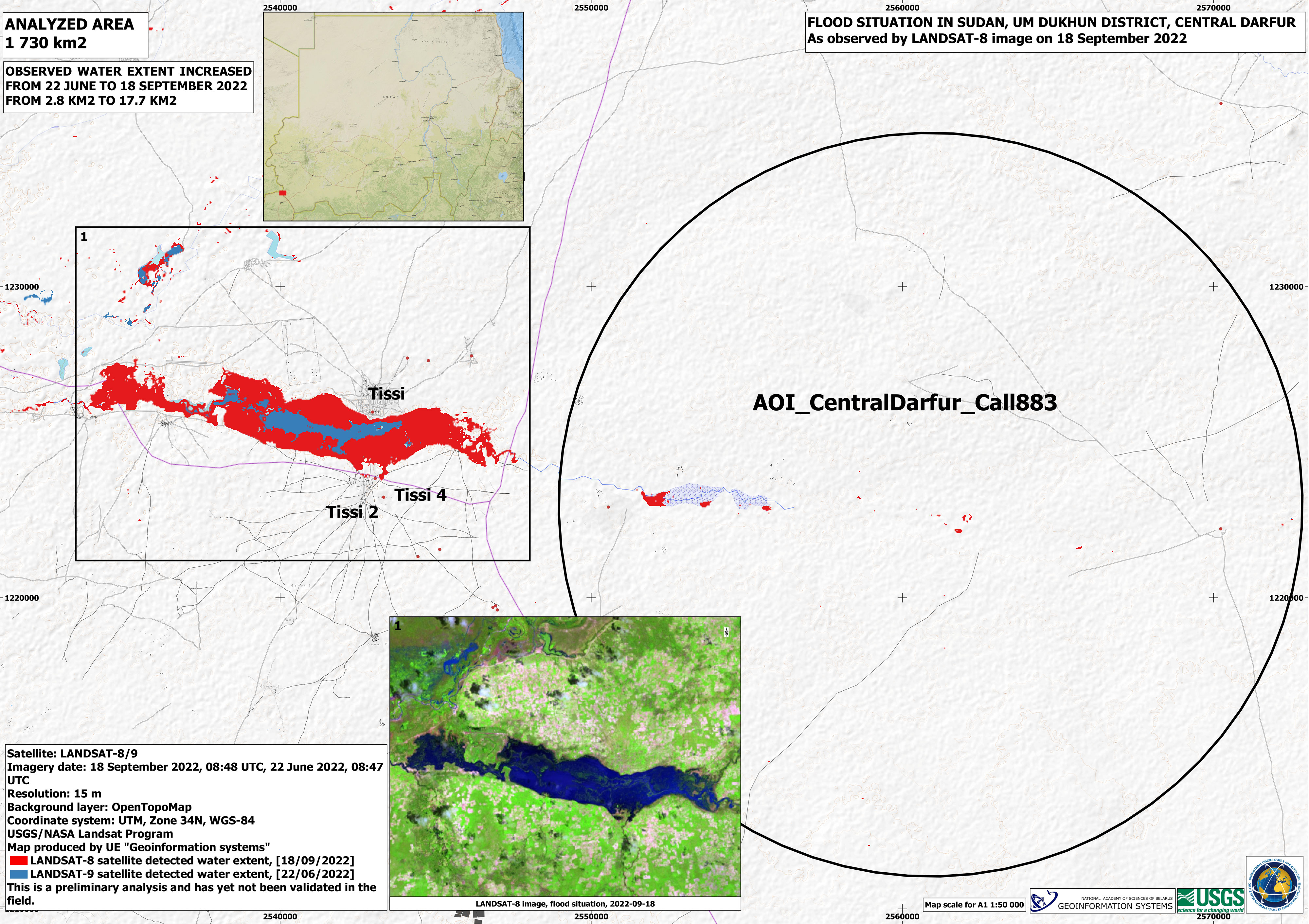
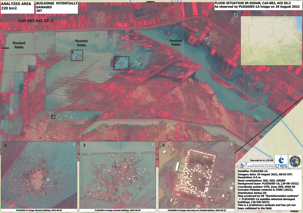
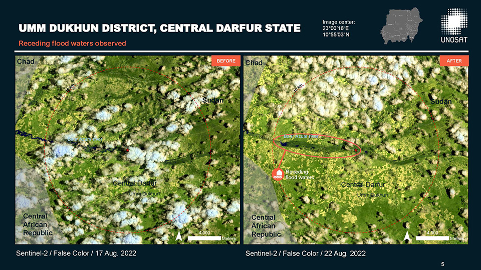
Flood situation in Sudan, Umm Dukhun district, central Darfur
Авторские права: Landsat data and products © NASA/USGS (2022) - All Rights Reserved
Map produced by UE "Geoinformation systems"
Information about the Product
Получено: Landsat 8: 18/09/2022
Landsat 9: 22/06/2022
Источник: Landsat 8 / Landsat 9
Категория: Reference Map

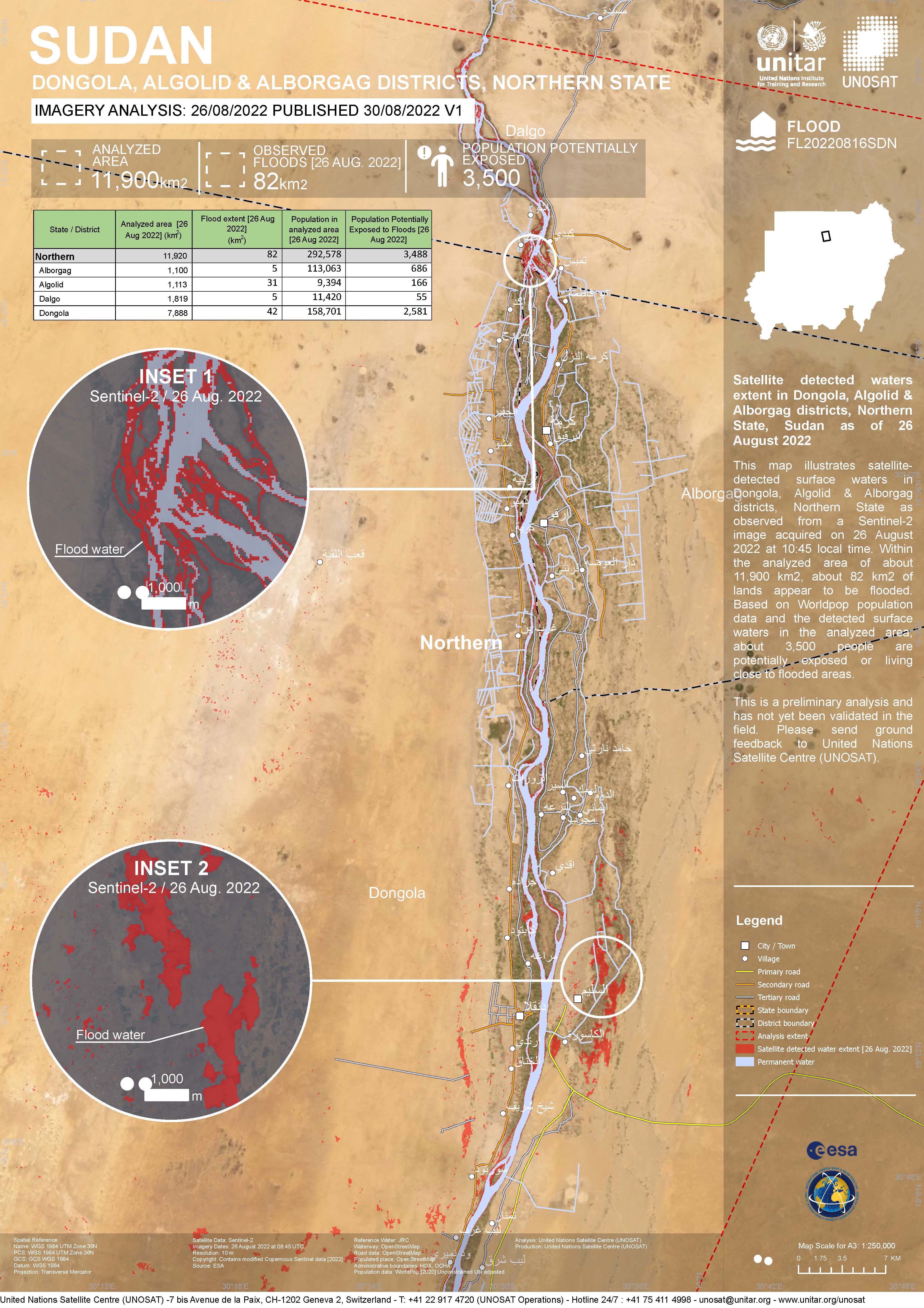
Flood situation in Dongola, Sudan
Авторские права: WorldView-3 © (2022) DigitalGlobe, Inc., Longmont CO USA 80503. DigitalGlobe and the DigitalGlobe logos are trademarks of DigitalGlobe, Inc. The use and/or dissemination of this data and/or of any product in any way derived there from are restricted. Unauthorized use and/or dissemination is prohibited.
Landsat data and products © NASA/USGS (2022) - All Rights Reserved
Map produced by UE GeoInformation Systems
Information about the Product
Получено: WorldView-3: 14/09/2022
Landsat 9: 29/08/2022, 14/09/2022
Источник: WorldView-3, Landsat 9
Категория: Delineation Monitoring Maps
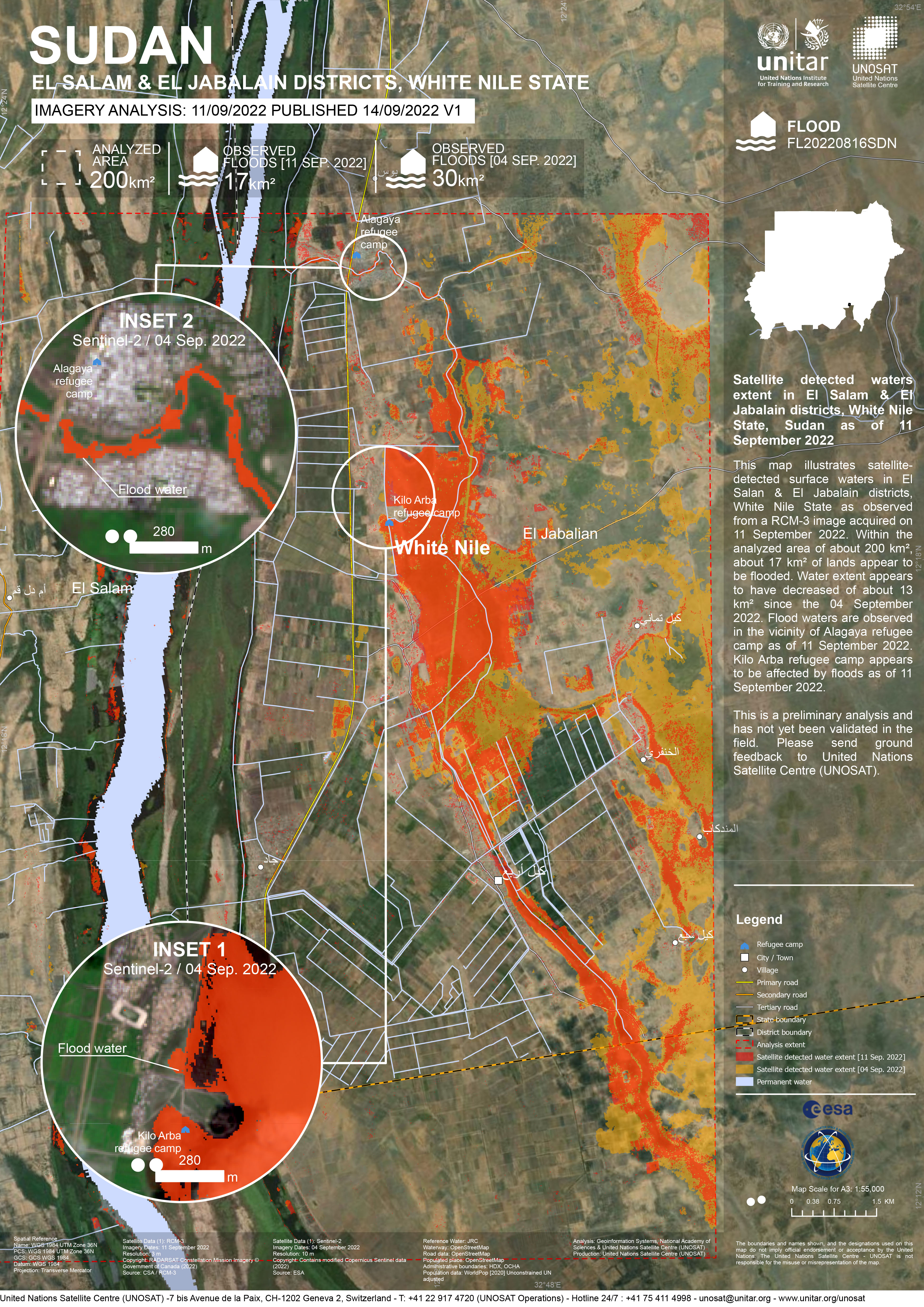
Satellite detected waters extent in El Salam & El Jabalain districts, White Nile State, Sudan
Авторские права: RADARSAT Constellation Mission Imagery © Government of Canada (2022)
Map produced by United Nations Satellite Centre (UNOSAT)
Information about the Product
Получено: 11/09/2022
Источник: RCM
Категория: Delineation Map

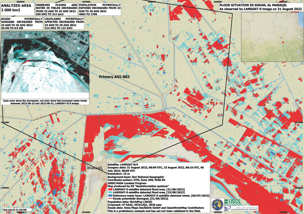
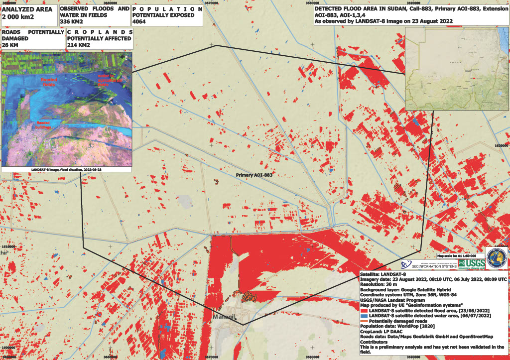
Flood situation in Sudan, Al Manaqil
Авторские права: VRSS-2 © ABAE (2022). All Rights Reserved
Landsat 9 © Landsat data and products © NASA/USGS (2022) - All Rights Reserved
Map produced by UE Geoinformation Systems
Information about the Product
Получено: VRSS-2: 06/09/2022
Landsat 9: 31/08/2022
Источник: VRSS-2 / Landsat 9
Категория: Delineation Monitoring Maps
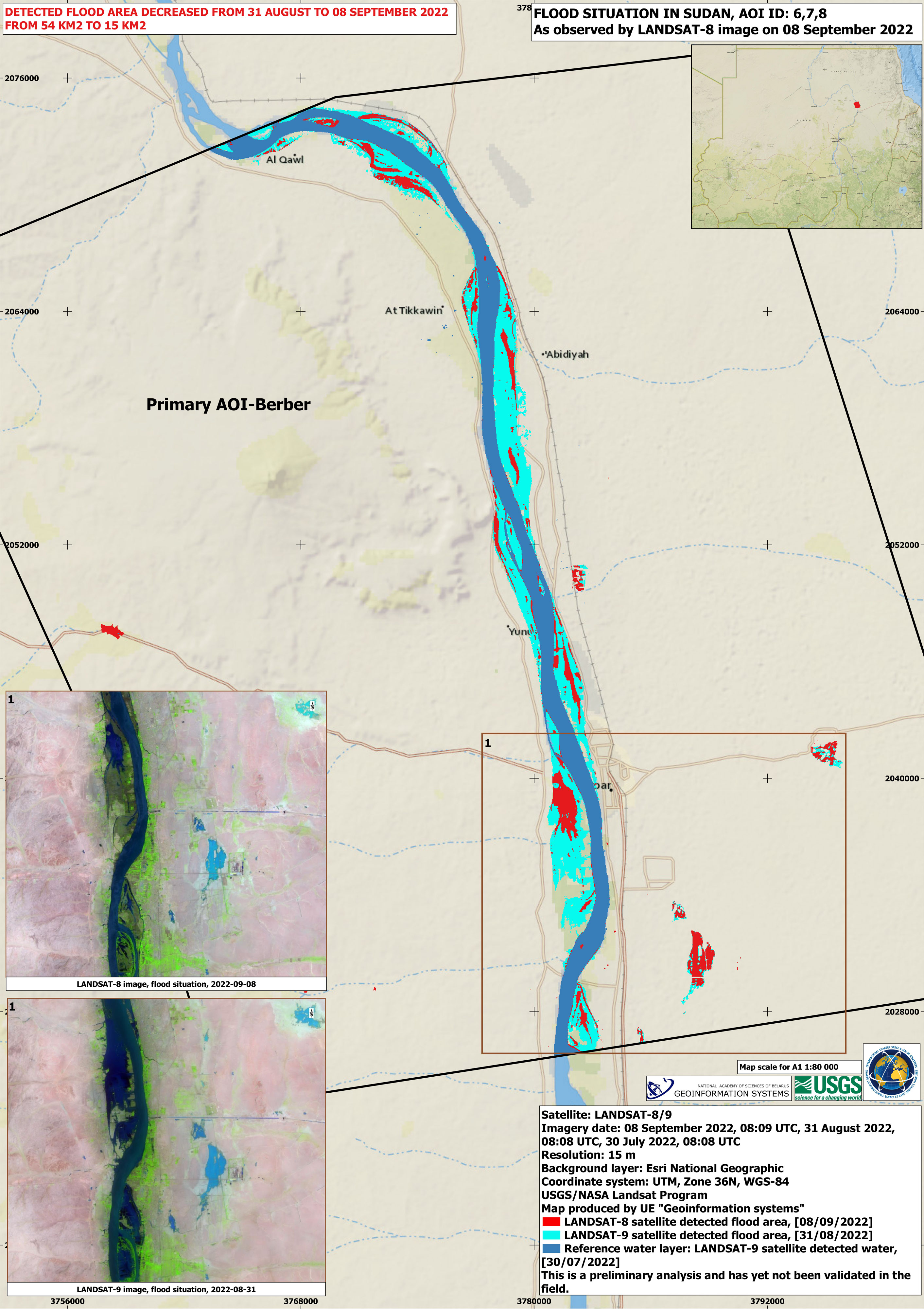
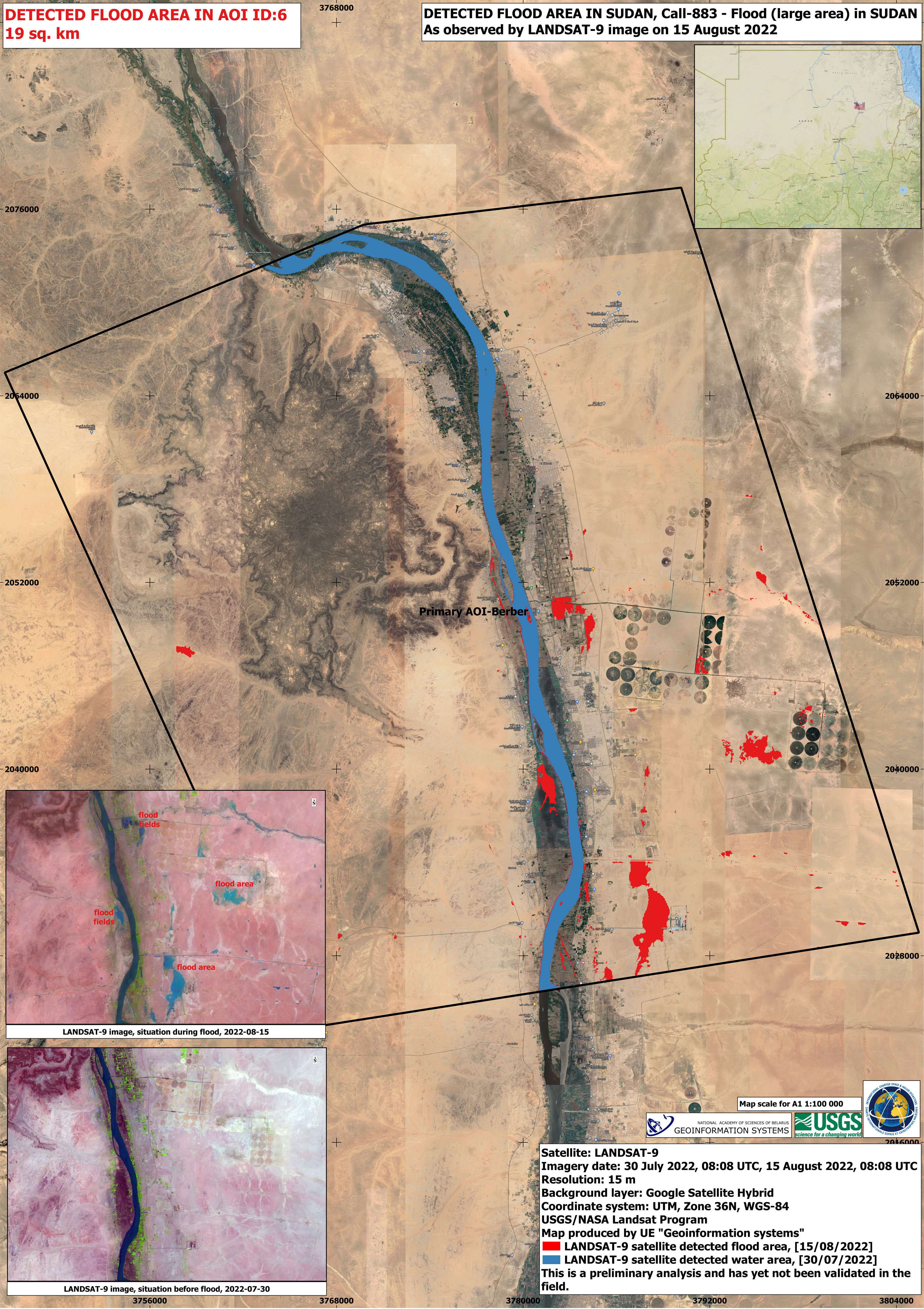
Flood situation in Sudan
Авторские права: Landsat data and products © NASA/USGS (2022) - All Rights Reserved
Map produced by UE "Geoinformation systems"
Information about the Product
Получено: Landsat 9: 30/07/2022, 31/08/2022
Landsat 8: 08/09/2022
Источник: Landsat 9 / Landsat 8
Категория: Delineation Monitoring Maps

Flood in Sudan
Авторские права: Contains modified Copernicus Sentinel data (2022)
RADARSAT Constellation Mission Imagery © Government of Canada
Map produced by UE "Geoinformation systems"
Information about the Product
Получено: Sentinel-2: 04/09/2022, 06/07/2022
RCM: 11/09/2022
Источник: Sentinel-2 / RCM
Категория: Delineation Monitoring Maps
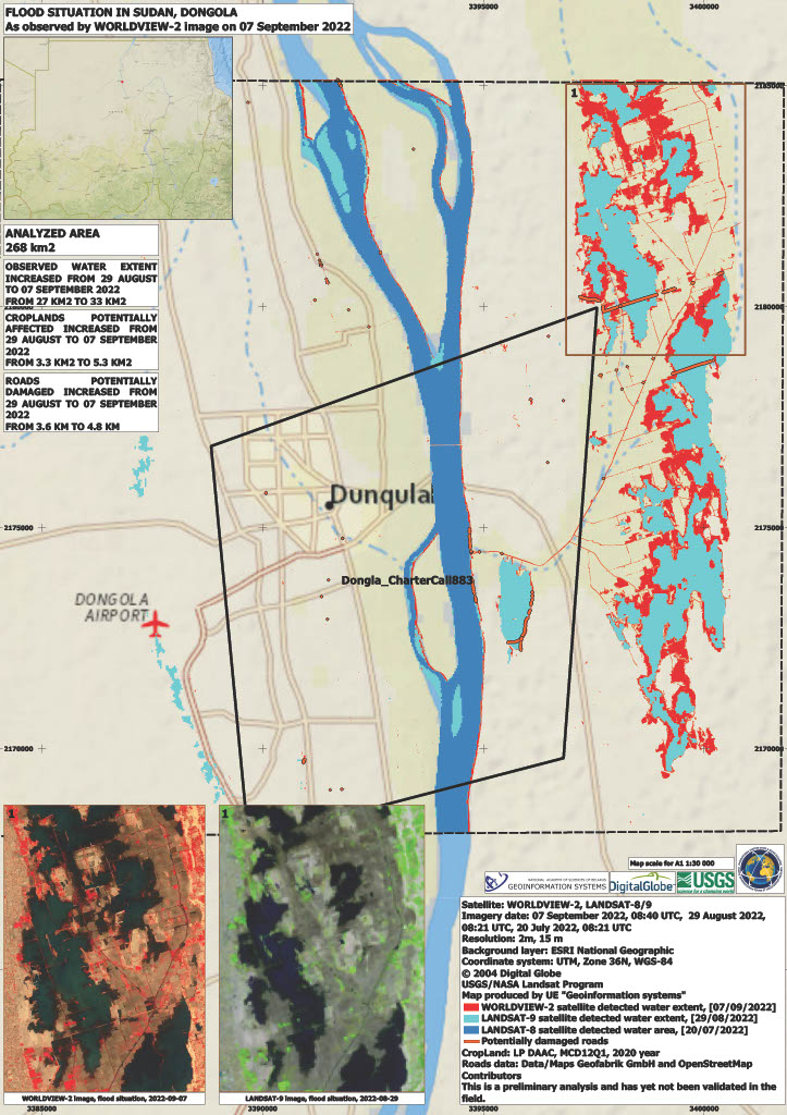
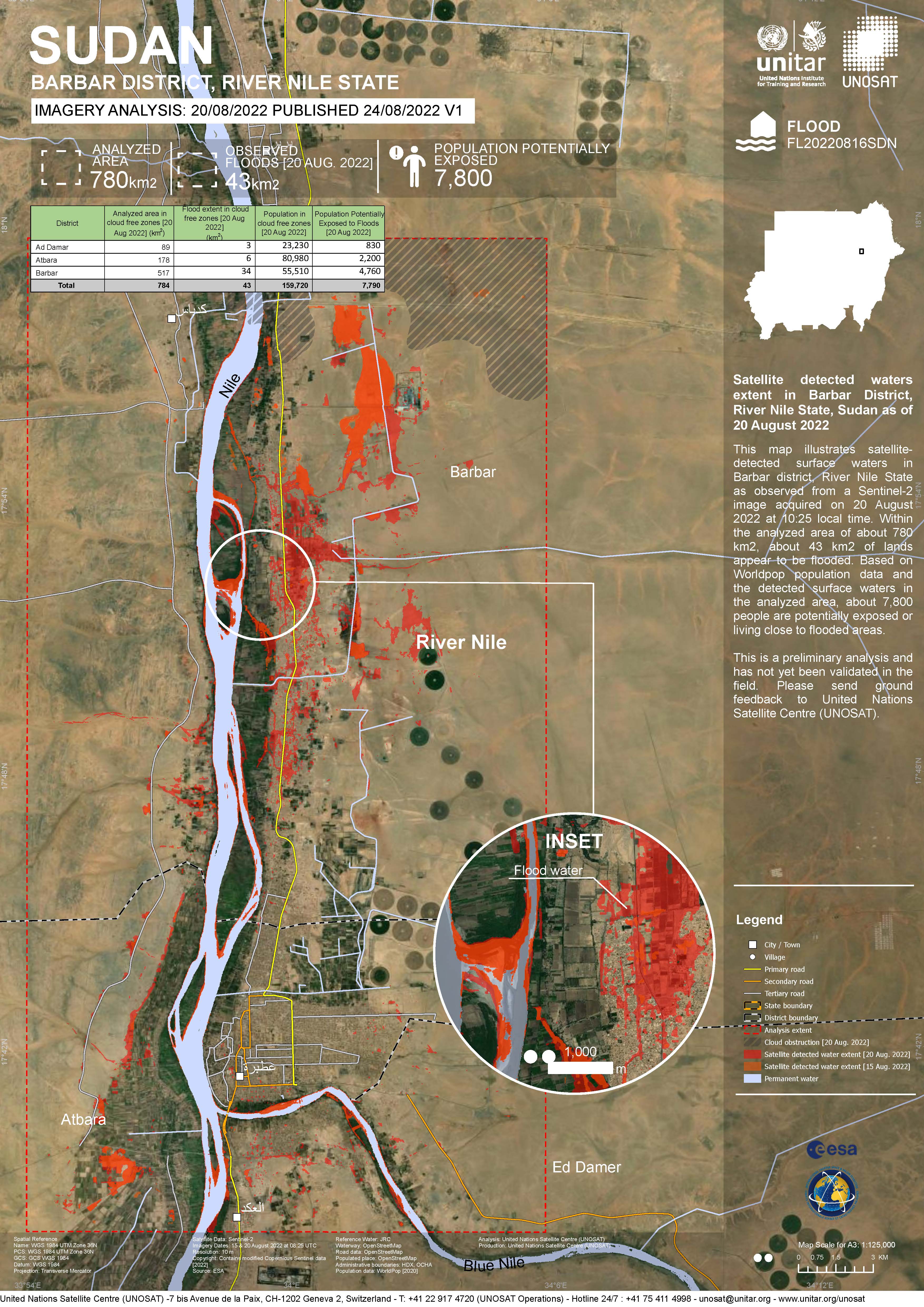
Flood situation on Sudan, Dongola
Авторские права: WorldView-2 © (2022) DigitalGlobe, Inc., Longmont CO USA 80503. DigitalGlobe and the DigitalGlobe logos are trademarks of DigitalGlobe, Inc. The use and/or dissemination of this data and/or of any product in any way derived there from are restricted. Unauthorized use and/or dissemination is prohibited.
Landsat data and products © NASA/USGS (2022) - All Rights Reserved.
Map produced by UE GeoInformation Systems
Information about the Product
Получено: WorldView-2: 07/09/2022
Landsat 8: 20/07/2022
Landsat 9: 29/08/2022
Источник: WorldView-2, Landsat 8, Landsat 9
Категория: Delineation Monitoring Maps
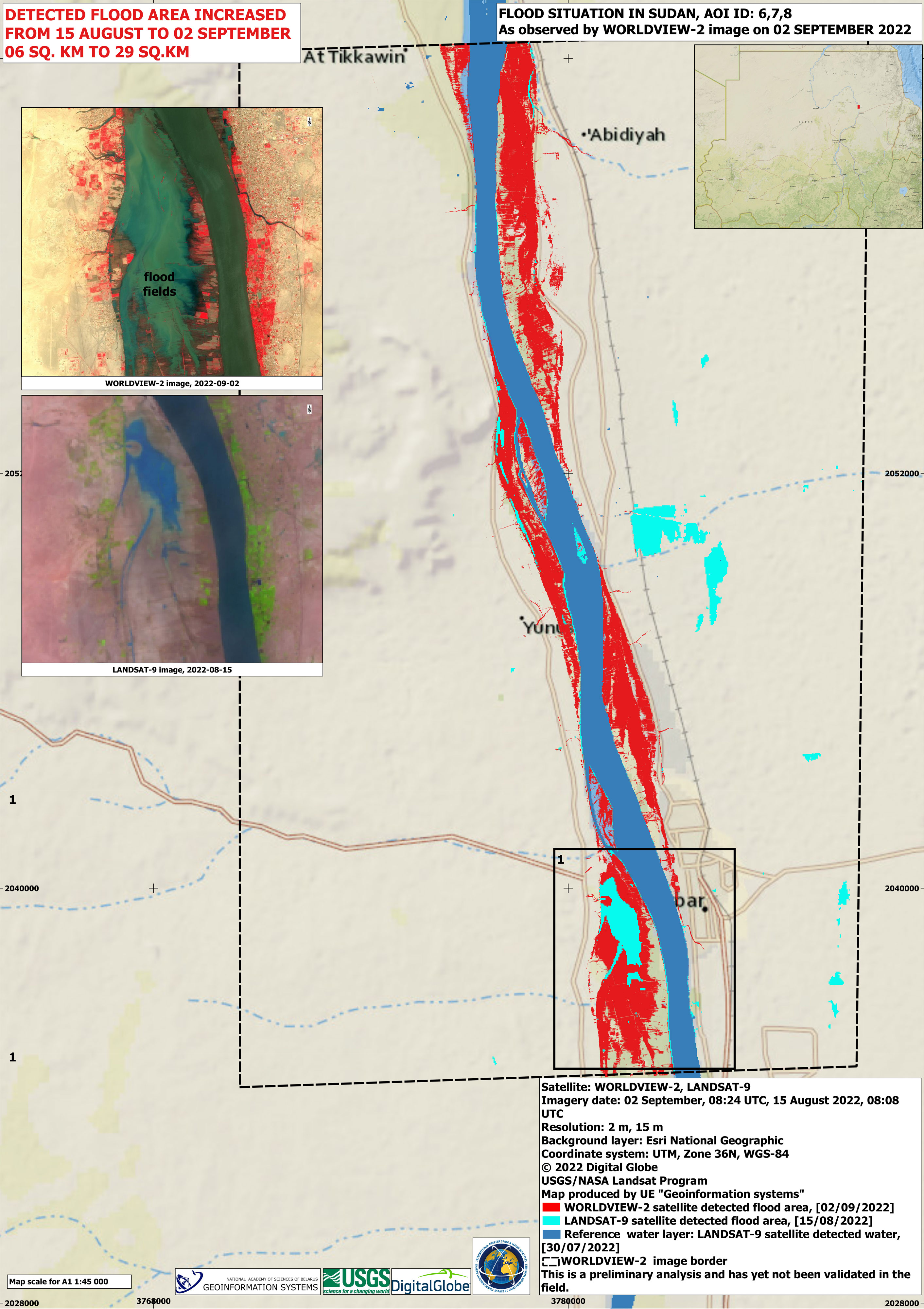
Flood situation in Sudan
Авторские права: Landsat 9 © Landsat data and products © NASA/USGS (2022) - All Rights Reserved
WorldView-2 © (2022) DigitalGlobe, Inc., Longmont CO USA 80503. DigitalGlobe and the DigitalGlobe logos are trademarks of DigitalGlobe, Inc. The use and/or dissemination of this data and/or of any product in any way derived there from are restricted. Unauthorized use and/or dissemination is prohibited.
Map produced by UE "Geoinformation systems"
Information about the Product
Получено: Landsat 9: 30/07/2022, 15/08/2022
WorldView-2: 02/09/2022
Источник: Landsat 9 / WorldView-2
Категория: Delineation Monitoring Maps
Flood situation in Sudan, Al Manaqil
Авторские права: Landsat data and products © NASA/USGS (2022) - All Rights Reserved
Map produced by UE Geo-information Systems
Information about the Product
Получено: Landsat 8: 06/07/2022, 23/08/2022
Landsat 9: 31/08/2022
Источник: Landsat 8 and Landsat 9
Категория: Delineation Monitoring Maps

Flood situation in Umm Dukhun District, Central Darfur, Sudan
Авторские права: © DLR e.V. (2022), Distribution Airbus DS Geo GmbH
Map produced by UE "Geoinformation systems"
Information about the Product
Получено: TanDEM-X: 28/08/2022
TerraSAR-X: 01/04/2010
Источник: TanDEM-X / TerraSAR-X
Категория: Reference Map
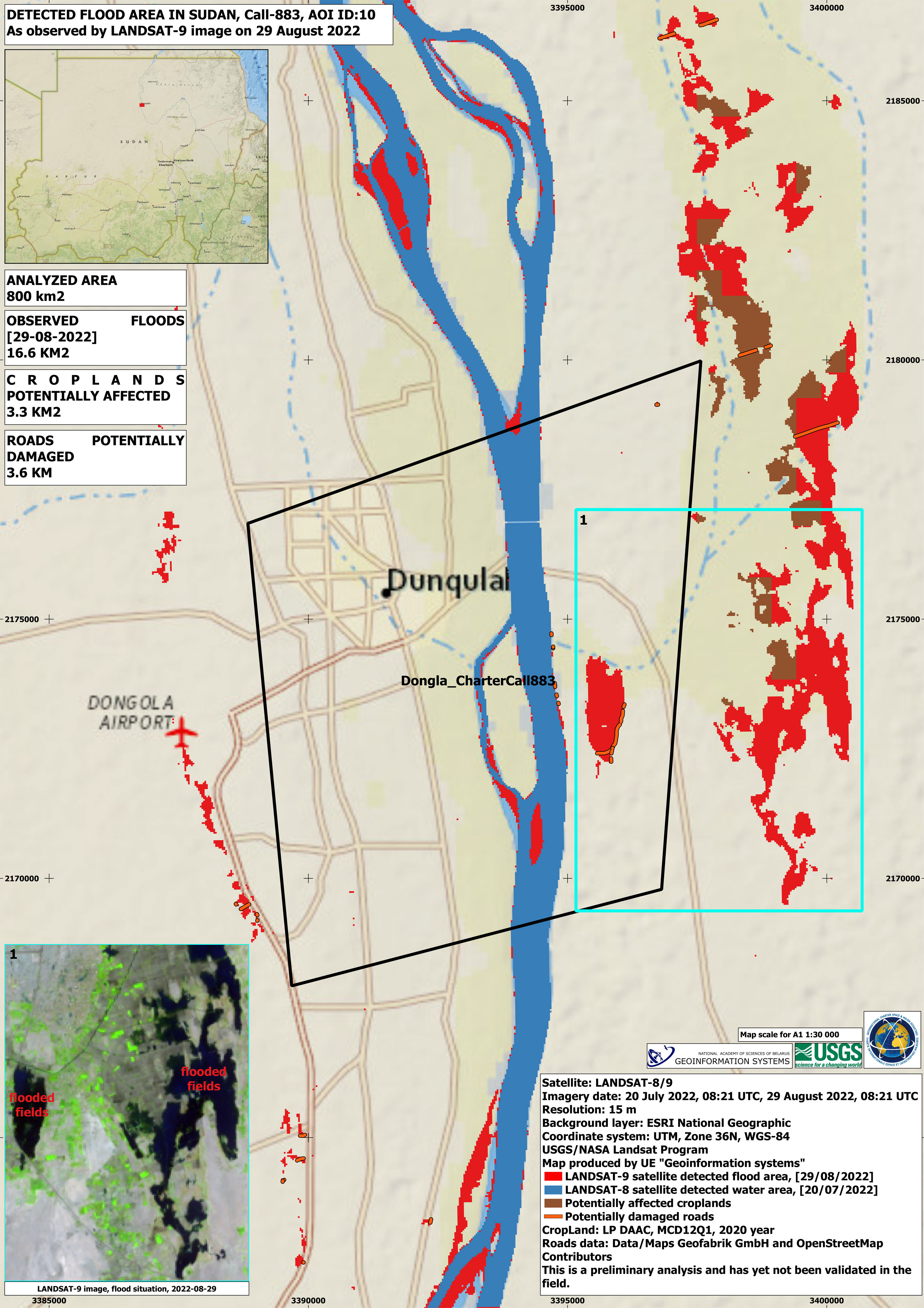
Detected flood area in Dongola, Sudan
Авторские права: Landsat data and products © NASA/USGS (2022) - All Rights Reserved
Map produced by UE "Geoinformation systems"
Information about the Product
Получено: Landsat 8: 20/07/2022
Landsat 9: 29/08/2022
Источник: Landsat 8/ Landsat 9
Категория: Reference Map
Flood assessment, Umm Dukhun District, Central Darfur, Sudan
Download full report
Авторские права: Contains modified Copernicus Sentinel data (2022)
Report produced by UNITAR/UNOSAT
Information about the Product
Получено: 22/08/2022
Источник: Sentinel-2
Категория: Delineation Map
 Вернуться к полному архиву активаций

