 English
 Spanish
 French
 Chinese
 Russian
 Portuguese
 Latest Activation
Charter activations
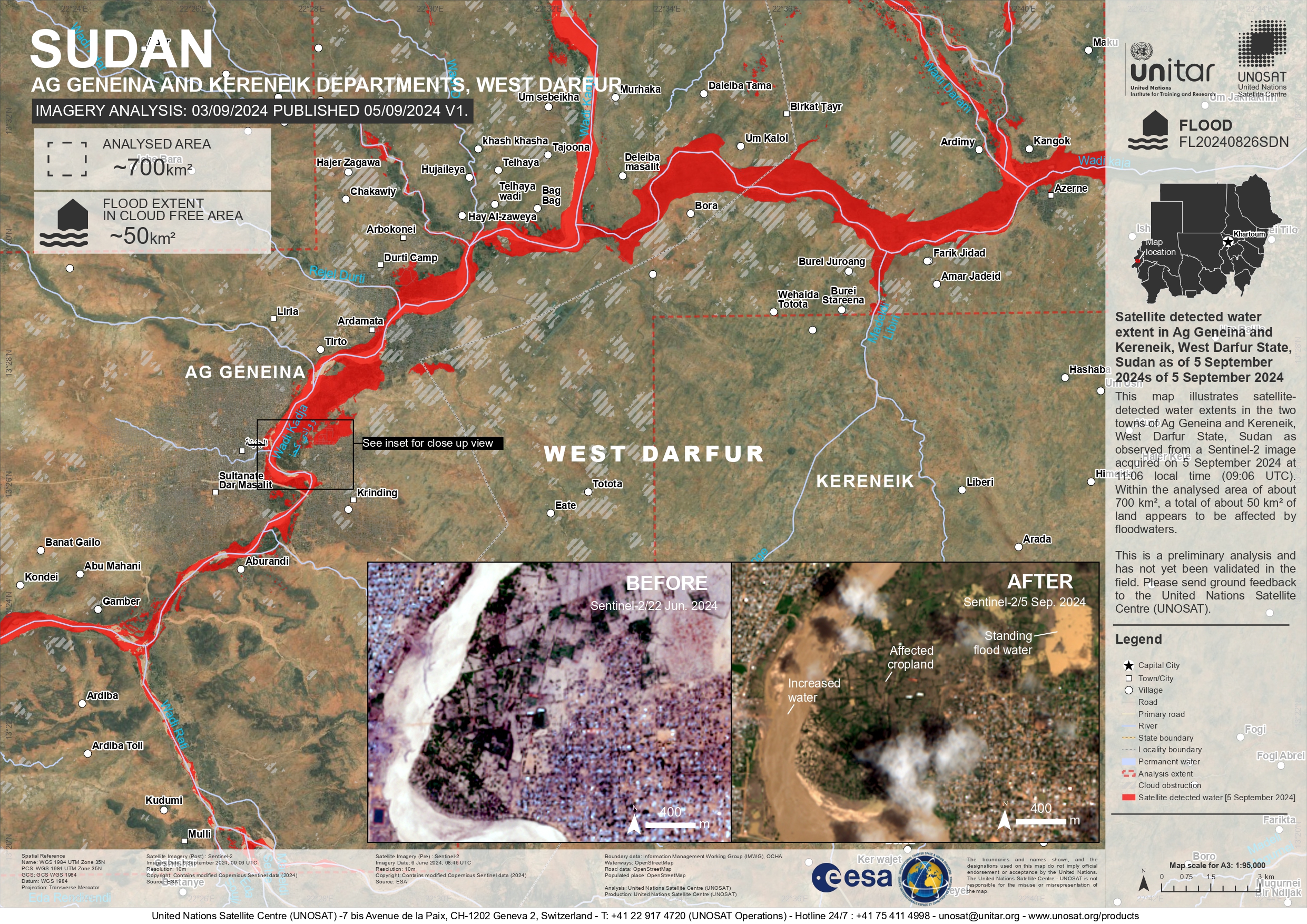
Flood in Sudan
After months of heavy rainfall, Arbaat dam in the Red Sea state of Sudan collapsed on 25 August 2024. The dam has a capacity of 25 million cubic metres and was the main source of drinking water for the city of Port Sudan.
Water from the burst dam swept away and destroyed nearby farms and villages, leaving thousands of residents displaced. Additionally, the torrential rains have also damaged fibre-optic cables causing a communication outage in many parts of the country for the second day in a row.
It was reported that Sudan's air force is conducting search and rescue operations for people who sought refuge in the mountains. The current death toll totals to 60. However, there are concerns that the death toll could rise even higher.
Related Resources:
Live Web Map for flood in Sudan
| Type of Event: | Flood |
| Location of Event: | Sudan |
| Date of Charter Activation: | 2024-08-28 |
| Time of Charter Activation: | 10:50 |
| Time zone of Charter Activation: | UTC+02:00 |
| Charter Requestor: | UNOSAT on behalf of WHO - World Health Organization |
| Activation ID: | 906 |
| Project Management: | Candace Chow (UNITAR) |
| Value Adding: | Copernicus EMS (Copernicus EMS) Mohammed Bin Rashid Space Centre |
| Activation handled in collaboration with Copernicus Emergency Management Service |
Products
Grading Product with the damage grade assessment over Port Sudan.
Download full product
Copyright: ncludes Pléiades material © CNES (2024), distributed by Airbus DS
Map produced by Copernicus EMS
Information about the Product
Acquired: 28/07/2024
Source: Pléiades
Category: Grading Map

Grading Product with the damage grade assessment over Eshnik District, Sudan
Download full product
Copyright: Includes Pléiades material © CNES (2024), distributed by Airbus DS
Map produced by Copernicus EMS
Information about the Product
Acquired: 28/08/2024
Source: Pléiades
Category: Grading Map
Grading Product with the damage grade assessment over Aoi Khor Maliqirm
Download full report
Copyright: Copernicus EMS (© 2021 European Union).
Map produced by Copernicus EMS
Information about the Product
Acquired: 29/08/2024
Source: Pléiades
Category: Reference Map
Grading Monitoring with the damage grade assessment over Aoi Khor Maluqirm, Sudan
Download full product
Copyright: Copernicus EMS (© 2021 European Union).
Map produced by Copernicus EMS
Information about the Product
Acquired: 01/09/2024
Source: Pléiades
Category: Reference Map

Satellite detected water extent in Kassala and River Nile States, Sudan
Download full product
Copyright: Copernicus EMS (© 2021 European Union).
Includes Pleiades material © CNES (2024), Distribution Airbus DS.
Map produced by Copernicus EMS
Information about the Product
Acquired: 29/08/2024
Source: Pléiades
Category: Grading Map

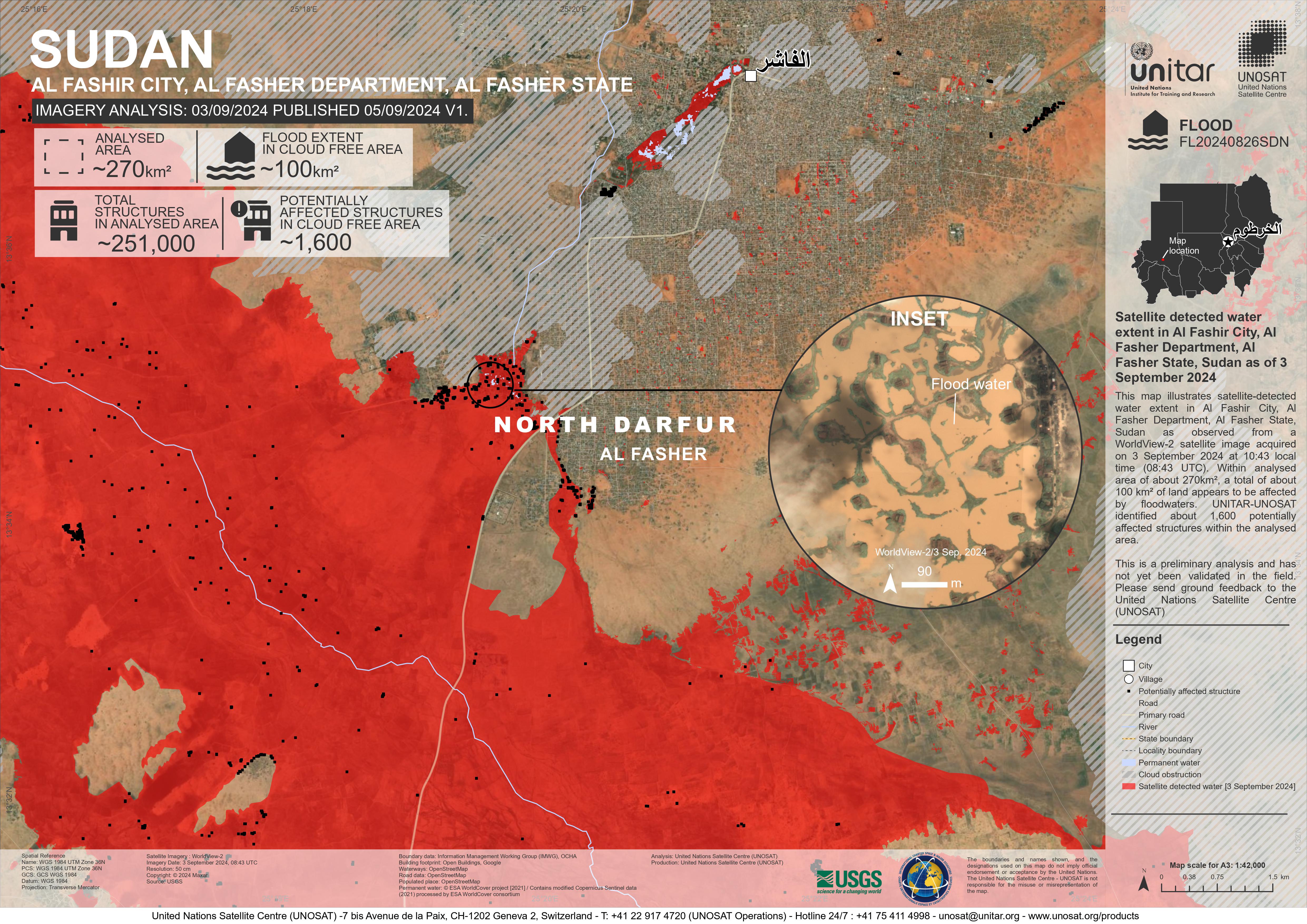
Areas affected by flooding in Al Fashir City, Al Fasher Department, Al Fasher State, Sudan
Copyright: © (2024) DigitalGlobe, Inc., Longmont CO USA 80503. DigitalGlobe and the DigitalGlobe logos are trademarks of DigitalGlobe, Inc. The use and/or dissemination of this data and/or of any product in any way derived there from are restricted. Unauthorized use and/or dissemination is prohibited
Map produced by UNITAR / UNOSAT
Information about the Product
Acquired: 03/09/2024
Source: WorldView-2
Category: Delineation Map
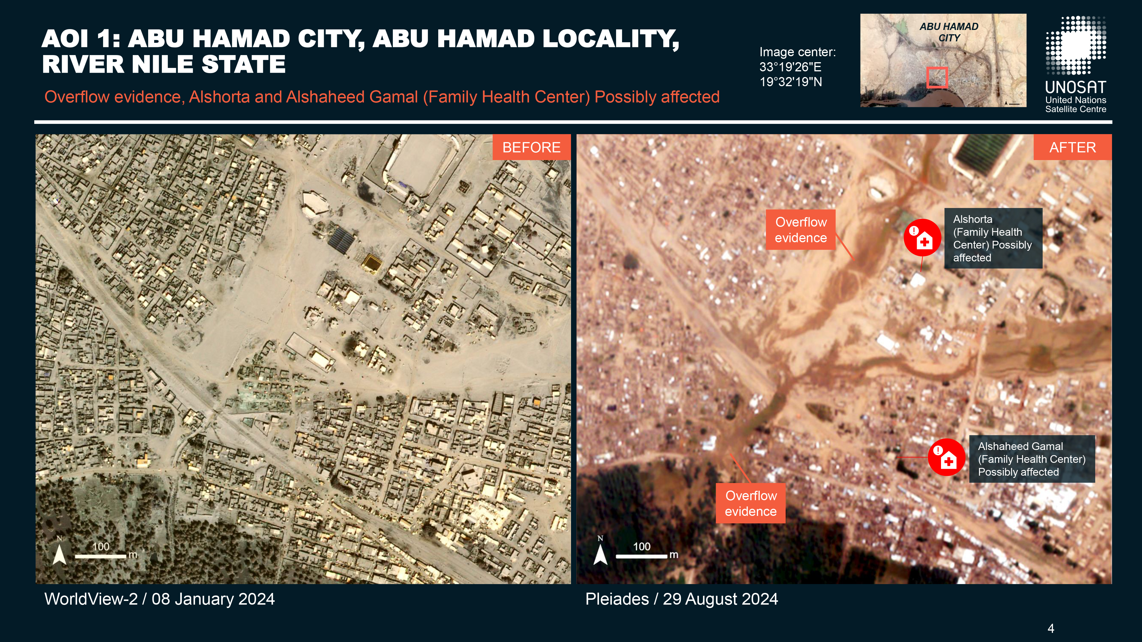
Preliminary satellite-derived impact assessment on health facilities, Abu Hamad City, Abu Hamad Locality, River Nile State.
Download full report
Copyright: Includes Pleiades material © CNES (2024), Distribution Airbus DS.
Map produced by UNITAR / UNOSAT
Information about the Product
Acquired: 29/08/2024
Source: Pleiades
Category: Dossier
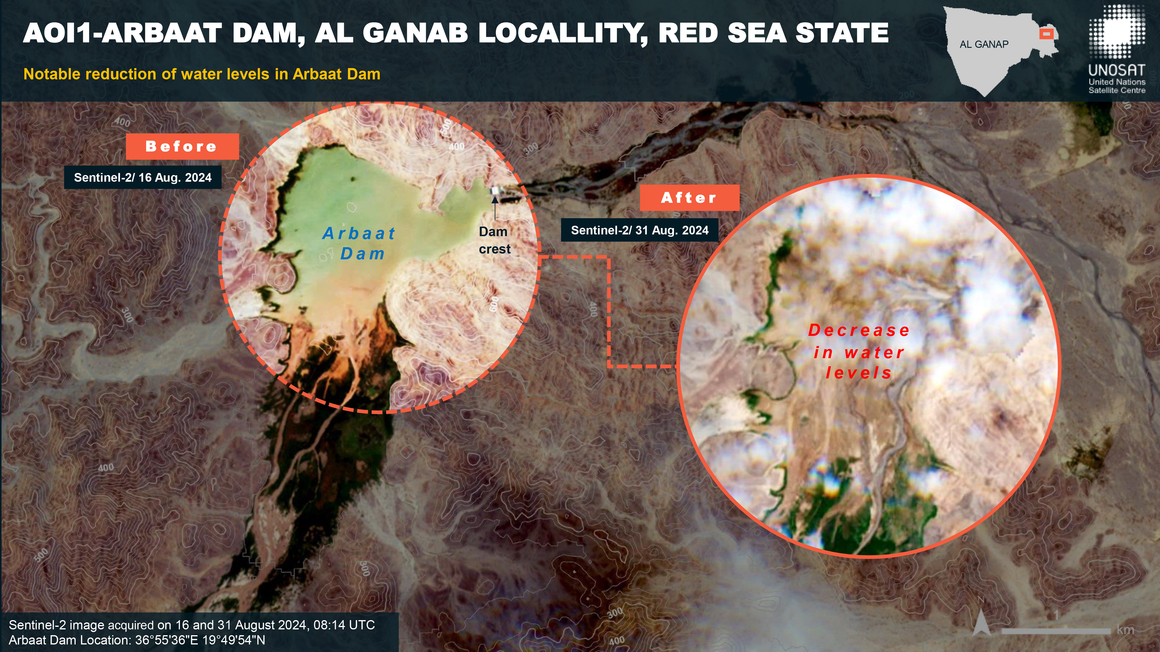
Preliminary satellite-derived impact assessment on health facilities, Arbaat Dam, Al Ganap Locality and Port Sudan, Red Sea State, Sudan.
Download full report
Copyright: Includes Pleiades material © CNES (2024), Distribution Airbus DS.
Map produced by UNITAR / UNOSAT
Information about the Product
Acquired: 30/08/2024
Source: Pleiades
Category: Dossier
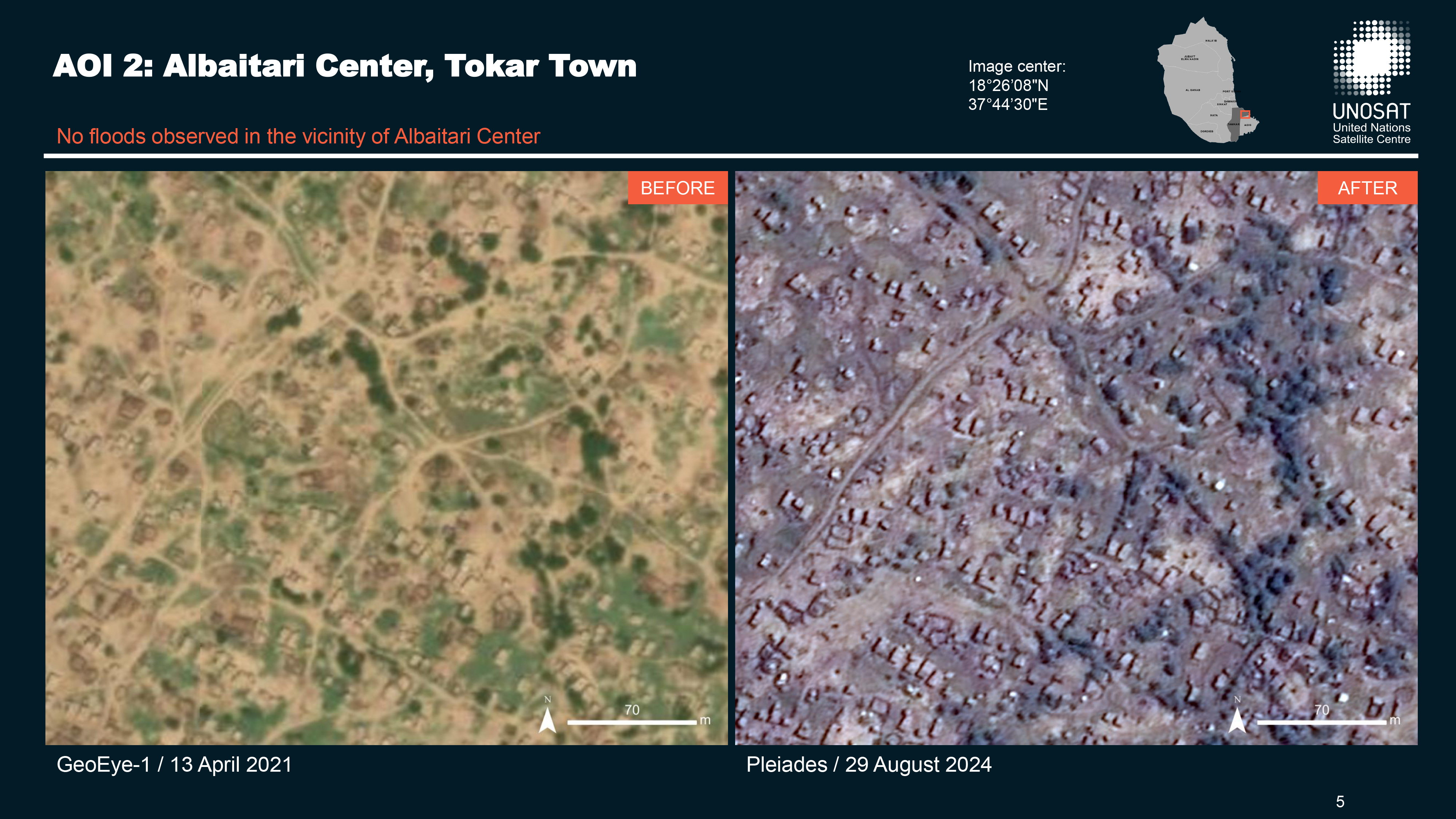
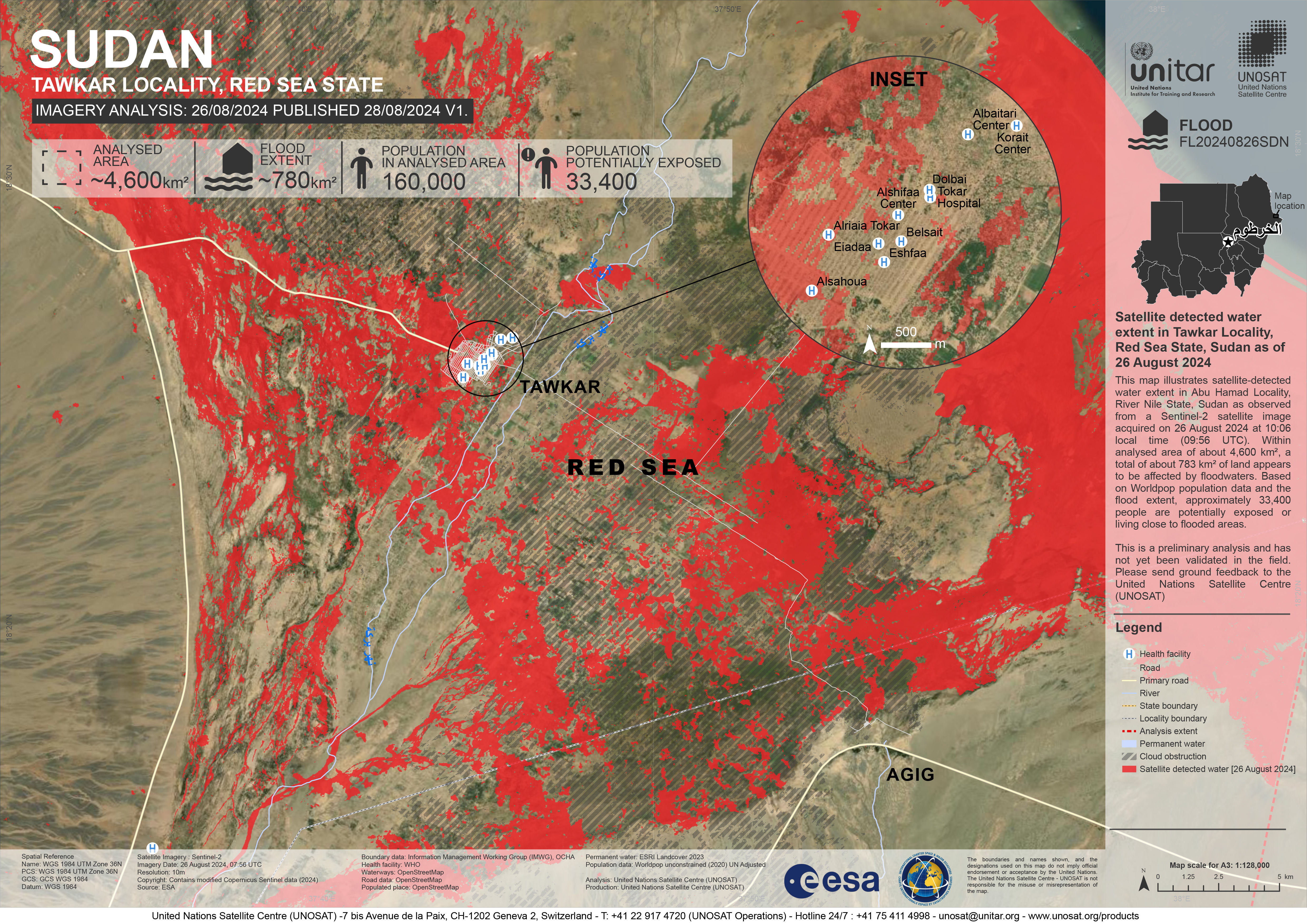
Preliminary satellite-derived impact assessment of health facilities, Tawkar Locality, Red Sea State, Sudan
Download full report
Copyright: Includes Pleiades material © CNES (2024), Distribution Airbus DS.
Map produced by UNITAR/ UNOSAT
Information about the Product
Acquired: 29/08/2024
Source: Pleiades
Category: Dossier

 Back to the full activation archive

