Charter activations
埃塞俄比亚洪水
奥莫河洪水造成埃塞俄比亚南部死亡人数超过364人。阿瓦什河地区恐怕也有重大伤亡损失。据救灾网(Reliefweb)称,自从8月初埃塞俄比亚开始强降雨以来,大约有870人死亡。由于难以到达受灾地区,死亡人数可能会很高。
| 事件类型: | 洪水 |
| 事件地点: | 埃塞俄比亚 |
| 启动宪章的日期: | 2006年8月17日 |
| 宪章要求者: | UN OOSA代表WFP |
| 项目经理: | UNOSAT |
Products

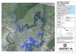
SW Ethiopia Post Disaster Likely flood affected areas have been extracted from SPOT-5 image acquired on 13 August 2006. On this map also figure human settlements, main roads, and elevation contour lines.
版权: CNES 2006
Image processing, map created 22/08/2006 by UNOSAT in the framework of GMES Respond.
10.5m resolution
Information about the Product
已获得: 13/08/2006
源: SPOT-5

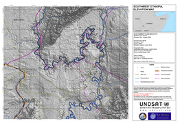
SW Ethiopia Elevation Map Altitude map (contour lines every 100m) of South Omo province, Ethiopia. On this map also figure human settlements and main roads.
版权: NASA 2006 Image processing, map created 22/08/2006 by UNOSAT in the framework of GMES Respond.
90 m resolution
Information about the Product
已获得: 13/08/2006
源: Elevation data: SRTM

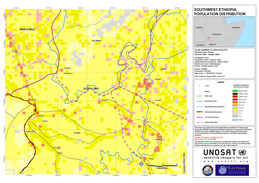
SW Ethiopia Population distribution Population distribution of South Omo Province, Ethiopia. The map shows roads, rivers, main human settlements, and administrative boundaries.
版权: Population data: Landscan 2002; Administrative boundaries: USAID/ OFDA; Roads and rivers: GlobalInsight; Places: GeoNet Names, NGA Image processing, map created 21/08/2006 by UNOSAT in the framework of GMES Respond.
90 m resolution
Information about the Product
已获得: 21/08/2006
源: Landscan 2002
 返回完整的响应档案

 English
 Spanish
 French
 Chinese
 Russian
 Portuguese


