Charter activations
匈牙利洪灾
2006年3月底和4月初匈牙利的强降雨和融雪造成多瑙河的主要支流提萨河(Tisza)达到上世纪以来最大流量。布拉格、布达佩斯和贝尔格莱德等城市受到威胁;到4月中已有数千人撤离。
| 事件类型: | 洪灾 |
| 事件地点: | 匈牙利 |
| 启动宪章的日期: | 2006年4月14日 |
| 宪章要求者: | 欧洲委员会民事保护监测与信息中心 |
| 项目经理: | DLR |
Products

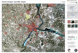
Hungary, Tisza Flood: Szeged
版权: Canadian Space Agency 2006, USGS 2000 Image processing, map created 18/04/2006 by DLR in the framework of GMES RISKEOS.
Information about the Product
已获得: 15/04/2006, 20/08/2000 The map shows the city of Szeged in Hungary during the flooding event of the Danube/Tisza rivers in April 2006. The flooded area has been extracted from radar satellite data (RADARSAT) acquired on 17 April 2006. The background satellite image is based on Landsat 7 ETM+ data acquired on 20 August 2000 displayed as real colour composite. The flooded area has been mapped with highest possible accuracy.
源: RADARSAT-1, Landsat 7 ETM+

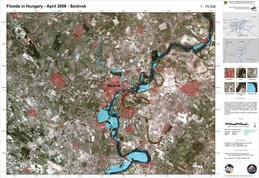
Hungary, Tisza Flood: Szolnok
版权: Canadian Space Agency 2006, USGS 2000 Image processing, map created 18/04/2006 by DLR in the framework of GMES RISKEOS.
Information about the Product
已获得: 15/04/2006, 20/08/2000 The map shows the city of Szolnok in Hungary during the flooding event of the Danube/Tisza rivers in April 2006. The flooded area has been extracted from radar satellite data (RADARSAT) acquired on 17 April 2006. The background satellite image is based on Landsat 7 ETM+ data acquired on 20 August 2000 displayed as real colour composite. The flooded area has been mapped with highest possible accuracy.
源: RADARSAT-1, Landsat 7 ETM+
 返回完整的响应档案

 English
 Spanish
 French
 Chinese
 Russian
 Portuguese


