Charter activations
Flooding in Hungary
Heavy rainfall and snowmelt in Hungary at the end of March and in April 2006 caused the highest peak of overflow in the last century of the river Tisza, a major tributary of the Danube. The cities of Prague, Budapest, and Belgrade were threatened; by mid-April, thousands had been evacuated.
| Тип события: | Flooding |
| Место события: | Hungary |
| Date of Charter Activation: | 14/04/2006 |
| Запрос на активацию поступил от: | European Commission Civil Protection Monitoring and Information Centre |
| Менеждер проекта от: | DLR |
Products

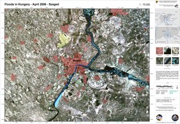
Hungary, Tisza Flood: Szeged
Авторские права: Canadian Space Agency 2006, USGS 2000 Image processing, map created 18/04/2006 by DLR in the framework of GMES RISKEOS.
Information about the Product
Получено: 15/04/2006, 20/08/2000 The map shows the city of Szeged in Hungary during the flooding event of the Danube/Tisza rivers in April 2006. The flooded area has been extracted from radar satellite data (RADARSAT) acquired on 17 April 2006. The background satellite image is based on Landsat 7 ETM+ data acquired on 20 August 2000 displayed as real colour composite. The flooded area has been mapped with highest possible accuracy.
Источник: RADARSAT-1, Landsat 7 ETM+

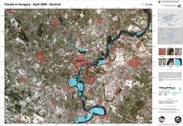
Hungary, Tisza Flood: Szolnok
Авторские права: Canadian Space Agency 2006, USGS 2000 Image processing, map created 18/04/2006 by DLR in the framework of GMES RISKEOS.
Information about the Product
Получено: 15/04/2006, 20/08/2000 The map shows the city of Szolnok in Hungary during the flooding event of the Danube/Tisza rivers in April 2006. The flooded area has been extracted from radar satellite data (RADARSAT) acquired on 17 April 2006. The background satellite image is based on Landsat 7 ETM+ data acquired on 20 August 2000 displayed as real colour composite. The flooded area has been mapped with highest possible accuracy.
Источник: RADARSAT-1, Landsat 7 ETM+
 Вернуться к полному архиву активаций

 English
 Spanish
 French
 Chinese
 Russian
 Portuguese


