 English
 Spanish
 French
 Chinese
 Russian
 Portuguese
 最新宪章启动
Charter activations
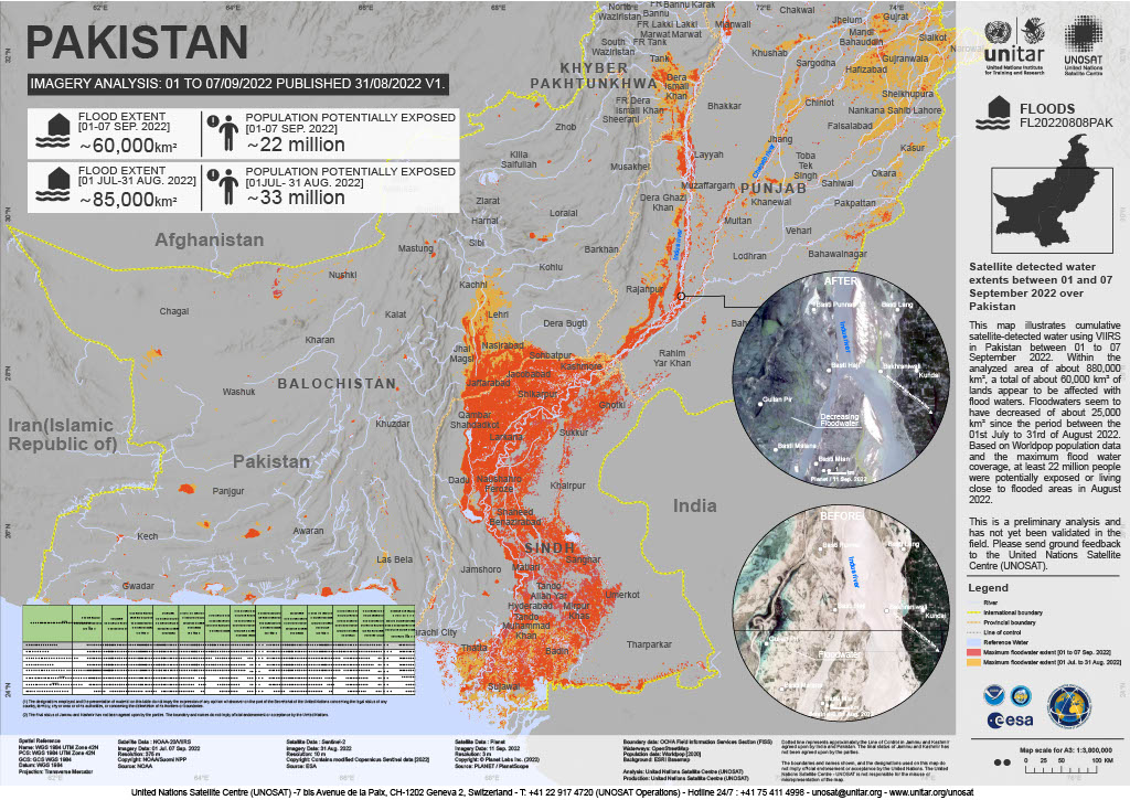
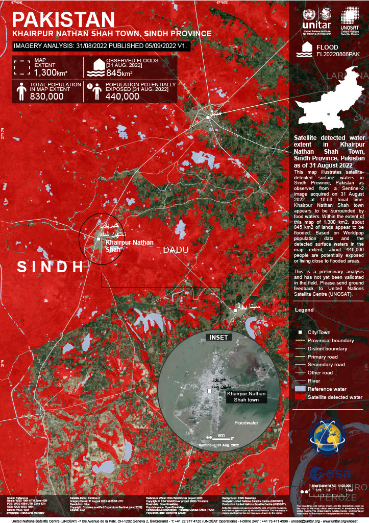
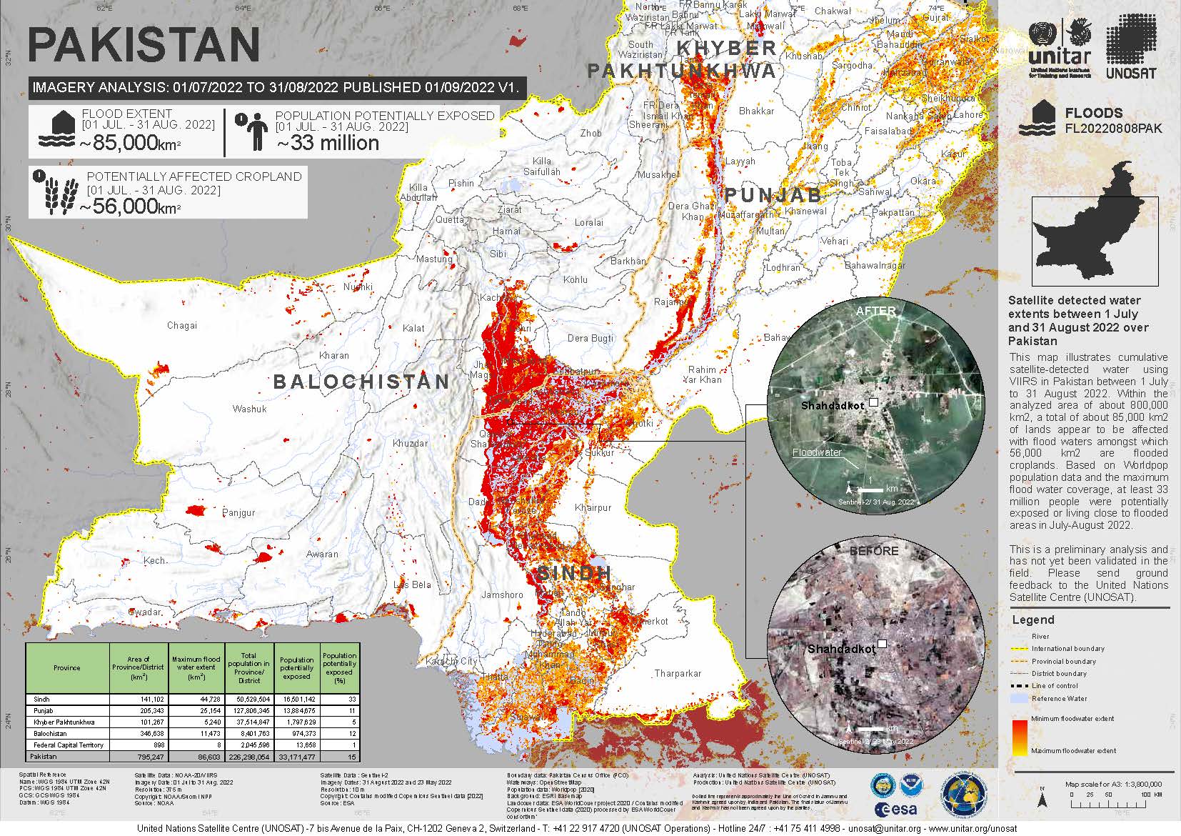
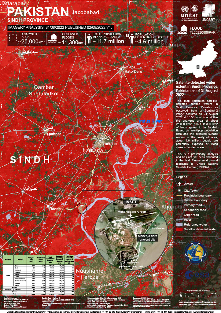
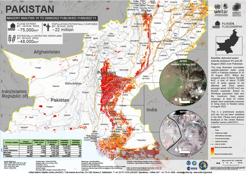
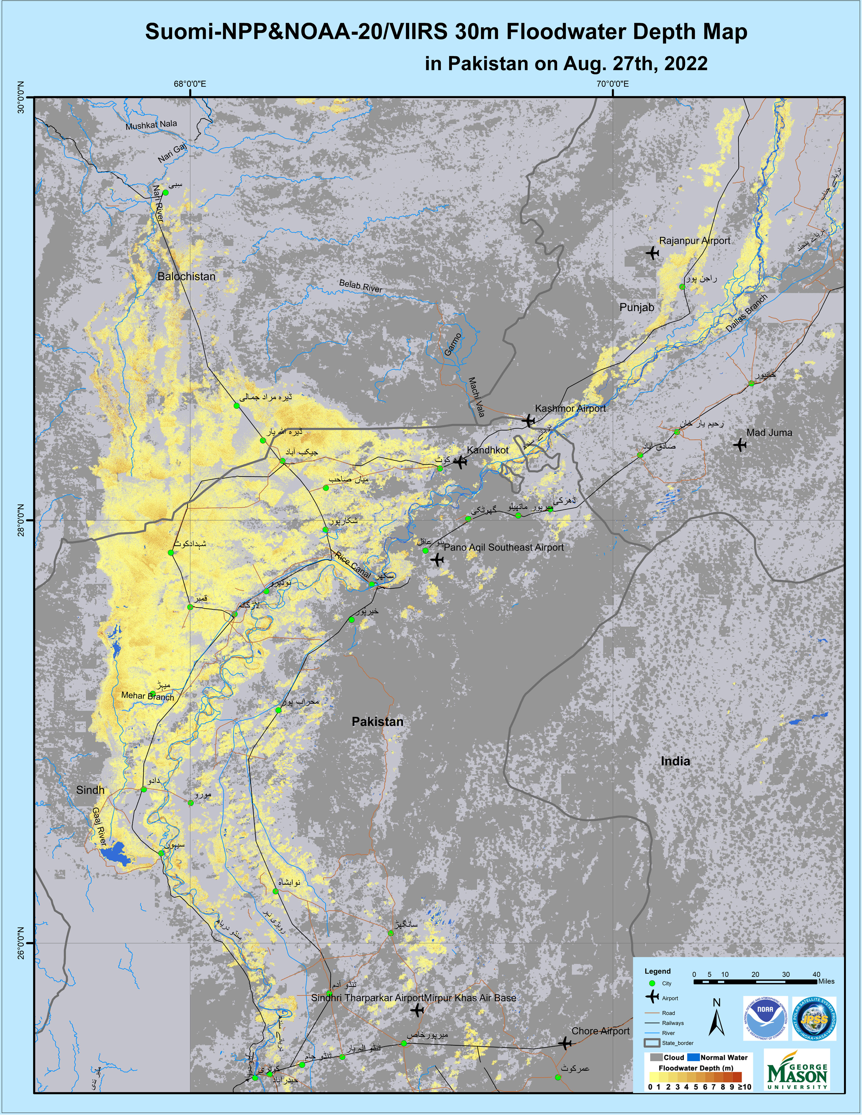
Flood in Pakistan
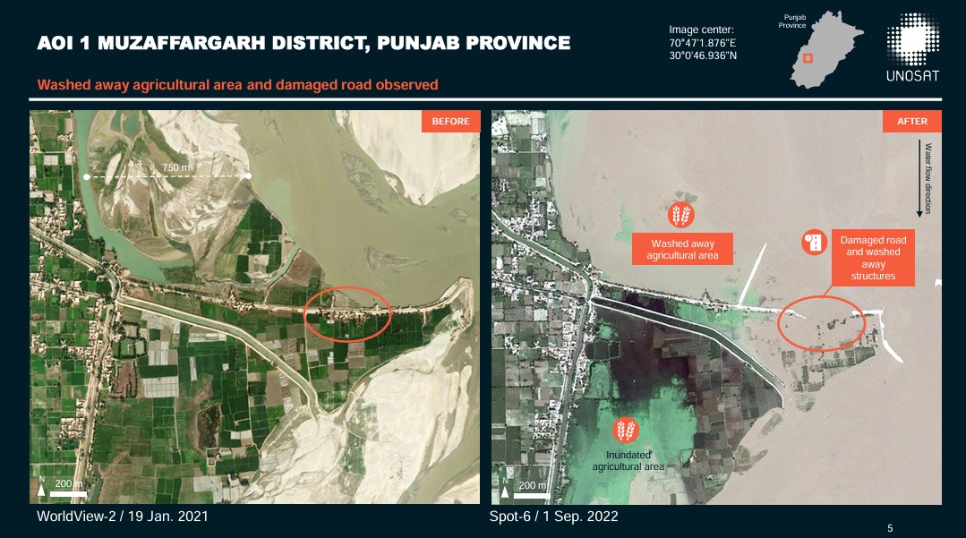
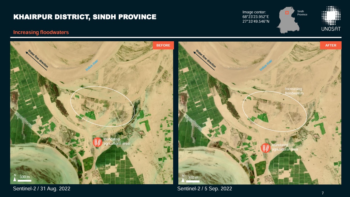
One-third of Pakistan was completely submerged in floods. Roads, homes and crops were completely washed away.
According to officials 1,136 people died since the monsoon season began in June. 1 in 7 people have been affected by the historic flooding.
Thousands of people living in mountainous areas were ordered to evacuate.
Related News and Resources
| 事件类型: | Floods |
| 事件地点: | Pakistan |
| 启动宪章的日期: | 2022-08-30 |
| 宪章启动时间: | 15:35 |
| 宪章启动时区: | UTC+02:00 |
| 宪章要求者: | UNITAR on behalf of United Nations Office for the Coordination of Humanitarian Affairs (OCHA) | Regional Office for Asia and the Pacific |
| 启动ID: | 772 |
| 项目经理: | UNITAR |
Products
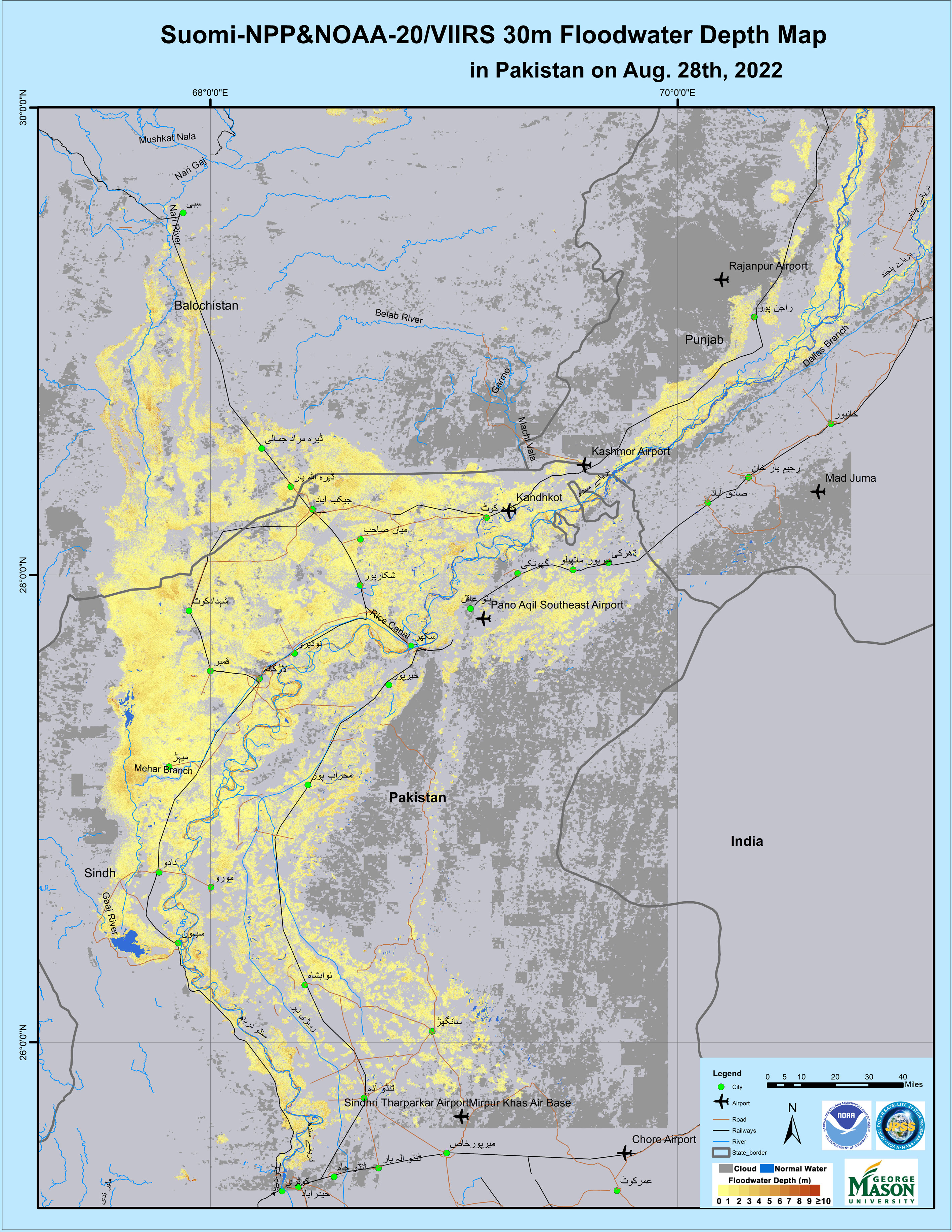
Preliminary Satellite Derived Flood Evolution Assessment, Islamic Republic of Pakistan
Download full report
版权: © NASA/NOAA (2022)
Report produced by UNOSAT
Information about the Product
已获得: 11/10/2022
源: Suomi NPP
类别: Delineation Monitoring Maps
Preliminary Satellite Derived Flood Evolution Assessment
Download the full report
版权: © NASA/NOAA (2022)
Report produced by UNOSAT
Information about the Product
已获得: 02/10/2022, 26/09/2022, 21/09/2022
源: Suomi NPP
类别: Gradient Monitoring Maps
Satellite-derived flood evolution assessment report
Download the full report
版权: © NASA/NOAA (2022)
Map produced by UNOSAT
Information about the Product
已获得: 23/09/2022
源: Suomi NPP
类别: Gradient Monitoring Maps
Preliminary satellite-derived flood evolution assessment
Download the full report
版权: © NASA/NOAA (2022)
Report produced by UNOSAT, United Nations Institute for Training and Research (UNITAR)
Information about the Product
已获得: 14/09/2022
源: Suomi NPP
类别: Reference Map
Satellite detected water extents over Pakistan
版权: Contains modified Copernicus Sentinel data (2022)
Suomi NPP © NASA/NOAA (2022)
PlanetScope © Planet Labs Inc. (2022)
Map produced by UNITAR / UNOSAT
Information about the Product
已获得: Sentinel-2: 31/08/2022
Suomi NPP: 07/09/2022
PlanetScope: 11/09/2022
源: Sentinel-2, Suomi NPP, PlanetScope
类别: Delineation Map
Preliminary Satellite Derived Flood Assessment in Punjab Province, Pakistan
Download the Full Report
版权: WorldView-2 and WorldView-3 © (2021 and 2022) DigitalGlobe, Inc., Longmont CO USA 80503. DigitalGlobe and the DigitalGlobe logos are trademarks of DigitalGlobe, Inc. The use and/or dissemination of this data and/or of any product in any way derived there from are restricted. Unauthorized use and/or dissemination is prohibited.
SPOT-6: Includes material © Airbus DS (2022)
GeoEye-1 © 2004 GeoEye NextView License
Map produced by UNITAR/UNOSAT.
Information about the Product
已获得: SPOT-6: 01/09/2022
WorldView-3: 29/08/2022
WorldView-2: 19/01/2021, 15/02/2021
GeoEye-1: 07/05/2021
源: SPOT-6, WorldView-3, WorldView-2 and GeoEye-1
类别: Grading Map
Preliminary Satellite Derived Flood Evolution Assessment, Islamic Republic of Pakistan
Download the full report
版权: SPOT-6 © Includes material © Airbus DS (2022)
Sentinel-2 © Contains modified Copernicus Sentinel data (2022)
Suomi NPP © NASA/NOAA (2022)
JILIN-01 © 21AT (2022)
GeoEye-1 © 2004 GeoEye NextView License
WorldView-2 © (2021) DigitalGlobe, Inc., Longmont CO USA 80503. DigitalGlobe and the DigitalGlobe logos are trademarks of DigitalGlobe, Inc. The use and/or dissemination of this data and/or of any product in any way derived there from are restricted. Unauthorized use and/or dissemination is prohibited.
Report produced by UNOSAT
Information about the Product
已获得: SPOT-6: 01/09/2022
Sentinel-2: 31/08/2022, 05/09/2022
Suomi NPP: 31/08/2022
JILIN-01 Optical-A: 01/09/2022
GeoEye-1: 06/01/2021
WorldView-2: 10/05/2021
源: SPOT-6 / Sentinel-2 / Suomi NPP / JILIN-01 Optical-A / GeoEye-1 / WorldView-2
类别: Grading Map
 返回完整的响应档案

