Charter activations
巴基斯坦洪水
雨季的降水导致巴基斯坦旁遮普与信德两省暴发大面积洪水,据报道已造成130余人死亡,政府报告显示可能有多达100万人受灾。
降雨始于8月初,引发的暴洪迄今已摧毁10000间房屋,据报道已致使近2000个村庄受灾,已有15000人被疏散至避难营地。
洪水还对作物和牲畜造成影响,预计导致数十万英亩作物被毁,5000头牲畜死亡。这些损失将给依赖种植业作为食物来源的当地村民带来长期影响。当地的道路已被淹没,更加阻碍了救援行动的开展和人员的流动迁移。
预报显示降雨仍将持续,预计洪水在流向下游的过程中还会侵袭更多村庄。
| 事件类型: | 洪水 |
| 事件地点: | 巴基斯坦旁遮普省和信德省 |
| 启动宪章的日期: | 2013年8月22日 |
| 宪章要求者: | UNITAR/UNOSAT代表UNESCAP |
Products
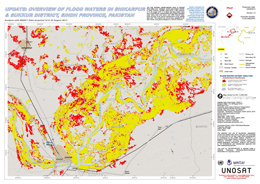
Update: Overview of flood waters in Shikarpur and Sukkur District, Sindh Province, Pakistan
版权: RISAT-1: Indian Space Research Organisation
TerraSAR-X: German Aerospace Center (DLR), 2013 Astrium Services/Infoterra GmbH
Map produced by UNITAR/UNOSAT
Information about the Product
已获得: RISAT-1: 14/08/2013 and 26/08/2013
TerraSAR-X: 27/03/2010
源: RISAT-1 / TerraSAR-X

Update: Overview of flood waters in Sialkot and Narowal Districts, Punjab Province, Pakistan
版权: TerraSAR-X: German Aerospace Center (DLR), Astrium Services/Infoterra GmbH 2013
RADARSAT-2 Data and Products © MacDonald, Dettwiler and Associates Ltd. (2013) - All Rights Reserved. RADARSAT is an official trademark of the Canadian Space Agency.
Map produced by UNITAR/UNOSAT
Information about the Product
已获得: RADARSAT-2: 25/08/2013
TerraSAR-X: 27/08/2013
源: TerraSAR-X / RADARSAT-2
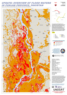
Update: Overview of flood waters in Punjab Province, Pakistan
版权: RADARSAT-2 Data and Products © MacDonald, Dettwiler and Associates Ltd. (2013) - All Rights Reserved. RADARSAT is an official trademark of the Canadian Space Agency.
SPOT-5: CNES 2013
Map produced by UNITAR / UNOSAT
Information about the Product
已获得: SPOT-5: 25/08/2013
RADARSAT-2: 26/08/2013
源: RADARSAT-2 / SPOT-5
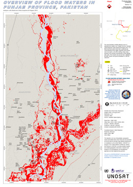
Overview of flood waters in Punjab province, Pakistan
版权: RADARSAT-2 Data and Products © MacDonald, Dettwiler and Associates Ltd. (2013) - All Rights Reserved. RADARSAT is an official trademark of the Canadian Space Agency.
Map produced by UNITAR / UNOSAT
Information about the Product
已获得: 26/08/2013
源: RADARSAT-2
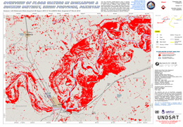
Overview of flood waters in Shikarpur and Sukkur Sistrict, Sindh Province, Pakistan
版权: TerraSAR-X German Aerospace Center (DLR), 2013 Astrium/Services/Infoterra GmbH
RADARSAT-2 Data and Products © MacDonald, Dettwiler and Associates Ltd. (2013) - All Rights Reserved. RADARSAT is an official trademark of the Canadian Space Agency.
Map produced by UNITAR / UNOSAT
Information about the Product
已获得: 26/08/2013
源: RADARSAT-2 & TerraSAR-X

Overview of flood waters in Sialkot and Narwol Districts
版权: RADARSAT-2 Data and Products © MacDonald, Dettwiler and Associates Ltd. (2013) - All Rights Reserved. RADARSAT is an official trademark of the Canadian Space Agency.
Map produced by UNITAR / UNOSAT
Information about the Product
已获得: Pre-crisis: 17/10/2012
Post-crisis: 25/08/2013
源: RADARSAT-2
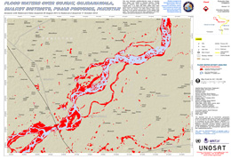
Flood waters over Gujrat, Gujranawala, Sialkot districts, Pujab Province, Pakistan
版权: RADARSAT-2 Data and Products © MacDonald, Dettwiler and Associates Ltd. (2013) - All Rights Reserved. RADARSAT is an official trademark of the Canadian Space Agency.
Map produced by UNITAR / UNOSAT
Information about the Product
已获得: Pre-crisis: 17/10/2012
Post-crisis: 25/08/2013
源: RADARSAT-2
 返回完整的响应档案

 English
 Spanish
 French
 Chinese
 Russian
 Portuguese


