Charter activations
Flood in Pakistan
Monsoon rains have lead to widespread flooding in the Punjab and Sindh Province's of Pakistan, where over 130 people have been reported killed and government reports indicate that as many as 1 million may be affected.
The rain began in early August and has resulted in flash floods which have destroyed 10,000 homes so far and reportedly affected almost 2000 villages. 15,000 people have been evacuated to relief camps.
The flood waters have also affected crops and cattle, killing an estimated 5000 cattle and destroying hundreds of thousands of acres of crops. These losses will lead to long-term consequences for the local villagers, who rely on the farms for their food. Local roads have been inundated, further hampering relief efforts and disrupting travel.
More rain is forecast and it is expected that the floodwaters will affect more villages as they flow downstream.
| Tipo de evento: | Flood |
| Local do evento: | Punjab and Sindh Provinces, Pakistan |
| Data da Ativação da Carta: | 22 August 2013 |
| Requisitante da Carta: | UNITAR/UNOSAT on behalf of UNESCAP |
| Gerenciamento de projeto: | UNITAR/UNOSAT |
Products
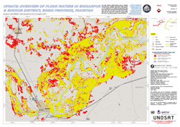
Update: Overview of flood waters in Shikarpur and Sukkur District, Sindh Province, Pakistan
Direitos autorais: RISAT-1: Indian Space Research Organisation
TerraSAR-X: German Aerospace Center (DLR), 2013 Astrium Services/Infoterra GmbH
Map produced by UNITAR/UNOSAT
Information about the Product
Adquirida: RISAT-1: 14/08/2013 and 26/08/2013
TerraSAR-X: 27/03/2010
Fonte: RISAT-1 / TerraSAR-X

Update: Overview of flood waters in Sialkot and Narowal Districts, Punjab Province, Pakistan
Direitos autorais: TerraSAR-X: German Aerospace Center (DLR), Astrium Services/Infoterra GmbH 2013
RADARSAT-2 Data and Products © MacDonald, Dettwiler and Associates Ltd. (2013) - All Rights Reserved. RADARSAT is an official trademark of the Canadian Space Agency.
Map produced by UNITAR/UNOSAT
Information about the Product
Adquirida: RADARSAT-2: 25/08/2013
TerraSAR-X: 27/08/2013
Fonte: TerraSAR-X / RADARSAT-2
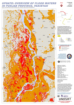
Update: Overview of flood waters in Punjab Province, Pakistan
Direitos autorais: RADARSAT-2 Data and Products © MacDonald, Dettwiler and Associates Ltd. (2013) - All Rights Reserved. RADARSAT is an official trademark of the Canadian Space Agency.
SPOT-5: CNES 2013
Map produced by UNITAR / UNOSAT
Information about the Product
Adquirida: SPOT-5: 25/08/2013
RADARSAT-2: 26/08/2013
Fonte: RADARSAT-2 / SPOT-5
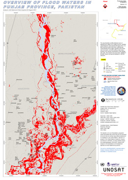
Overview of flood waters in Punjab province, Pakistan
Direitos autorais: RADARSAT-2 Data and Products © MacDonald, Dettwiler and Associates Ltd. (2013) - All Rights Reserved. RADARSAT is an official trademark of the Canadian Space Agency.
Map produced by UNITAR / UNOSAT
Information about the Product
Adquirida: 26/08/2013
Fonte: RADARSAT-2
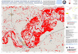
Overview of flood waters in Shikarpur and Sukkur Sistrict, Sindh Province, Pakistan
Direitos autorais: TerraSAR-X German Aerospace Center (DLR), 2013 Astrium/Services/Infoterra GmbH
RADARSAT-2 Data and Products © MacDonald, Dettwiler and Associates Ltd. (2013) - All Rights Reserved. RADARSAT is an official trademark of the Canadian Space Agency.
Map produced by UNITAR / UNOSAT
Information about the Product
Adquirida: 26/08/2013
Fonte: RADARSAT-2 & TerraSAR-X

Overview of flood waters in Sialkot and Narwol Districts
Direitos autorais: RADARSAT-2 Data and Products © MacDonald, Dettwiler and Associates Ltd. (2013) - All Rights Reserved. RADARSAT is an official trademark of the Canadian Space Agency.
Map produced by UNITAR / UNOSAT
Information about the Product
Adquirida: Pre-crisis: 17/10/2012
Post-crisis: 25/08/2013
Fonte: RADARSAT-2
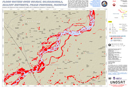
Flood waters over Gujrat, Gujranawala, Sialkot districts, Pujab Province, Pakistan
Direitos autorais: RADARSAT-2 Data and Products © MacDonald, Dettwiler and Associates Ltd. (2013) - All Rights Reserved. RADARSAT is an official trademark of the Canadian Space Agency.
Map produced by UNITAR / UNOSAT
Information about the Product
Adquirida: Pre-crisis: 17/10/2012
Post-crisis: 25/08/2013
Fonte: RADARSAT-2
 Voltar ao arquivo completo da Ativação

 English
 Spanish
 French
 Chinese
 Russian
 Portuguese


