Свернуть Последняя Активация

Charter activations

Flooding in Romania

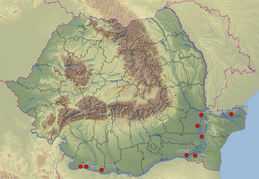
The floods which have hit Romania have taken their toll: more than 172,000 hectares of land and more than 30 areas have been affected. The worst hit have been Timis, Arad, Caras-Severin and Braila. In the areas of Buzua and Prahova, many places have also suffered from lanslides. Four people have been reported dead and one missing and 3400 people have been evcuated in the last few months.

The rains have devastated areas in more than 400 towns and 28 areas. More than 5300 houses, 8000 outhouses and tens of thousands of hectares of land have been destroyed.

The Prime Minister, Calin Popescu Tariceanu, made a statement this week saying that they will be considering solutions for the reconstruction of the 1000 houses in Timis and Caras-Severin which were totally destroyed by the floods. The next stage will be to put this bid out to tender to companies who will undertake the recontruction work. It has also been promised that the new houses will be finished before the start of the winter months.

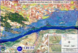
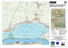
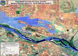
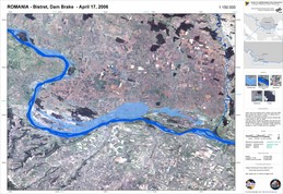
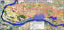
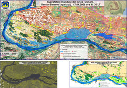
A dam broke on 16 April, causing severe flooding along the Danube in the area of Bistret and Rast.

Тип события:Floods
Место события:Romania
Date of Charter Activation:18/04/2006
Запрос на активацию поступил от:Romanian Space Agency
Менеждер проекта от:DLR

Products

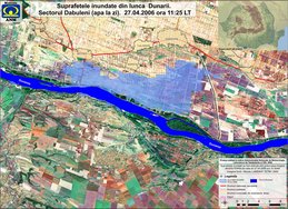
Dabuleni 27/04/06

Авторские права: NASA 2006, USGS 2000. Image processing, map created 28/04/2006 by ROSA, ANM, CRUTA (Romania) in the framework of GMES RISKEOS.

Information about the Product

Получено: 27/04/2006, 12/06/2000

Источник: MODIS, Landsat 7 ETM+

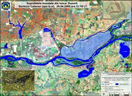
Calarasi 28/04/06

Авторские права: NASA 2006, USGS 2000. Image processing, map created 28/04/2006 by ROSA, ANM, CRUTA (Romania) in the framework of GMES RISKEOS.

Information about the Product

Получено: 28/04/2006, 12/06/2000

Источник: MODIS, Landsat 7 ETM+

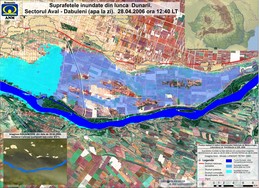
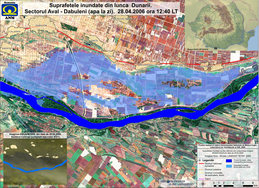
Aval Dabuleni 28/04/06

Авторские права: NASA 2006, USGS 2000. Image processing, map created 28/04/2006 by ROSA, ANM, CRUTA (Romania) in the framework of GMES RISKEOS.

Information about the Product

Получено: 28/04/2006, 12/06/2000

Источник: MODIS, Landsat 7 ETM+

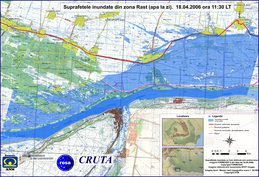
Rast Formosat Topographical Map showing flooded areas 18/04/06

Авторские права: NASA 2006, USGS 2000. Image processing, map created 28/04/2006 by ROSA, ANM, CRUTA (Romania) in the framework of GMES RISKEOS.

Information about the Product

Получено: 18/04/2006, 12/06/2000

Источник: MODIS, Landsat 7 ETM+

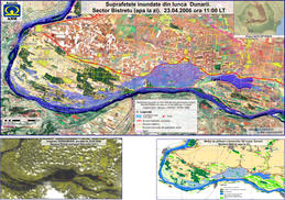
Bistret 23/04/06

Авторские права: NASA 2006, USGS 2000. Image processing, map created 28/04/2006 by ROSA, ANM, CRUTA (Romania) in the framework of GMES RISKEOS.
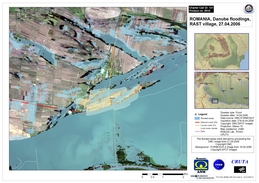
Information about the Product

Получено: 23/04/2006, 12/06/2000

Источник: MODIS, Landsat 7 ETM+

Aval Dabuleni 28/04/06

Авторские права: NASA 2006, USGS 2000. Image processing, map created 28/04/2006 by ROSA, ANM, CRUTA (Romania) in the framework of GMES RISKEOS.

Information about the Product

Получено: 28/04/2006, 12/06/2000

Источник: MODIS, Landsat 7 ETM+

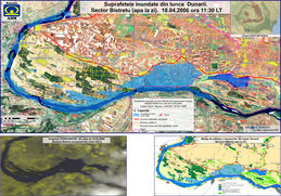
Bistret 18/04/06

Авторские права: NASA 2006, USGS 2000. Image processing, map created 28/04/2006 by ROSA, ANM, CRUTA (Romania) in the framework of GMES RISKEOS.

Information about the Product

Получено: 18/04/2006, 12/06/2000

Источник: MODIS, Landsat 7 ETM+

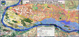
Bistret 01/05/06

Авторские права: NASA 2006, USGS 2000. Image processing, map created 02/05/2006 by ROSA, ANM, CRUTA (Romania) in the framework of GMES RISKEOS.

Information about the Product

Получено: 01/05/2006, 12/06/2000

Источник: MODIS, Landsat 7 ETM+

Rast Formosat Landsat 18/04/06

Авторские права: FORMOSAT 2006. Image processing, map created 23/04/2006 by ROSA, ANM, CRUTA (Romania) in the framework of GMES RISKEOS.

Information about the Product

Получено: 18/04/2006, 12/06/2000

Источник: FORMOSAT-2, Landsat 7 ETM+

Rast Spot 19/04/2006 English

Авторские права: CNES 2006 Image processing, map created 25/04/2006 by ROSA, ANM, CRUTA (Romania) in the framework of GMES RISKEOS.

Information about the Product

Получено: 23/04/2006

Источник: Spot

Bistret 25/04/06

Авторские права: NASA 2006, USGS 2000. Image processing, map created 28/04/2006 by ROSA, ANM, CRUTA (Romania) in the framework of GMES RISKEOS.

Information about the Product

Получено: 25/04/2006, 12/06/2000

Источник: MODIS, Landsat 7 ETM+

Romania Flood Bistret Modis

Авторские права: NASA 2006, USGS 2000 Image processing, map created 19/04/2006 by DLR in the framework of GMES RISKEOS.

Information about the Product

Получено: 17/04/2006, 12/06/2000 Flooded area around Bistret and Rastu.

Источник: MODIS, Landsat 7 ETM+

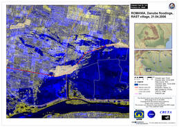
Rast Ers 21/04/2006 EN

Авторские права: ESA 2006. Image processing, map created 23/04/2006 by ROSA, ANM, CRUTA (Romania) in the framework of GMES RISKEOS.

Information about the Product

Получено: 21/04/2006

Источник: ERS

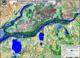
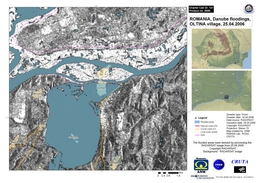
Oltina 27/04/06

Авторские права: NASA 2006, USGS 2000. Image processing, map created 28/04/2006 by ROSA, ANM, CRUTA (Romania) in the framework of GMES RISKEOS.

Information about the Product

Получено: 27/04/2006, 12/06/2000

Источник: MODIS, Landsat 7 ETM+

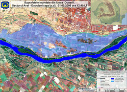
Aval Dabuleni 01/05/06

Авторские права: NASA 2006, USGS 2000. Image processing, map created 02/05/2006 by ROSA, ANM, CRUTA (Romania) in the framework of GMES RISKEOS.

Information about the Product

Получено: 01/05/2006, 12/06/2000

Источник: MODIS, Landsat 7 ETM+

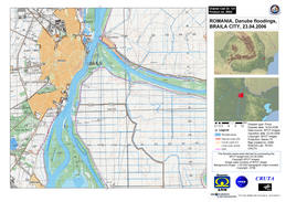
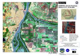
Braila Spot 23/04/06

Авторские права: CNES 2006 Image processing, map created 25/04/2006 by ROSA, ANM, CRUTA (Romania) in the framework of GMES RISKEOS.

Information about the Product

Получено: 23/04/2006

Источник: Spot

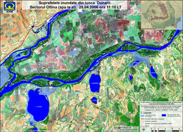
Oltina 28/04/06

Авторские права: NASA 2006, USGS 2000. Image processing, map created 28/04/2006 by ROSA, ANM, CRUTA (Romania) in the framework of GMES RISKEOS.

Information about the Product

Получено: 28/04/2006, 12/06/2000

Источник: MODIS, Landsat 7 ETM+

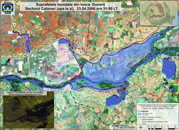
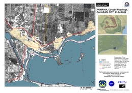
Calarasi 23/04/06

Авторские права: NASA 2006, USGS 2000. Image processing, map created 28/04/2006 by ROSA, ANM, CRUTA (Romania) in the framework of GMES RISKEOS.

Information about the Product

Получено: 23/04/2006, 12/06/2000

Источник: MODIS, Landsat 7 ETM+

Rast Radar Mozaic 21/04/2006

Авторские права: CSA 2006 Image processing, map created 26/04/2006 by ROSA, ANM, CRUTA (Romania) in the framework of GMES RISKEOS.

Information about the Product

Получено: 25/04/2006

Источник: RADARSAT-1

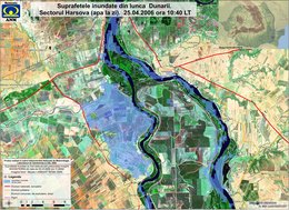
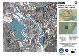
Harsova 25/04/06

Авторские права: NASA 2006, USGS 2000. Image processing, map created 28/04/2006 by ROSA, ANM, CRUTA (Romania) in the framework of GMES RISKEOS.

Information about the Product

Получено: 25/04/2006, 12/06/2000

Источник: MODIS, Landsat 7 ETM+

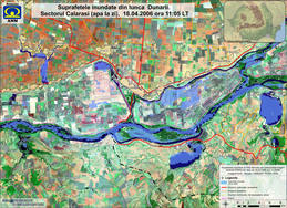
Calarasi 18/04/06

Авторские права: NASA 2006, USGS 2000. Image processing, map created 28/04/2006 by ROSA, ANM, CRUTA (Romania) in the framework of GMES RISKEOS.

Information about the Product

Получено: 18/04/2006, 12/06/2000

Источник: MODIS, Landsat 7 ETM+

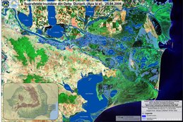
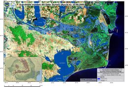
Delta Dunarii 25/04/06

Авторские права: NASA 2006, USGS 2000. Image processing, map created 28/04/2006 by ROSA, ANM, CRUTA (Romania) in the framework of GMES RISKEOS.

Information about the Product

Получено: 25/04/2006, 12/06/2000

Источник: MODIS, Landsat 7 ETM+

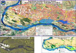
Bistret 15/04/06

Авторские права: NASA 2006, USGS 2000. Image processing, map created 28/04/2006 by ROSA, ANM, CRUTA (Romania) in the framework of GMES RISKEOS.

Information about the Product

Получено: 15/04/2006, 12/06/2000

Источник: MODIS, Landsat 7 ETM+

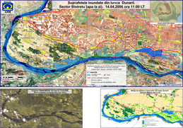
Bistret 14/04/06

Авторские права: NASA 2006, USGS 2000. Image processing, map created 28/04/2006 by ROSA, ANM, CRUTA (Romania) in the framework of GMES RISKEOS.

Information about the Product

Получено: 14/04/2006, 12/06/2000

Источник: MODIS, Landsat 7 ETM+

Hot Spot Inudatii Romani

Авторские права: CNES 2006 Image processing, map created 25/04/2006 by ROSA, ANM, CRUTA (Romania) in the framework of GMES RISKEOS.

Information about the Product

Получено: 23/04/2006

Источник: Spot

Bistret 21/04/06

Авторские права: NASA 2006, USGS 2000. Image processing, map created 28/04/2006 by ROSA, ANM, CRUTA (Romania) in the framework of GMES RISKEOS.

Information about the Product

Получено: 21/04/2006, 12/06/2000

Источник: MODIS, Landsat 7 ETM+

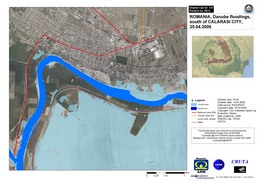
Calarasi Radar 25/04/06

Авторские права: CSA 2006 Image processing, map created 26/04/2006 by ROSA, ANM, CRUTA (Romania) in the framework of GMES RISKEOS.

Information about the Product

Получено: 25/04/2006

Источник: RADARSAT-1

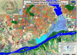
Spantov 28/04/06

Авторские права: NASA 2006, USGS 2000. Image processing, map created 28/04/2006 by ROSA, ANM, CRUTA (Romania) in the framework of GMES RISKEOS.

Information about the Product

Получено: 28/04/2006, 12/06/2000

Источник: MODIS, Landsat 7 ETM+

Harsova Radar 25/04/06

Авторские права: CSA 2006 Image processing, map created 26/04/2006 by ROSA, ANM, CRUTA (Romania) in the framework of GMES RISKEOS.

Information about the Product

Получено: 25/04/2006

Источник: RADARSAT-1

Bistret 17/04/06

Авторские права: NASA 2006, USGS 2000. Image processing, map created 28/04/2006 by ROSA, ANM, CRUTA (Romania) in the framework of GMES RISKEOS.

Information about the Product

Получено: 17/04/2006, 12/06/2000

Источник: MODIS, Landsat 7 ETM+

Oltina Radar 25/04/06

Авторские права: CSA 2006 Image processing, map created 26/04/2006 by ROSA, ANM, CRUTA (Romania) in the framework of GMES RISKEOS.

Information about the Product

Получено: 25/04/2006

Источник: RADARSAT-1

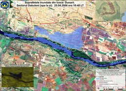
Dabuleni 25/04/06

Авторские права: NASA 2006, USGS 2000. Image processing, map created 28/04/2006 by ROSA, ANM, CRUTA (Romania) in the framework of GMES RISKEOS.

Information about the Product

Получено: 25/04/2006, 12/06/2000

Источник: MODIS, Landsat 7 ETM+

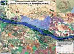
Dabuleni 26/04/06

Авторские права: NASA 2006, USGS 2000. Image processing, map created 28/04/2006 by ROSA, ANM, CRUTA (Romania) in the framework of GMES RISKEOS.

Information about the Product

Получено: 26/04/2006, 12/06/2000

Источник: MODIS, Landsat 7 ETM+

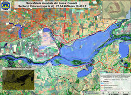
Calarasi 25/04/06

Авторские права: NASA 2006, USGS 2000. Image processing, map created 28/04/2006 by ROSA, ANM, CRUTA (Romania) in the framework of GMES RISKEOS.

Information about the Product

Получено: 25/04/2006, 12/06/2000

Источник: MODIS, Landsat 7 ETM+

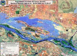
Bistret 26/04/06

Авторские права: NASA 2006, USGS 2000. Image processing, map created 28/04/2006 by ROSA, ANM, CRUTA (Romania) in the framework of GMES RISKEOS.

Information about the Product

Получено: 26/04/2006, 12/06/2000

Источник: MODIS, Landsat 7 ETM+

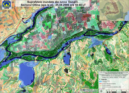
Oltina 25/04/06

Авторские права: NASA 2006, USGS 2000. Image processing, map created 28/04/2006 by ROSA, ANM, CRUTA (Romania) in the framework of GMES RISKEOS.

Information about the Product

Получено: 25/04/2006, 12/06/2000

Источник: MODIS, Landsat 7 ETM+

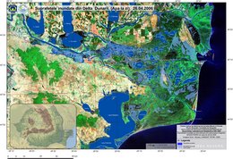
Delta Dunarii 26/04/06

Авторские права: NASA 2006, USGS 2000. Image processing, map created 28/04/2006 by ROSA, ANM, CRUTA (Romania) in the framework of GMES RISKEOS.

Information about the Product

Получено: 26/04/2006, 12/06/2000

Источник: MODIS, Landsat 7 ETM+

Spot Braila Landsat 23/04/2006

Авторские права: ESA 2006. Image processing, map created 23/04/2006 by ROSA, ANM, CRUTA (Romania) in the framework of GMES RISKEOS.

Information about the Product

Получено: 23/04/2006

Источник: ERS-2

Calarasi Radar over aerial photo 25 04

Авторские права: CSA 2006 Image processing, map created 26/04/2006 by ROSA, ANM, CRUTA (Romania) in the framework of GMES RISKEOS.

Information about the Product

Получено: 25/04/2006

Источник: RADARSAT-1

Rast Bistret Dmc Formosat 27/04/06

Авторские права: DMC 2006, Spotimage 2006 Image processing, map created 28/04/2006 by ROSA/CRUTA in the framework of GMES RISKEOS.

Information about the Product

Получено: 27/04/2006, 18/04/2000 Flooded area around Bistret and Rastu.

Источник: Formosat, DMC

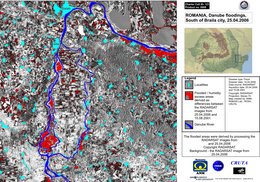
Radar Sud Braila Change 25/04/06

Авторские права: NASA 2006, USGS 2000. Image processing, map created 28/04/2006 by ROSA, ANM, CRUTA (Romania) in the framework of GMES RISKEOS.

Information about the Product

Получено: 25/04/2006, 12/06/2000

Источник: MODIS, Landsat 7 ETM+

Delta Dunarii 27/04/06

Авторские права: NASA 2006, USGS 2000. Image processing, map created 28/04/2006 by ROSA, ANM, CRUTA (Romania) in the framework of GMES RISKEOS.

Information about the Product

Получено: 27/04/2006, 12/06/2000

Источник: MODIS, Landsat 7 ETM+

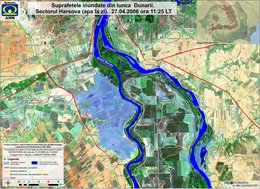
Harsova 27/04/06

Авторские права: NASA 2006, USGS 2000. Image processing, map created 28/04/2006 by ROSA, ANM, CRUTA (Romania) in the framework of GMES RISKEOS.

Information about the Product

Получено: 27/04/2006, 12/06/2000

Источник: MODIS, Landsat 7 ETM+

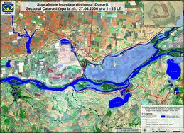
Calarasi 27/04/06

Авторские права: NASA 2006, USGS 2000. Image processing, map created 28/04/2006 by ROSA, ANM, CRUTA (Romania) in the framework of GMES RISKEOS.

Information about the Product

Получено: 27/04/2006, 12/06/2000

Источник: MODIS, Landsat 7 ETM+

Вернуться к полному архиву активаций