Charter activations
Floods in Romania
Following heavy rains, Romania was affected by serious flooding. The toll of the floods was dramatic: more than 172,000 hectares of land and 30 areas were affected, the worst damage having been seen in Timis, Arad, Caras-Severin and Braila. Many areas in the Buzua and Prahova provinces suffered landslides. Four people were reported dead, one reported missing and 3400 were evacuated during the month of May. The rains devastated areas in more than 400 towns in 28 areas; more than 5300 houses, 8000 outhouses and ten of thousands of hectares of land were damaged.
| Type of Event: | Flood |
| Location of Event: | Romania |
| Date of Charter Activation: | 31/05/2005 |
| Charter Requestor: | European Commission Civil Protection and Environment Unit |
| Project Management: | DLR |
Products

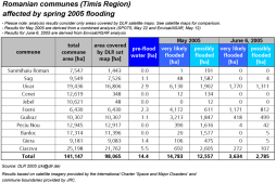
The table contains an analysis of the flooded areas in the Romanian commmunes as they are shown in the map. Please note: analysis results refer only to those parts of communes which are contained in the satellite map
Copyright: Analysis : DLR 8 June 2005, updated 21 June 2005
Information about the Product
Acquired: 21/06/2005
Source: Envisat ASAR and SPOT 5, communal boudaries provided by JRC.

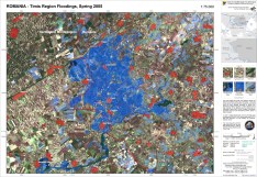
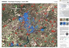
DLR flood map for the situation - Timis region (1:75.000) Envisat ASAR Narrow Swath and SPOT 5 data were analysed. The map displays the combined analysis results.
Copyright: SPOT CNES 2005, distributed by Spot Image ENVISAT ASAR ESA 2005
Information about the Product
Acquired: 07/06/2005
Source: Envisat-ASAR, Spot 5

DLR flood map for the situation in May 2005 (using Envisat-ASAR and SPOT5) - Timis region (1:75.000)
Envisat ASAR Narrow Swath and SPOT 5 data were analysed. The map displays the combined analysis results
Copyright: SPOT CNES 2005, distributed by Spot Image ENVISAT ASAR ESA 2005
Information about the Product
Acquired: 21/06/2005
Source: Image processing and map creation 21/06/2005 by DLR
 Back to the full activation archive

 English
 Spanish
 French
 Chinese
 Russian
 Portuguese


