Charter activations
罗马尼亚洪水
暴雨使罗马尼亚遭受严重洪灾。洪水造成了巨大损失:17.2万公顷土地和30个地区受灾,受灾最严重的是蒂米什、阿拉德、卡拉什-赛弗和布勒伊拉。布左和普拉霍瓦省的许多地区发生滑坡。据报道,5月期间有3人死亡,1 人失踪,3400人撤离。暴雨使28个地区的400个城镇受灾;5300多间房屋、8000多个室外建筑物和数千公顷土地遭到毁坏。
| 事件类型: | 洪水 |
| 事件地点: | 罗马尼亚 |
| 启动宪章的日期: | 2005年5月31日 |
| 宪章要求者: | 欧洲委员会民事保护与环境部门 |
| 项目经理: | DLR |
Products

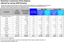
The table contains an analysis of the flooded areas in the Romanian commmunes as they are shown in the map. Please note: analysis results refer only to those parts of communes which are contained in the satellite map
版权: Analysis : DLR 8 June 2005, updated 21 June 2005
Information about the Product
已获得: 21/06/2005
源: Envisat ASAR and SPOT 5, communal boudaries provided by JRC.

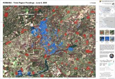
DLR flood map for the situation - Timis region (1:75.000) Envisat ASAR Narrow Swath and SPOT 5 data were analysed. The map displays the combined analysis results.
版权: SPOT CNES 2005, distributed by Spot Image ENVISAT ASAR ESA 2005
Information about the Product
已获得: 07/06/2005
源: Envisat-ASAR, Spot 5

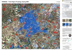
DLR flood map for the situation in May 2005 (using Envisat-ASAR and SPOT5) - Timis region (1:75.000)
Envisat ASAR Narrow Swath and SPOT 5 data were analysed. The map displays the combined analysis results
版权: SPOT CNES 2005, distributed by Spot Image ENVISAT ASAR ESA 2005
Information about the Product
已获得: 21/06/2005
源: Image processing and map creation 21/06/2005 by DLR
 返回完整的响应档案

 English
 Spanish
 French
 Chinese
 Russian
 Portuguese


