Charter activations
Flood in United Kingdom
Heavy rainfall has caused flooding and landslides in Scotland, with some areas receiving more than two weeks worth of rain in two days.
As of 9 October, the Scottish Environment Protection Agency (SEPA) had 8 flood alerts in place, and 51 flood warnings. Two severe flood warnings were issued for Perth and Aviemore.
Though no casualties or injuries have been reported, the flooding has caused disruption throughout the country with the west and north particularly affected. Residents have been warned not to travel unless necessary and to avoid flooded areas.
14 people were rescued in Argyll and Bute when landslides on a road trapped them in their cars. Roads and railways lines are disrupted by both landslides and floods.
The heavy rainfall began on 6 October and continued through the day afterwards. Though the rain weakened on 8 October, more rain is expected in the following days.
| Тип события: | Floods, landslides |
| Место события: | United Kingdom |
| Date of Charter Activation: | 2023-10-06 |
| Время активации Хартии: | 17:53 |
| TЧасовой пояс в районе активации Хартии: | UTC+01:00 |
| Запрос на активацию поступил от: | Scottish Environment Protection Agency (SEPA) |
| Номер активации: | 841 |
| Менеждер проекта от: | Dominic Habron (Scottish Environment Protection Agency) |
| act-value-adders: | University of Stirling Dr Cristian Silva Perez (University of Stirling) Alessandro Novellino (British Geological Survey) |
Products

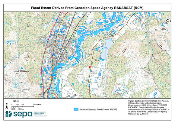
River Spey flooding
Авторские права: RADARSAT Constellation Mission Imagery © Government of Canada (2023) - RADARSAT is an official mark of the Canadian Space Agency
Map produced by The Scottish Environment Protection Agency (Sepa)
Information about the Product
Получено: 08/10/2023
Источник: RCM
Категория: Delineation Map

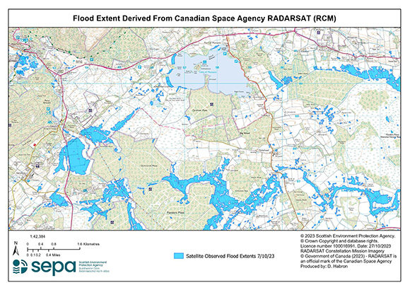
Areas affected from flooding from river forth
Авторские права: RADARSAT Constellation Mission Imagery © Government of Canada (2023) - RADARSAT is an official mark of the Canadian Space Agency
Map produced by The Scottish Environment Protection Agency (Sepa)
Information about the Product
Получено: 07/10/2023
Источник: RCM
Категория: Delineation Map
Quickviews
Quickviews are produced for illustration purposes only and do not contain any verified analysis of the disaster.


Sentinel-1 images over Scotland, South of Carnigorns National Park, showing large differences in backscatter over flooded areas (water surfaces appears black in a radar image). The Earn and Tay rivers show abnormally high water levels, along with several lochs in the area.
Copyrights: Contains modified Copernicus Sentinel data (2023).
Information about the Quickview
Acquired: 2023-10-08 / 2023-10-03
Source(s): Sentinel-1 / Sentinel-1
 Вернуться к полному архиву активаций

 English
 Spanish
 French
 Chinese
 Russian
 Portuguese


