 English
 Spanish
 French
 Chinese
 Russian
 Portuguese
 Последняя Активация
Charter activations
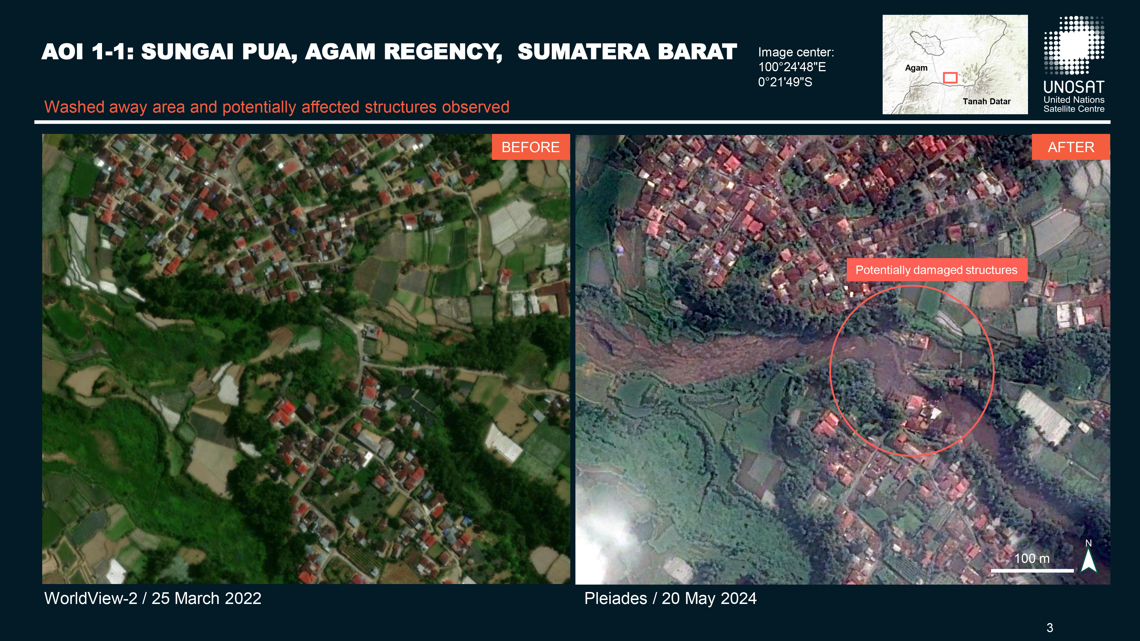
Flood in Sumatra, Indonesia
Heavy rains triggered flash floods and caused torrents of cold lava and mud to flow down a volcano's slopes on Indonesia's Sumatra island, killing at least 41 people and leaving more than a dozen others missing.
The National Disaster Mitigation Agency (BNPB) deployed around 400 personnel, including rescuers, police, and military to search for the missing people and organise evacuations of the worst affected areas. Several emergency management measures were put in place, including restoring road access, removing landslide material, and coordinating with regional organizations.
The cold lava flow, known in Indonesia as a lahar, came from Mount Marapi, one of Sumatra's most active volcanoes. More than 20 people were killed when Marapi erupted in December. A series of eruptions have followed since.
Nearby Sulawesi has also been badly affected
Related resources
Sentinel Asia activation for flood in Sumatra, Indonesia| Тип события: | Floods |
| Место события: | Sumatra |
| Date of Charter Activation: | 2024-05-14 |
| Время активации Хартии: | 00:42 |
| TЧасовой пояс в районе активации Хартии: | UTC+09:00 |
| Запрос на активацию поступил от: | ADRC on behalf of National Research and Innovation Agency (BRIN) |
| Номер активации: | 879 |
| Менеждер проекта от: | Anjar Ilham Pambudi (National Research and Innovation Agency (BRIN)) |
| act-value-adders: | National Research and Innovation Agency Indonesia (BRIN) Jakrapong Tawala (UNITAR) |
Products
Mudslide / Lahar impact in Canduang, Agam Metropolitan, Indonesia
Авторские права: VRSS-2 © ABAE (2024). All Rights Reserved.
Includes Pleiades material © CNES (2024), Distribution Airbus DS.
Map produced by UNITAR / UNOSAT
Information about the Product
Получено: VRSS-2: 17/05/2024
Pleiades: 23/05/2024
Источник: VRSS-2 / Pleiades
Категория: Grading Map
Pre- and Post-Disaster Situation Flood/landslide in Tanah Datar Regency, West Sumatra
Авторские права: Includes Pleiades material © CNES (2024), Distribution Airbus DS.
SPOT-7: Includes material © AIRBUS DS (2024)
Map produced by UN-SPIDER
Information about the Product
Получено: Pleiades: 17/05/2024
SPOT-7: 17/05/2024
Источник: Pleiades / SPOT-7
Категория: Delineation Map
Pre- and Post-Disaster Situation Flood/landslide in Tanah Datar Regency, West Sumatra
Авторские права: SPOT-7: Includes material © AIRBUS DS (2024)
Includes Pleiades material © CNES (2024), Distribution Airbus DS.
Map produced by UN-SPIDER
Information about the Product
Получено: SPOT-7: 17/05/2024
Pleiades: 17/05/2024
Источник: SPOT-7 / Pleiades
Категория: Delineation Map
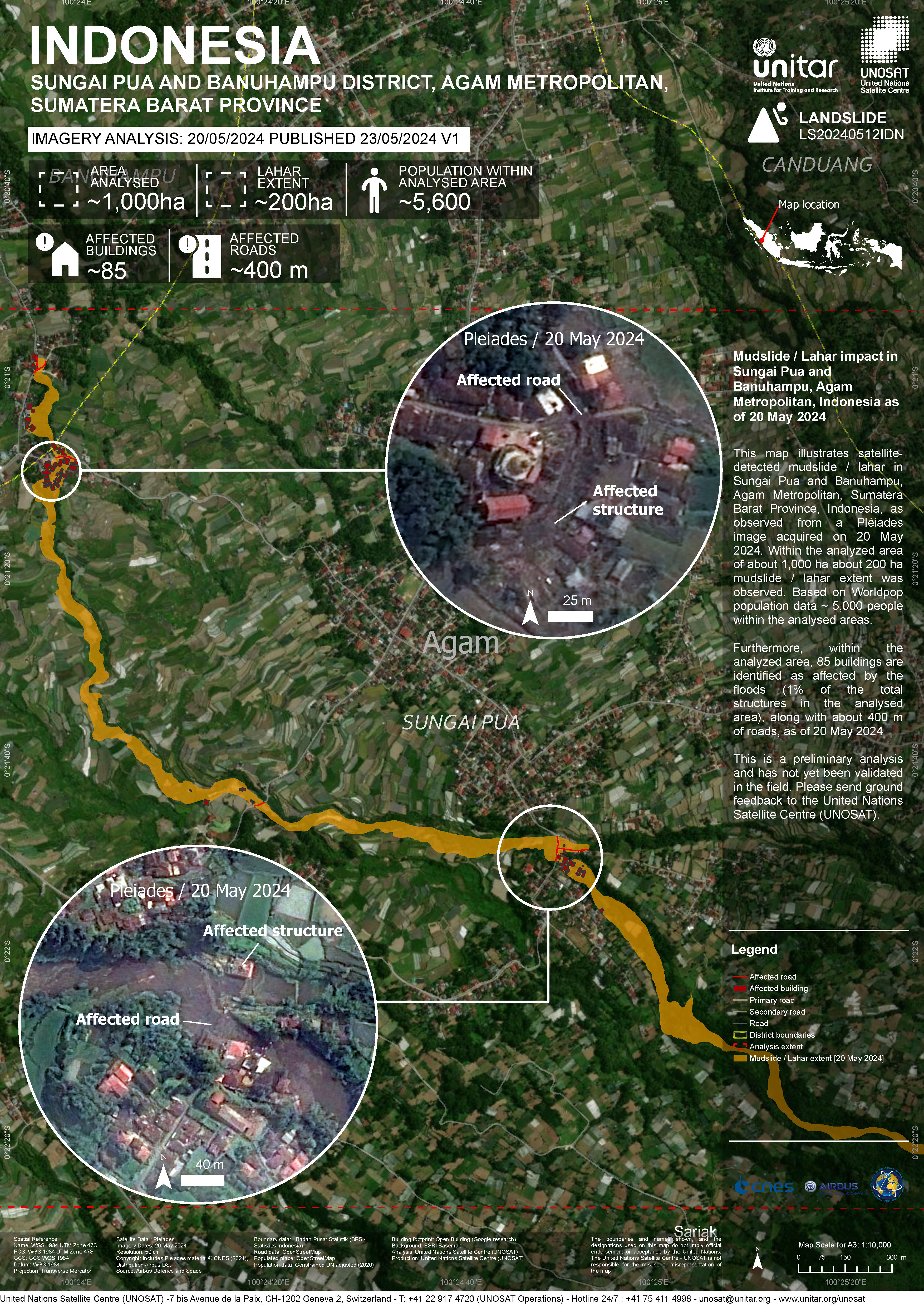
Preliminary satellite-derived impact assessment, Agam Regency, Sumatera Barat, Indonesia
Download full report
Авторские права: Includes Pleiades material © CNES (2024), Distribution Airbus DS.
Report produced by UNITAR / UNOSAT
Information about the Product
Получено: 20/05/2024
Источник: Pleiades
Категория: Dossier
 Вернуться к полному архиву активаций

