Minimizar Latest Activation

Charter activations

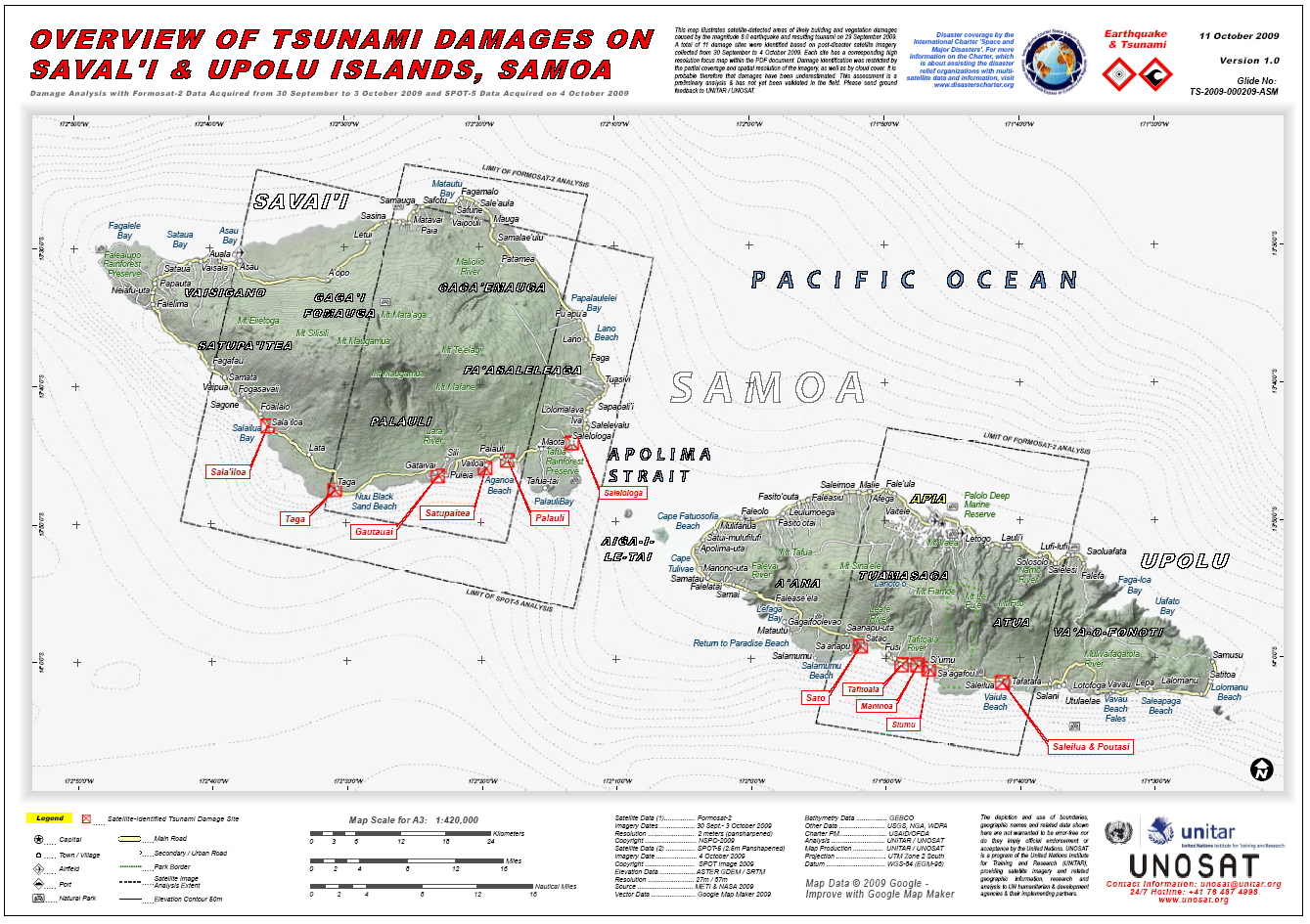
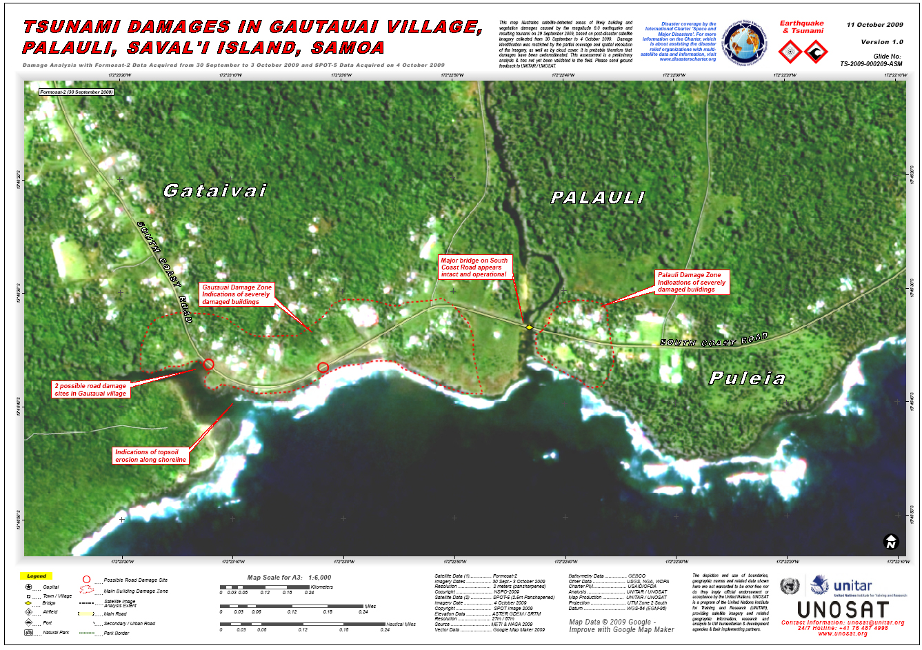
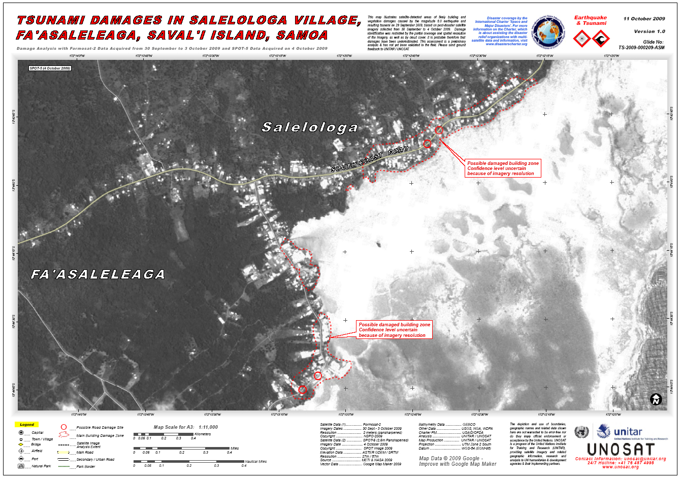
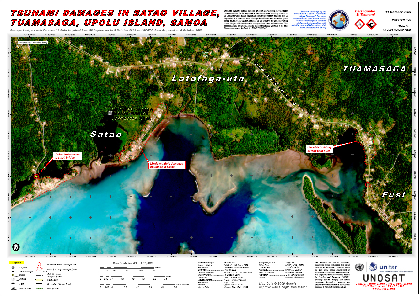
Tsunami in Samoa Islands

More than 120 people died when a series of tsunamis, triggered by a magnitude-8.0 earthquake, swept across the South Pacific.
The south coast of Samoa's main island Upolu has been devastated.

Tipo de evento:Tsunami
Local do evento:Samoa Islands
Data da Ativação da Carta:30/09/2009
Requisitante da Carta:UNOOSA on behalf of UNOCHA/Pacific
Gerenciamento de projeto:Office of U.S. Foreign Disaster Assistance

Products

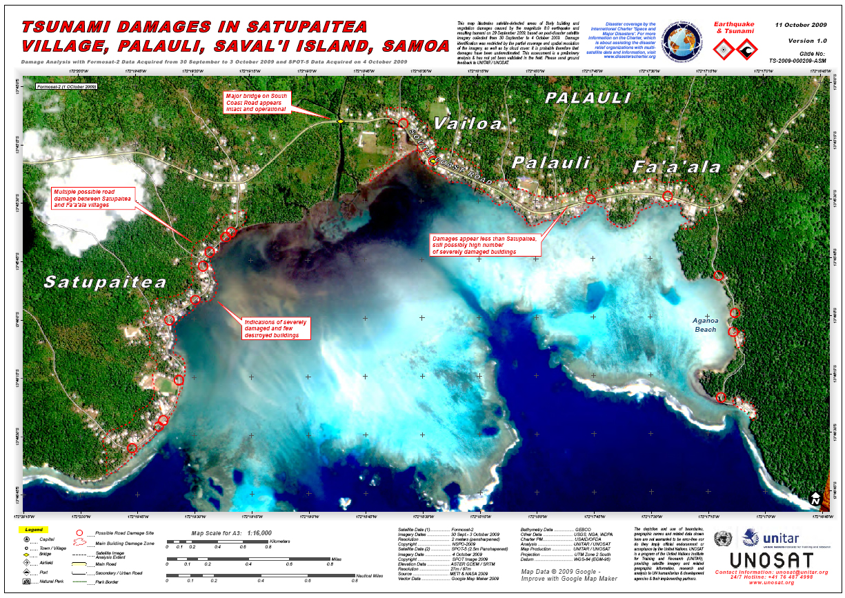
Tsunami damages in Satupaiteia village, Palauli, Saval'i island, Samoa.

Direitos autorais: NSPO-2009, SPOT Image 2009, USGS, NGA, WDPA.
Image processing, map created by UNITAR / UNOSAT

Information about the Product

Adquirida: Formosat-2: 30/09/2009 to 03/10/2009
SPOT-5: 04/10/2009

Fonte: Formosat-2, SPOT-5

Overview of tsunami damages on Tutuila Island, American Samoa.
Areas of likely building and vegetation damages.

Direitos autorais: USGS, METI & NASA
Image processing, map created 20/10/2009 by UNITAR / UNOSAT.

Information about the Product

Adquirida: 2-3/10/2009

Fonte: Formosat-2

Tsunami damages in Poloa Village, Lealataua, Tutuila Island, American Samoa.

Direitos autorais: USGS, METI & NASA 2009
Image processing, map created 20/10/2009 by UNITAR / UNOSAT.

Information about the Product

Adquirida: 2-3/10/2009

Fonte: Formosat-2

Tsunami damages in Se'etaga Village, Lealataua, Tutuila Island, American Samoa.

Direitos autorais: USGS, METI & NASA 2009
Image processing, map created 20/10/2009 by UNITAR / UNOSAT.

Information about the Product

Adquirida: 2-3/10/2009

Fonte: Formosat-2

Tsunami damags to port facility in Fagatogo, Ma'oputasi, Tutuila Island, American Samoa.

Direitos autorais: USGS, METI & NASA 2009
Image processing, map created 20/10/2009 by UNITAR / UNOSAT.

Information about the Product

Adquirida: 2-3/10/2009

Fonte: Formosat-2

Overview of tsunami damages on Saval'i & Upolu Islands, Samoa.

Direitos autorais: METI & NASA 2009
SPOT Image 2009
Image processing, map created 11/10/2009 by UNITAR / UNOSAT.

Information about the Product

Adquirida: 30/09 – 3/10/2009

Fonte: Formosat-2, SPOT-5

Tsunami damages in Gautauai Village, Palauli, Saval'i Island, Samoa.

Direitos autorais: METI & NASA 2009
SPOT Image 2009
Image processing, map created 11/10/2009 by UNITAR / UNOSAT.

Information about the Product

Adquirida: 30/09/2009 – 4/10/2009

Fonte: Formosat-2, SPOT-5

Tsunami damages in Salelologa Village, Fa'asaleleaga, Saval'i Island, Samoa.

Direitos autorais: METI & NASA 2009
SPOT Image 2009
Image processing, map created 11/10/2009 by UNITAR / UNOSAT.

Information about the Product

Adquirida: 30/09/2009 – 4/10/2009

Fonte: Formosat-2, SPOT-5

Tsunami damages in Satao Village, Tuamasaga, Upolu Island, Samoa.

Direitos autorais: METI & NASA 2009
SPOT Image 2009
Image processing, map created 11/10/2009 by UNITAR / UNOSAT.

Information about the Product

Adquirida: 30/09/2009 – 04/10/2009

Fonte: Formosat-2, SPOT-5

Voltar ao arquivo completo da Ativação