 English
 Spanish
 French
 Chinese
 Russian
 Portuguese
 Latest Activation
Charter activations
Tsunami in Indonesia
A tsunami hit coastal towns on Indonedia's Sunda Strait killing at least 228, injuring around 1000, and displacing 12,000 people. The giant waves struck without warning after an undersea landslide from the Anak Krakatau volcano caused the surges.
Many hundreds of buildings were destroyed as the water swept them away along with cars and trees. The waves hit popular tourist destinations during a local holiday meaning the area was busier than usual.
Rescue teams have deployed but efforts to reach affected areas were initially hampered by damaged and blocked roads. The roads have since been cleared to allow aid and heavy lifting equipment through to begin the search for missing people.
The disaster management agency has warned people to stay away from the coastline amid fears of another tsunami.
Related News and Resources
| Tipo de evento: | Ocean Wave |
| Local do evento: | Indonesia |
| Data da Ativação da Carta: | 2018-12-23 |
| Tempo de Ativação da Carta: | 04:55 |
| Zona de Tempo da Ativação da Carta: | UTC+01:00 |
| Requisitante da Carta: | United Nations Office for Outer Space Affairs (UNOOSA) on behalf of LAPAN (UN-SPIDER RSO) UNITAR on behalf of UNESCAP |
| ID da Ativação: | 594 |
| Gerenciamento de projeto: | Indonesian National Institute of Aeronautics and Space (LAPAN) |
Products
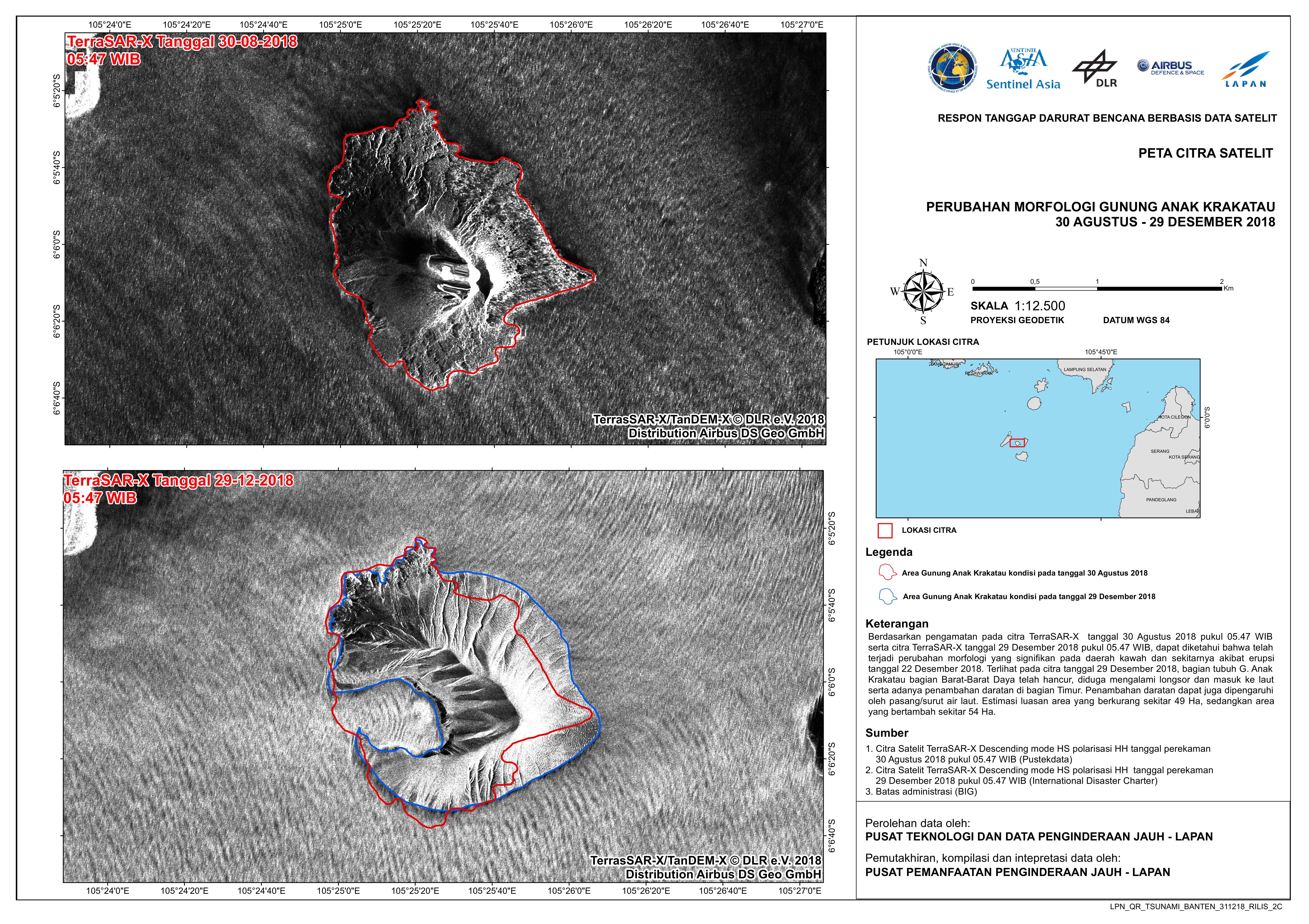
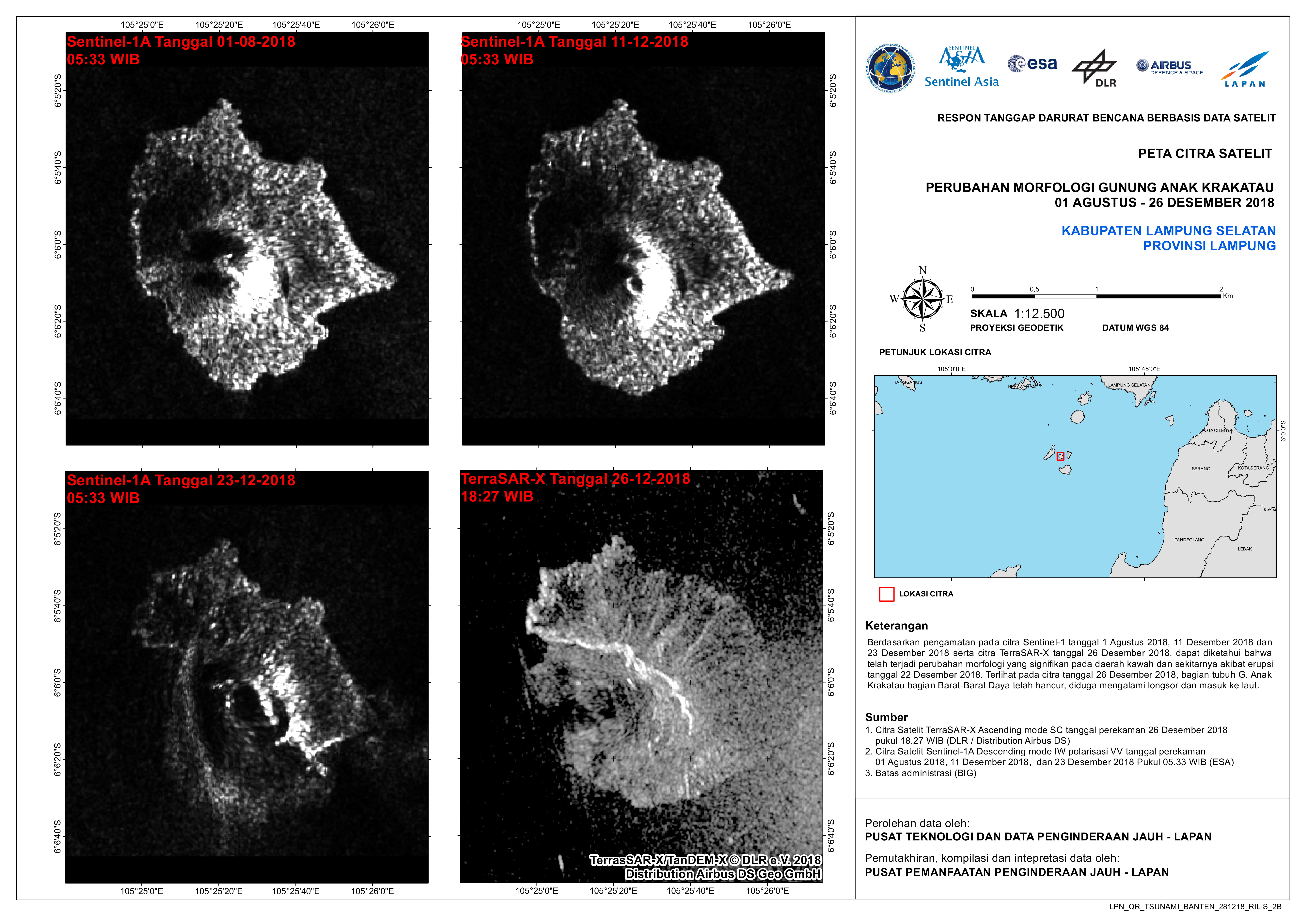
Assessment of Anak Krakatau, Indonesia
Direitos autorais: Sentinel-1 © Copernicus Sentinel data (2019)
TerraSAR-X © DLR e. V. 2019, Distribution: Airbus DS Geo GmbH
Map produced by LAPAN
Information about the Product
Adquirida: TerraSAR-X: 26/12/2018
Sentinel-1: 01/08/2018, 11/12/2018 and 23/12/2018
Fonte: TerraSAR-X and Sentinel-1
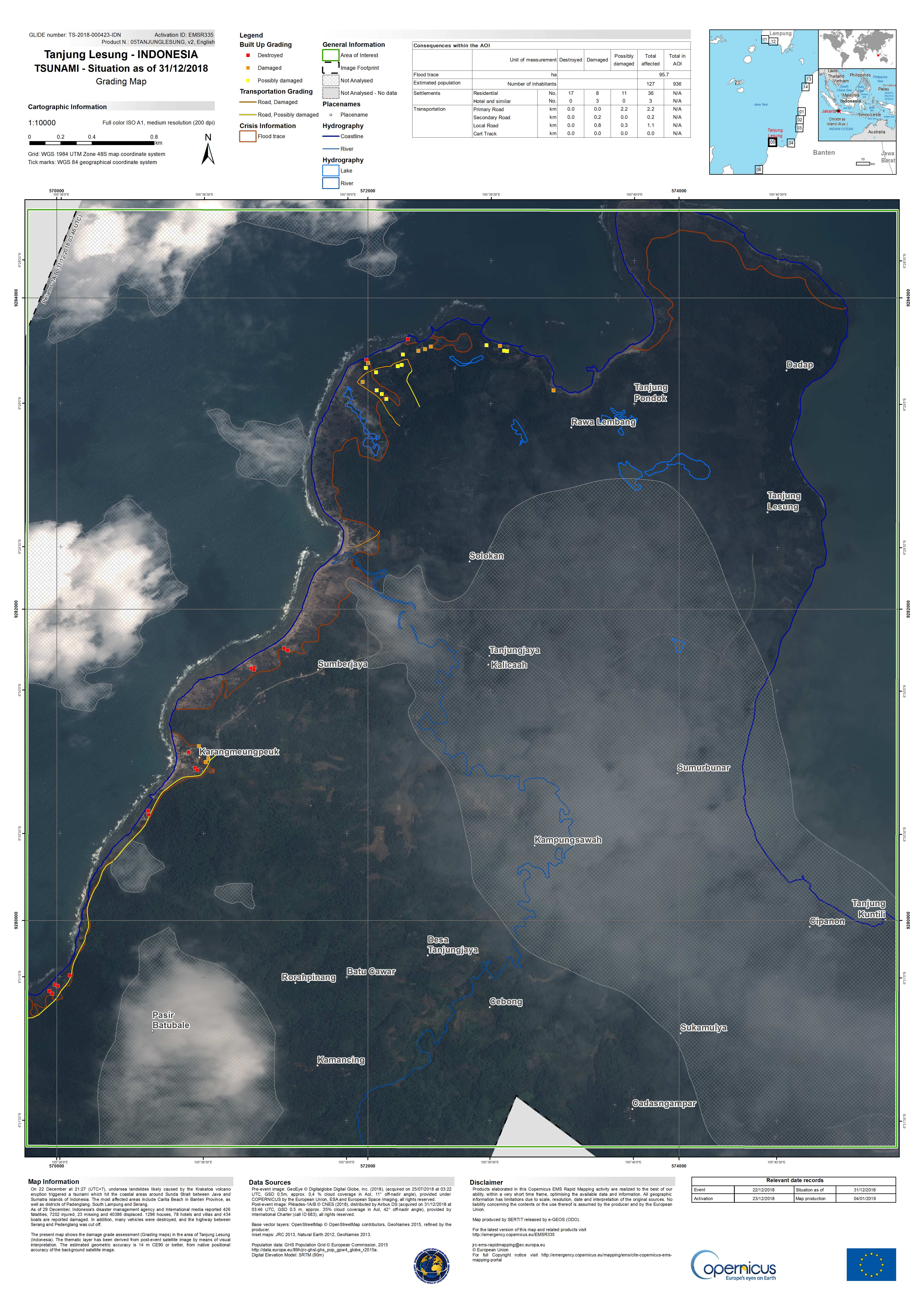
Damage grade assessment of Tanjung Lesung, Indonesia
Direitos autorais: GeoEye © DigitalGlobe Inc.
Pleiades © CNES (2018) - Distribution: Airbus Defence and Space, all rights reserved
Map produced by Copernicus EMS
Information about the Product
Adquirida: GeoEye: 25/07/2018
Pleiades: 31/12/2018
Fonte: GeoEye / Pleiades
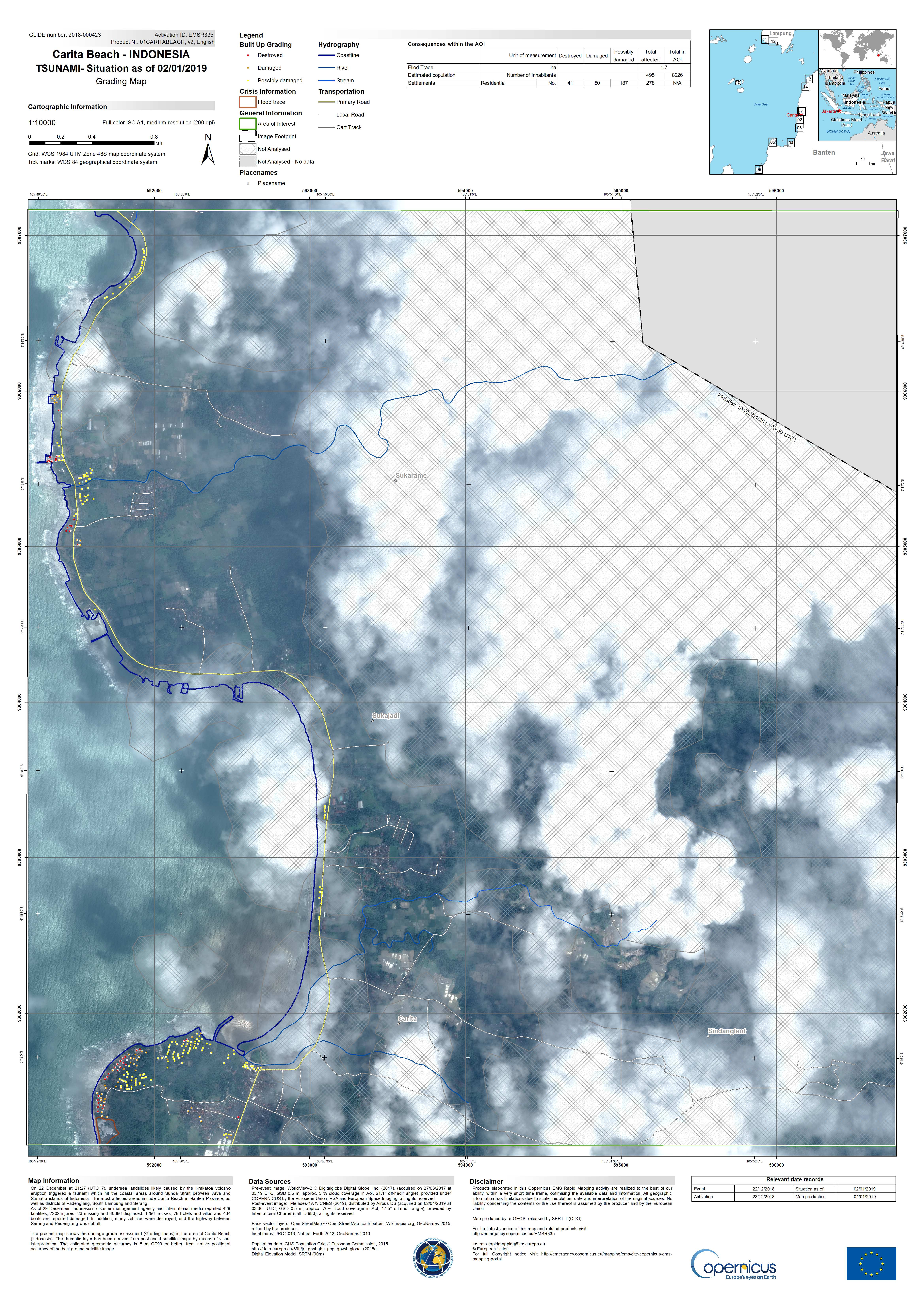
Damage grade assessment of Carita Beach, Indonesia
Direitos autorais: WorldView-2 © DigitalGlobe Inc.
Pleiades © CNES (2019) - Distribution: Airbus Defence and Space, all rights reserved
Map produced by Copernicus EMS
Information about the Product
Adquirida: WorldView-2: 27/03/2017
Pleiades: 02/01/2019
Fonte: WorldView-2 / Pleiades
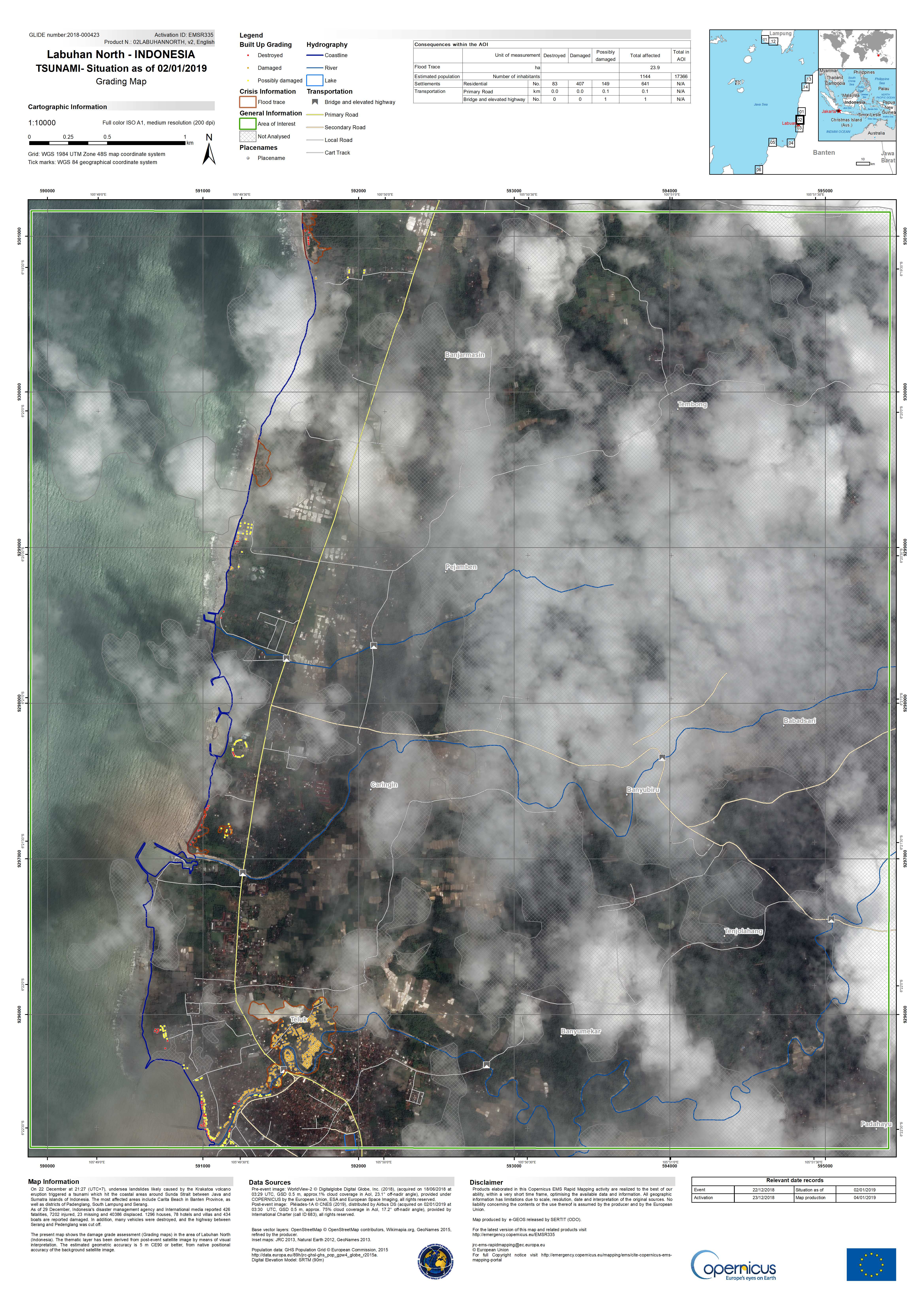
Damage grade assessment of Labuhan North, Indonesia
Direitos autorais: WorldView-2 © DigitalGlobe Inc.
Pleiades © CNES (2019) - Distribution: Airbus Defence and Space, all rights reserved
Map produced by Copernicus EMS
Information about the Product
Adquirida: WorldView-2: 18/06/2018
Pleiades: 02/01/2019
Fonte: WorldView-2 / Pleiades
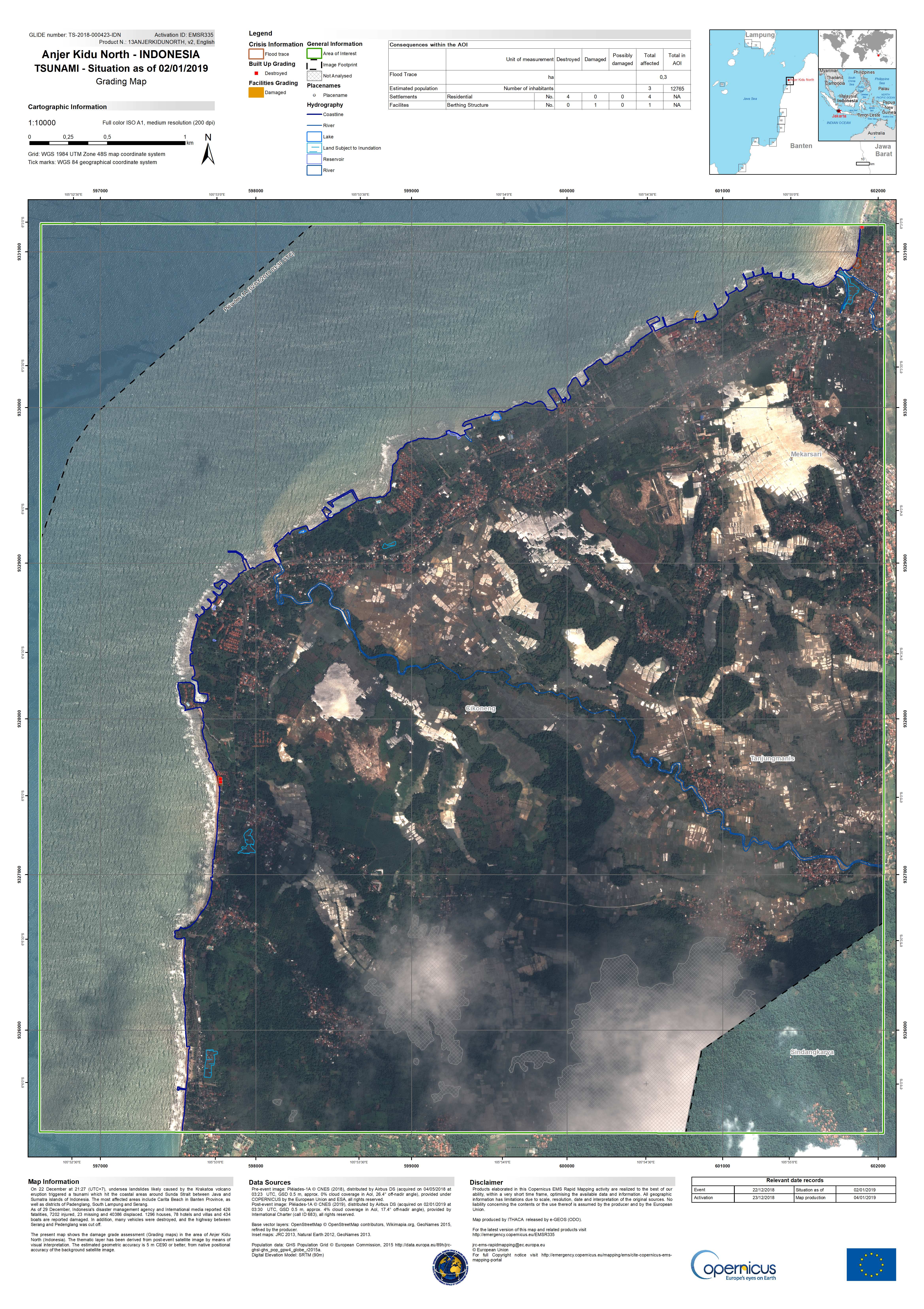
Damage grade assessment of Anjer Kidu North, Indonesia
Direitos autorais: Pleiades © CNES (2019) - Distribution: Airbus Defence and Space, all rights reserved
Map produced by Copernicus EMS
Information about the Product
Adquirida: Pre-disaster: 04/05/2018
Post-disaster: 02/01/2019
Fonte: Pleiades
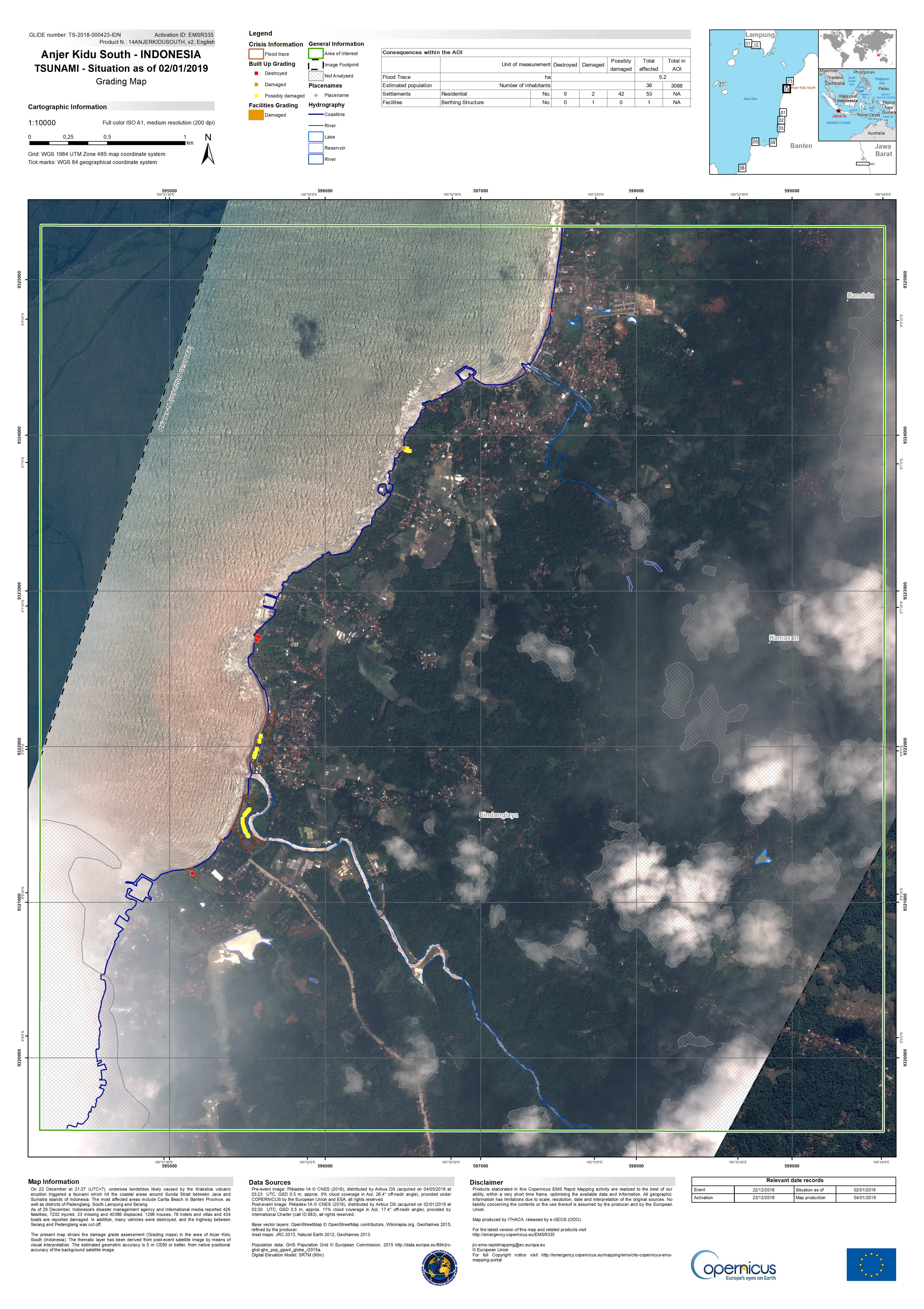
Damage grade assessment of Anjer Kidu South, Indonesia
Direitos autorais: Pleiades © CNES (2019) - Distribution: Airbus Defence and Space, all rights reserved
Map produced by Copernicus EMS
Information about the Product
Adquirida: Pre-disaster: 04/05/2018
Post-disaster: 02/01/2019
Fonte: Pleiades
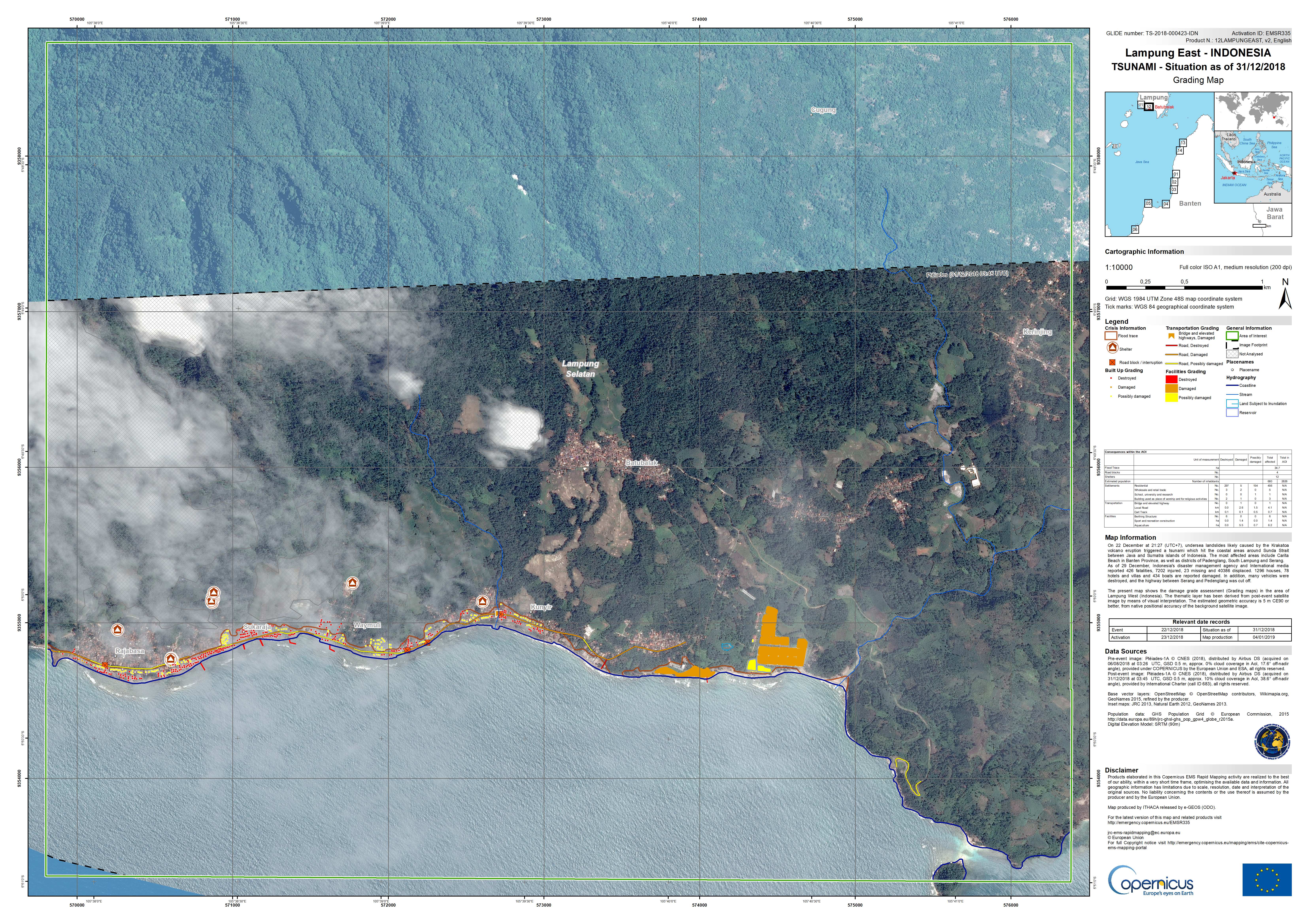
Damage grade assessment of Lampung East, Indonesia
Direitos autorais: Pleiades © CNES (2018) - Distribution: Airbus Defence and Space, all rights reserved
Map produced by Copernicus EMS
Information about the Product
Adquirida: Pre-disaster: 06/08/2018
Post-disaster: 31/12/2018
Fonte: Pleiades
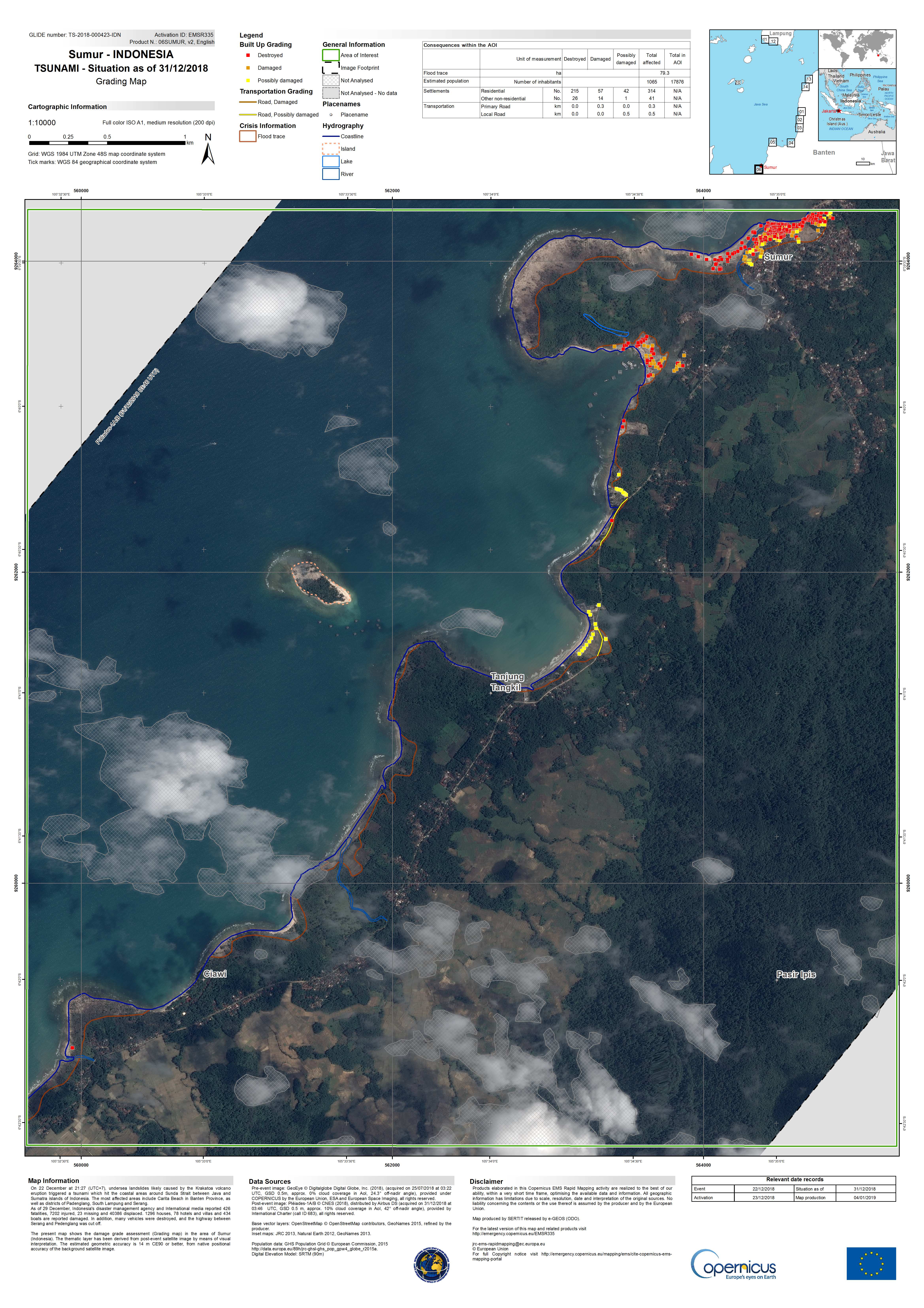
Damage grade assessment of Sumur, Indonesia
Direitos autorais: GeoEye © DigitalGlobe Inc.
Pleiades © CNES (2018) - Distribution: Airbus Defence and Space, all rights reserved
Map produced by Copernicus EMS
Information about the Product
Adquirida: GeoEye: 25/07/2018
Pleiades: 31/12/2018
Fonte: GeoEye / Pleiades
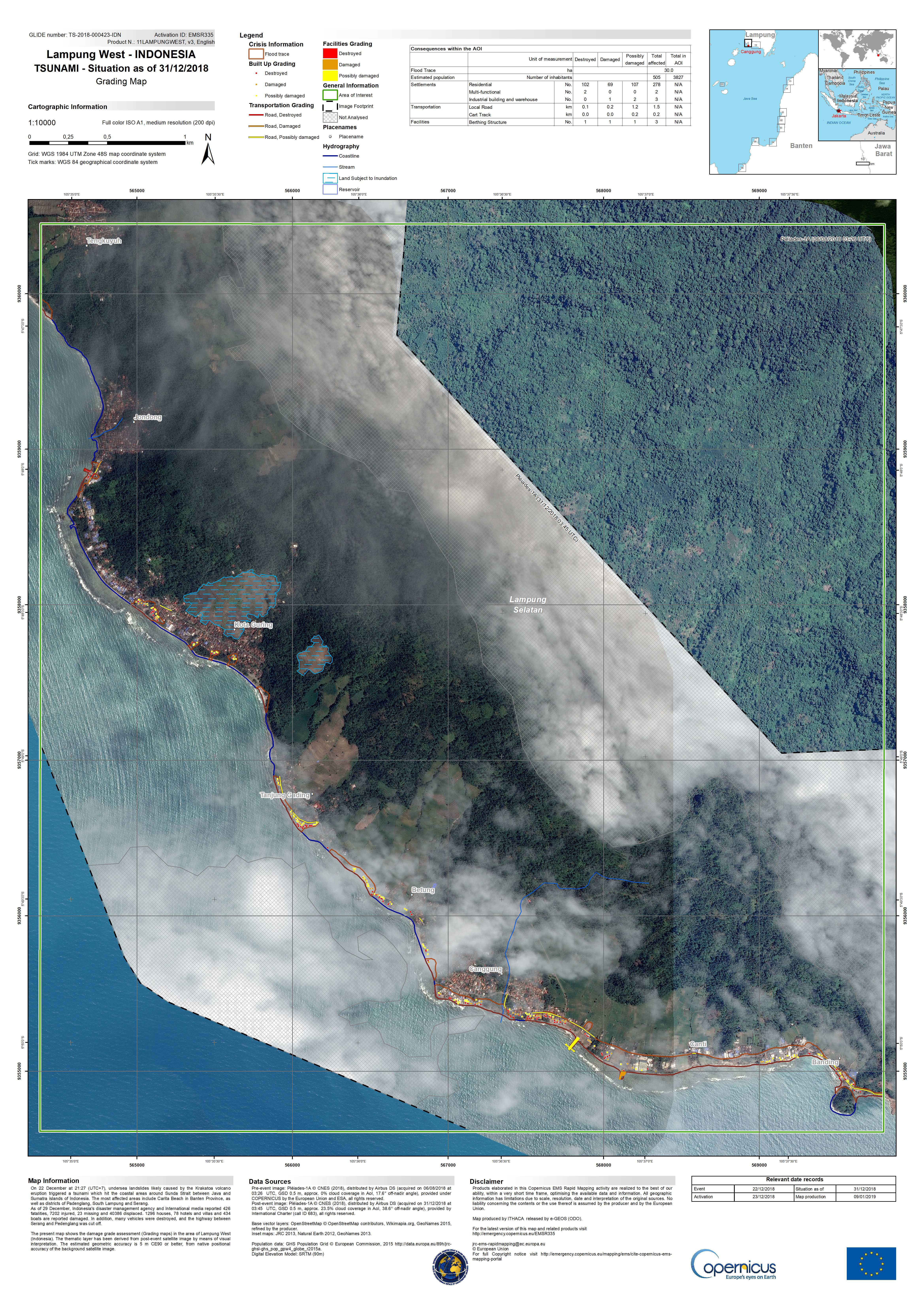
Damage grade assessment of Lampung West, Indonesia
Direitos autorais: Pleiades © CNES (2018) - Distribution: Airbus Defence and Space, all rights reserved
Map produced by Copernicus EMS
Information about the Product
Adquirida: Pre-disaster: 06/08/2018
Post-disaster: 31/12/2018
Fonte: Pleiades
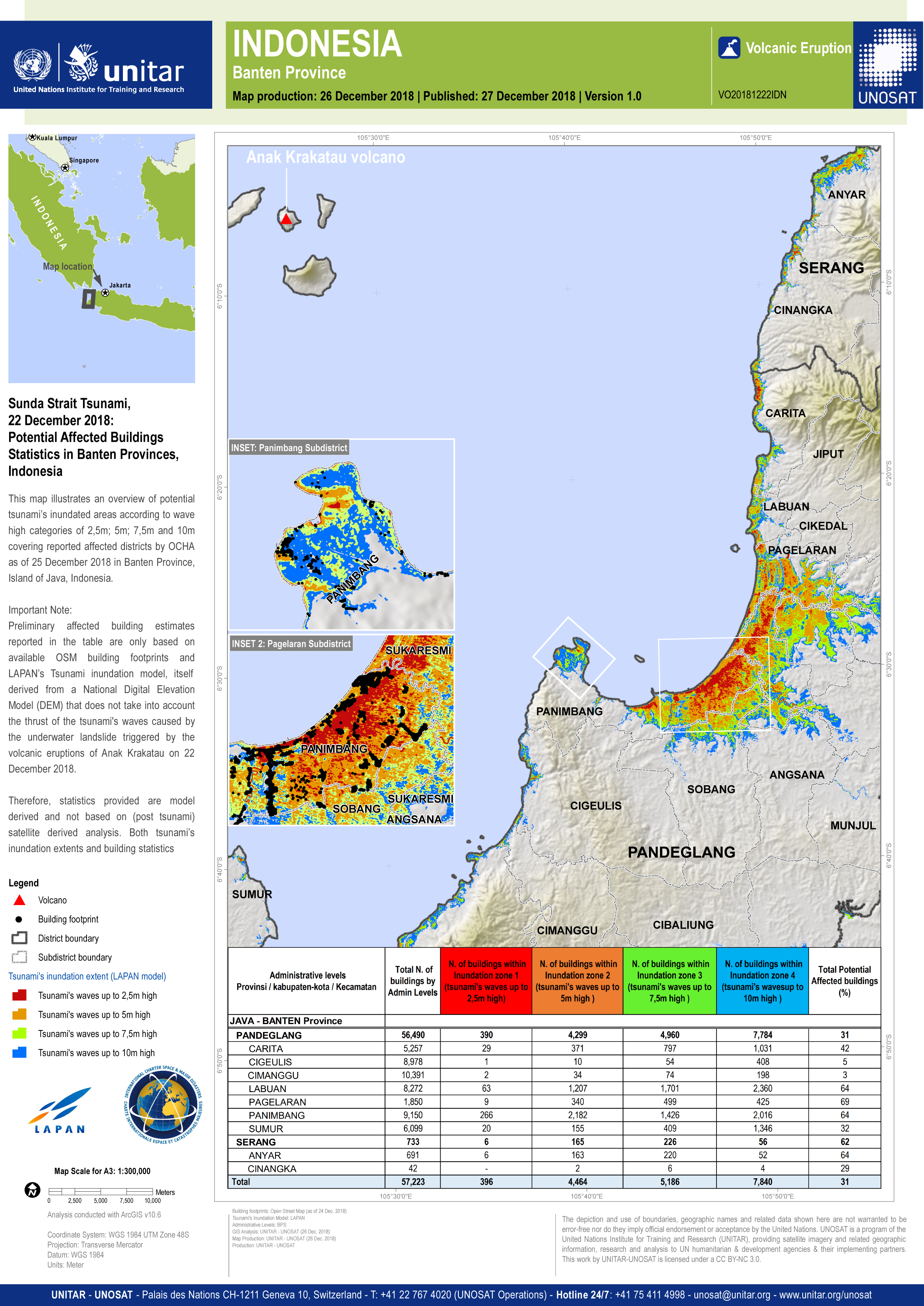
Potentially affected buildings in Banten Province, Indonesia
Direitos autorais: Map produced by UNITAR/UNOSAT
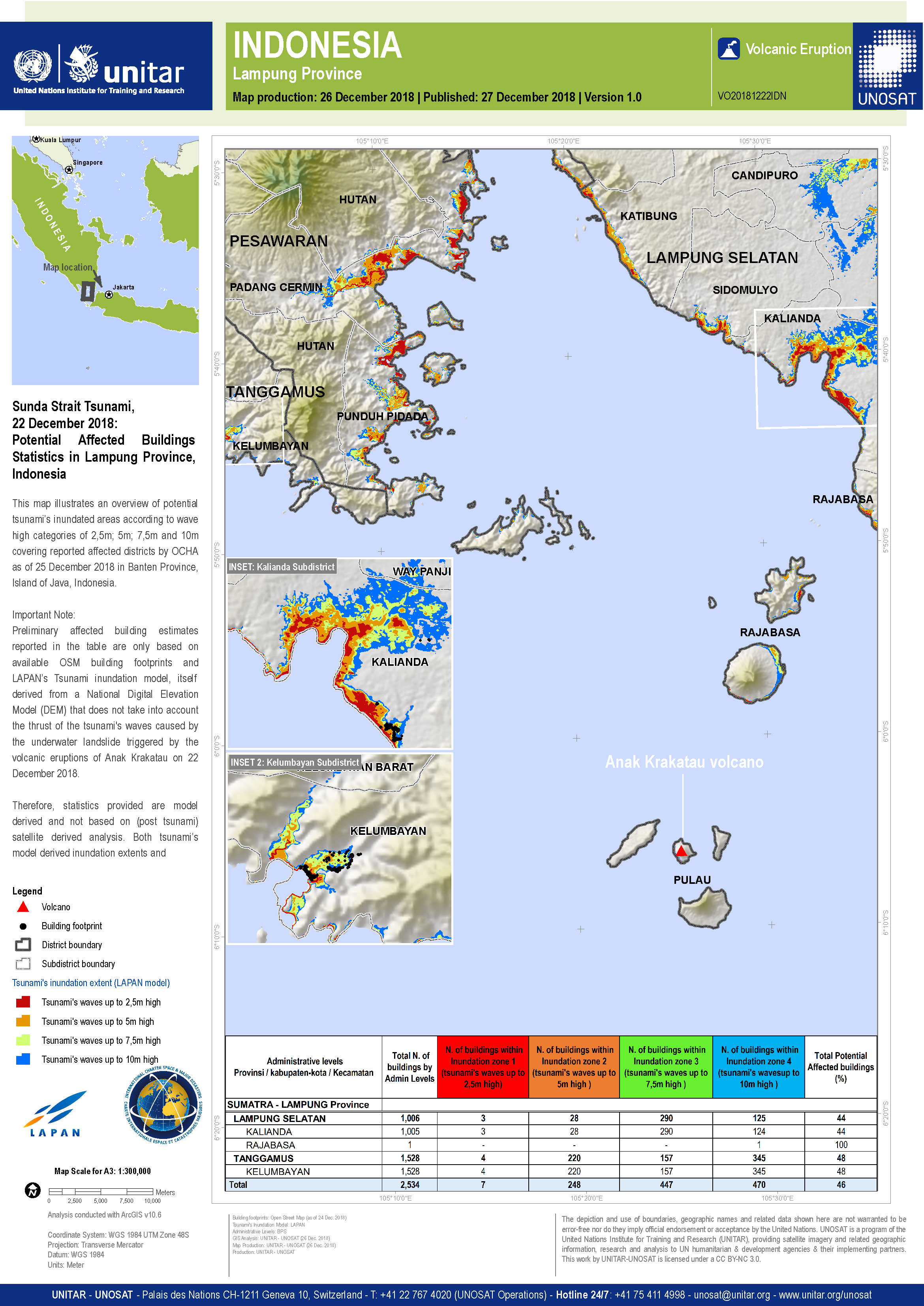
Potentially affected buildings in Lampung Province, Indonesia
Direitos autorais: Map produced by UNITAR/UNOSAT
 Voltar ao arquivo completo da Ativação

