 English
 Spanish
 French
 Chinese
 Russian
 Portuguese
 Latest Activation
Charter activations
Cyclone Gita in Tonga
Cyclone Gita, a Category 4 storm, hit Tonga on 12 February after causing widespread damage in the neighbouring island of Samoa. The eye of the storm passed over Tongatapu island, the most populous island group in Tonga, causing one fatalitly and injuring 33.
The National Emergency Management Office (NEMO) reported that 79% of the population had been affected, and confirmed Gita as the strongest storm to his the islands on record. Over 100 evacuation centres were prepared to house over 4500 evacuees as the Tongan government declared a state of emergency.
Gita caused extensive flooding in low lying, coastal and river areas around Savai'I and Upolu and further widesread flooding in the Vaisigano catchment area with thousands of properties being damaged.
The storm affected Tonga's power supply, with authorities confirming that Tongatapu was without power after winds exceeding 190 mph damaged infrastructure, leaving hospitals only remaining operational through generators.
By the 15 February the storm moved south-southwest away from Tonga heading towards New Caledonia.
| Tipo de evento: | Ocean Storm - Cyclone |
| Local do evento: | Tonga |
| Data da Ativação da Carta: | 2018-02-12 |
| Tempo de Ativação da Carta: | 09:28 |
| Zona de Tempo da Ativação da Carta: | UTC+01:00 |
| Requisitante da Carta: | UNITAR-UNOSAT on behalf of United Nations Office for the Coordination of Humanitarian Affairs (OCHA) | Regional Office for Asia and the Pacific (ROAP) |
| ID da Ativação: | 566 |
| Gerenciamento de projeto: | UNITAR/UNOSAT |
Products
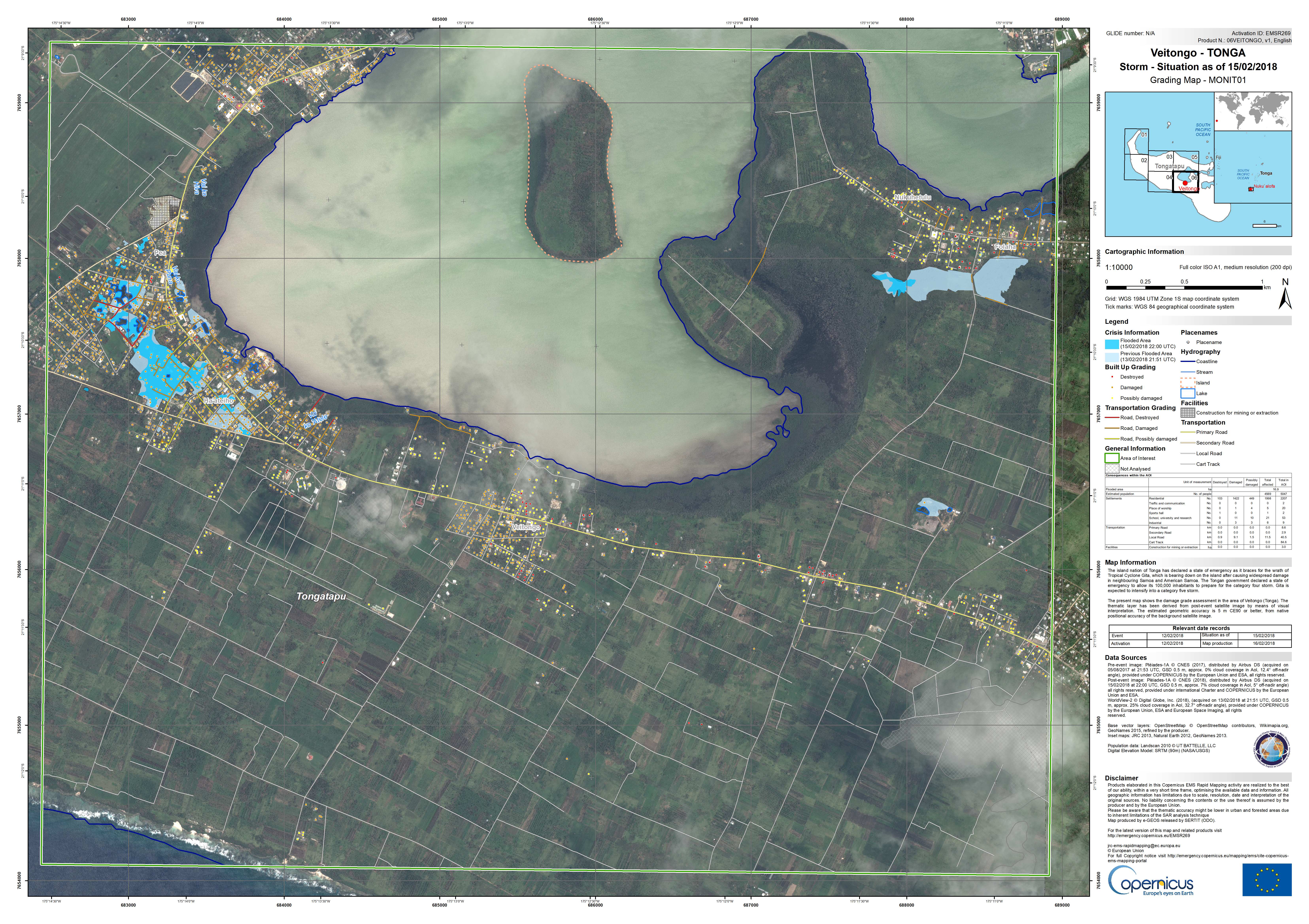
Grading map of Veitongo on Tongatapu Island
See more from Copernicus EMS
Direitos autorais: Pleiades © CNES (2018) - Distribution: Airbus Defence and Space, all rights reserved
WorldView-2 © DigitalGlobe Inc.
Map produced by e-GEOS
Information about the Product
Adquirida: Pleiades: 05/08/2017 and 15/02/2018
WorldView-2: 13/02/2018
Fonte: Pleiades / WorldView-2
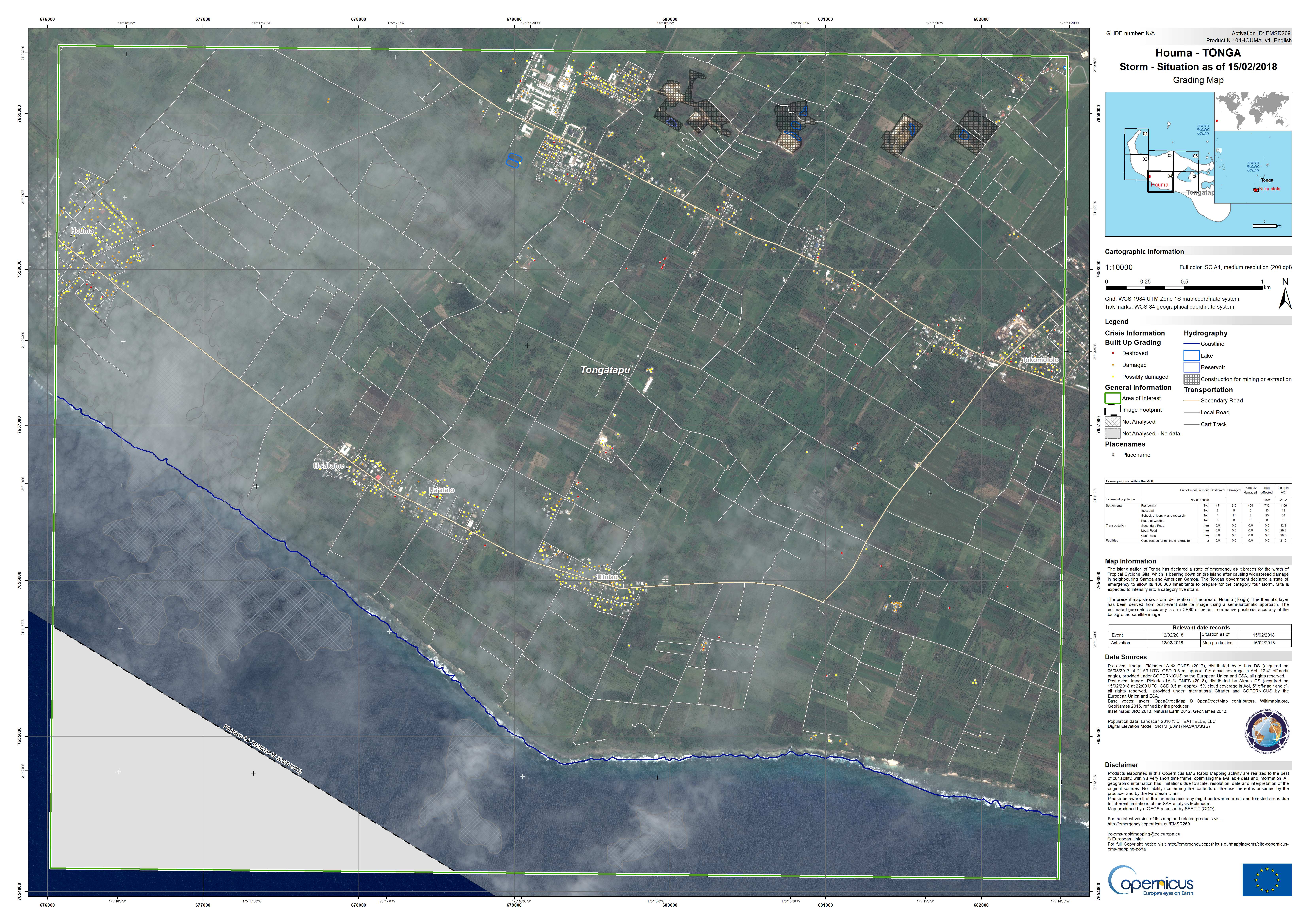
Grading map of Houma on Tongatapu Island
See more from Copernicus EMS
Direitos autorais: Pleiades © CNES (2018) - Distribution: Airbus Defence and Space, all rights reserved
Map produced by e-GEOS
Information about the Product
Adquirida: Pre-disaster: 05/08/2017
Post-disaster: 15/02/2018
Fonte: Pleiades
GITA-18: Comprehensive Satellite Detected Building Damage Assessment Overview As Of 28 February 2018
Download the full report
Direitos autorais: Pleiades © CNES (2018) - Distribution: Airbus Defence and Space, all rights reserved
WorldView-2 © DigitalGlobe Inc.
WorldView-3 © DigitalGlobe Inc.
Map produced by UNITAR/UNOSAT
Information about the Product
Adquirida: Pleiades: 14/02/2018, 15/02/2018, 16/02/2018 and 21/02/2018
WorldView-3: 12/01/2018
WorldView-2: 13/02/2018
Fonte: Pleiades / WorldView-2 / WorldView-3
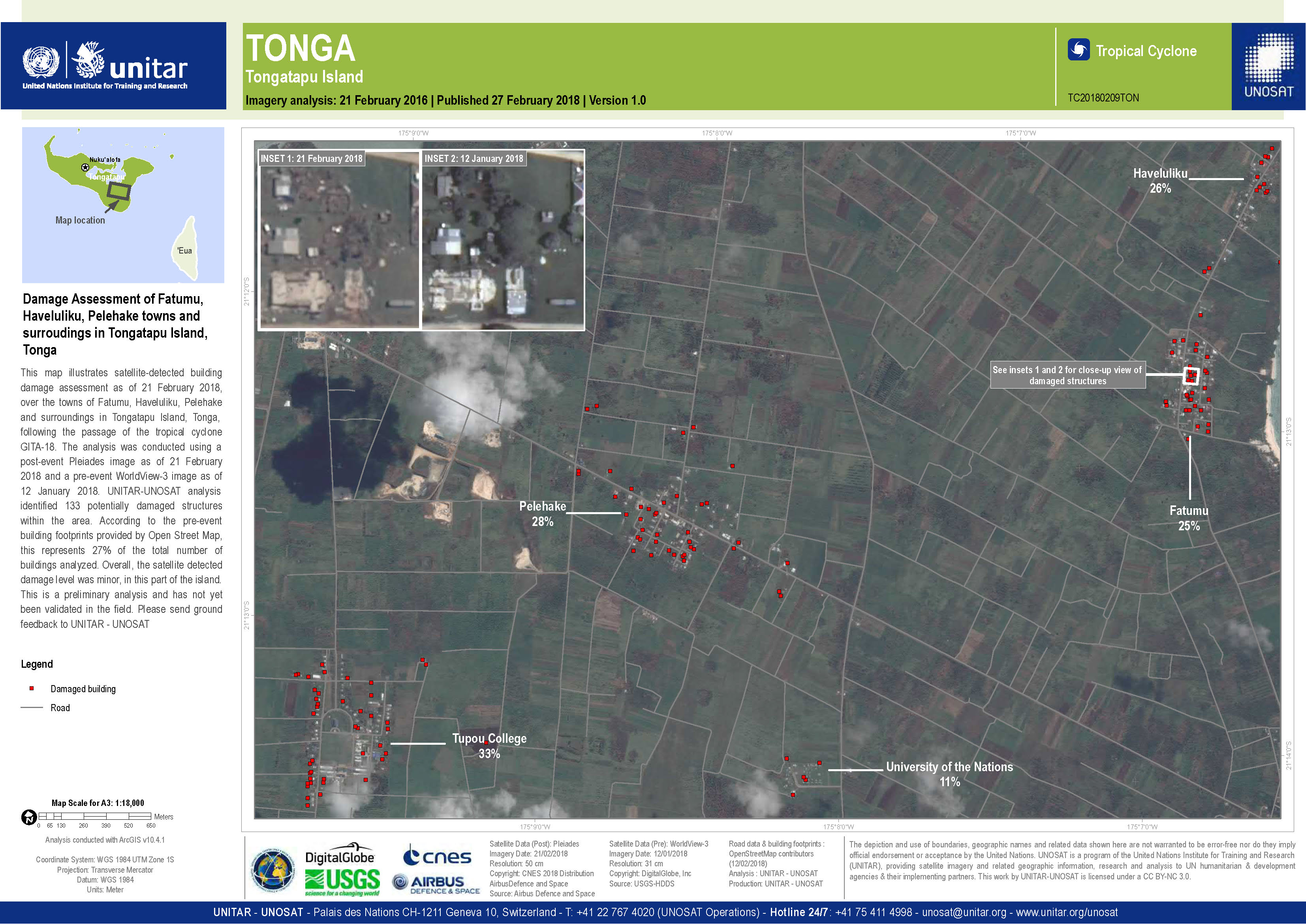
Damage assessment of Fatumu, Haveluliku, Pelehake, in Tongatapu Island
Direitos autorais: Pleiades © CNES (2018) - Distribution: Airbus Defence and Space, all rights reserved
WorldView-3 © DigitalGlobe Inc.
Map produced by UNITAR/UNOSAT
Information about the Product
Adquirida: Pleiades: 21/02/2018
WorldView-3: 12/01/2018
Fonte: Pleiades / WorldView-3
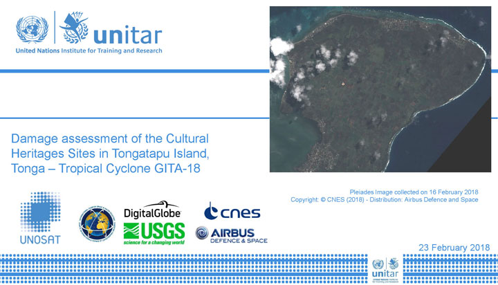
Damage assessment of Cultural Heritage Sites in Tongatapu Island
Download the full report
Direitos autorais: Pleiades © CNES (2018) - Distribution: Airbus Defence and Space, all rights reserved
WorldView-3 © DigitalGlobe Inc.
Map produced by UNITAR/UNOSAT
Information about the Product
Adquirida: Pleiades: 15/02/2018 and 16/02/2018
WorldView-3: 12/01/2018
Fonte: Pleiades / WorldView-3
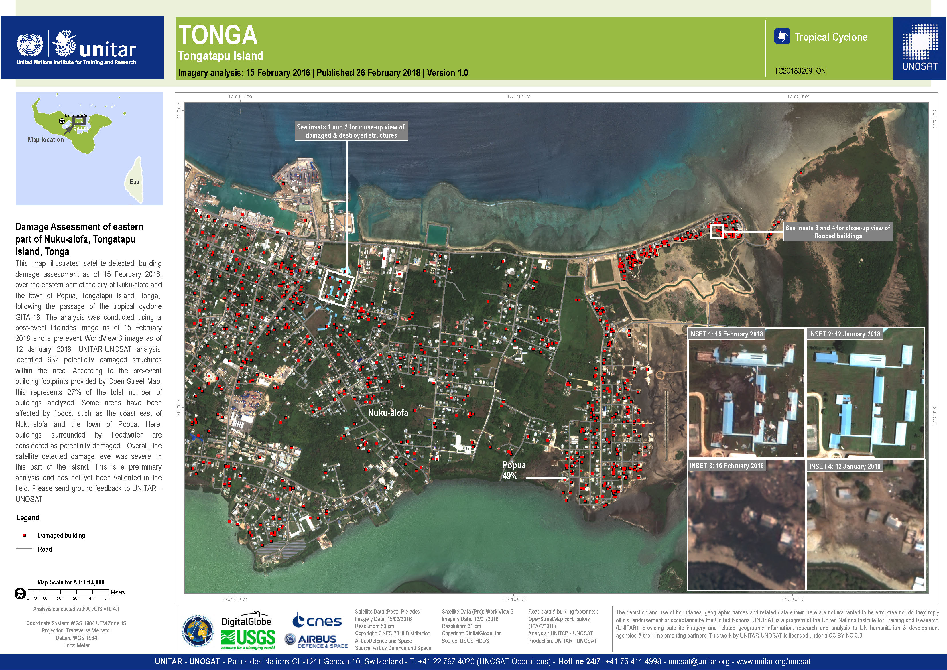
Damage assessment of eastern Nuku-alofa, Tongatapu Island
Direitos autorais: Pleiades © CNES (2018) - Distribution: Airbus Defence and Space, all rights reserved
WorldView-3 © DigitalGlobe Inc.
Map produced by UNITAR/UNOSAT
Information about the Product
Adquirida: Pleiades: 15/02/2018
WorldView-3: 12/01/2018
Fonte: Pleiades / WorldView-3
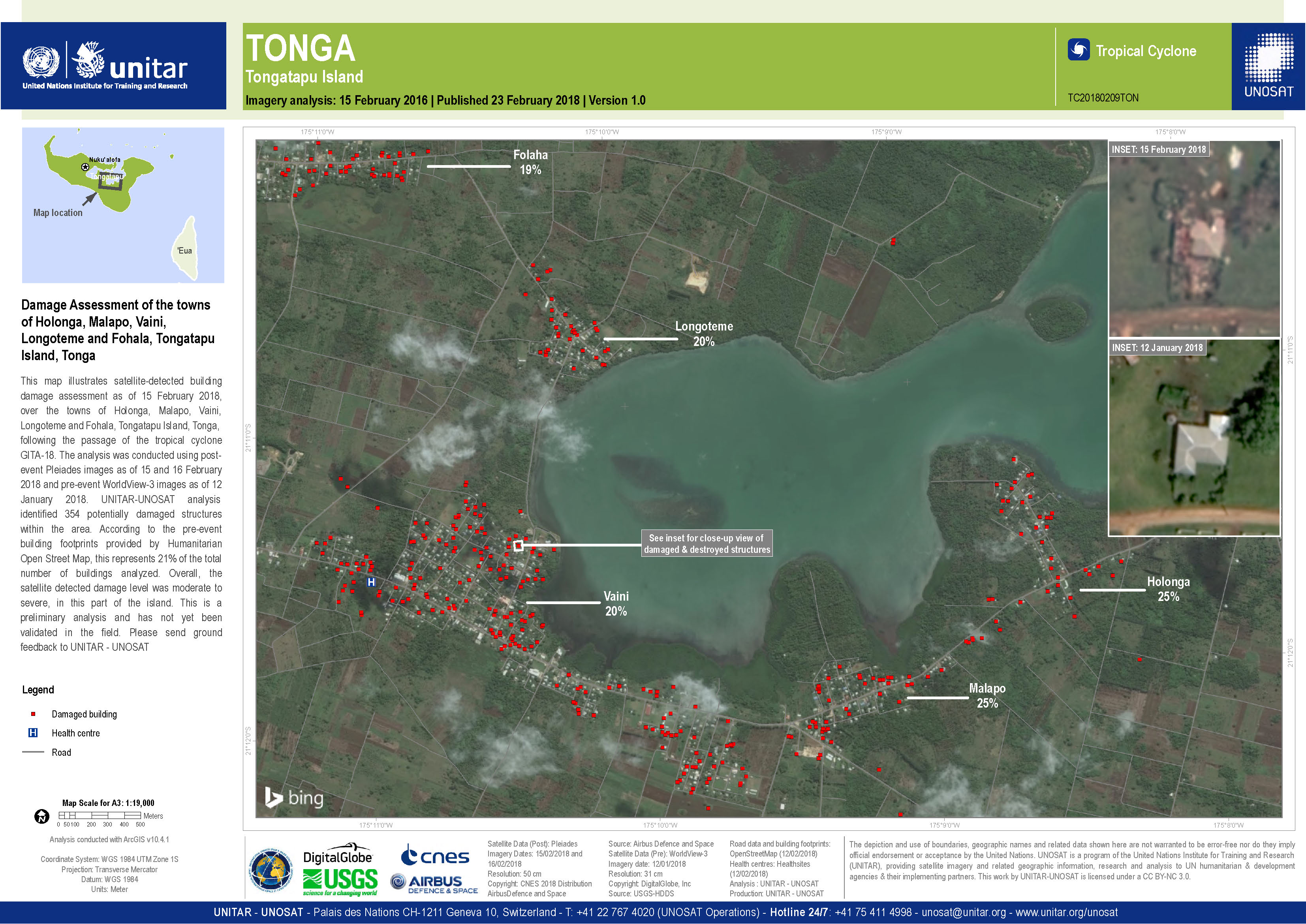
Damage assessment of the towns of Holonga, Malapo, Vaini, Longoteme and Fohala, Tongatapu Island
Direitos autorais: WorldView-3 © DigitalGlobe Inc.
Pleiades © CNES (2018) - Distribution: Airbus Defence and Space, all rights reserved
Map produced by UNITAR/UNOSAT
Information about the Product
Adquirida: WorldView-3: 12/01/2018
Pleiades: 15/02/2018
Fonte: WorldView-3 / Pleiades
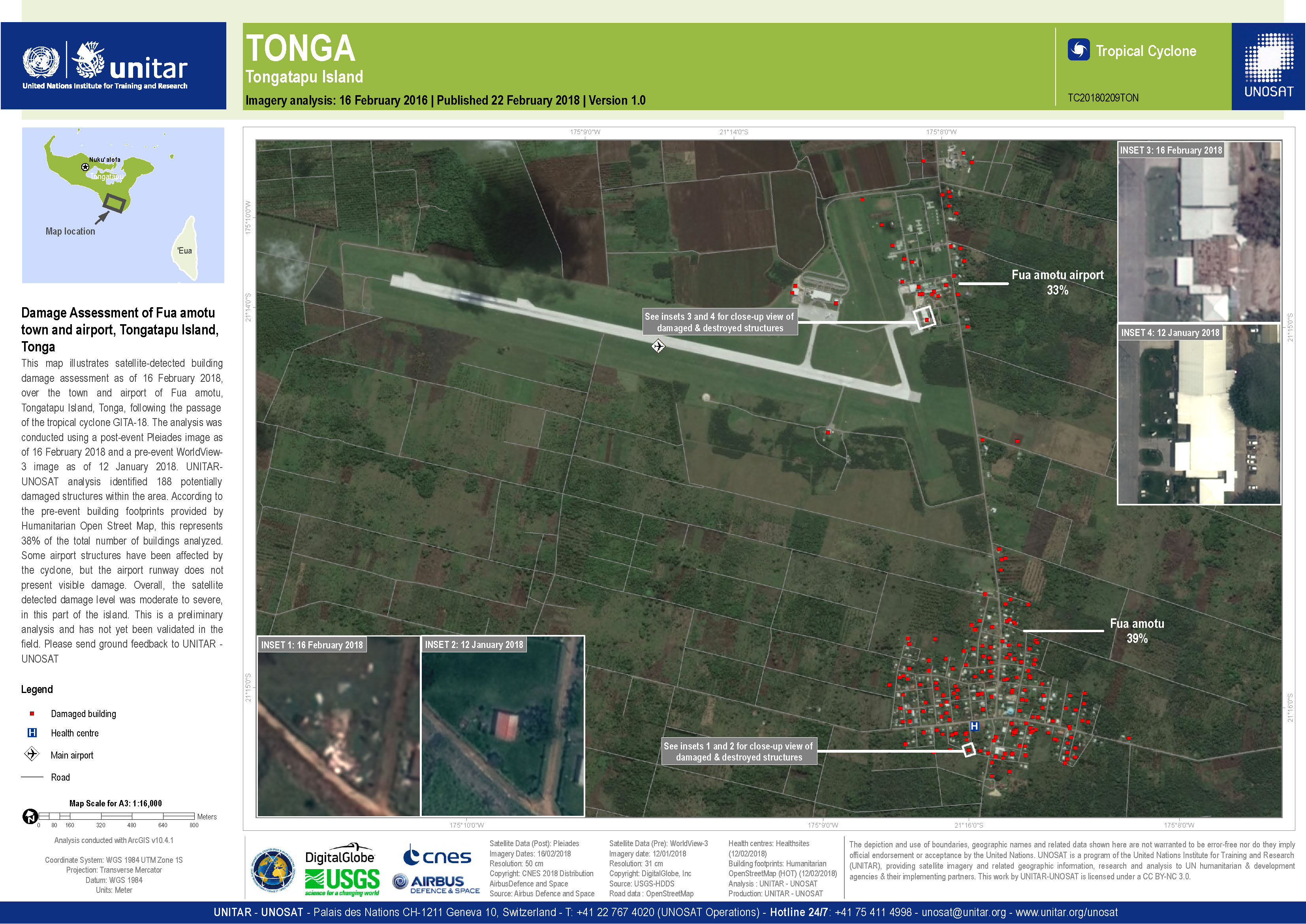
Damage assessment of Fua amotu town and airport, Tongatapu Island
Direitos autorais: WorldView-3 © DigitalGlobe Inc.
Pleiades © CNES (2018) - Distribution: Airbus Defence and Space, all rights reserved
Map produced by UNITAR/UNOSAT
Information about the Product
Adquirida: WorldView-3: 12/01/2018
Pleiades: 16/02/2018
Fonte: WorldView-3 / Pleiades
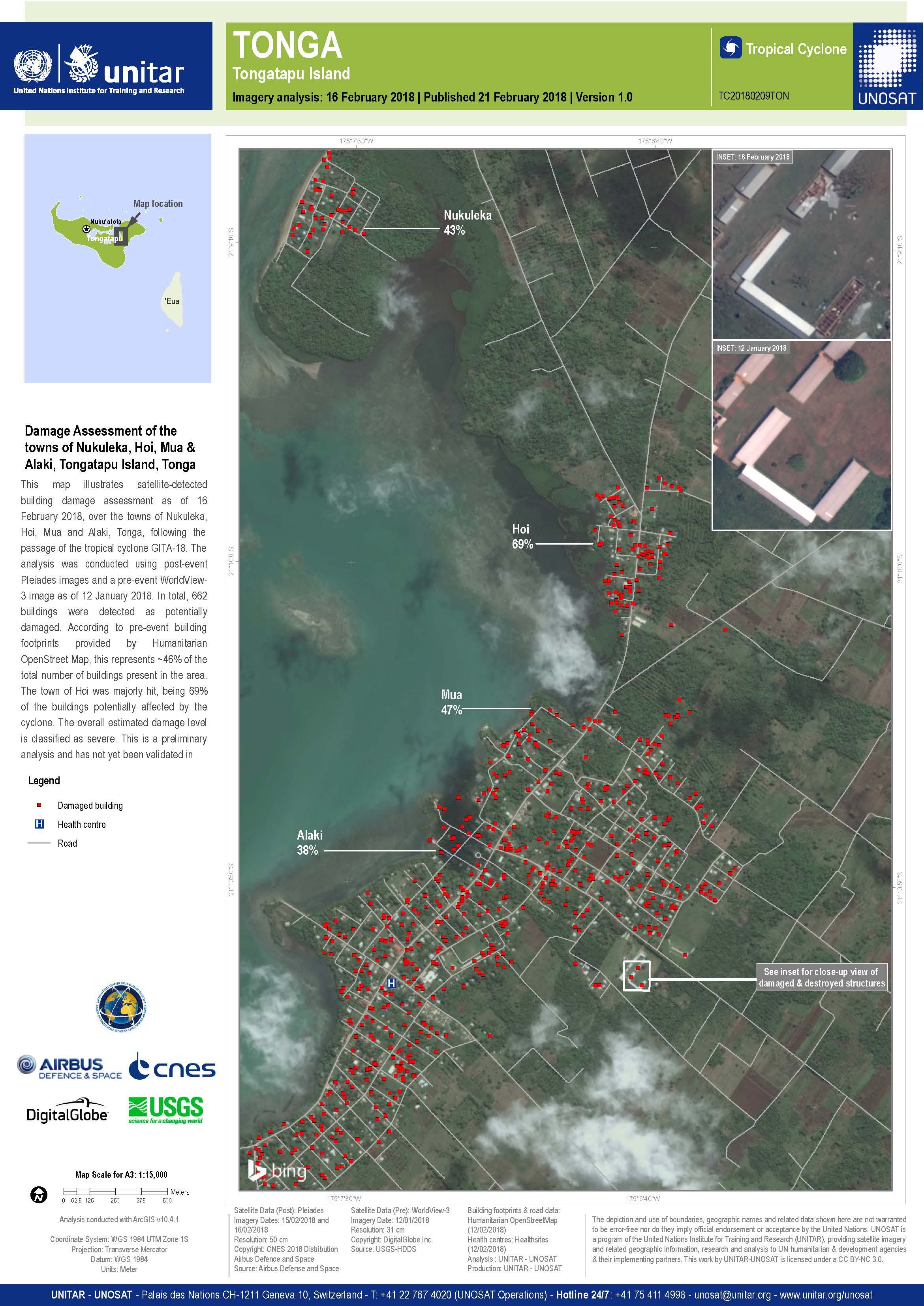
Damage assessment of the towns of Nukuleka, Hoi, Mua & Alaki, on Tongatapu Island
Direitos autorais: WorldView-3 © DigitalGlobe Inc.
Pleiades © CNES (2018) - Distribution: Airbus Defence and Space, all rights reserved
Map produced by UNITAR/UNOSAT
Information about the Product
Adquirida: WorldView-3: 12/01/2018
Pleiades: 15/02/2018 and 16/02/2018
Fonte: WorldView-3 / Pleiades
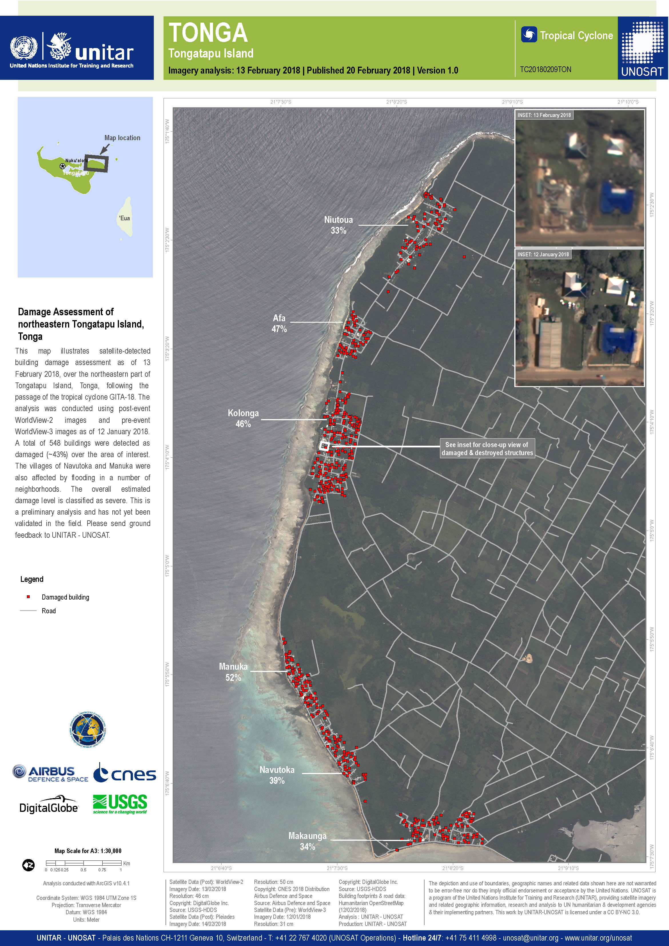
Damage assessment of Tongatapu Island
Direitos autorais: WorldView-2 and -3 © DigitalGlobe Inc.
Pleiades © CNES (2018) - Distribution: Airbus Defence and Space, all rights reserved
Map produced by UNITAR/UNOSAT
Information about the Product
Adquirida: WorldView-2: 13/02/2018
WorldView-3: 12/01/2018
Pleiades: 14/02/2018
Fonte: WorldView-2 / WorldView-3 / Pleiades
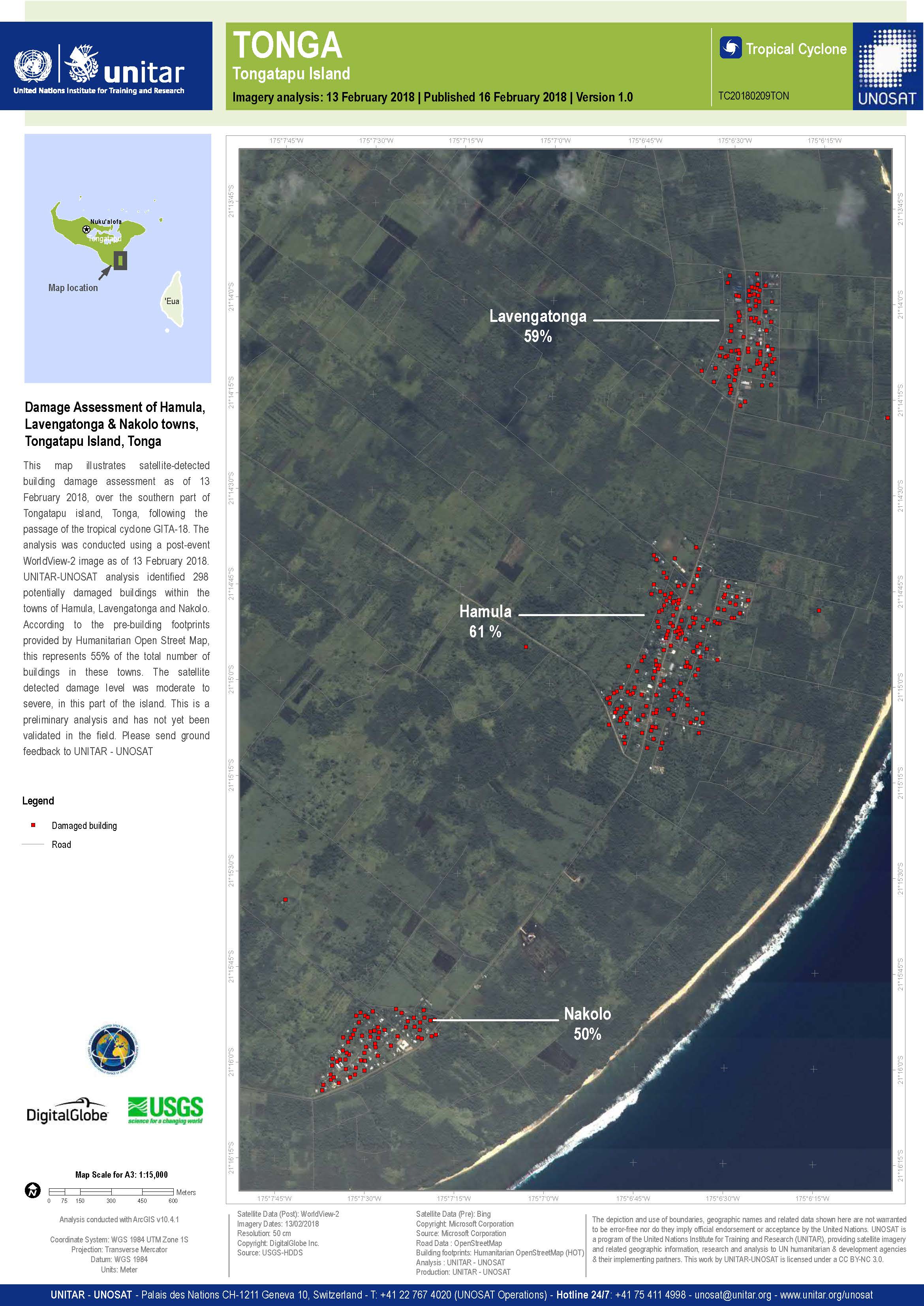
Damage assessment of Hamula, Lavengatonga and Nakolo towns on Tongatapu island
Direitos autorais: WorldView-2 © DigitalGlobe Inc.
Map produced by UNITAR/UNOSAT
Information about the Product
Adquirida: 13/02/2018
Fonte: WorldView-2
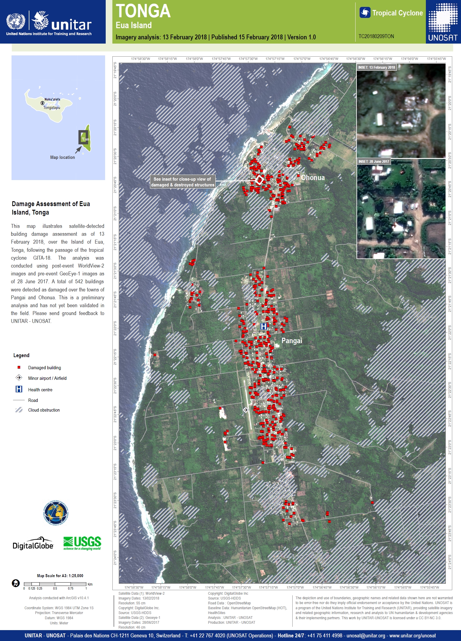
Damage assessment of Eua Island
Direitos autorais: GeoEye-1 and WorldView-2 © DigitalGlobe Inc.
Map produced by UNITAR/UNOSAT
Information about the Product
Adquirida: GeoEye-1: 28/06/2017
WorldView-2: 13/02/2018
Fonte: GeoEye-1 / WorldView-2
 Voltar ao arquivo completo da Ativação

