 English
 Spanish
 French
 Chinese
 Russian
 Portuguese
 Última Activación
Charter activations
Cyclone Gita in Tonga
Cyclone Gita, a Category 4 storm, hit Tonga on 12 February after causing widespread damage in the neighbouring island of Samoa. The eye of the storm passed over Tongatapu island, the most populous island group in Tonga, causing one fatalitly and injuring 33.
The National Emergency Management Office (NEMO) reported that 79% of the population had been affected, and confirmed Gita as the strongest storm to his the islands on record. Over 100 evacuation centres were prepared to house over 4500 evacuees as the Tongan government declared a state of emergency.
Gita caused extensive flooding in low lying, coastal and river areas around Savai'I and Upolu and further widesread flooding in the Vaisigano catchment area with thousands of properties being damaged.
The storm affected Tonga's power supply, with authorities confirming that Tongatapu was without power after winds exceeding 190 mph damaged infrastructure, leaving hospitals only remaining operational through generators.
By the 15 February the storm moved south-southwest away from Tonga heading towards New Caledonia.
| Type of Event: | Ocean Storm - Cyclone |
| Location of Event: | Tonga |
| Date of Charter Activation: | 2018-02-12 |
| Time of Charter Activation: | 09:28 |
| Time zone of Charter Activation: | UTC+01:00 |
| Charter Requestor: | UNITAR-UNOSAT on behalf of United Nations Office for the Coordination of Humanitarian Affairs (OCHA) | Regional Office for Asia and the Pacific (ROAP) |
| Activation ID: | 566 |
| Project Management: | UNITAR/UNOSAT |
Products
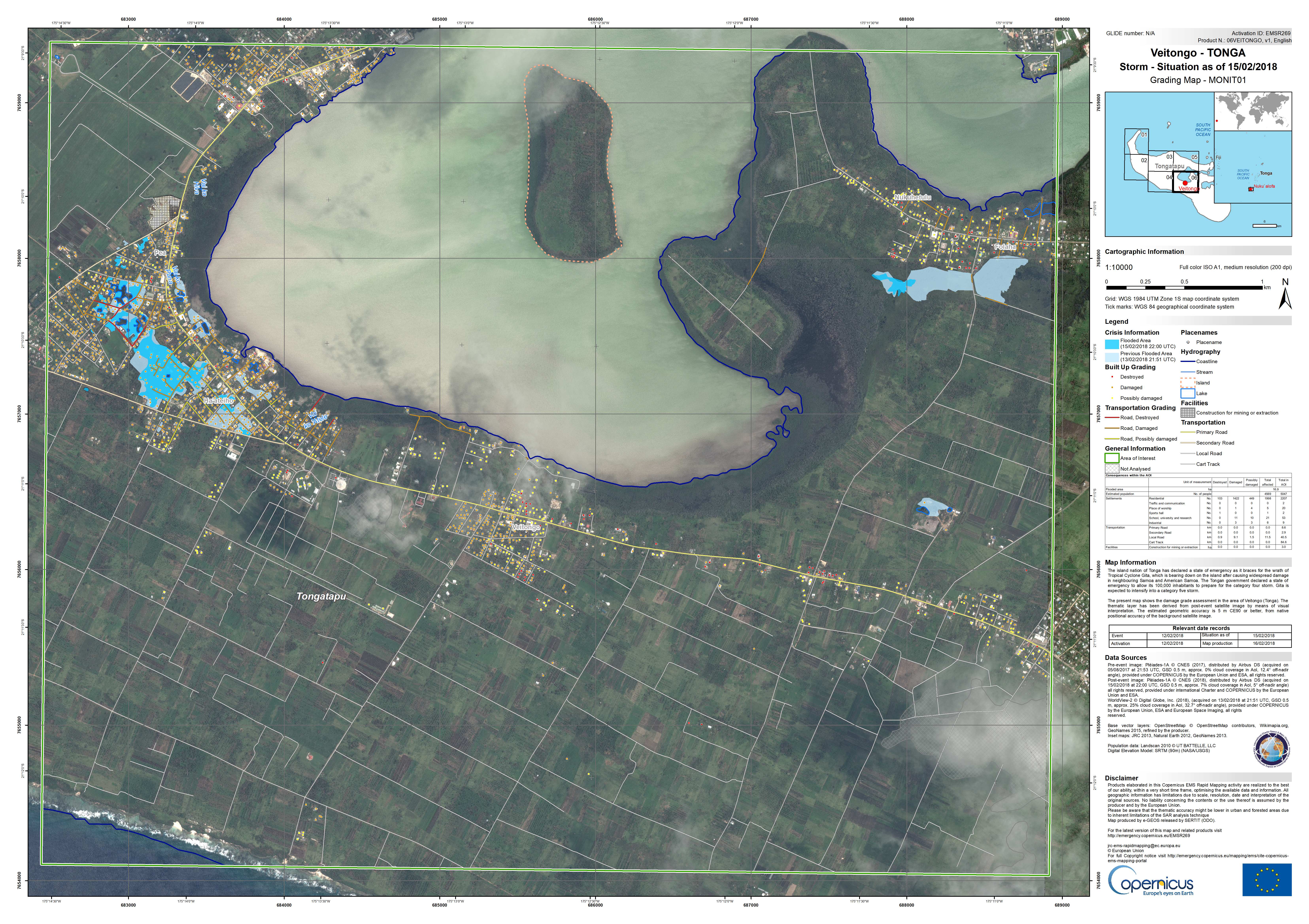
Mapa de calificación de Veitongo en la isla de Tongatapu
Ver más de Copernicus EMS
Copyright: Pleiades © CNES (2018) - Distribución: Airbus Defence and Space, reservados todos los derechos
WorldView-2 © DigitalGlobe Inc.
Mapa producido por e-GEOS
Information about the Product
Acquired: Pleiades: 05/08/2017 y 15/02/2018
WorldView-2: 13/02/2018
Source: Pleiades / WorldView-2
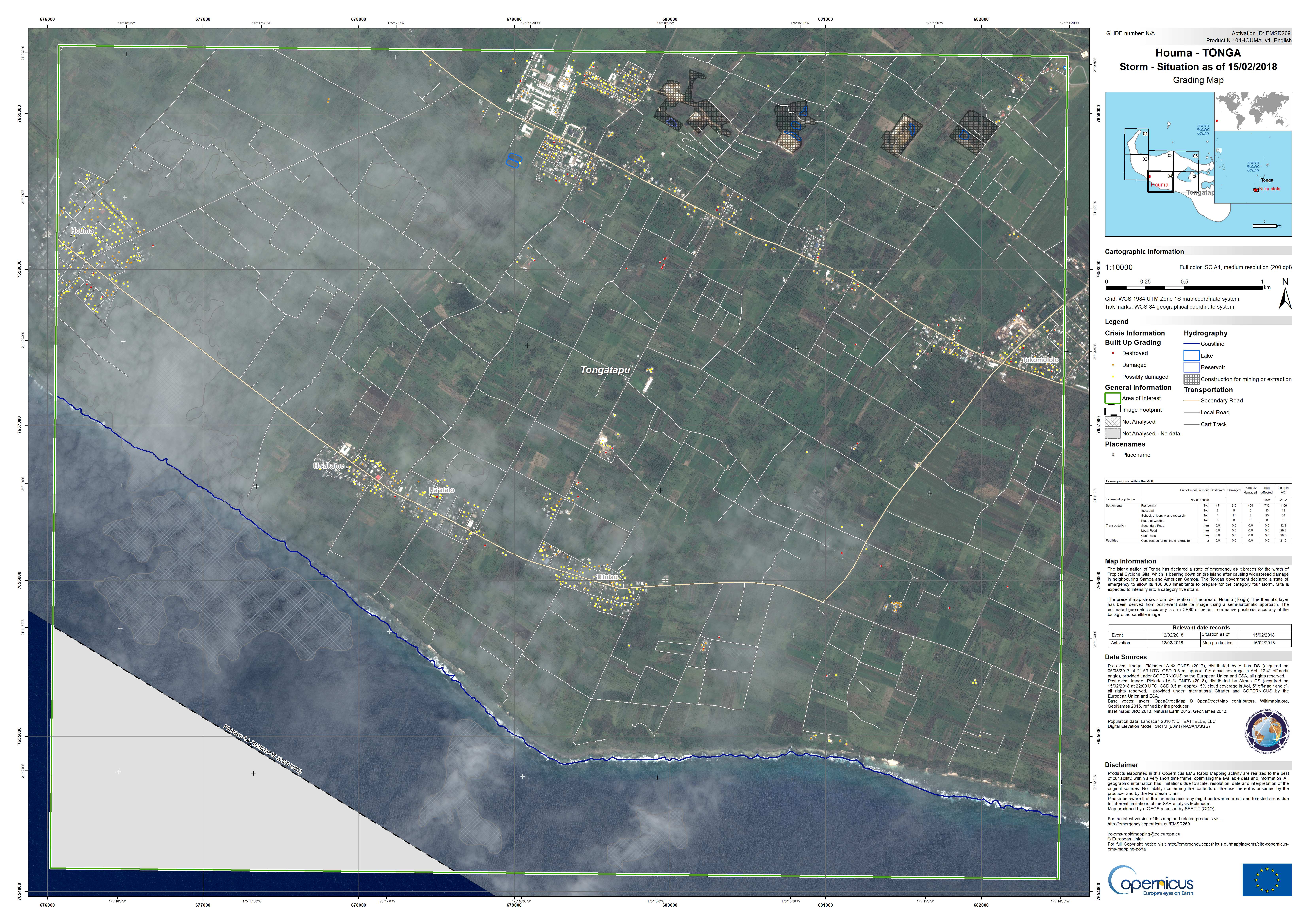
Mapa de calificación de Houma en la isla Tongatapu
Ver más de Copernicus EMS
Copyright: Pleiades © CNES (2018) - Distribución: Airbus Defence and Space, reservados todos los derechos
Mapa producido por e-GEOS
Information about the Product
Acquired: Antes del desastre: 05/08/2017
Después de los desastres: 15/02/2018
Source: Pleiades
Gita-18: Visión general de la evaluación integral de daños a edificios detectados por satélite a partir del 28 de febrero de 2018
Descargue el informe completo
Copyright: Pleiades © CNES (2018) - Distribución: Airbus Defence and Space, reservados todos los derechos
WorldView-2 © DigitalGlobe Inc.
WorldView-3 © DigitalGlobe Inc.
Mapa producido porUNITAR/UNOSAT
Information about the Product
Acquired: Pleiades: 14/02/2018, 15/02/2018, 16/02/2018 y 21/02/2018
WorldView-3: 12/01/2018
WorldView-2: 13/02/2018
Source: Pleiades / WorldView-2 / WorldView-3
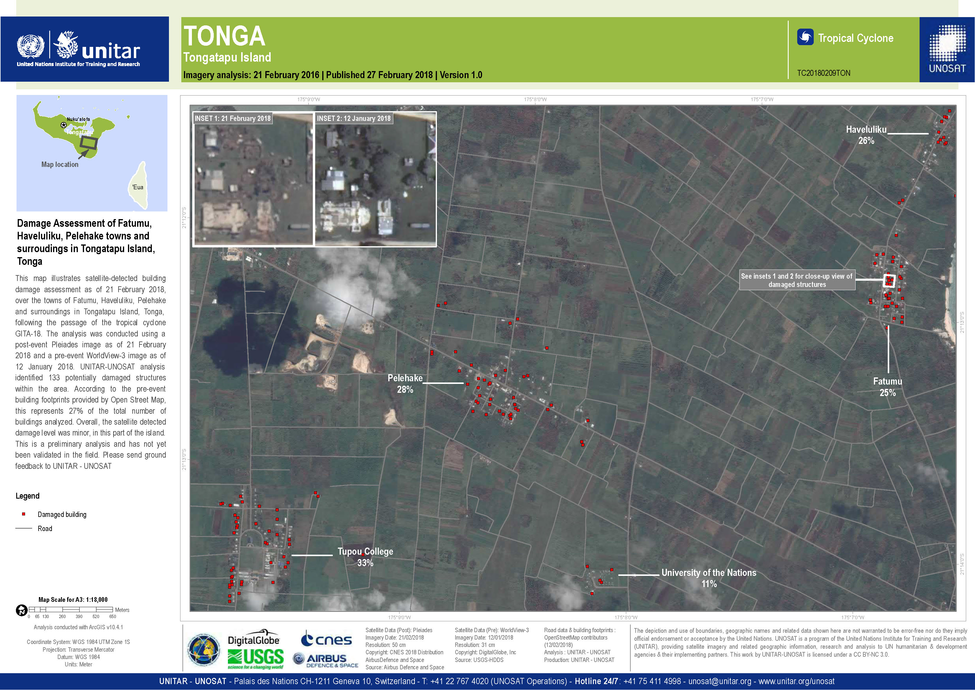
Evaluación de daños de Fatumu, Haveluliku, Pelehake, en la isla de Tongatapu
Copyright: Pleiades © CNES (2018) - Distribución: Airbus Defence and Space, reservados todos los derechos
WorldView-3 © DigitalGlobe Inc.
Mapa producido por UNITAR/UNOSAT
Information about the Product
Acquired: Pleiades: 21/02/2018
WorldView-3: 12/01/2018
Source: Pleiades / WorldView-3
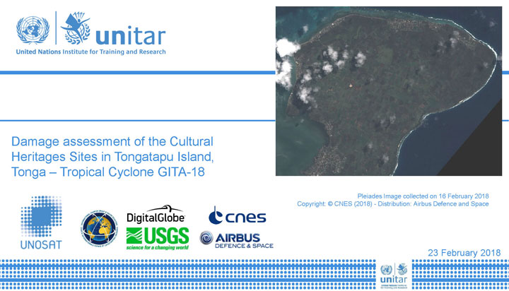
Evaluación de daños de sitios del patrimonio cultural en la isla de Tongatapu
Descargue el informe completo
Copyright: Pleiades © CNES (2018) - Distribución: Airbus Defence and Space, reservados todos los derechos
WorldView-3 © DigitalGlobe Inc.
Mapa producido por UNITAR/UNOSAT
Information about the Product
Acquired: Pleiades: 15/02/2018 y 16/02/2018
WorldView-3: 12/01/2018
Source: Pleiades / WorldView-3
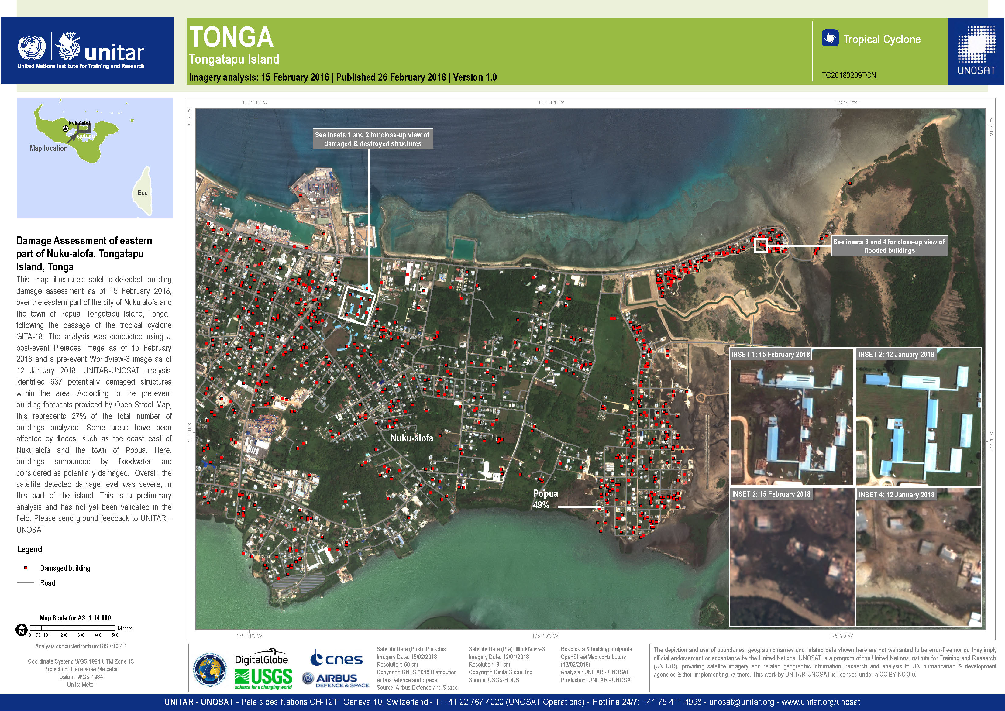
Evaluación de daños del este de Nuku-alofa, isla de Tongatapu
Copyright: Pleiades © CNES (2018) - Distribución: Airbus Defence and Space, reservados todos los derechos
WorldView-3 © DigitalGlobe Inc.
Mapa producido por UNITAR/UNOSAT
Information about the Product
Acquired: Pleiades: 15/02/2018
WorldView-3: 12/01/2018
Source: Pleiades / WorldView-3
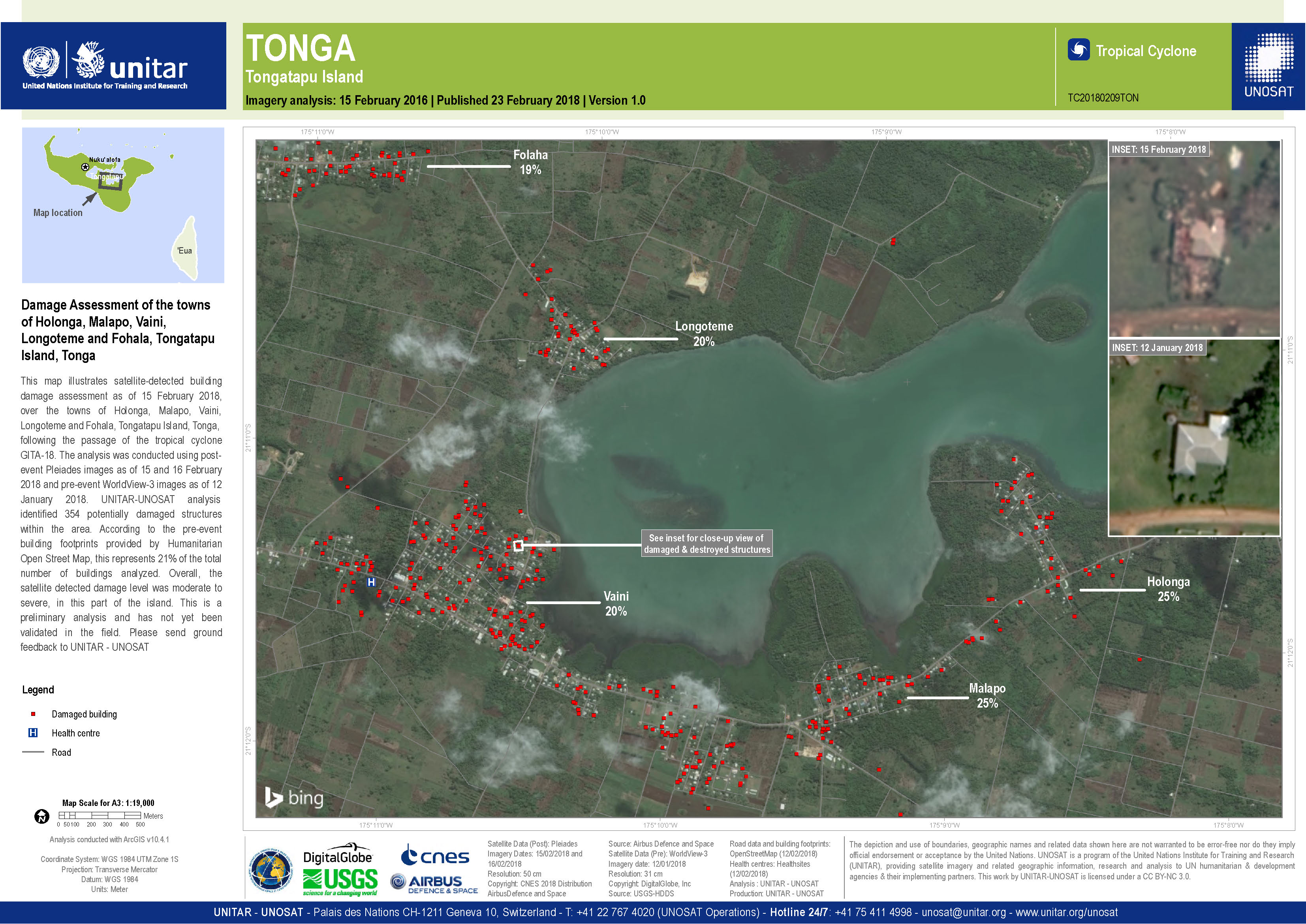
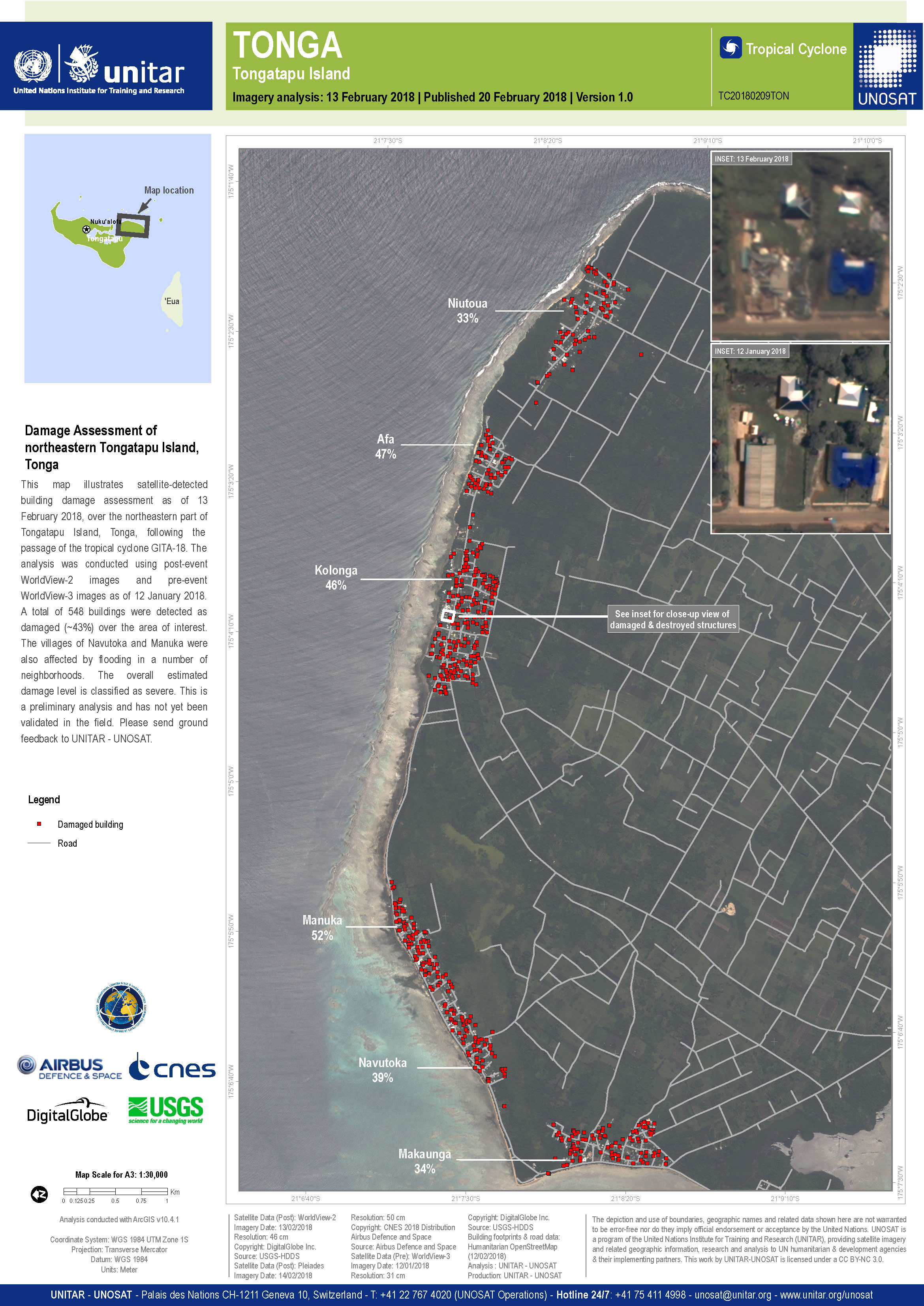
Evaluación de daños de las ciudades de Holonga, Malapo, Vaini, Longoteme y Fohala, isla de Tongatapu
Copyright: WorldView-3 © DigitalGlobe Inc.
Pleiades © CNES (2018) - Distribución: Airbus Defence and Space, reservados todos los derechos
Mapa producido por UNITAR/UNOSAT
Information about the Product
Acquired: WorldView-3: 12/01/2018
Pleiades: 15/02/2018
Source: WorldView-3 / Pleiades
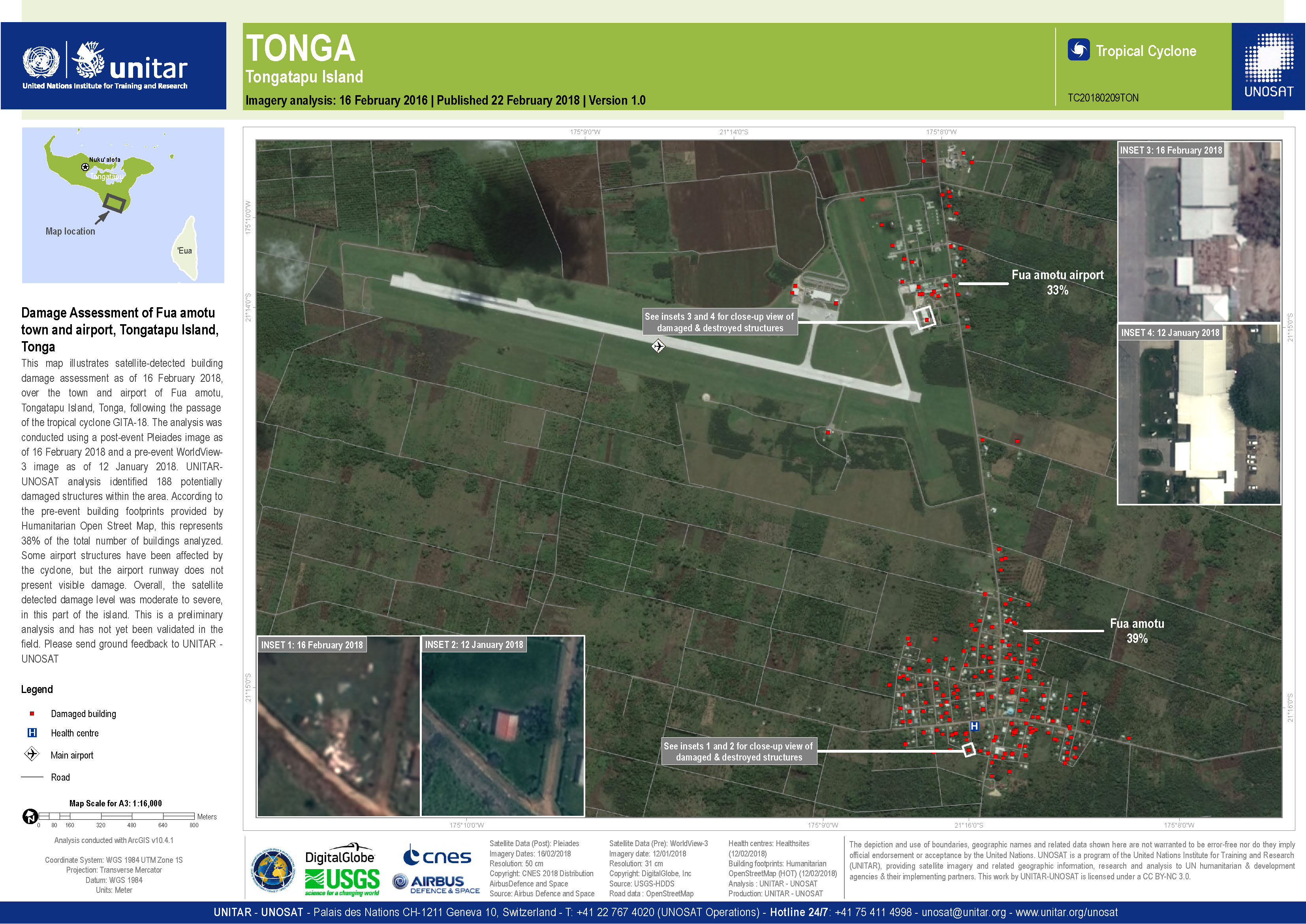
Evaluación de daños de la ciudad y el aeropuerto de Fua Amotu, Tongatapu Island
Copyright: WorldView-3 © DigitalGlobe Inc.
Pleiades © CNES (2018) - Distribución: Airbus Defence and Space, reservados todos los derechos
Mapa producido por UNITAR/UNOSAT
Information about the Product
Acquired: WorldView-3: 12/01/2018
Pleiades: 16/02/2018
Source: WorldView-3 / Pleiades
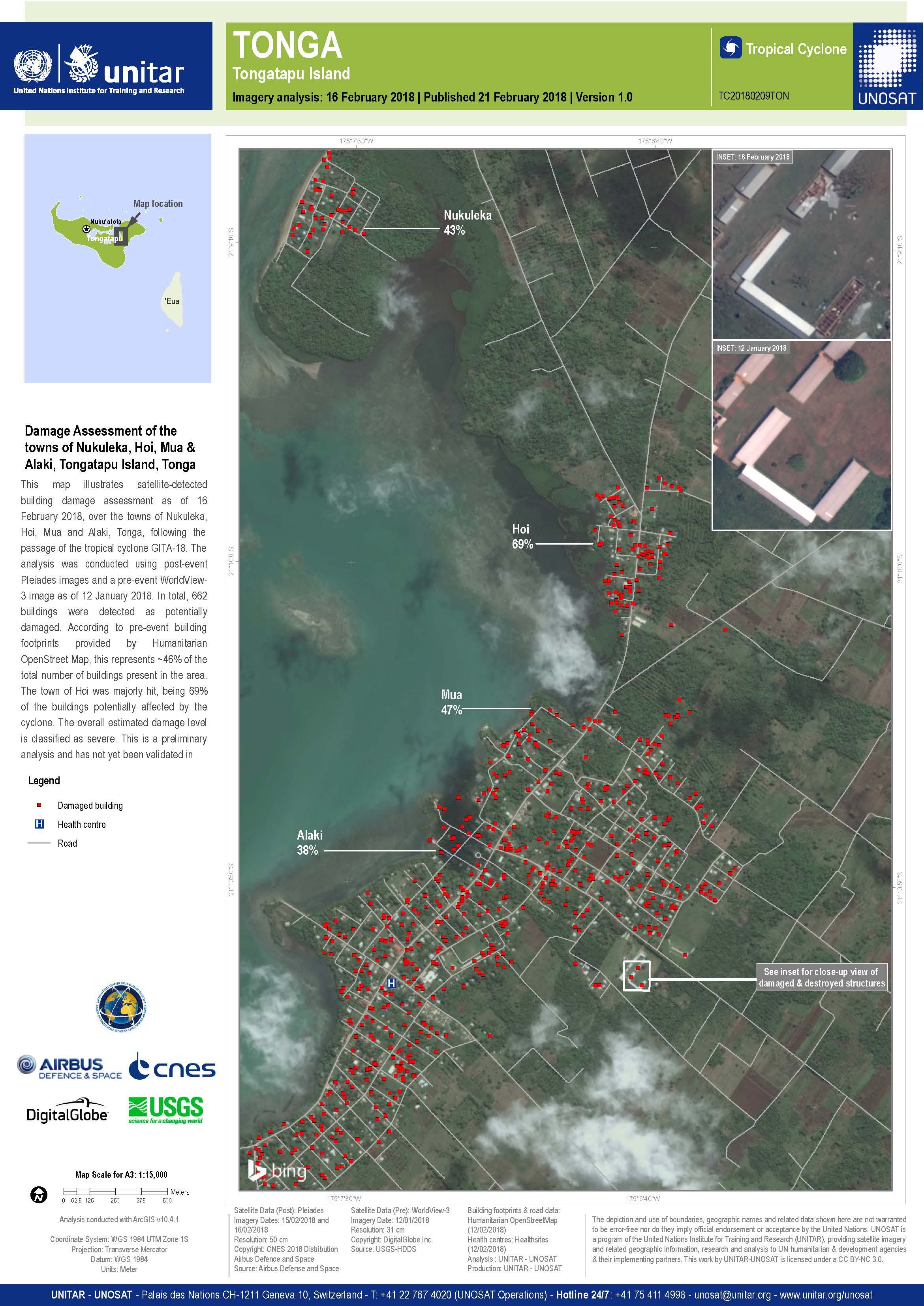
Evaluación de daños de las ciudades de Nukuleka, Hoi, Mua y Alaki, isla de Tongatapu
Copyright: WorldView-3 © DigitalGlobe Inc.
Pleiades © CNES (2018) - Distribución: Airbus Defence and Space, reservados todos los derechos
Mapa producido por UNITAR/UNOSAT
Information about the Product
Acquired: WorldView-3: 12/01/2018
Pleiades: 15/02/2018 y 16/02/2018
Source: WorldView-3 / Pleiades
DaEvaluación de daños de la isla de Tongatapu
Copyright: WorldView-2 and -3 © DigitalGlobe Inc.
Pleiades © CNES (2018) - Distribución: Airbus Defence and Space, reservados todos los derechos
Mapa producido por UNITAR/UNOSAT
Information about the Product
Acquired: WorldView-2: 13/02/2018
WorldView-3: 12/01/2018
Pleiades: 14/02/2018
Source: WorldView-2 / WorldView-3 / Pleiades
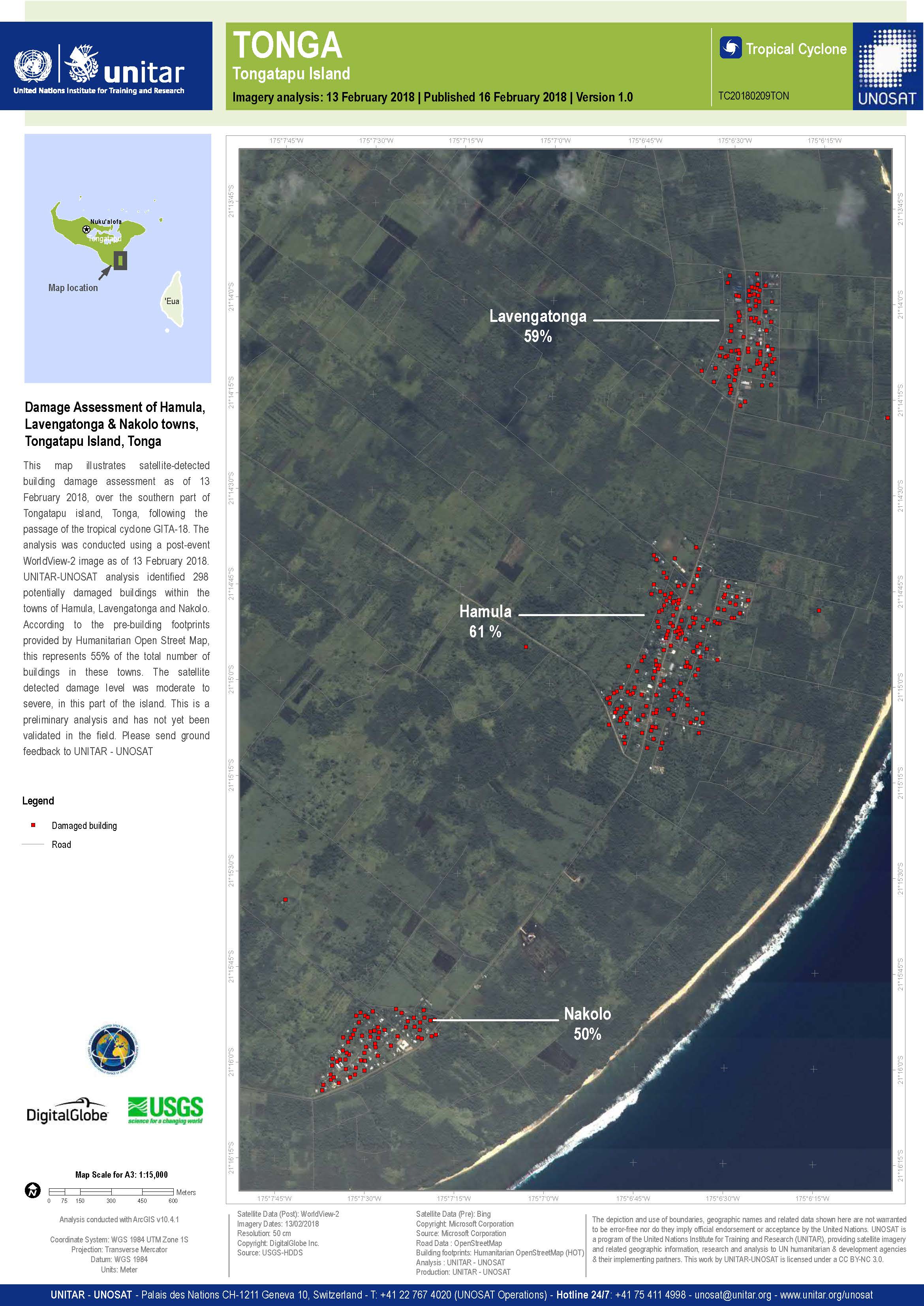
Evaluación de daños de Hamula, Ciudades de Lavengatonga y Nakolo
Copyright: WorldView-2 © DigitalGlobe Inc.
Mapa producido por UNITAR/UNOSAT
Information about the Product
Acquired: 13/02/2018
Source: WorldView-2
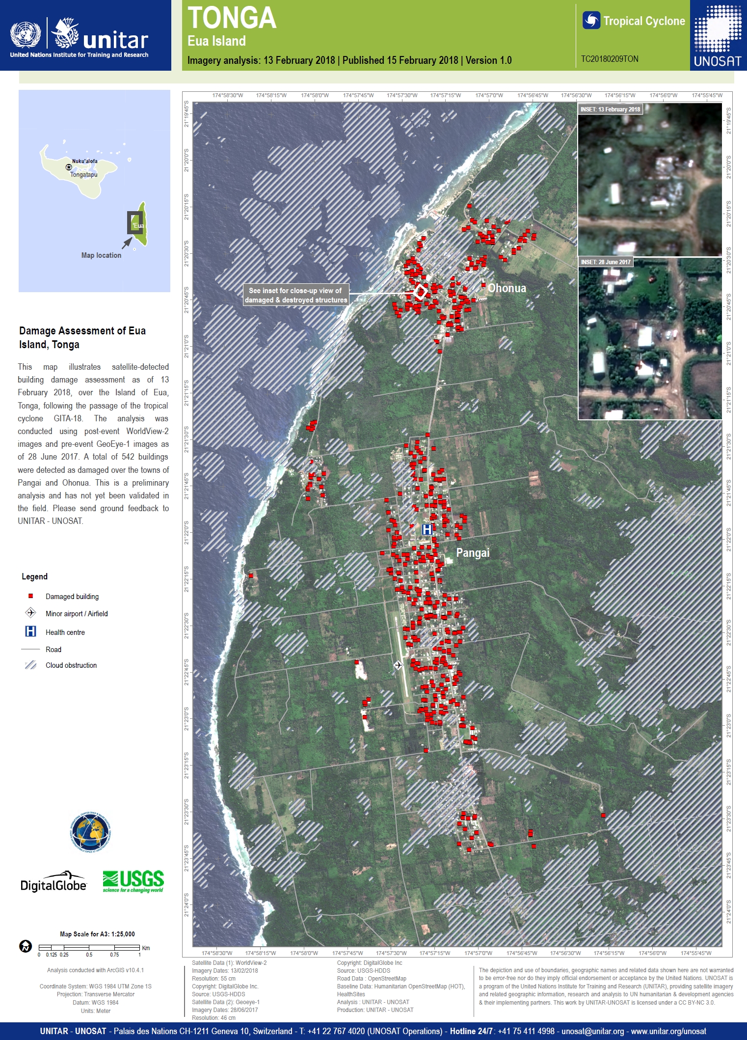
Damage assessment of Eua Island
Copyright: GeoEye-1 y WorldView-2 © DigitalGlobe Inc.
Mapa producido por UNITAR/UNOSAT
Information about the Product
Acquired: GeoEye-1: 28/06/2017
WorldView-2: 13/02/2018
Source: GeoEye-1 / WorldView-2
 Back to the full activation archive

