 English
 Spanish
 French
 Chinese
 Russian
 Portuguese
 Latest Activation
Charter activations
Cyclone Idai in Mozambique
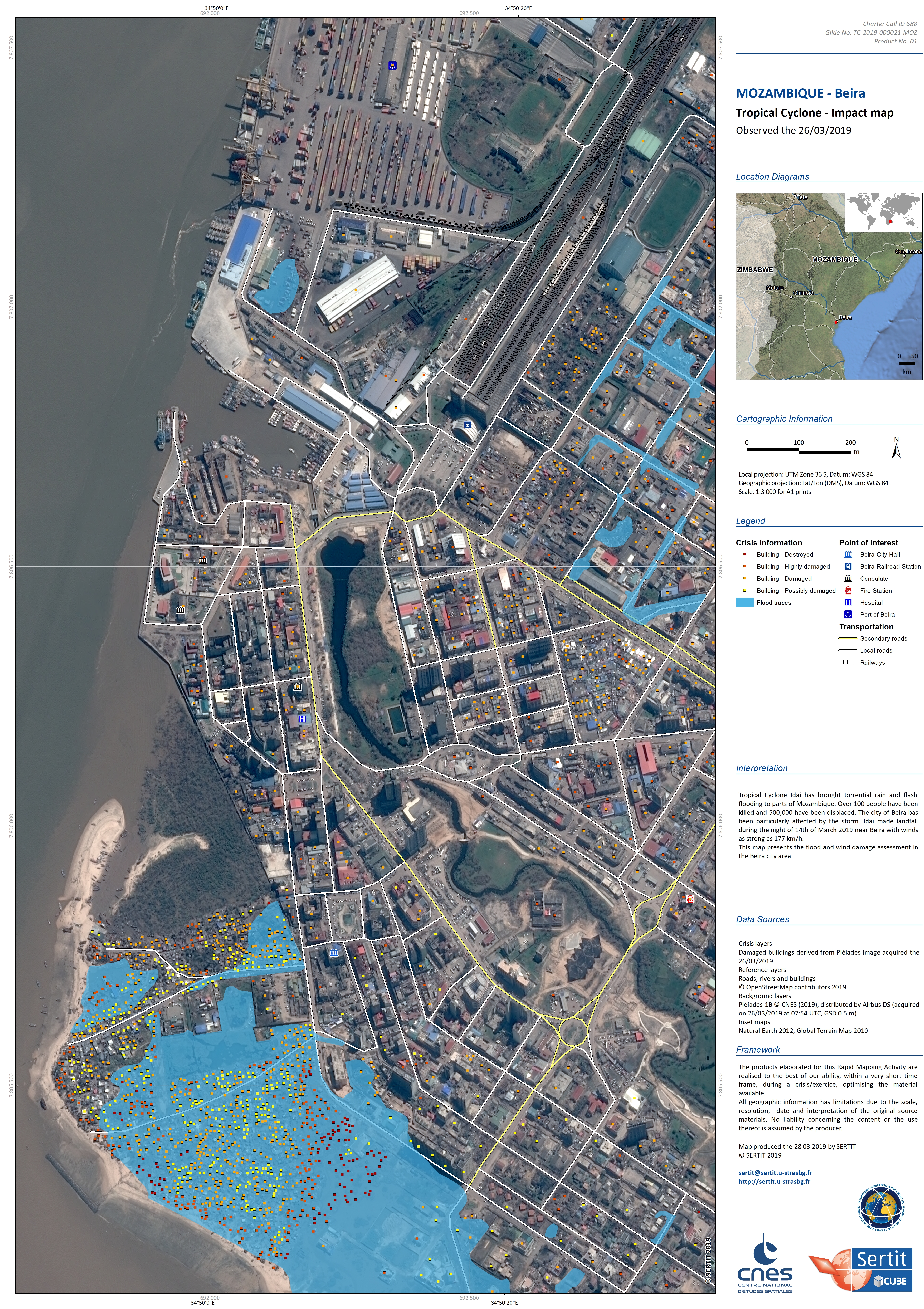
Tropical Cyclone Idai has brought torrential rain and flash flooding to parts of Mozambique. Over 100 people have been killed and 500,000 have been displaced. The high winds and heavy rainfall are expected to move over southern Malawi and Zimbabwe.
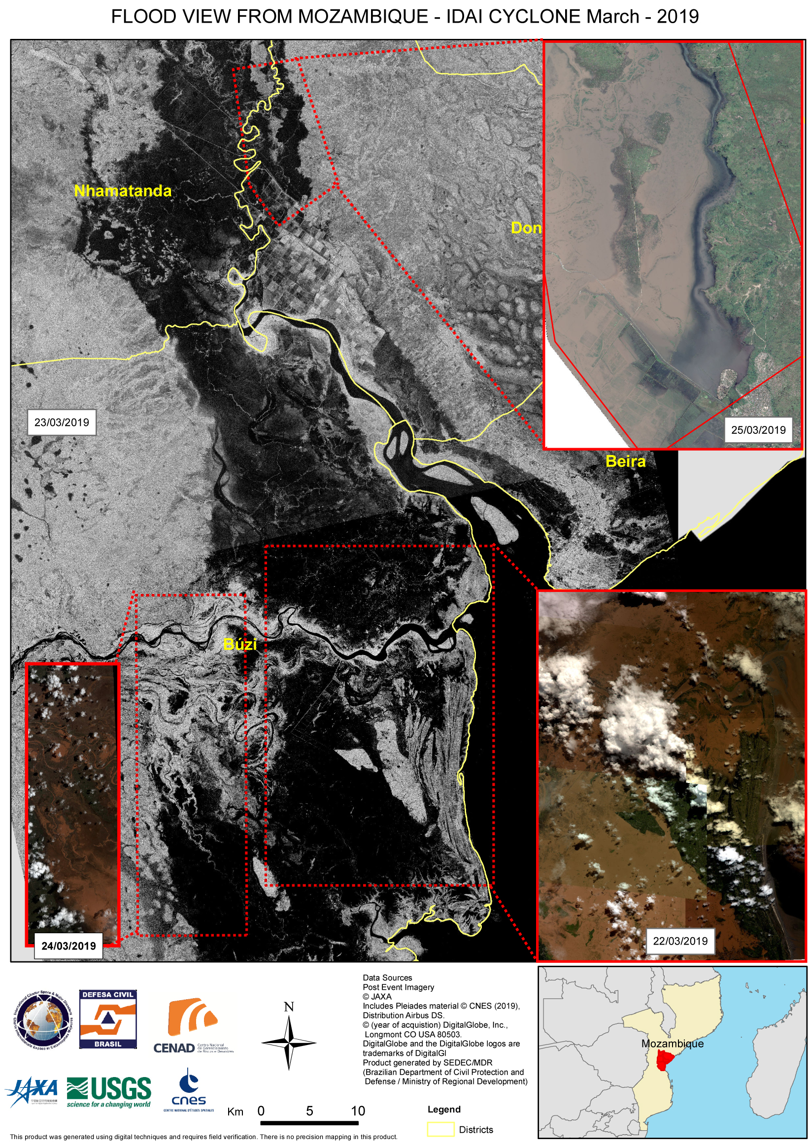
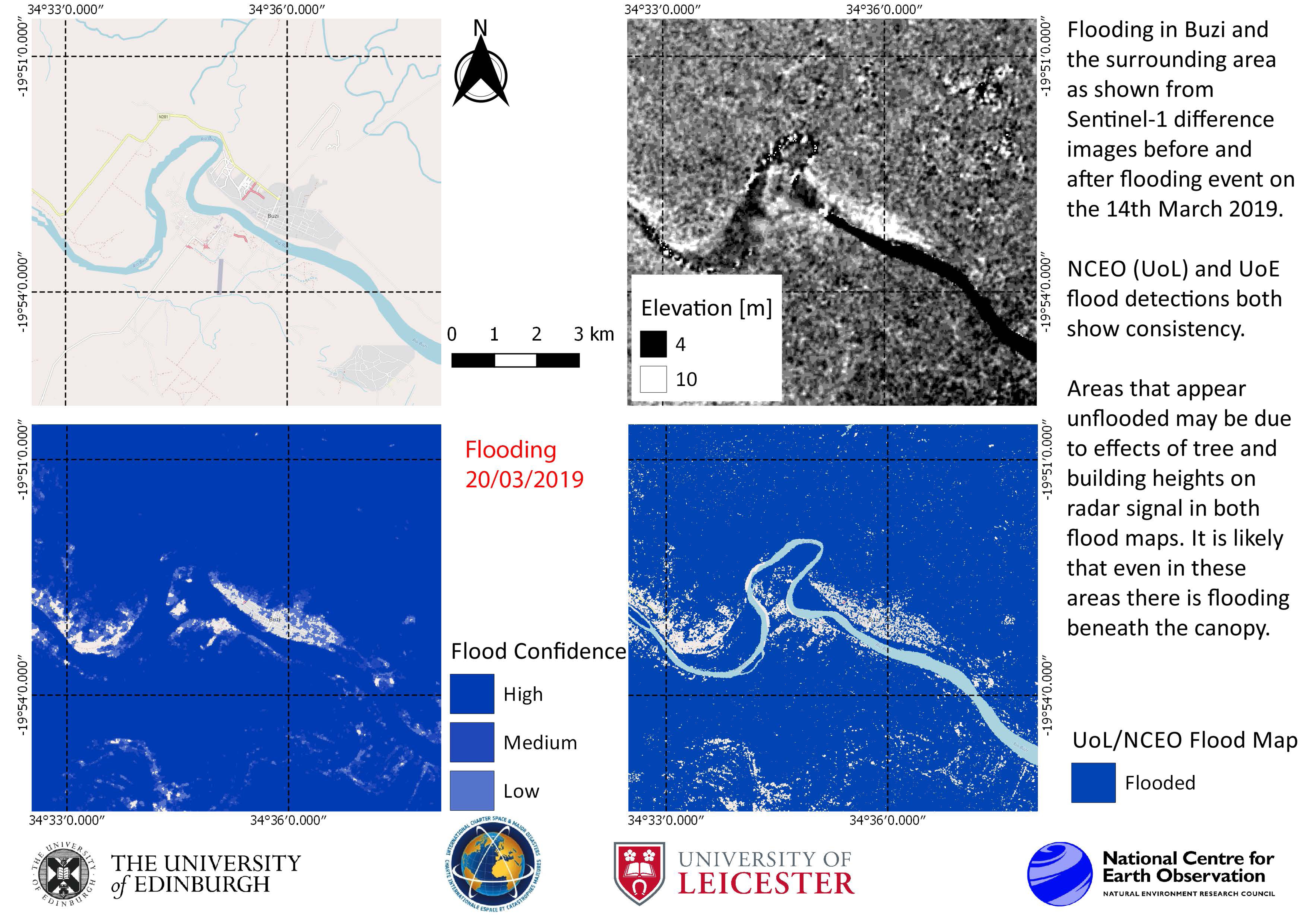
Storms have taken place for over a week, causing rivers - notably the Buzi River - to break their banks. The flooding has damaged power supplies and communications, leaving many people with electricity. The flooding has also affected water supplies.
With an estimated 5000 properties being submerged and large swathes of cropland destroyed, authorities have ordered mandatory evacuations of flooded and flood prone areas.
The city of Beira - capital of the Sofala province - and Buzi town have been particularly affected by the storm. Idai made landfall near Beira with winds as strong as 177 km/h and it is feared that Buzi may be entirely submerged by flood waters.
Reports indicate that the flood waters in Mozambique reach 6 metres in some areas.
Related News and Resources
| Tipo de evento: | Ocean Storm - Cyclone |
| Local do evento: | Mozambique |
| Data da Ativação da Carta: | 2019-03-14 |
| Tempo de Ativação da Carta: | 22:04 |
| Zona de Tempo da Ativação da Carta: | UTC-03:00 |
| Requisitante da Carta: | CENAD UNOSAT on behalf of IFRC |
| ID da Ativação: | 598 |
| Gerenciamento de projeto: | Ministério da Integração Nacional |
Products
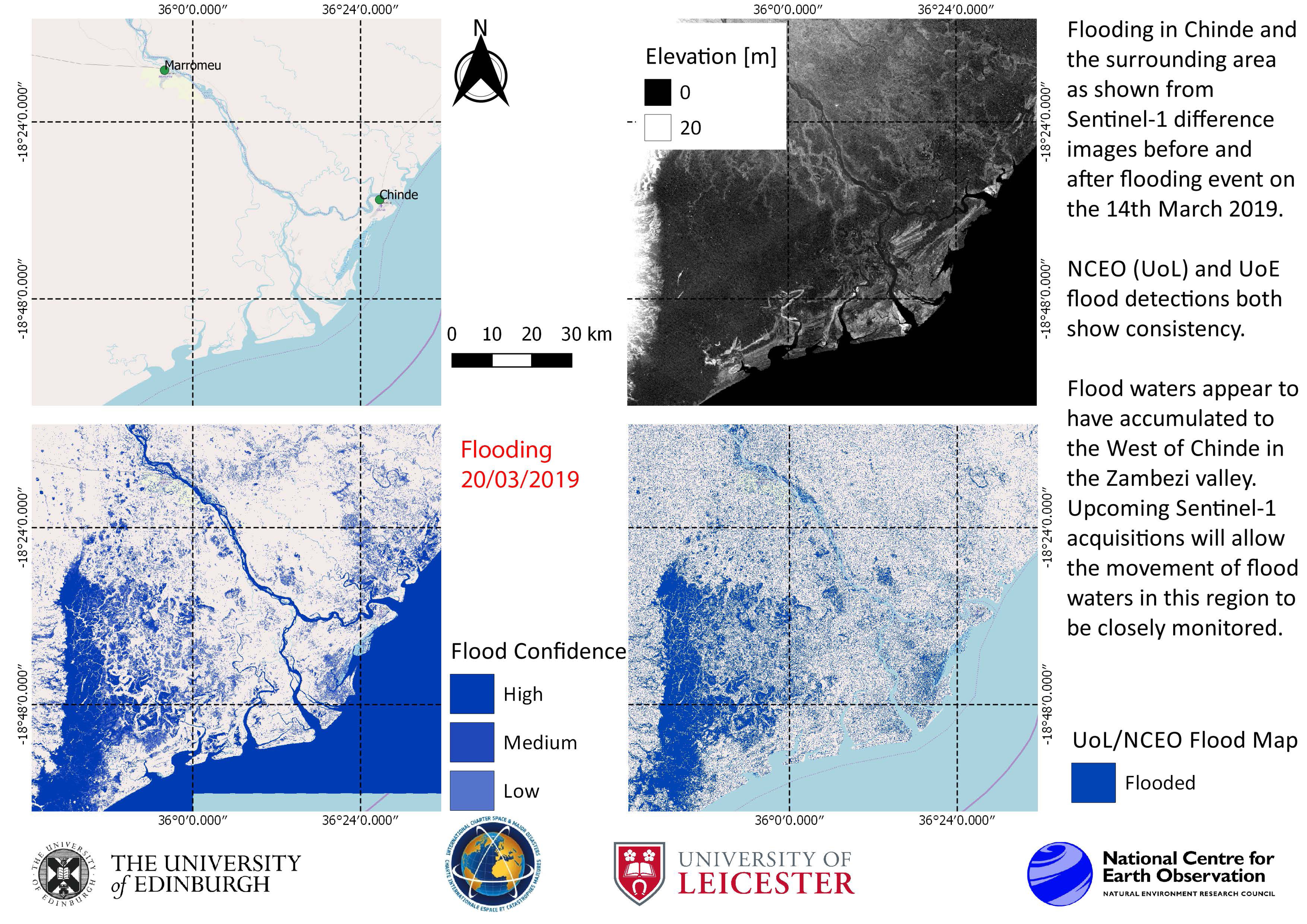
Satellite detected waters extents, as of 20 March 2019 over the Tete and Zambezia provinces, Mozambique
Direitos autorais: Contains modified Copernicus Sentinel data (2019)
Map produced by UNITAR/UNOSAT
Information about the Product
Adquirida: 25/01/2019 and 20/03/2019
Fonte: Sentinel-1
Population and settlement exposure analysis in Mozambique after Cyclone Idai - As of 18 March 2019
Download the full report
Direitos autorais: Report produced by UNITAR/UNOSAT
Information about the Product
Adquirida: 14/03/2019
Fonte: Sentinel-1
Total flood duration in Sofala, Mozambique between 15 and 25 March 2019
Direitos autorais: Sentinel-1 and -2 © Contains modified Copernicus Sentinel data (2019)
TerraSAR-X © DLR e. V. 2019, Distribution: Airbus DS Geo GmbH
Map produced by DLR/ZKI
Information about the Product
Adquirida: Sentinel-2: 02/12/2018 and 20/12/2018
Sentinel-1: 07/03/2019 - 25/03/2019
TerraSAR-X: 23/03/2019 and 24/03/2019
Fonte: Sentinel-1 / Sentinel-2 / TerraSAR-X
Flood regression in Sofala province, Mozambique
Direitos autorais: Sentinel-1 © Contains modified Copernicus Sentinel data (2019)
TerraSAR-X and TanDEM-X © DLR e. V. 2019, Distribution: Airbus DS Geo GmbH
Map produced by SEDEC/MDR
Information about the Product
Adquirida: Sentinel-1: 19/032019
TerraSAR-X and TanDEM-X: 23/03/2019
Fonte: Sentinel-1, TerraSAR-X and TanDEM-X
Flood extent in Sofala province, Mozambique
Direitos autorais: Contains modified Copernicus Sentinel data (2019)
Map produced by UNITAR/UNOSAT
Information about the Product
Adquirida: Pre-disaster: 25/01/2019
Post-disaster: 26/03/2019
Fonte: Sentinel-1
Estimation of potentially affected buildings in Cidade Da Beira district, Sofala province, Mozambique
Download the full report
Direitos autorais: Report produced by UNITAR/UNOSAT
Information about the Product
Adquirida: 19/03/2019
Fonte: GeoEye-1, Sentinel-1
Flood extent in Manica and Sofala provinces, Mozambique
Direitos autorais: Contains modified Copernicus Sentinel data (2019)
Map produced by UNITAR/UNOSAT
Information about the Product
Adquirida: 19/03/2019
Fonte: Sentinel-1
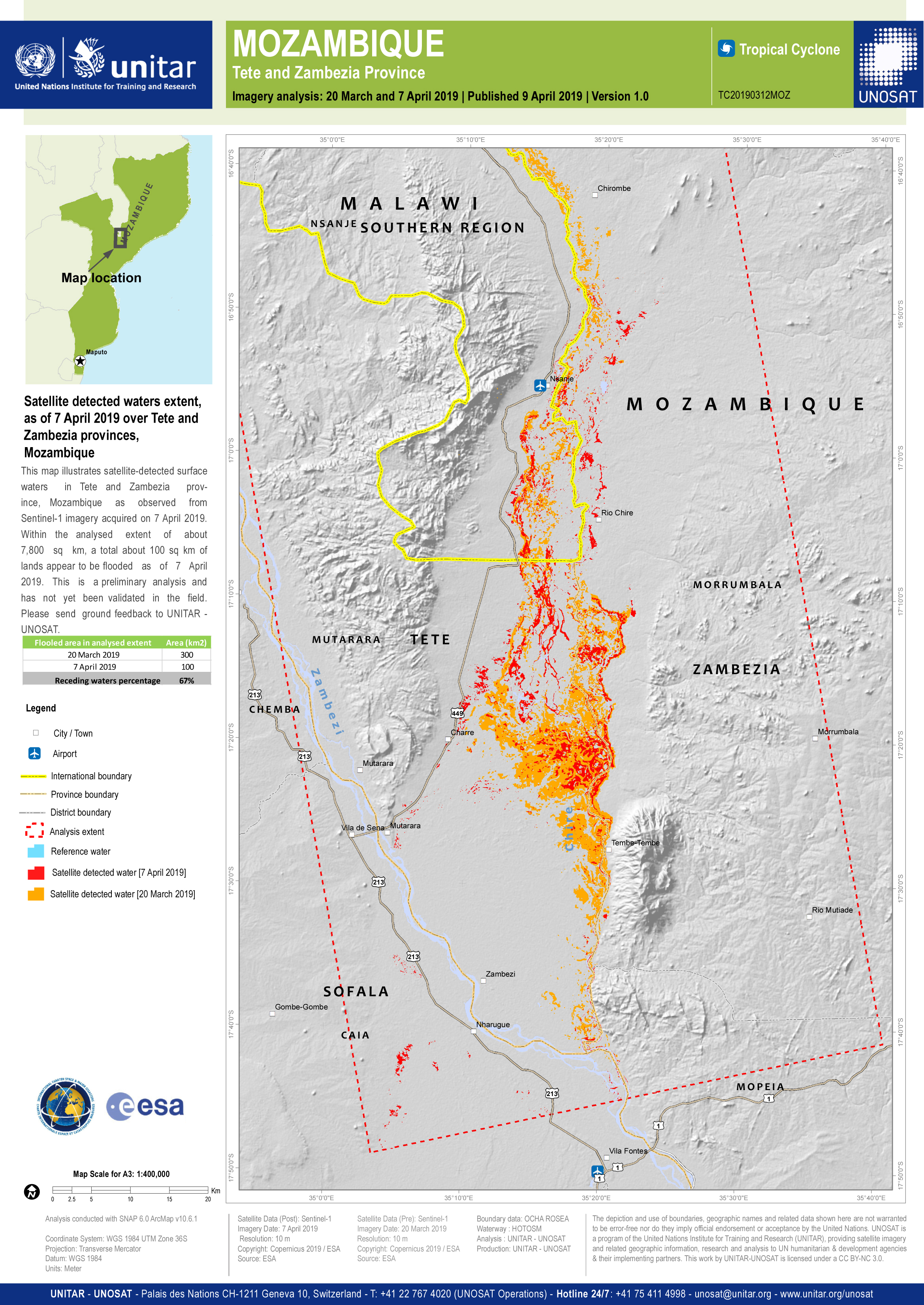
Flood extent in Tete and Zambezia provinces, Mozambique
Direitos autorais: Contains modified Copernicus Sentinel data (2019)
Map produced by UNITAR/UNOSAT
Information about the Product
Adquirida: Pre-disaster: 25/01/2019
Post-disaster: 20/03/2019
Fonte: Sentinel-1
Population and settlement exposure analysis in Mozambique after Cyclone Idai - As of 20 March 2019
Download the full report
Direitos autorais: Report produced by UNITAR/UNOSAT
Information about the Product
Adquirida: 20/03/2019
Flood extent in Sofala province, Mozambique
Direitos autorais: Contains modified Copernicus Sentinel data (2019)
Map produced by UNITAR/UNOSAT
Information about the Product
Adquirida: Pre-disaster: 18/01/2019 and 25/01/2019
Post-disaster: 19/03/2019 and 20/03/2019
Fonte: Sentinel-1
Population exposure analysis in Mozambique after Cyclone Idai - As of 12 March 2019
Download the full report
Direitos autorais: Report produced by UNITAR/UNOSAT
Information about the Product
Adquirida: 12/03/2019
Flood extent in Sofala province, Mozambique
Direitos autorais: Contains modified Copernicus Sentinel data (2019)
Map produced by UNITAR/UNOSAT
Information about the Product
Adquirida: Pre-disaster: 25/01/2019
Post-disaster: 13/03/2019 and 14/03/2019
Fonte: Sentinel-1
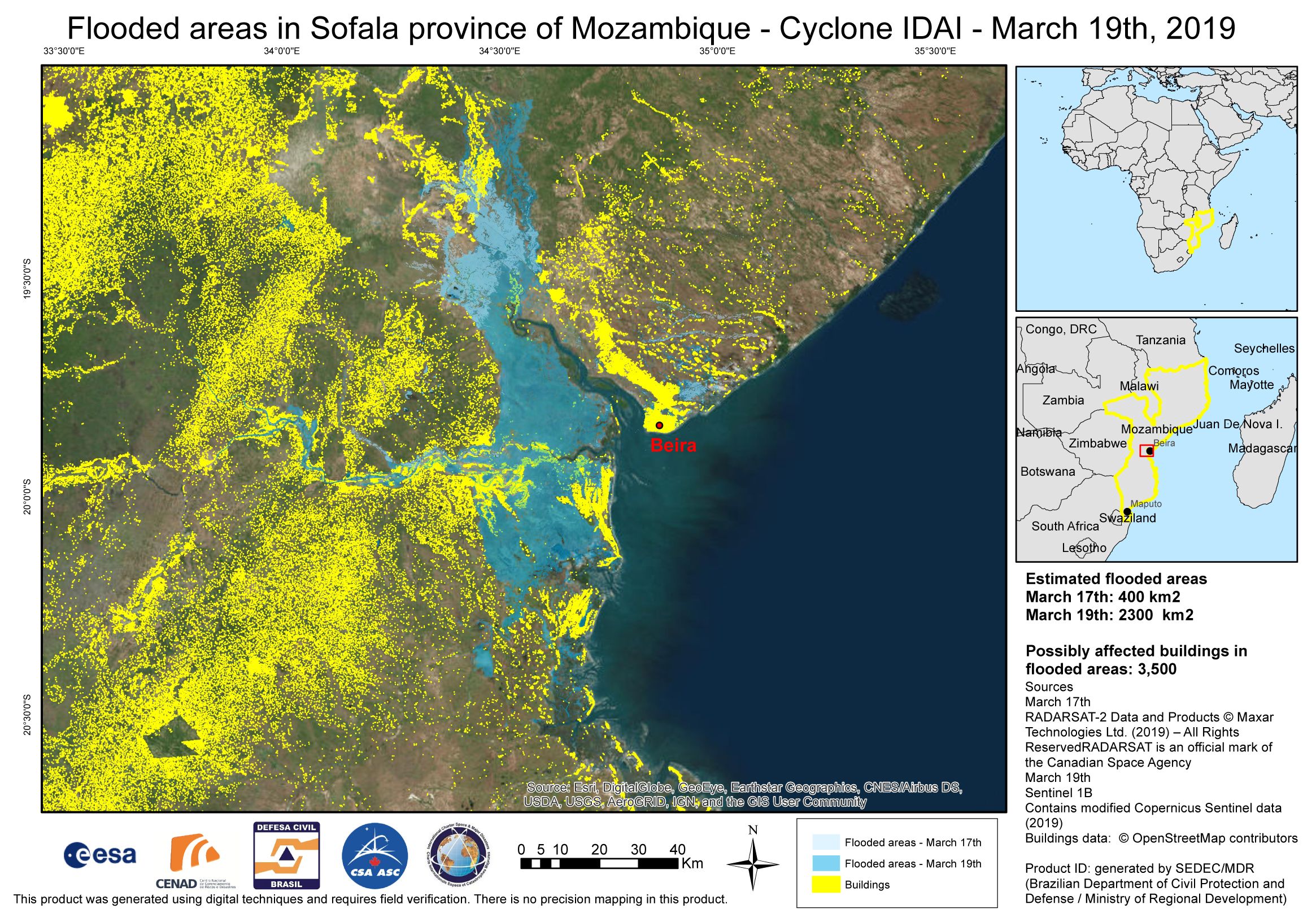
Flood areas in Sofala Province, Mozambique as of 19 March
Direitos autorais: RADARSAT-2 Data and Products © Maxar Technologies Ltd. (2019) - All Rights Reserved. RADARSAT is an official trademark of the Canadian Space Agency.
Sentinel-1 © Contains modified Copernicus Sentinel data (2019)
Map produced by SEDEC/MDR
Information about the Product
Adquirida: Sentinel-1: 19/03/2019
RADARSAT-2: 19/03/2019
Fonte: RADARSAT-2 / Sentinel-1
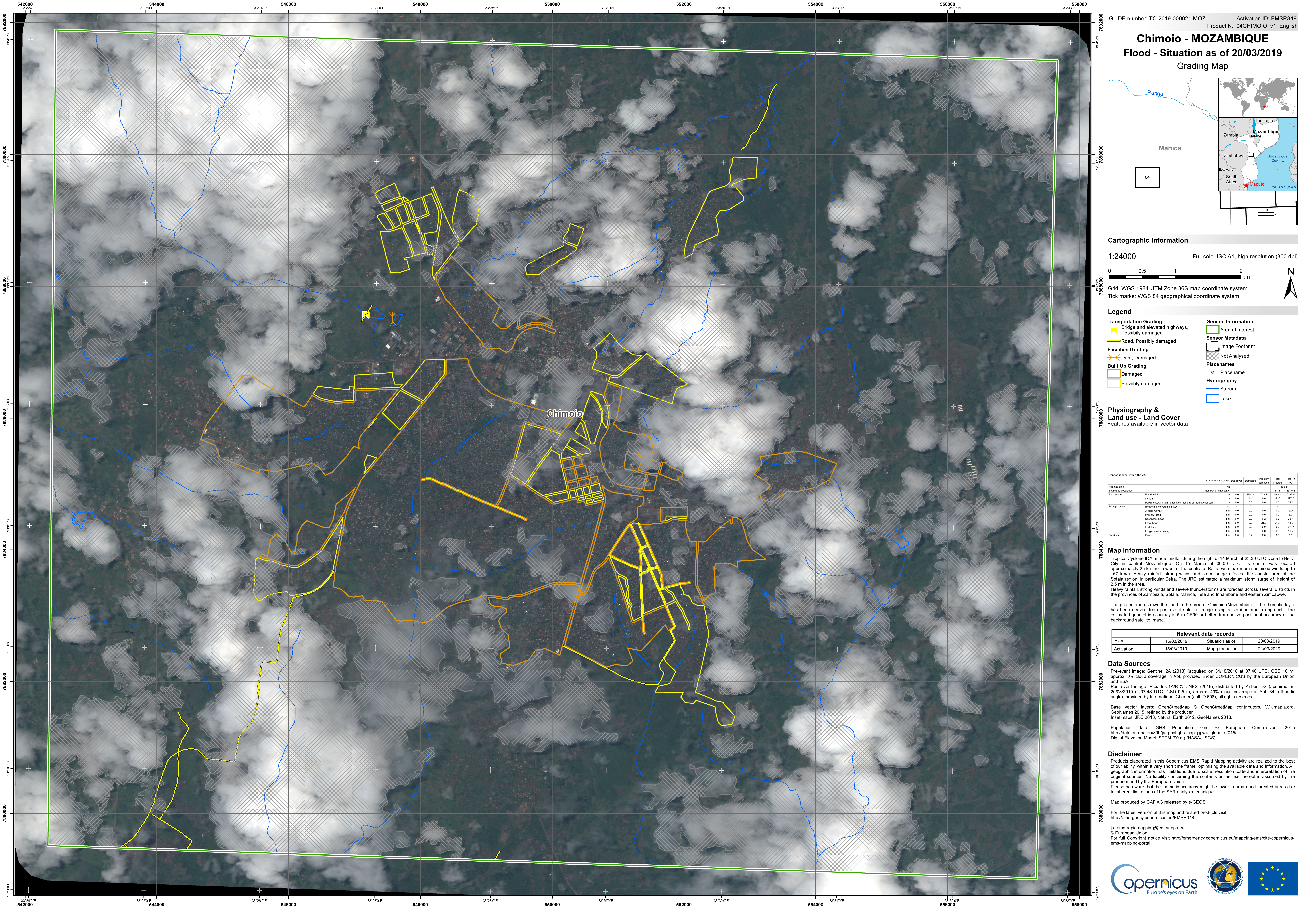
Chimoio, Mozambique: Situation map as of 20 March 2019
Direitos autorais: Sentinel- 2 © Contains modified Copernicus Sentinel data (2019)
Pleiades © CNES (2019) - Distribution: Airbus Defence and Space, all rights reserved
Map produced by Copernicus EMS
Information about the Product
Adquirida: Sentinel-2: 31/10/2018
Pleiades: 20/03/2019
Fonte: Sentinel-2 / Pleiades
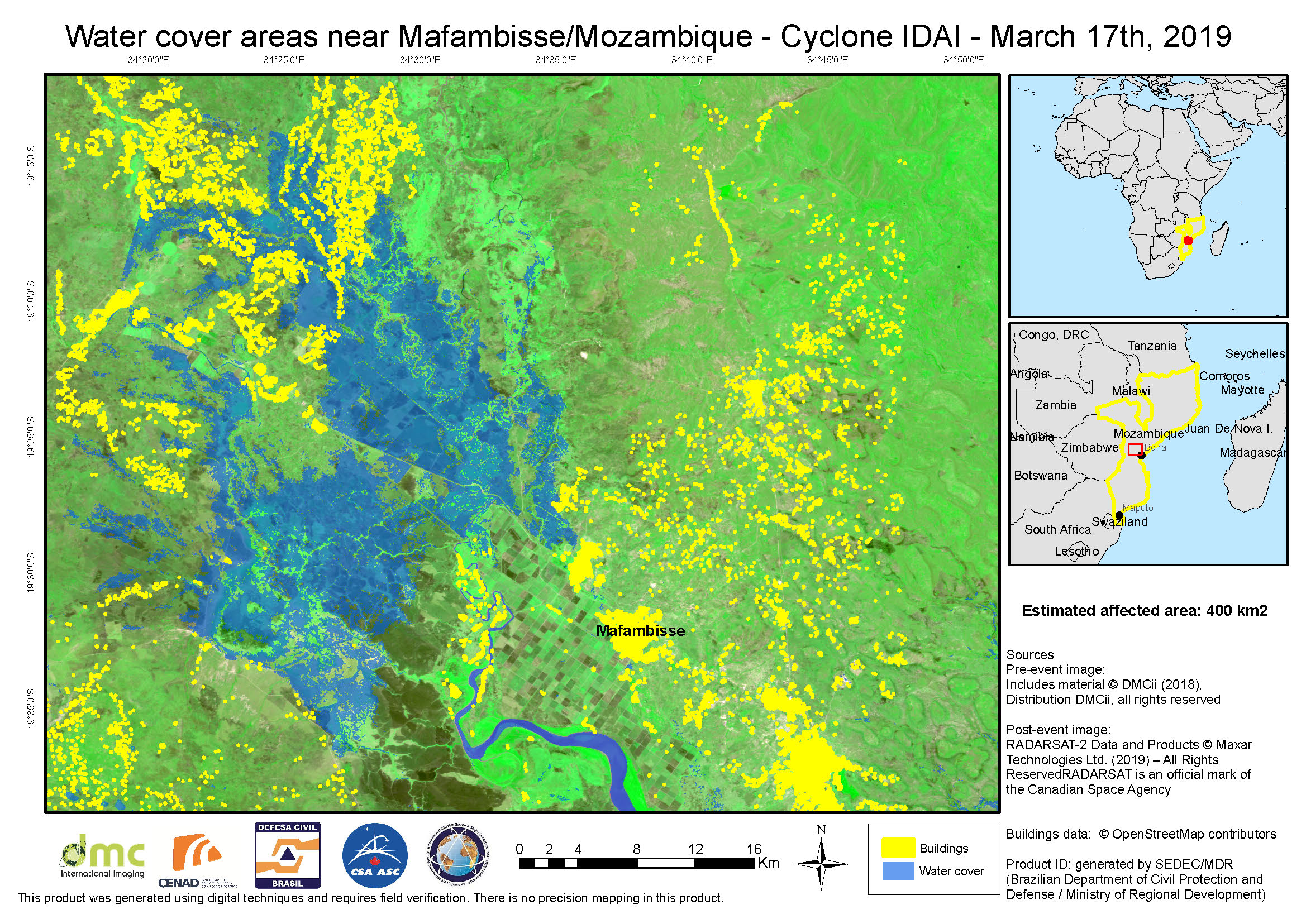
Water cover near Mafambisse in Mozambique after Cyclone Idai
Direitos autorais: UKSA 2018, distribution UKSA, all rights reserved
RADARSAT-2 Data and Products © Maxar Technologies Ltd. (2019) - All Rights Reserved. RADARSAT is an official trademark of the Canadian Space Agency.
Map produced by Brazilian Department of Civil Protection and Defense
Information about the Product
Adquirida: 17/03/2019
Fonte: DMC / RADARSAT-2
 Voltar ao arquivo completo da Ativação

