 English
 Spanish
 French
 Chinese
 Russian
 Portuguese
 Dernière activation
Charter activations
Flooding in Venezuela
Flooding occurred in Las Tejerias, Aragua State central Venezuela due to heavy rains. The downpour swept large tree trunks and debris from surrounding mountains damaging businesses and farmland.
Official reports reported at least 35 people died, 52 missing, 317 houses destroyed and 757 properties affected. 10,000 homes were without water service and a stable electrical power service in the area.
| Type of Event: | Floods |
| Location of Event: | Venezuela, Bolivarian Republic Of |
| Date of Charter Activation: | 2022-10-10 |
| Time of Charter Activation: | 20:01 |
| Time zone of Charter Activation: | UTC-04:00 |
| Charter Requestor: | Civil Protection of Venezuela |
| Activation ID: | 785 |
| Project Management: | PM_ABAE PM_ABAE (ABAE) |
| act-value-adders: | Samir Belabbes (UNITAR) |
Products
Delineation of affected areas by flooding - El Castano SAR image
Copyright: GF-3 © CNSA/CRESDA (2022)
Includes Pleiades material © CNES (2022), Distribution Airbus DS.
Map produced by ABAE
Information about the Product
Acquired: Pleiades: 19/10/2022
GF-3: 22/10/2022
Source: GF-3 / Pleiades
Category: Delineation Monitoring Maps


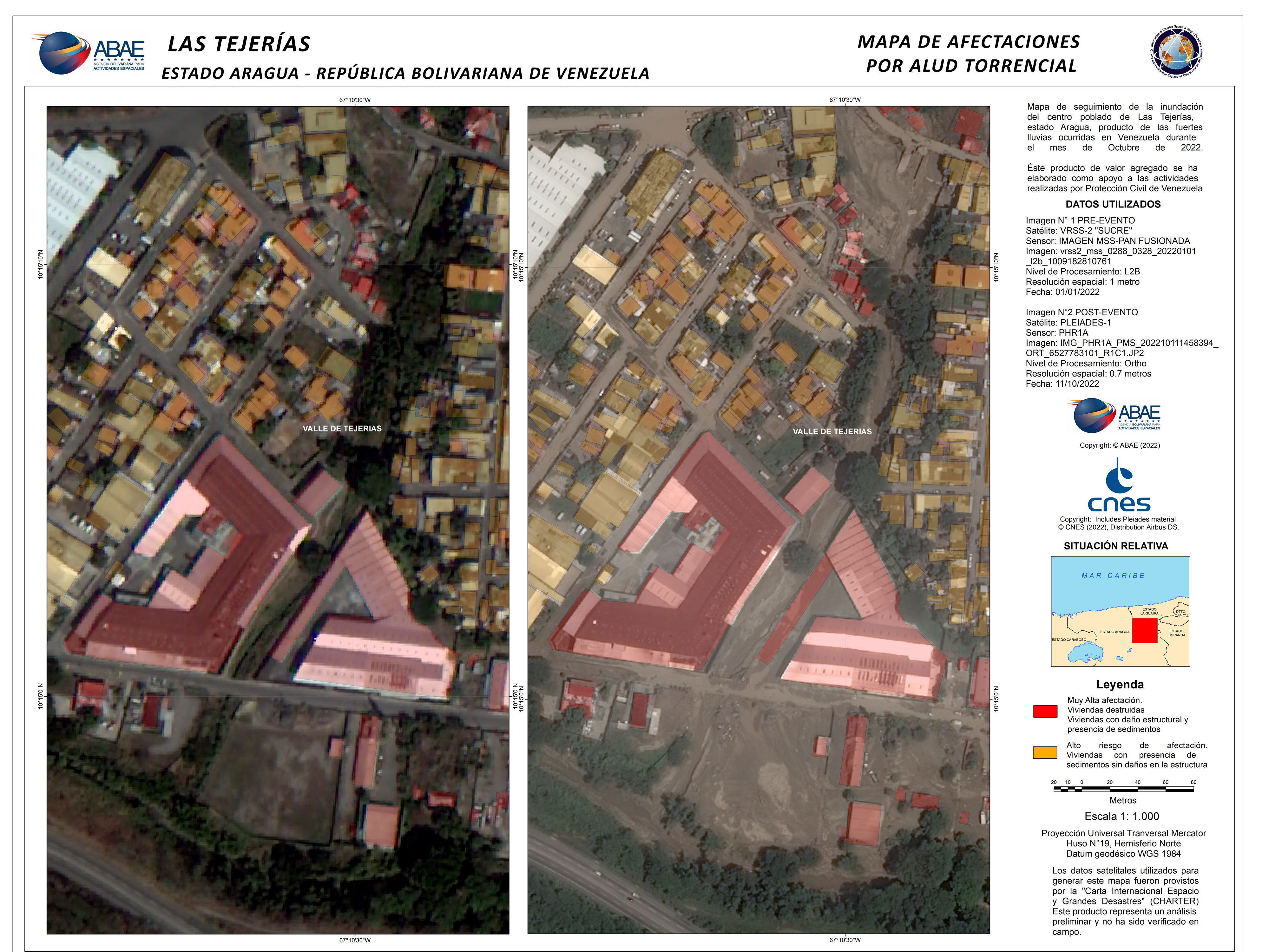
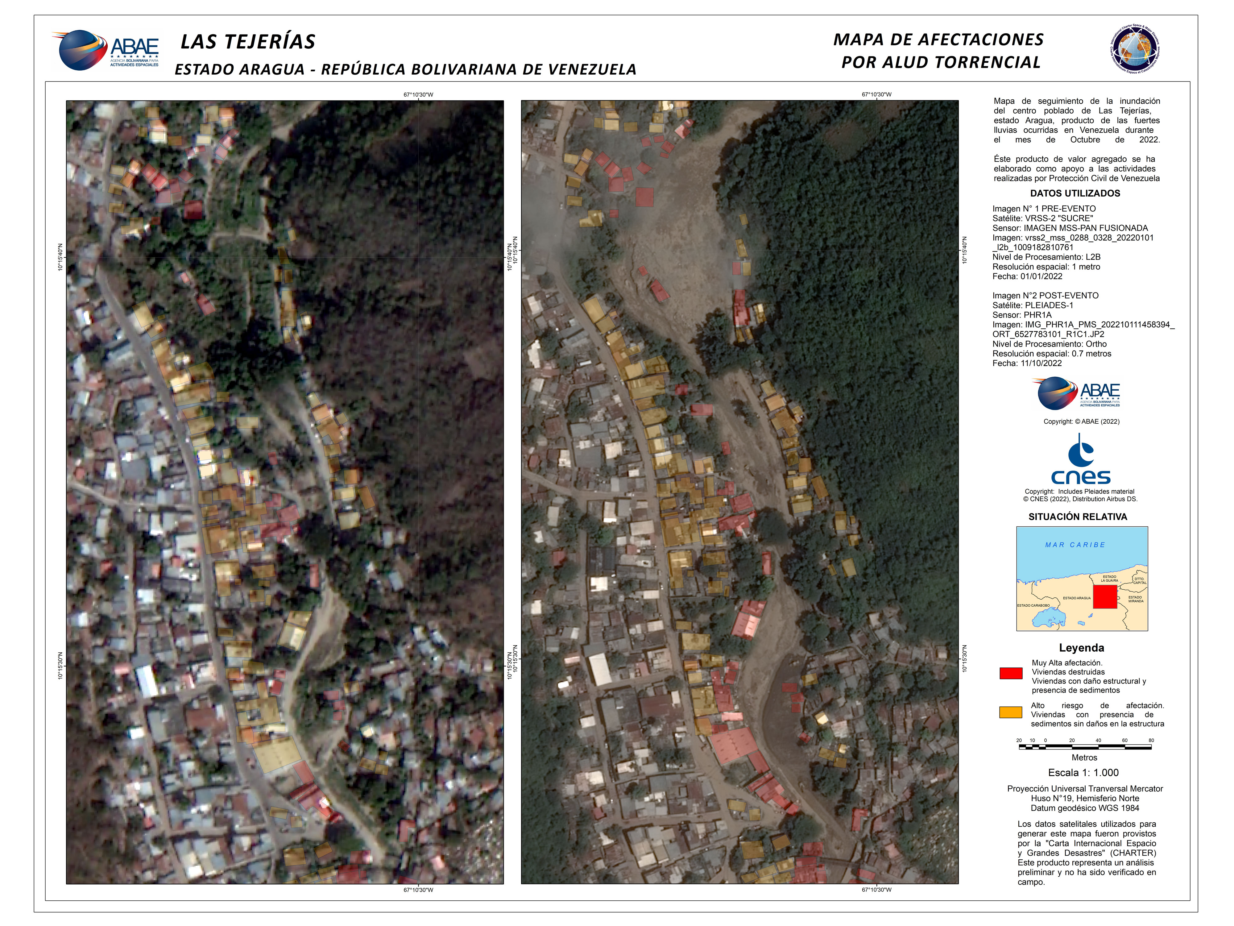
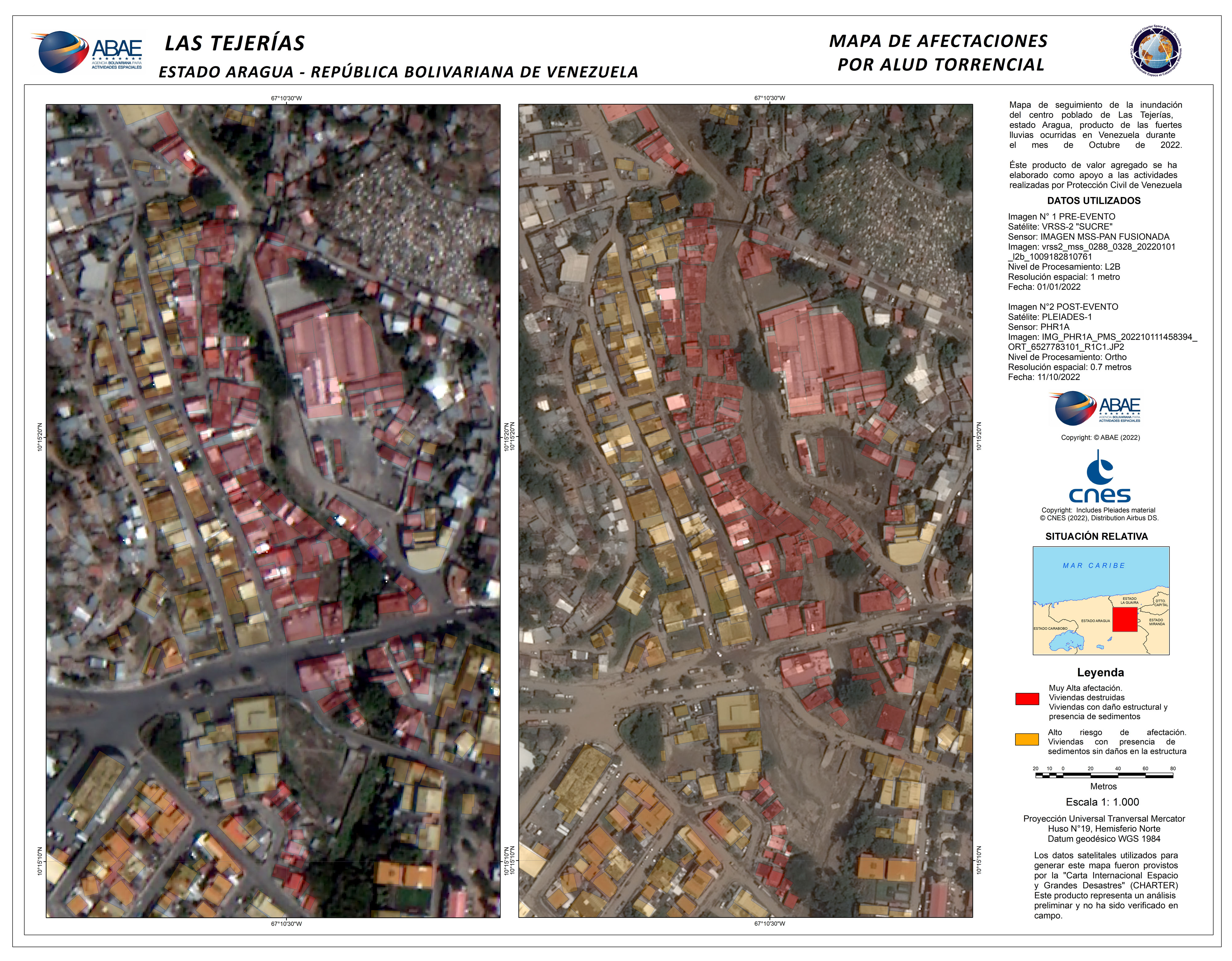
Las Tejerias Zona Industrial sector affected buildings and housing
Copyright: Includes Pleiades material © CNES (2022), Distribution Airbus DS.
VRSS-2 © ABAE (2022). All Rights Reserved
Map produced by ABAE
Information about the Product
Acquired: VRSS-2: 01/01/2022
Pleiades: 11/10/2022
Source: VRSS-2 / Pleiades
Category: Delineation Monitoring Maps
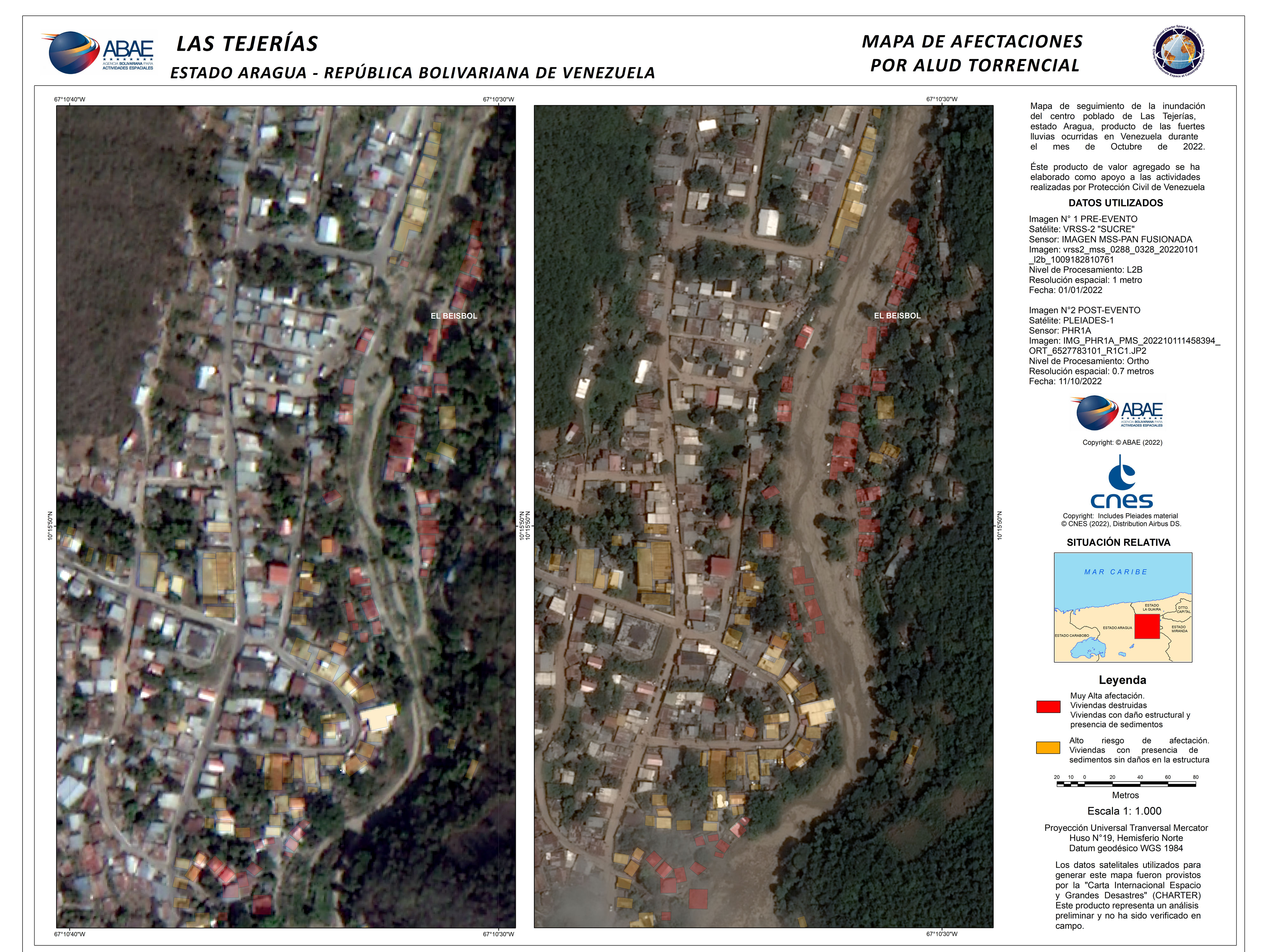
Las Tejerias El Beisbol sector affected buildings and housing
Copyright: Includes Pleiades material © CNES (2022), Distribution Airbus DS.
VRSS-2 © ABAE (2022). All Rights Reserved
Map produced by ABAE
Information about the Product
Acquired: VRSS-2: 01/01/2022
Pleiades: 11/10/2022
Source: VRSS-2 / Pleiades
Category: Delineation Monitoring Maps
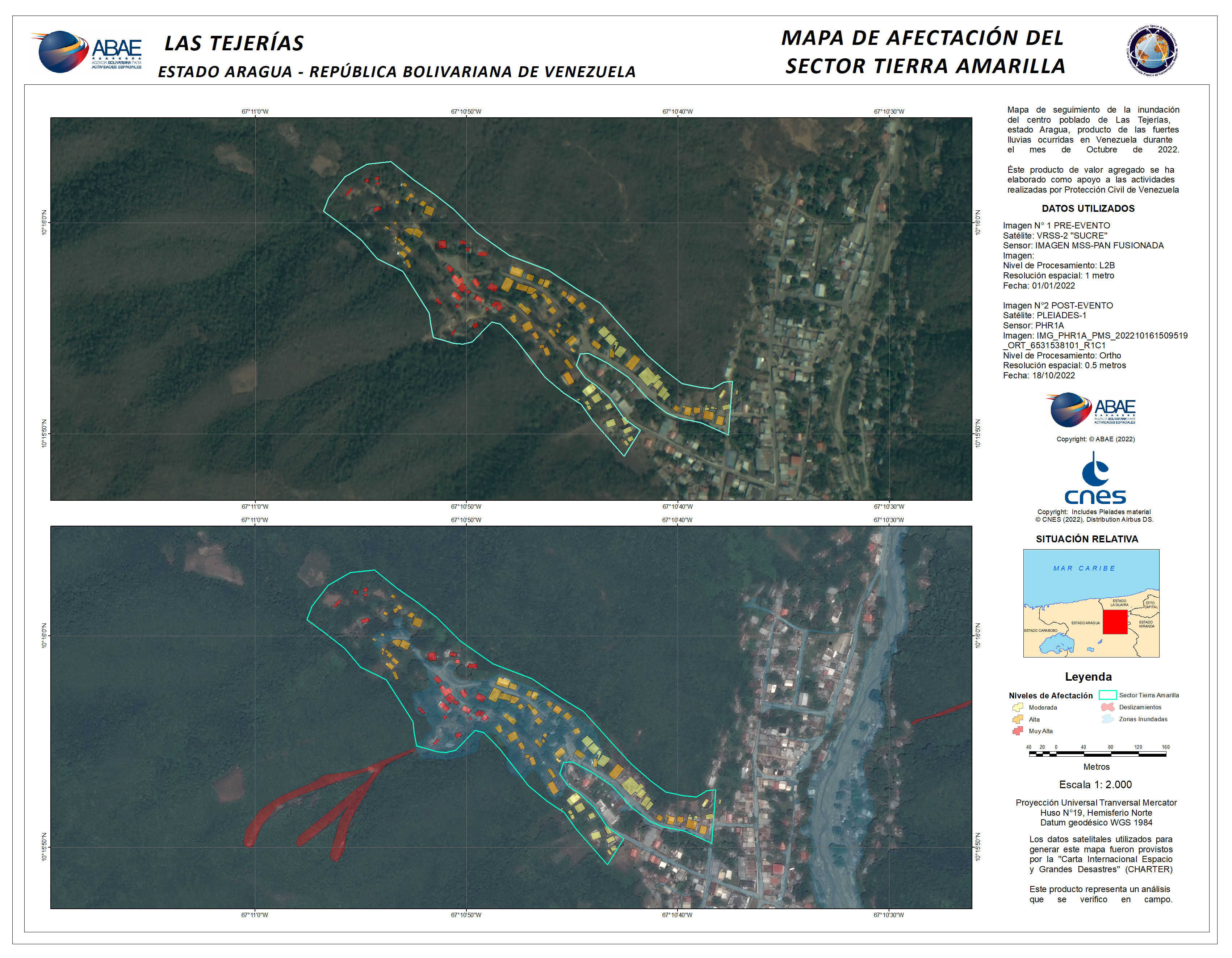
Las Tejerias Tierra Amarilla sector affected buildings and housing
Copyright: Includes Pleiades material © CNES (2022), Distribution Airbus DS.
VRSS-2 © ABAE (2022). All Rights Reserved
Map produced by ABAE (2022)
Information about the Product
Acquired: Pleiades: 18/10/2022
VRSS-2: 01/01/2022
Source: Pleiades / VRSS-2
Category: Delineation Monitoring Maps
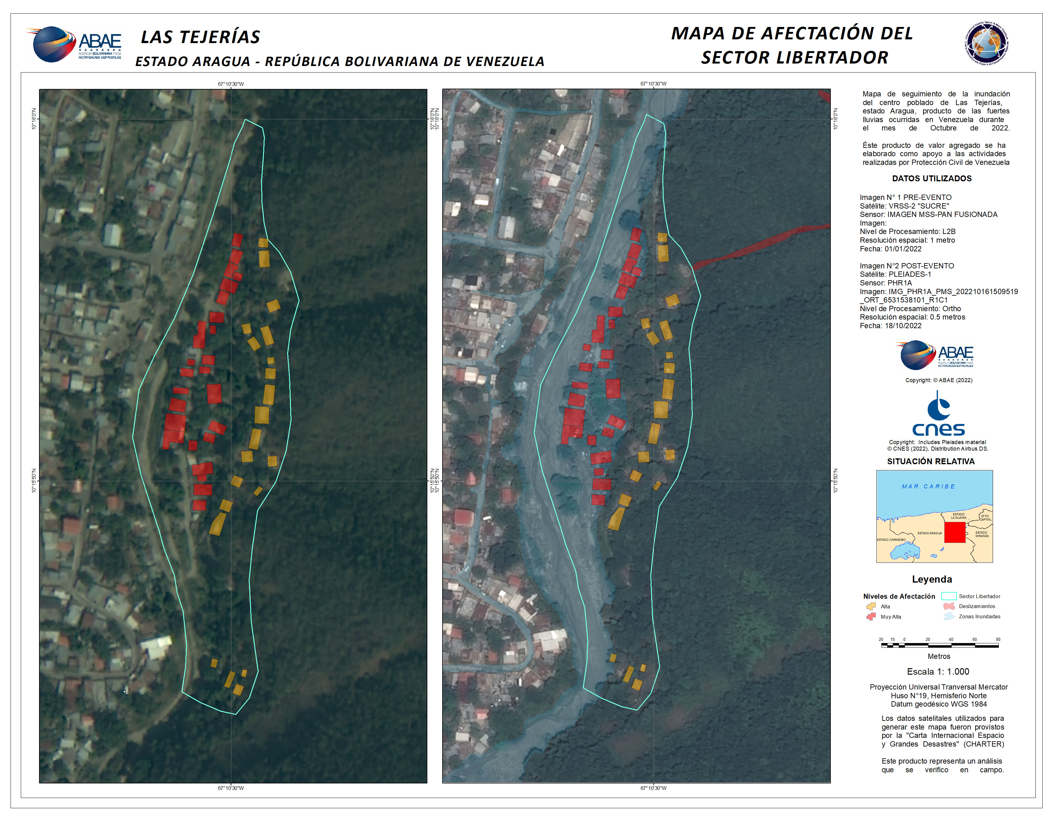
Las Tejerias Libertador sector affected buildings and housing
Copyright: Includes Pleiades material © CNES (2022), Distribution Airbus DS.
VRSS-2 © ABAE (2022). All Rights Reserved
Map produced by ABAE
Information about the Product
Acquired: VRSS-2: 01/01/2022
Pleiades: 18/10/2022
Source: VRSS-2 / Pleiades
Category: Delineation Monitoring Maps
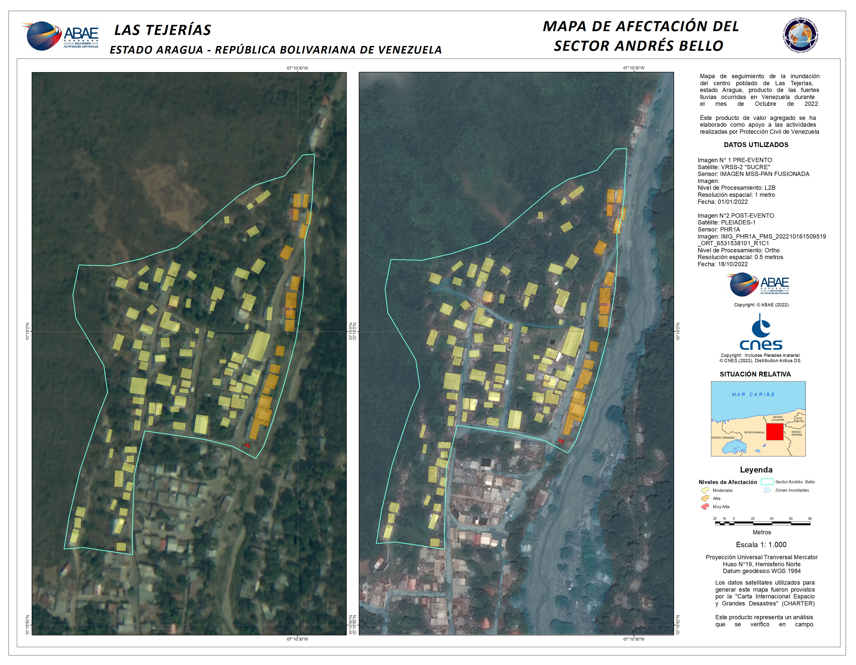
Las Tejerias Andres Bello sector affected buildings and housing
Copyright: Includes Pleiades material © CNES (2022), Distribution Airbus DS.
VRSS-2 © ABAE (2022). All Rights Reserved
Map produced by ABAE
Information about the Product
Acquired: VRSS-2: 01/01/2022
Pleiades: 18/10/2022
Source: VRSS-2 / Pleiades
Category: Reference Map
Las Tejerias northern area affected buildings and housing
Copyright: Includes Pleiades material © CNES (2022), Distribution Airbus DS.
VRSS-2 © ABAE (2022). All Rights Reserved
Map produced by ABAE
Information about the Product
Acquired: VRSS-2: 01/01/2022
Pleiades: 11/10/2022
Source: VRSS-2 / Pleiades
Category: Delineation Monitoring Maps
Las Tejerias town center affected buildings and housing
Copyright: Includes Pleiades material © CNES (2022), Distribution Airbus DS.
VRSS-2 © ABAE (2022). All Rights Reserved
Map produced by ABAE
Information about the Product
Acquired: Pleiades: 11/10/2022
VRSS-2: 01/01/2022
Source: Pleiades / VRSS-2
Category: Delineation Monitoring Maps

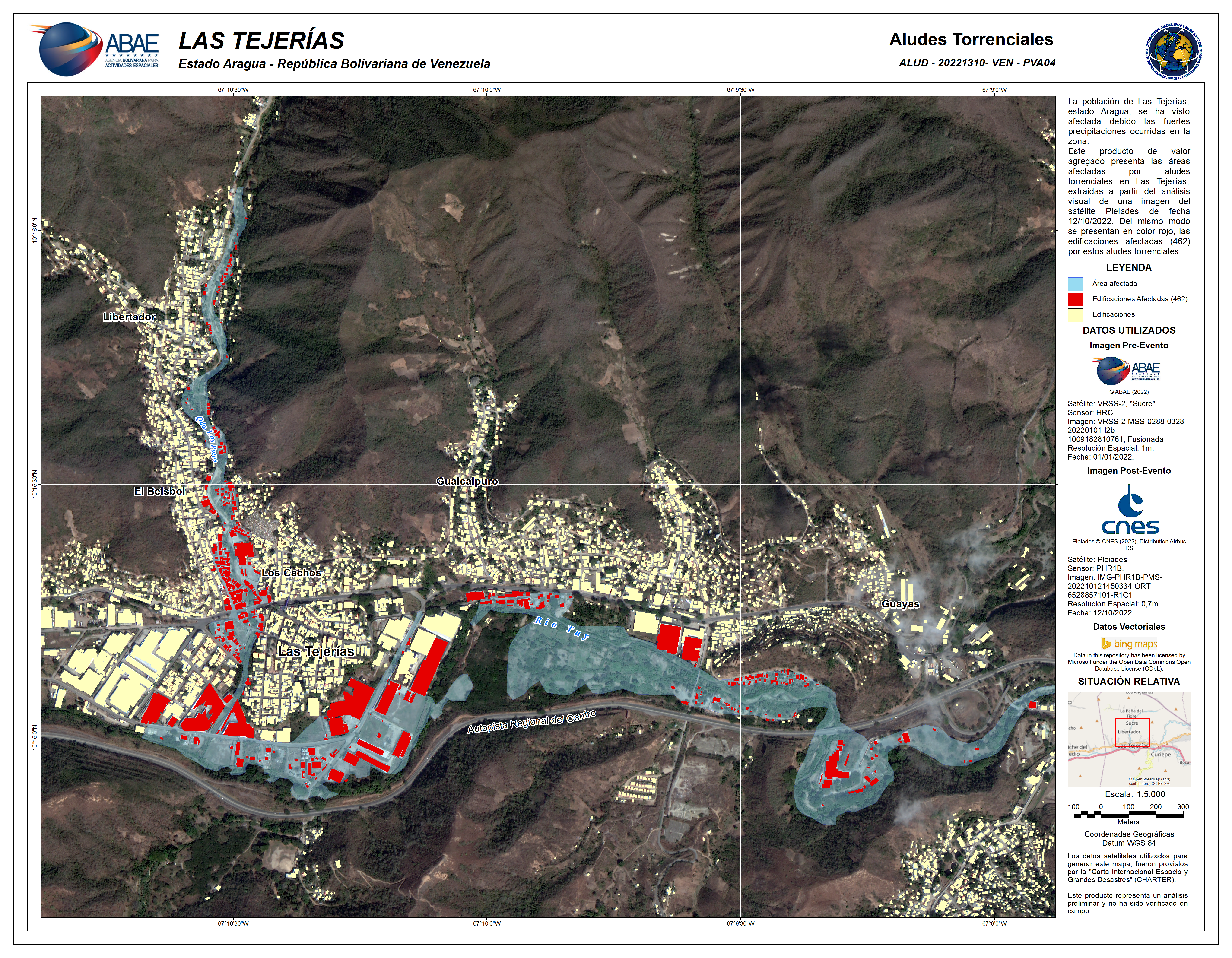
Basin, river course and affected areas of Las Tejerias
Copyright: Includes Pleiades material © CNES (2022), Distribution Airbus DS.
NewSat © Satellogic (2022)
Map produced by ABAE
Information about the Product
Acquired: NewSat: 11/10/2022
Pleiades: 16/10/2022
Source: Pleiades, NewSat
Category: Delineation Monitoring Maps
Affected buildings by flooding in Las Tejerias
Copyright: Includes Pleiades material © CNES (2022), Distribution Airbus DS.
VRSS-2 © ABAE (2022). All Rights Reserved
Map produced by ABAE
Information about the Product
Acquired: VRSS-2: 01/01/2022
Pleiades: 12/10/2022
Source: VRSS-2, Pleiades
Category: Reference Map
Delineation map over affected Las Tejerias areas
Copyright: VRSS-2 © ABAE (2022). All Rights Reserved
Contains modified Copernicus Sentinel data (2022)
Map produced by ABAE
Information about the Product
Acquired: VRSS-2: 01/01/2022
Sentinel-2: 11/10/2022
Source: VRSS-2 / Sentinel-2
Category: Delineation Monitoring Maps


Flooding in the Las Tejerias area of Venezuela
Copyright: Includes Pleiades material © CNES (2022), Distribution Airbus DS.
VRSS-2 © ABAE (2022). All Rights Reserved
Map produced by ABAE
Information about the Product
Acquired: Pleiades: 11/10/2022
VRSS-2: 01/01/2022
Source: Pleiades, VRSS-2
Category: Reference Map
 Back to the full activation archive

