Charter activations
黎巴嫩海岸溢油
据估计,有3万吨油从贝鲁特南部20公里处的吉耶发电厂泄漏到地中海中。该电厂2006年7月13日和15日遭到以色列空袭。到7月29日泄漏的油已经污染了黎巴嫩首都北部和南部约130公里的沿海地区。
| 事件类型: | 溢油 |
| 事件地点: | 黎巴嫩 |
| 启动宪章的日期: | 2006年7月30日 |
| 宪章要求者: | 欧洲委员会民事保护部门 |
| 项目经理: | DLR |
Products
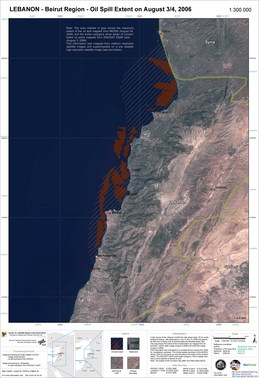
Lebanon Oilspill Overview
版权: ESA 2006; NASA 2006; DLR 2006; USGS 2000 Image processing, map created 05/08/2006 by DLR. Image processing and information extraction by Telespazio in the framework of GSE MARCOAST. Analysis and map creation by DLR in the frame of GSE RISK-EOS.
150m (ASAR); 250m (MODIS); 30m (Landsat) resolution
Information about the Product
已获得: 03/08/2006, 04/08/2006; 21/07/2000
源:
Envisat ASAR and Terra/Aqua MODIS; Landsat 7 ETM
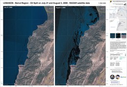
Lebanon Oilspill Radar Imagery
版权: ESA 2006; USGS 2000 Image processing, map created 05/08/2006 by DLR. Image processing and information extraction by Telespazio in the framework of GSE MARCOAST. Analysis and map creation by DLR in the frame of GSE RISK-EOS.
150m (ASAR); 30m (Landsat) resolution
Information about the Product
已获得: 21/07/2006, 03/08/2006; 21/07/2000
源:
Envisat ASAR and Landsat 7 ETM
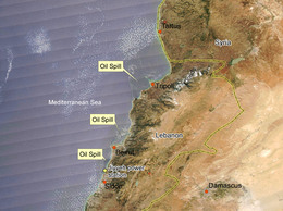
Lebanon Oilspill Annotated MODIS Time Series 04/08/2006
版权:
NASA (MODIS Rapid Response System) Image processing, map created 05/08/2006 by DLR. Image processing and information extraction by Telespazio in the framework of GSE MARCOAST. Analysis and map creation by DLR in the frame of GSE RISK-EOS.
250m resolution
Information about the Product
已获得: 08/04/2006
源:
Terra/Aqua MODIS
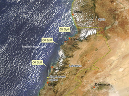
Lebanon Oilspill Annotated MODIS Time Series 01/08/2006
版权:
NASA (MODIS Rapid Response System) Image processing, map created 05/08/2006 by DLR. Image processing and information extraction by Telespazio in the framework of GSE MARCOAST. Analysis and map creation by DLR in the frame of GSE RISK-EOS.
250m resolution
Information about the Product
已获得: 08/01/2006
源:
Terra/Aqua MODIS
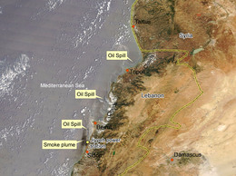
Lebanon Oilspill Annotated MODIS Time Series 23/07/2006
版权:
NASA (MODIS Rapid Response System) Image processing, map created 05/08/2006 by DLR. Image processing and information extraction by Telespazio in the framework of GSE MARCOAST. Analysis and map creation by DLR in the frame of GSE RISK-EOS.
250m resolution
Information about the Product
已获得: 07/23/2006
源:
Terra/Aqua MODIS
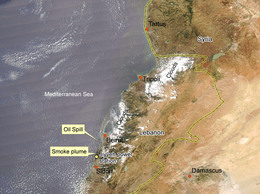
Lebanon Oilspill Annotated MODIS Time Series 19/07/2006
版权:
NASA (MODIS Rapid Response System) Image processing, map created 05/08/2006 by DLR. Image processing and information extraction by Telespazio in the framework of GSE MARCOAST. Analysis and map creation by DLR in the frame of GSE RISK-EOS.
250m resolution
Information about the Product
已获得: 07/19/2006
源:
Terra/Aqua MODIS
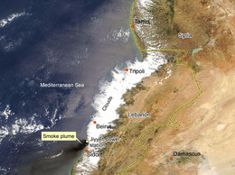
Lebanon Oilspill Annotated MODIS Time Series 16/07/2006
版权:
NASA (MODIS Rapid Response System) Image processing, map created 05/08/2006 by DLR. Image processing and information extraction by Telespazio in the framework of GSE MARCOAST. Analysis and map creation by DLR in the frame of GSE RISK-EOS.
250m resolution
Information about the Product
已获得: 07/16/2006
源:
Terra/Aqua MODIS

Lebanon Oilspill Overview
版权:
ESA 2006; NASA 2006; DLR 2006 Image processing, map created 05/08/2006 by DLR. Image processing and information extraction by Telespazio in the framework of GSE MARCOAST. Analysis and map creation by DLR in the frame of GSE RISK-EOS.
250m (MODIS); 30m (Landsat) resolution
Information about the Product
已获得: 01/08/2006; 21/07/2000
源:
Terra/Aqua MODIS; Landsat 7 ETM
 返回完整的响应档案

 English
 Spanish
 French
 Chinese
 Russian
 Portuguese


