最小化 最新宪章启动

Charter activations

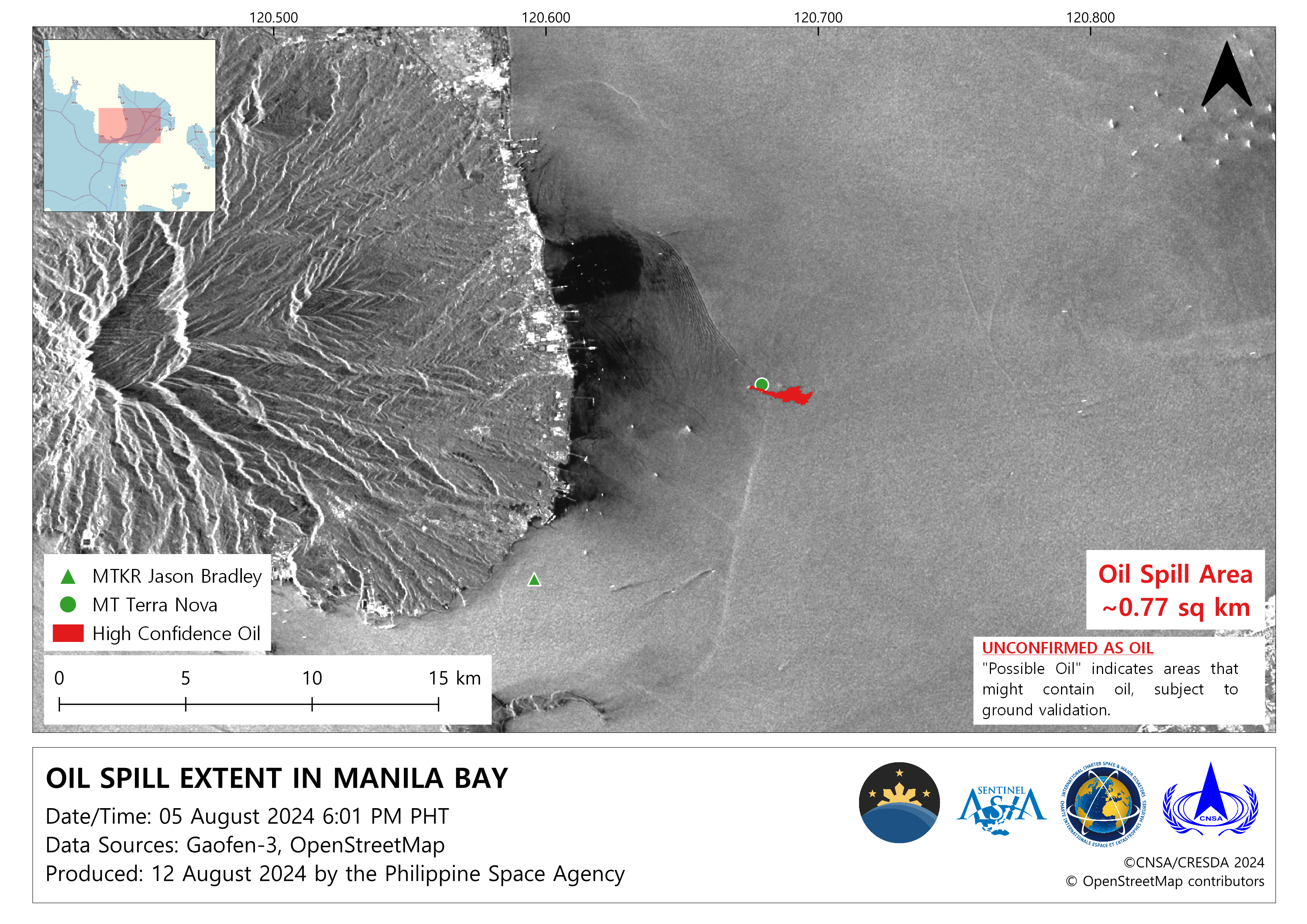
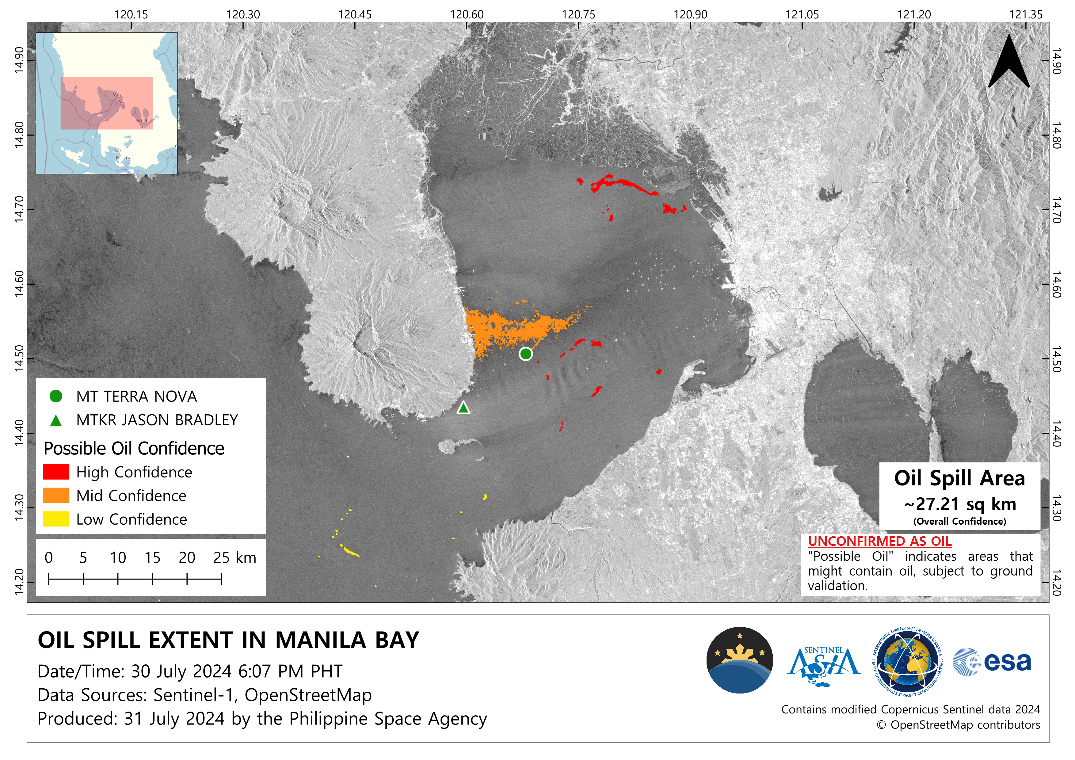
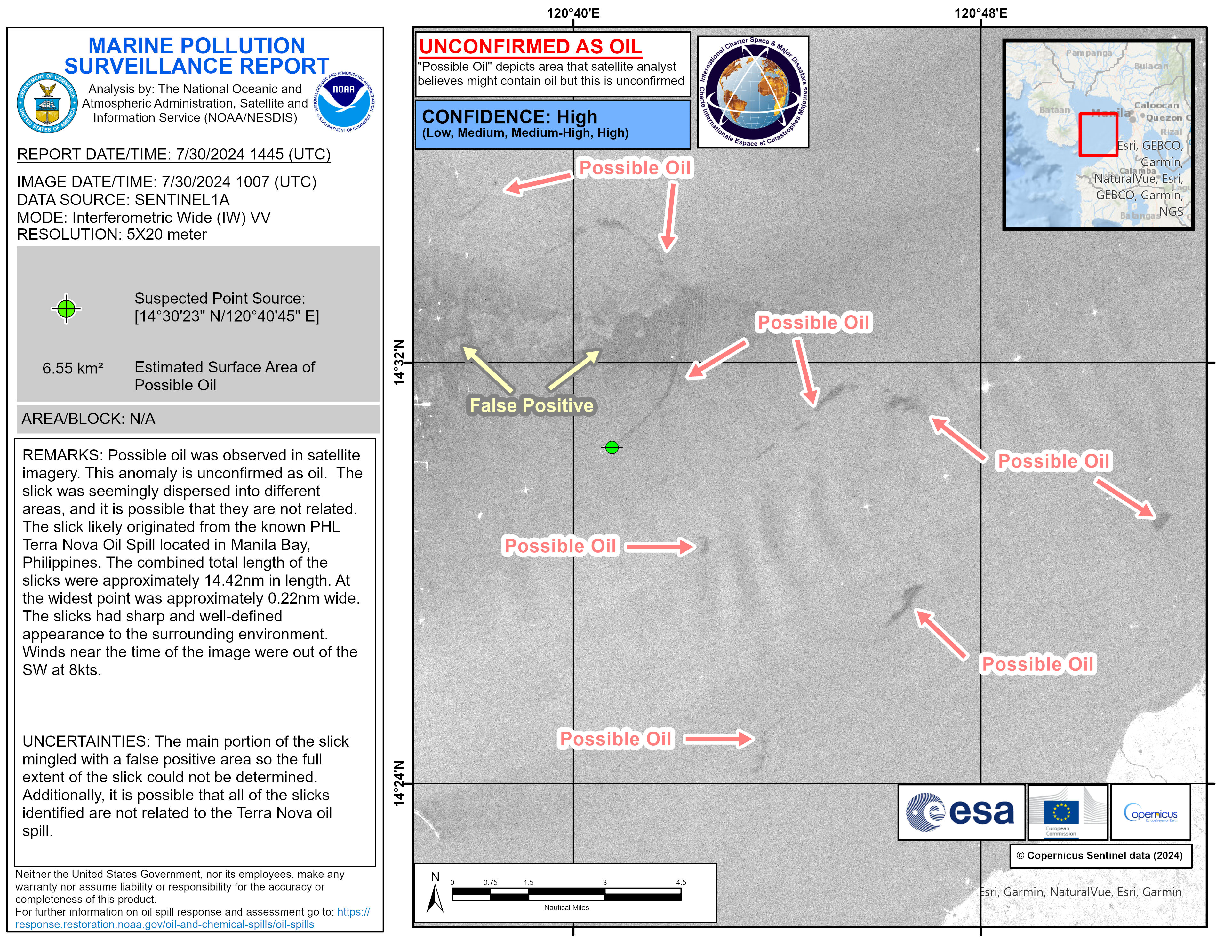
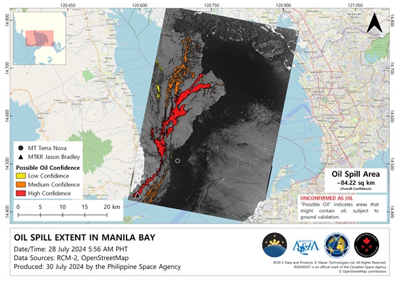
Oil spill in Philippines

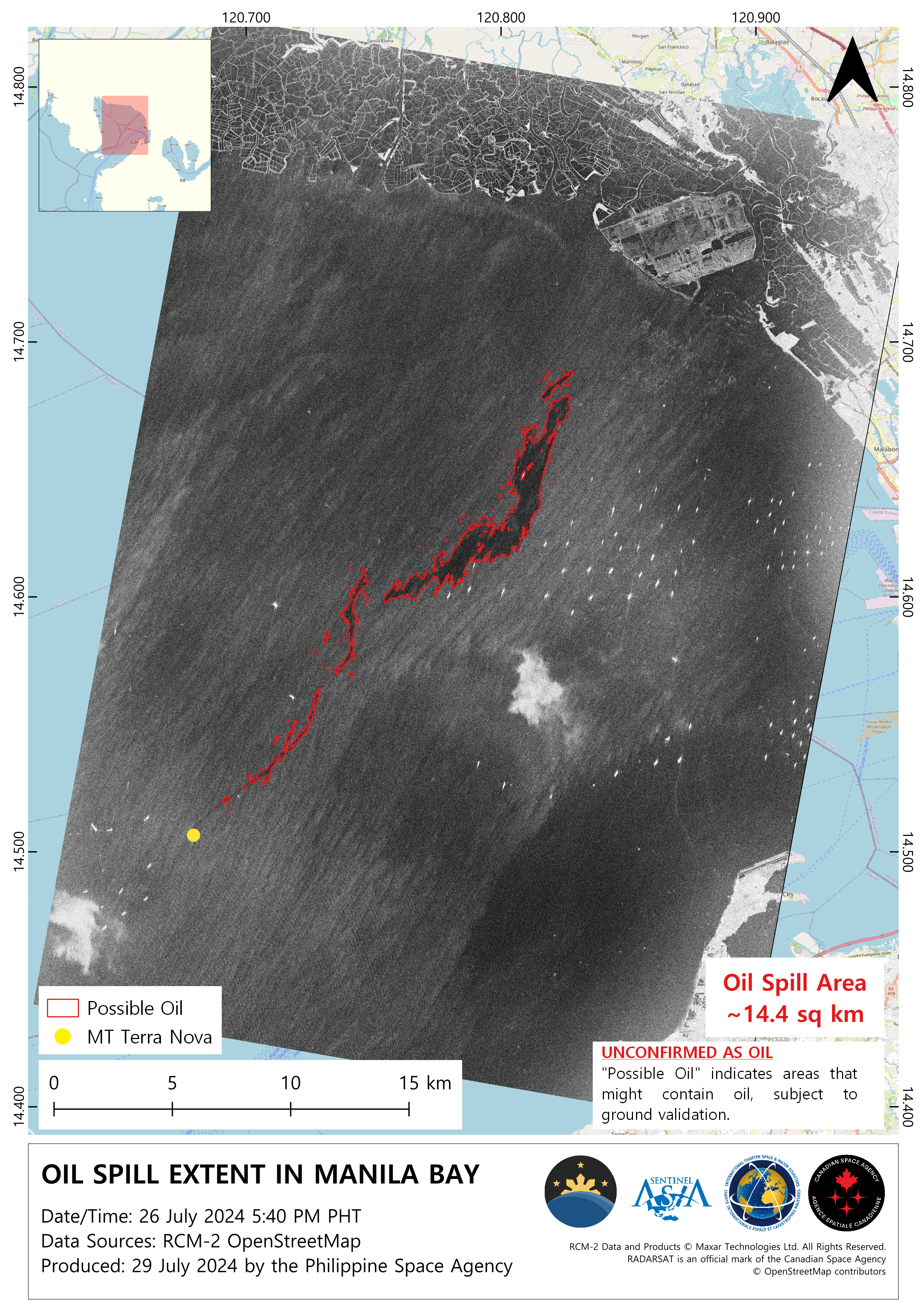
A Philippine-flagged vessel the MT Terra Nova carrying 1.4 million litres of industrial fuel sank in rough seas off the Bataan province in the Philippines on 25 July, causing the death of a crew member.

Resources cannot be dispatched because of strong winds and high waves but an aerial survey by the coast guard has shown an oil slick spreading roughly two nautical miles and being driven by strong waves.

Officials are concerned, the waters where the ship sank are close to Manila and there is real danger the spill could reach the capital.

In 2023, oil tanker Princess Empress was carrying about 800,000 litres of industrial fuel when it capsized on 28 February and eventually sank, causing an oil spill that took three months to clean up.

事件类型:Oil spill
事件地点:Philippines
启动宪章的日期:2024-07-25
宪章启动时间:18:39
宪章启动时区:UTC+09:00
宪章要求者:ADRC on behalf of PhilSA
启动ID:897
项目经理:Julius Judan (PhilSA-SMCOD (Space Mission Control and Operations Division))
act-value-adders:PhilSA
Copernicus EMS
UNITAR
Marion Sutton (CLS)
Activation handled in collaboration with Copernicus Emergency Management Service

Products

Oil Spill Extent in Manila Bay

版权: ©CNSA/CRESDA (2024)
Map produced by Philippine Space Agency

Information about the Product

已获得: 05/08/2024

源: GF-3

类别: Delineation Monitoring Maps

Oil Spill Extent in Manila Bay, the Phillipines

版权: Contains modified Copernicus Sentinel data (2024)
Map produced by the Philippine Space Agency

Information about the Product

已获得: 30/07/2024

源: Sentinel-1

类别: Delineation Monitoring Maps

Pollution report of the oil spill in Manilla Bay

版权: Contains modified Copernicus Sentinel data (2024)
Map produced by NOAA

Information about the Product

已获得: 30/07/2024

源: Sentinel-1

类别: Reference Map

Oil Spill Extent in Manila Bay

版权: RADARSAT Constellation Mission Imagery © Government of Canada (2024) - RADARSAT is an official mark of the Canadian Space Agency
Map produced by the Philippine Space Agency

Information about the Product

已获得: 27/07/2024

源: RCM

类别: Delineation Monitoring Maps

Oil Spill Extent in Manila Bay

版权: RADARSAT Constellation Mission Imagery © Government of Canada (2024) - RADARSAT is an official mark of the Canadian Space Agency
Map produced by the Philippine Space Agency

Information about the Product

已获得: 27/07/2024

源: RCM

类别: Delineation Monitoring Maps

Oil Spill Extent in Manila Bay

版权: RADARSAT Constellation Mission Imagery © Government of Canada (2024) - RADARSAT is an official mark of the Canadian Space Agency
Map produced by the Philippine Space Agency

Information about the Product

已获得: 26/07/2024

源: RCM

类别: Delineation Monitoring Maps

Oil Spill Extent in Manila Bay

版权: © DLR e.V. (2024), Distribution Airbus DS Geo GmbH
Map produced by the Philippine Space Agency

Information about the Product

已获得: 27/07/2024

源: TanDEM-X

类别: Delineation Monitoring Maps

Potential location of oil spill in Manila Bay, the Philippines
Download full product

版权: PAZ satellite image © Hisdesat Servicios Estratégicos S.A., 2021 (acquired on 26/07/2024 at 09:57 UTC, resolution 6.02 m). All images are provided under COPERNICUS by the European Union and ESA, all rights reserved.
Map produced by Copernicus EMS

Information about the Product

已获得: 26/07/2024

源: Sentinel-2

类别: Delineation Monitoring Maps

Terra Nova Oil Spill in Manila Bay, the Philippines

版权: RADARSAT Constellation Mission Imagery © Government of Canada (2024) - RADARSAT is an official mark of the Canadian Space Agency
Map produced by NOAA

Information about the Product

已获得: 27/07/2024

源: RCM

类别: Delineation Map

Terra Nova Oil Spill, Manila Bay, the Philippines

版权: © DLR e.V. (2024), Distribution Airbus DS Geo GmbH
Map produced by NOAA

Information about the Product

已获得: 27/07/2024

源: TanDEM-X

类别: Delineation Map

Oil Spill in Manila Bay, the Philippines
Download full product

版权: © DLR e.V. (2024), Distribution Airbus DS Geo GmbH
Map produced by Copernicus EMS

Information about the Product

已获得: 27/07/2024

源: TanDEM-X

类别: Delineation Monitoring Maps

Terra Nova Oil Spill, Manila Bay, the Philippines

版权: RADARSAT Constellation Mission Imagery © Government of Canada (2024) - RADARSAT is an official mark of the Canadian Space Agency
Map produced by NOAA

Information about the Product

已获得: 26/07/2024

源: RCM

类别: Delineation Map

Potential location of oil spill in Manila Bay, the Philippines
Download full product

版权: RADARSAT Constellation Mission Imagery © Government of Canada (2024) - RADARSAT is an official mark of the Canadian Space Agency
Map produced by Copernicus EMS

Information about the Product

已获得: 25/07/2024

源: RCM

类别: Delineation Map

Oil Spill Extent in Manila Bay

版权: RADARSAT Constellation Mission Imagery © Government of Canada (2024) - RADARSAT is an official mark of the Canadian Space Agency
Map produced by the Philippine Space Agency

Information about the Product

已获得: 25/07/2024

源: RCM

类别: Delineation Map

返回完整的响应档案