 English
 Spanish
 French
 Chinese
 Russian
 Portuguese
 最新宪章启动
Charter activations
Oil spill in Mauritius
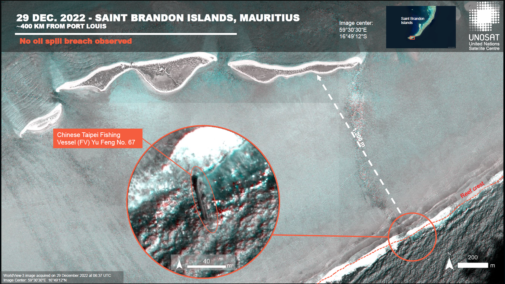
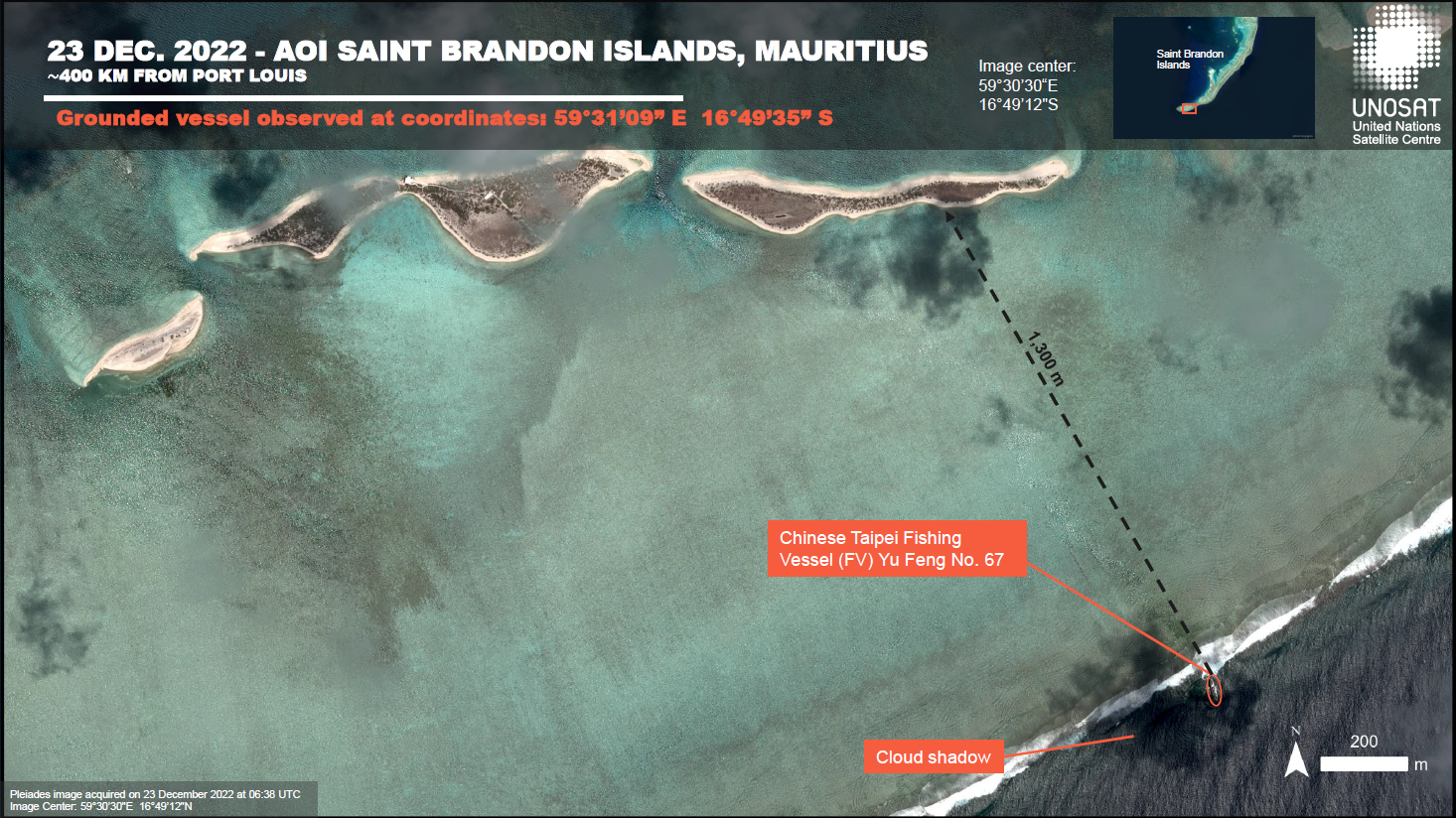
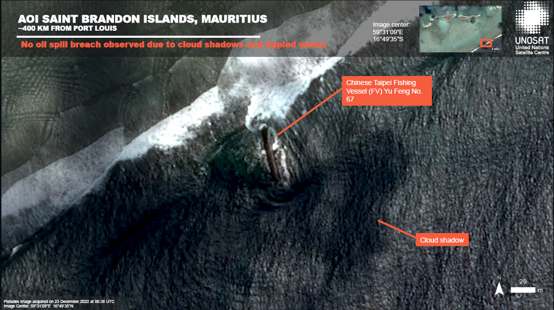
The Taiwanese Fishing Vessel Yu Feng Number 67 was grounded on a reef off the coast of Ile du Sud, St. Brandon archipelago, in Mauritius on 5 December 2022.
The crew of 20 were retrieved safely, but authorities were unable to remove the stricken vessel since the incident due to poor weather, which also prevented underwater inspections of the vessel to determine its condition. Some time after the vessel became grounded, the Yu Feng started to list to the side, but did not sink.
It was reported that at the time of the crash, the vessel was carrying approximately 63,000 kg of marine diesel fuel, 453 kg of lubricating oil and 60,000 kg of fishing bait. The crew had managed to throw some of the bait overboard after the crash but some remained onboard.
As of Saturday 7th January 2023, no evidence of oil spillage was found around the YU Feng 67 in St Brandon, authorities took water samples which showed no trace of heavy oil.
| 事件类型: | Oil spill |
| 事件地点: | Mauritius |
| 启动宪章的日期: | 2022-12-20 |
| 宪章启动时间: | 12:13 |
| 宪章启动时区: | UTC+01:00 |
| 宪章要求者: | UNITAR on behalf of United Nations Environment Programme |
| 启动ID: | 793 |
| 项目经理: | Teodoro Hunger (UNITAR/UNOSAT) |
Products
Preliminary satellite-derived assessment - Oil spill threat. Saint Brandon Islands, Mauritius - 30 December 2022
Download full report
版权: TerraSAR-X © DLR e.V. (2022), Distribution Airbus DS Geo GmbH
WorldView-3 © (2022) DigitalGlobe, Inc., Longmont CO USA 80503. DigitalGlobe and the DigitalGlobe logos are trademarks of DigitalGlobe, Inc. The use and/or dissemination of this data and/or of any product in any way derived there from are restricted. Unauthorized use and/or dissemination is prohibited.
KOMPSAT-5 © KARI (2022).
Includes Pleiades material © CNES (2022), Distribution Airbus DS.
RADARSAT-2 Data and Products © Maxar Technologies Ltd. (2022). All Rights Reserved. RADARSAT is an official mark of the Canadian Space Agency.
Report produced by UNITAR / UNOSAT
Information about the Product
已获得: KOMPSAT-5: 21/12/2022
Pleiades: 23/12/2022
RADARSAT-2: 24/12/2022
TerraSAR-X: 29/12/2022
WorldView-3: 29/12/2022
源: TerraSAR-X / WorldView-3 / KOMPSAT-5 / Pleiades / RADARSAT-2
类别: Delineation Map
Preliminary satellite-derived assessment - Oil spill threat. Saint Brandon Islands, Mauritius - 27 December 2022
Download full report
版权: Includes Pleiades material © CNES (2022), Distribution Airbus DS.
KOMPSAT-5 © KARI (2022)
RADARSAT-2 Data and Products © Maxar Technologies Ltd. (2022). All Rights Reserved. RADARSAT is an official mark of the Canadian Space Agency.
Report produced by UNITAR / UNOSAT
Information about the Product
已获得: Pleiades: 23/12/2022
KOMPSAT-5: 21/12/2022
RADARSAT-2: 24/12/2022
源: Pleiades / KOMPSAT-5 / RADARSAT-2
类别: Delineation Map
Preliminary satellite-derived assessment - Oil spill threat. Saint Brandon Islands, Mauritius
Download full report
版权: Includes Pleiades material © CNES (2022), Distribution Airbus DS.
Report prepared by UNITAR / UNOSAT
Information about the Product
已获得: 23/12/2022
源: Pleiades
类别: Delineation Map
 返回完整的响应档案

