Charter activations
Landslide and flooding in South Africa
Torrential downpours and flooding have triggered mudslides on eastern coast of South Africa.
The death toll from floods and mudslides after rainstorms struck the South African port city of Durban and surrounding areas in KwaZulu-Natal province climbed to 308.
National Defense Force were called in to assist emergency rescue teams struggling to reach the affected areas in the KwaZulu-Natal province.
Related News and Resources
| 事件类型: | Floods, landslides |
| 事件地点: | South Africa |
| 启动宪章的日期: | 2022-04-13 |
| 宪章启动时间: | 13:35 |
| 宪章启动时区: | UTC+02:00 |
| 宪章要求者: | National Disaster Management Centre |
| 启动ID: | 755 |
| 项目经理: | SANSA |
Products
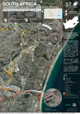
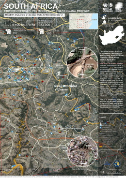
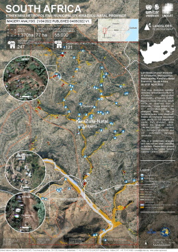
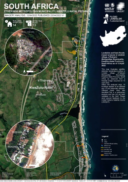
Landslide impact analysis in eThekwini, Metropolitan Municipality, KwaZulu-Natal Province, South Africa
版权: © (2022) DigitalGlobe, Inc., Longmont CO USA 80503. DigitalGlobe and the DigitalGlobe logos are trademarks of DigitalGlobe, Inc. The use and/or dissemination of this data and/or of any product in any way derived there from are restricted. Unauthorized use and/or dissemination is prohibited.
Map produced by UNITAR / UNOSAT
Information about the Product
已获得: 20/04/2022
源: WorldView-3
类别: Grading Map
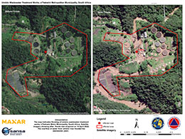
Umbilo Wastewater Treatment Works flooded. eThekwini Metropolitan Municipality, South Africa
版权: © (2022) DigitalGlobe, Inc., Longmont CO USA 80503. DigitalGlobe and the DigitalGlobe logos are trademarks of DigitalGlobe, Inc. The use and/or dissemination of this data and/or of any product in any way derived there from are restricted. Unauthorized use and/or dissemination is prohibited.
Map produced by National Disaster Management Centre of South Africa
Information about the Product
已获得: 14/04/2022
源: WorldView-2
类别: Delineation Map
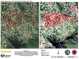
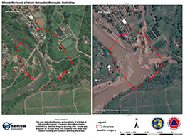
Houses and school affected by flooding and mudslide. Molweni, Ngqungqulu, eThekwini Metropolitan Municipality, South Africa.
版权: © 2004 GeoEye NextView License
Map produced by National Disaster Management Centre of South Africa
Information about the Product
已获得: 15/04/2022
源: GeoEye-1
类别: Delineation Map
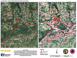
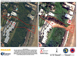
Mudslide affected multiple households and school. Lower Molweni, eThekwini Metropolitan Municipality, South Africa
版权: © (2022) DigitalGlobe, Inc., Longmont CO USA 80503. DigitalGlobe and the DigitalGlobe logos are trademarks of DigitalGlobe, Inc. The use and/or dissemination of this data and/or of any product in any way derived there from are restricted. Unauthorized use and/or dissemination is prohibited.
Map produced by National Disaster Management Centre of South Africa
Information about the Product
已获得: 14/04/2022
源: WorldView-2
类别: Delineation Map
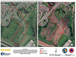
Himalaya Road and Travancore Driver interchange inundated in flooding water. eThekwini Metropolitan Municipality, South Africa
版权: © (2022) DigitalGlobe, Inc., Longmont CO USA 80503. DigitalGlobe and the DigitalGlobe logos are trademarks of DigitalGlobe, Inc. The use and/or dissemination of this data and/or of any product in any way derived there from are restricted. Unauthorized use and/or dissemination is prohibited.
Map produced by National Disaster Management Centre of South Africa
Information about the Product
已获得: 15/04/2022
源: WorldView-3
类别: Delineation Map
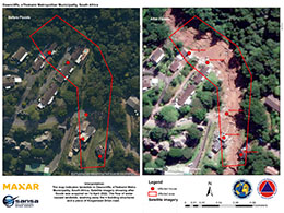
Houses washed away. Dawncliffe, eThekwini Metropolitan Municipality, South Africa
版权: © (2022) DigitalGlobe, Inc., Longmont CO USA 80503. DigitalGlobe and the DigitalGlobe logos are trademarks of DigitalGlobe, Inc. The use and/or dissemination of this data and/or of any product in any way derived there from are restricted. Unauthorized use and/or dissemination is prohibited.
Map produced by National Disaster Management Centre of South Africa
Information about the Product
已获得: WorldView-1: 14/04/2022
WorldView-2: 18/04/2022
WorldView-3: 14/04/2022
源: WorldView-1 / WorldView-2 / WorldView-3
类别: Delineation Map
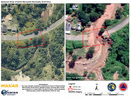
Road washed away. Bambanani Street, eThekwini Metropolitan Municipality, South Africa
版权: © (2022) DigitalGlobe, Inc., Longmont CO USA 80503. DigitalGlobe and the DigitalGlobe logos are trademarks of DigitalGlobe, Inc. The use and/or dissemination of this data and/or of any product in any way derived there from are restricted. Unauthorized use and/or dissemination is prohibited.
Map produced by National Disaster Management Centre of South Africa
Information about the Product
已获得: 15/04/2022
源: WorldView-2
类别: Delineation Map
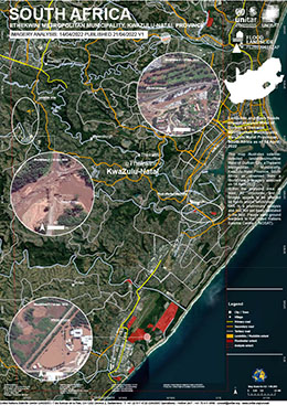
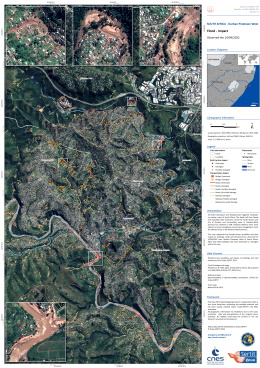
Landslide and flash floods impact analysis West of Durban, eThekwini Metropolitan Municipality, KwaZulu-Natal Province, South Africa
版权: © (2022) DigitalGlobe, Inc., Longmont CO USA 80503. DigitalGlobe and the DigitalGlobe logos are trademarks of DigitalGlobe, Inc. The use and/or dissemination of this data and/or of any product in any way derived there from are restricted. Unauthorized use and/or dissemination is prohibited.
Map produced by UNITAR/UNOSAT
Information about the Product
已获得: 14/04/2022
源: WorldView-3
类别: Delineation Map
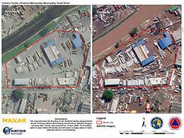
Unitrans Facility, eThekwini Metropolitan Municipality, South Africa
版权: © (2022) DigitalGlobe, Inc., Longmont CO USA 80503. DigitalGlobe and the DigitalGlobe logos are trademarks of DigitalGlobe, Inc. The use and/or dissemination of this data and/or of any product in any way derived there from are restricted. Unauthorized use and/or dissemination is prohibited.
Map produced by National Disaster Management Centre of South Africa
Information about the Product
已获得: WorldView-1: 14/04/2022
WorldView-2: 18/04/2022
WorldView-3: 14/04/2022
源: WorldView-1 / WorldView-2 / WorldView-3
类别: Delineation Map
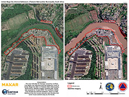
Umlazi mega city informal settlement, eThekwini Metropolitan Municipality, South Africa
版权: © (2022) DigitalGlobe, Inc., Longmont CO USA 80503. DigitalGlobe and the DigitalGlobe logos are trademarks of DigitalGlobe, Inc. The use and/or dissemination of this data and/or of any product in any way derived there from are restricted. Unauthorized use and/or dissemination is prohibited.
Map produced by National Disaster Management Centre of South Africa
Information about the Product
已获得: WorldView-1: 14/04/2022
WorldView-3: 14/04/2022
源: WorldView-1 / WorldView-3
类别: Delineation Map
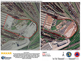
Transnet Engineering, Edwin Swales Drive, eThekwini Metro Municipality, South Africa
版权: © (2022) DigitalGlobe, Inc., Longmont CO USA 80503. DigitalGlobe and the DigitalGlobe logos are trademarks of DigitalGlobe, Inc. The use and/or dissemination of this data and/or of any product in any way derived there from are restricted. Unauthorized use and/or dissemination is prohibited.
Map produced by National Disaster Management Centre of South Africa
Information about the Product
已获得: WorldView-1: 14/04/2022
WorldView-2: 18/04/2022
WorldView-3: 14/04/2022
源: WorldView-1 / WorldView-2 / WorldView-3
类别: Delineation Map
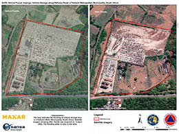
SAPS Vehicle Pound, Isipingo, Refinery Road, eThekwini, South Africa
版权: © (2022) DigitalGlobe, Inc., Longmont CO USA 80503. DigitalGlobe and the DigitalGlobe logos are trademarks of DigitalGlobe, Inc. The use and/or dissemination of this data and/or of any product in any way derived there from are restricted. Unauthorized use and/or dissemination is prohibited.
Map produced by National Disaster Management Centre of South Africa
Information about the Product
已获得: WorldView-1: 14/04/2022
WorldView-3: 14/04/2022
源: WorldView-1 / WorldView-3
类别: Delineation Map
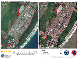
SAPREF Refinery, eThekwini Metro Municipality, South Africa
版权: © (2022) DigitalGlobe, Inc., Longmont CO USA 80503. DigitalGlobe and the DigitalGlobe logos are trademarks of DigitalGlobe, Inc. The use and/or dissemination of this data and/or of any product in any way derived there from are restricted. Unauthorized use and/or dissemination is prohibited.
Map produced by National Disaster Management Centre of South Africa
Information about the Product
已获得: WorldView-1: 14/04/2022
WorldView-3: 14/04/2022
源: WorldView-1 / WorldView-3
类别: Delineation Map
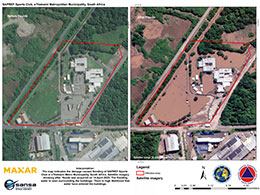
Flooding at SAPREF sports club in eThekwini Metro Municipality, South Africa
版权: © (2022) DigitalGlobe, Inc., Longmont CO USA 80503. DigitalGlobe and the DigitalGlobe logos are trademarks of DigitalGlobe, Inc. The use and/or dissemination of this data and/or of any product in any way derived there from are restricted. Unauthorized use and/or dissemination is prohibited.
Map produced by National Disaster Management Centre of South Africa
Information about the Product
已获得: WorldView-1: 14/04/2022
WorldView-3: 14/04/2022
源: WorldView-1 / WorldView-3
类别: Delineation Map
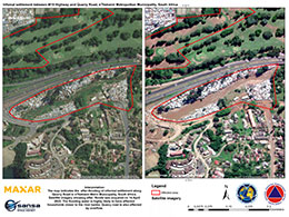
Flooding at settlement on Quarry Road in eThekwini Metro Municipality, South Africa
版权: © (2022) DigitalGlobe, Inc., Longmont CO USA 80503. DigitalGlobe and the DigitalGlobe logos are trademarks of DigitalGlobe, Inc. The use and/or dissemination of this data and/or of any product in any way derived there from are restricted. Unauthorized use and/or dissemination is prohibited.
Map produced by National Disaster Management Centre of South Africa
Information about the Product
已获得: WorldView-1: 14/04/2022
WorldView-3: 14/04/2022
源: WorldView-1 / WorldView-3
类别: Reference Map
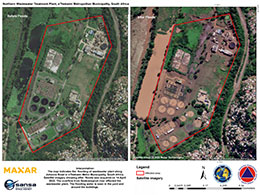
Flooding at northern wastewater treatment plant in eThekwini Metro Municipality, South Africa
版权: © (2022) DigitalGlobe, Inc., Longmont CO USA 80503. DigitalGlobe and the DigitalGlobe logos are trademarks of DigitalGlobe, Inc. The use and/or dissemination of this data and/or of any product in any way derived there from are restricted. Unauthorized use and/or dissemination is prohibited.
Map produced by National Disaster Management Centre of South Africa
Information about the Product
已获得: WorldView-1: 14/04/2022
WorldView-3: 14/04/2022
源: WorldView-1 / WorldView-3
类别: Delineation Map
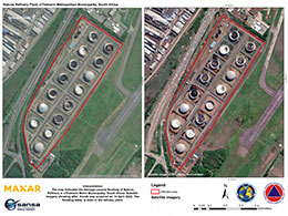
Flooding at Nactos Refinery in eThekwini Metro Municipality, South Africa
版权: © (2022) DigitalGlobe, Inc., Longmont CO USA 80503. DigitalGlobe and the DigitalGlobe logos are trademarks of DigitalGlobe, Inc. The use and/or dissemination of this data and/or of any product in any way derived there from are restricted. Unauthorized use and/or dissemination is prohibited
Map produced by National Disaster Management Centre of South Africa
Information about the Product
已获得: WorldView-1: 14/04/2022
WorldView-3: 14/04/2022
源: WorldView-1 / WorldView-3
类别: Delineation Map
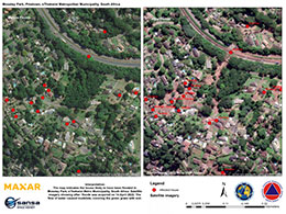
Area affected by flooding and mudslide at Mosely Park in South Africa
版权: © (2022) DigitalGlobe, Inc., Longmont CO USA 80503. DigitalGlobe and the DigitalGlobe logos are trademarks of DigitalGlobe, Inc. The use and/or dissemination of this data and/or of any product in any way derived there from are restricted. Unauthorized use and/or dissemination is prohibited.
Map produced by National Disaster Management Centre of South Africa
Information about the Product
已获得: WorldView-1: 14/04/2022
WorldView-2: 18/04/2022
WorldView-3: 14/04/2022
源: WorldView-1 / WorldView-2 / WorldView-3
类别: Delineation Map
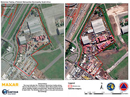
Area inundated by water at Momentus Trading, in eThekwini Metro Municipality, South Africa
版权: © (2022) DigitalGlobe, Inc., Longmont CO USA 80503. DigitalGlobe and the DigitalGlobe logos are trademarks of DigitalGlobe, Inc. The use and/or dissemination of this data and/or of any product in any way derived there from are restricted. Unauthorized use and/or dissemination is prohibited.
Map produced by National Disaster Management Centre of South Africa
Information about the Product
已获得: WorldView-1: 14/04/2022
WorldView-2: 18/04/2022
WorldView-3: 14/04/2022
源: WorldView-1 / WorldView-2 / WorldView-3
类别: Delineation Map
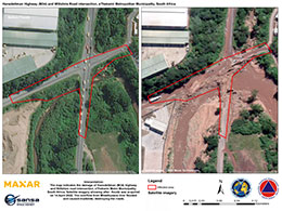
Area affected by water overflow from Mhlathuzana River at Hansdettman Highway in South Africa
版权: © (2022) DigitalGlobe, Inc., Longmont CO USA 80503. DigitalGlobe and the DigitalGlobe logos are trademarks of DigitalGlobe, Inc. The use and/or dissemination of this data and/or of any product in any way derived there from are restricted. Unauthorized use and/or dissemination is prohibited.
Map produced by National Disaster Management Centre of South Africa
Information about the Product
已获得: WorldView-1: 14/04/2022
WorldView-2: 18/04/2022
WorldView-3: 14/04/2022
源: WorldView-1 / WorldView-2 / WorldView-3
类别: Delineation Map
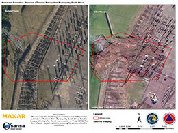
Mudslides at Klaarwater substation, Pinetown, in South Africa
版权: © (2022) DigitalGlobe, Inc., Longmont CO USA 80503. DigitalGlobe and the DigitalGlobe logos are trademarks of DigitalGlobe, Inc. The use and/or dissemination of this data and/or of any product in any way derived there from are restricted. Unauthorized use and/or dissemination is prohibited.
Map produced by National Disaster Management Centre of South Africa
Information about the Product
已获得: WorldView-1: 14/04/2022
WorldView-2: 14/04/2022
WorldView-3: 14/04/2022
源: WorldView-1 / WorldView-2 / WorldView-3
类别: Delineation Map
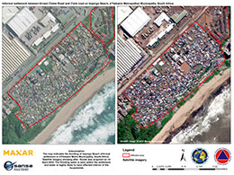
Area inundated with water at Isipingo Beach, South Africa
版权: © (2022) DigitalGlobe, Inc., Longmont CO USA 80503. DigitalGlobe and the DigitalGlobe logos are trademarks of DigitalGlobe, Inc. The use and/or dissemination of this data and/or of any product in any way derived there from are restricted. Unauthorized use and/or dissemination is prohibited.
Map produced by National Disaster Management Centre of South Africa
Information about the Product
已获得: WorldView-1: 14/04/2022
WorldView-3: 14/04/2022
源: WorldView-1 / WorldView-3
类别: Delineation Map
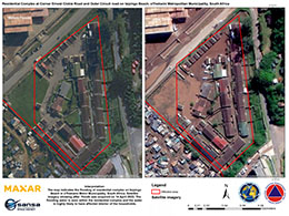
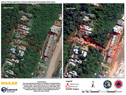
Flooding of residential complex on Isipingo Beach, eThekwini Metro Municipality, South Africa
版权: © (2022) DigitalGlobe, Inc., Longmont CO USA 80503. DigitalGlobe and the DigitalGlobe logos are trademarks of DigitalGlobe, Inc. The use and/or dissemination of this data and/or of any product in any way derived there from are restricted. Unauthorized use and/or dissemination is prohibited.
Map produced by National Disaster Management Centre of South Africa
Information about the Product
已获得: WorldView-1: 14/04/2022
WorldView-2: 14/04/2022
WorldView-3: 14/04/2022
源: WorldView-1 / WorldView-2 / WorldView-3
类别: Delineation Map
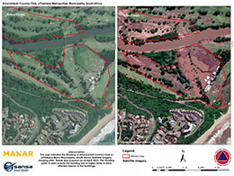
Area affected by flooding overflow from Mbokodweni river, at the Amanzimtoti country club in South Africa
版权: © (2022) DigitalGlobe, Inc., Longmont CO USA 80503. DigitalGlobe and the DigitalGlobe logos are trademarks of DigitalGlobe, Inc. The use and/or dissemination of this data and/or of any product in any way derived there from are restricted. Unauthorized use and/or dissemination is prohibited.
Map produced by National Disaster Management Centre of South Africa
Information about the Product
已获得: WorldView-1: 14/04/2022
WorldView-3: 14/04/2022
源: WorldView-1 / WorldView-3
类别: Delineation Map
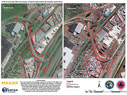
Area affected by water overflow from Mlazi river, South Africa
版权: © (2022) DigitalGlobe, Inc., Longmont CO USA 80503. DigitalGlobe and the DigitalGlobe logos are trademarks of DigitalGlobe, Inc. The use and/or dissemination of this data and/or of any product in any way derived there from are restricted. Unauthorized use and/or dissemination is prohibited.
Map produced by National Disaster Management Centre of South Africa
Information about the Product
已获得: WorldView-1: 14/04/2022
WorldView-3: 14/04/2022
源: WorldView-1 / WorldView-3
类别: Delineation Map
 返回完整的响应档案

 English
 Spanish
 French
 Chinese
 Russian
 Portuguese

