Charter activations
加拿大洪水
5月6日,由于温度升高导致暴雨和融雪,使加拿大蒙特利尔市受到特大洪水的袭击。为此,该市宣布进入紧急状态,在加拿大东部的魁北克省的126个城镇中,有1900所房屋被洪水淹没。地方当局已经证实,这项安全措施将持续约48小时。
此外,这场洪水不仅影响了蒙特利尔东部,而且在蒙特利尔西部也留有它的足迹。因此,里戈镇宣布进入紧急状态,市长发出了洪水区撤离命令。
除了魁北克,安大略省也受到暴雨引发的洪水的严重影响。在安大略省南部,加拿大新闻社已经证实,安大略湖的水位已达到1993年以来的程度。
| 事件类型: | 洪水 |
| 事件地点: | 加拿大 |
| 启动宪章的日期: | 2017年5月6日 |
| 宪章启动时间: | 14:59:00 |
| 宪章启动时区: | UTC-04:00 |
| 宪章要求者: | 加拿大公共安全部 |
| 启动ID: | 529 |
| 项目经理: | 加拿大太空局 |
Products

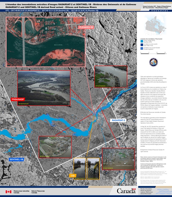
Flood extent on the Ottawa and Gatineau Rivers in Ottawa
版权: RADARSAT-2 Data and Products © MacDonald, Dettwiler and Associates Ltd. (2017) - All Rights Reserved. RADARSAT is an official trademark of the Canadian Space Agency.
Sentinel-1 © Copernicus Sentinel data (2017)
Pleiades © CNES (2017) - Distribution: Airbus Defence and Space, all rights reserved
Map produced by Natural Resources Canada
Information about the Product
已获得: RADARSAT-2: 09/05/2017
Sentinel-1B: 10/05/2017
Pleiades: 10/05/2017
源: RADARSAT-2 / Sentinel-1B / Pleiades

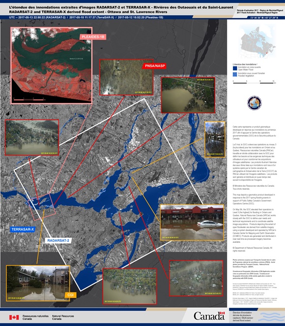
Flood extent on the Ottawa and St. Lawrence Rivers in Montreal
版权: RADARSAT-2 Data and Products © MacDonald, Dettwiler and Associates Ltd. (2017) - All Rights Reserved. RADARSAT is an official trademark of the Canadian Space Agency.
TerraSAR-X © DLR e. V. 2017, Distribution: Airbus DS Geo GmbH
Pleiades © CNES (2017) - Distribution: Airbus Defence and Space, all rights reserved
Map produced by Natural Resources Canada
Information about the Product
已获得: RADARSAT-2: 13/05/2017
TerraSAR-X: 10/05/2017
Pleiades: 12/05/2017
源: RADARSAT-2 / TerraSAR-X / Pleiades
 返回完整的响应档案

 English
 Spanish
 French
 Chinese
 Russian
 Portuguese


