 English
 Spanish
 French
 Chinese
 Russian
 Portuguese
 最新宪章启动
Charter activations
所罗门群岛地震与海啸
4月2日当地时间7时40分,所罗门群岛发生8.1级地震并伴有海啸。Giso岛受灾严重,但其他岛屿无法及时获得详细受灾情况。媒体目前报道称18人死亡,20人受伤。
| 事件类型: | 地震、海啸 |
| 事件地点: | 所罗门群岛 |
| 启动宪章的日期: | 2007年4月3日 |
| 宪章要求者: | UNOOSA |
| 项目经理: | Pacific Disaster Center |
Products
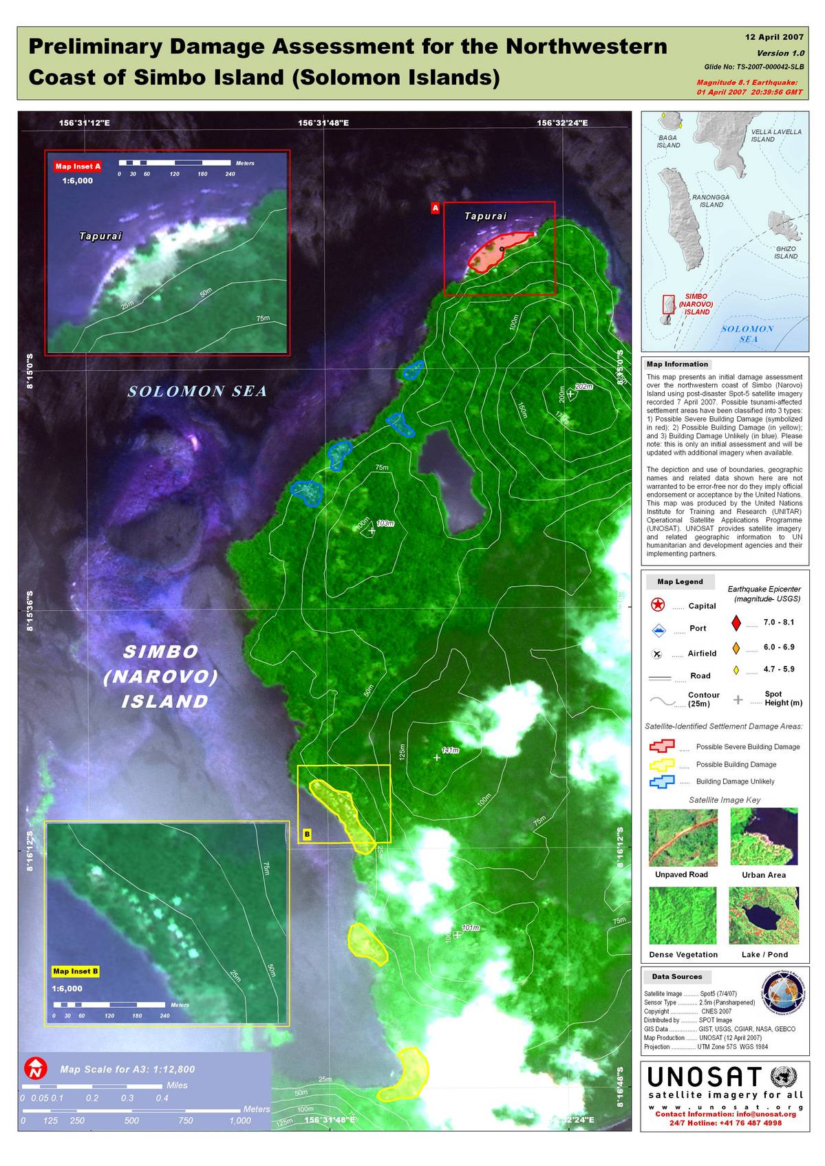
SPOT-5 image, Simbo Island Island, preliminary damage assessment
版权: CNES 2007; GIS Data: GIST, USGS, CGIAR, NASA, GEBCO
Image processing, map created 12/04/2007 by UNOSAT.
Information about the Product
已获得: 07/04/2007
Initial damage assessment, coast of Simbo Island. Possible tsunami-affected settlement areas have been classified into 3 types: 1) Possible Severe Building Damage (symbolized in red); 2) Possible Building Damage (in yellow); and 3) Building Damage Unlikely (in blue). Cloud cover has been symbolized to help highlight areas along the coast that have not been assessed for damage.
源: SPOT-5 (pan-sharpened), resolution 2.5m.
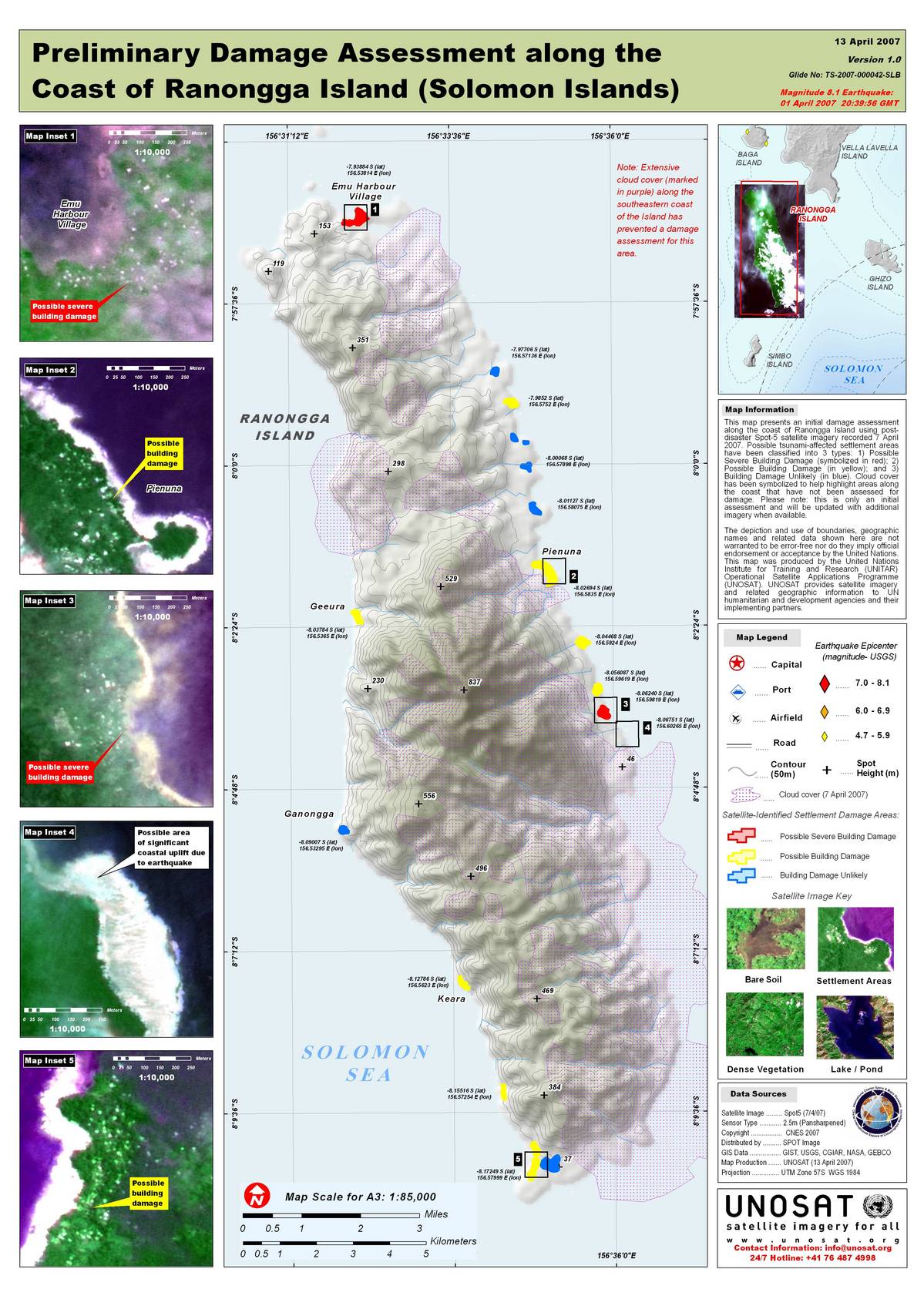
SPOT-5 image, Ranongga Island, preliminary damage assessment
版权: CNES 2007; GIS Data: GIST, USGS, CGIAR, NASA, GEBCO
Image processing, map created 13/04/2007 by UNOSAT.
Information about the Product
已获得: 07/04/2007
Initial damage assessment, coast of Ranongga Island. Possible tsunami-affected settlement areas have been classified into 3 types: 1) Possible Severe Building Damage (symbolized in red); 2) Possible Building Damage (in yellow); and 3) Building Damage Unlikely (in blue). Cloud cover has been symbolized to help highlight areas along the coast that have not been assessed for damage.
源: SPOT-5 (pan-sharpened), resolution 2.5m.
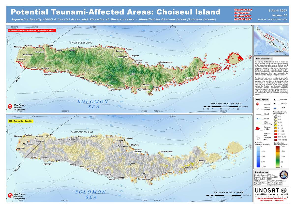
2004 Population Density, Coastal Areas, Choiseul Island
版权: Credits: GIS: GIST, NGA, USGS, GEBCO 2004-2007 Image processing, map created 03/04/2007 by UNOSAT.
Information about the Product
已获得: Top: areas 10 meters and less in elevation (marked in red) potentially affected by the tsunami along the coast of Choiseul Island. Bottom: estimated population density in people per square km. in 2004, Choiseul Island.
源: SRTM dataset; Landscan 2004 , resolution 90m (SRTM).
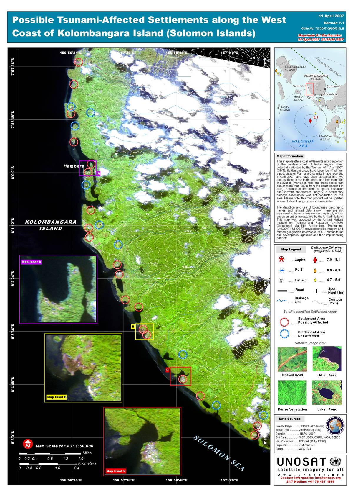
Formosat-2 image, Kolombangara Island
版权: NSPO 2007; GIS Data: GIST, USGS, CGIAR, NASA, GEBCO Image processing, map created 11/04/2007 by UNOSAT.
Information about the Product
已获得: 06/04/2007 Potentially affected local settlements along a portion of the western coast of Kolombangara Island. Settlement areas have been classified into two groups: those close to the coast and less than 10m in elevation (marked in red), and those above 10m and/or more than 250m from the coast (marked in blue). Because of limitations of spatial resolution and relevant pre-disaster imagery, a preliminary damage assessment was not conducted for this area.
源: Formosat-2 (pan-sharpened), resolution 2m.

Solomon Islands, Quickbird, Ghizo Island Damage
版权: Digital Globe 2007; GIS Data: PDC, GIST, USGS, CGIAR, NASA Image processing, map created 08/04/2007 by UNOSAT.
Information about the Product
已获得: 05/04/2007 Initial damage assessment, Ghizo Island using post-disaster QuickBird satellite imagery. 1) Building Damage (in red) for areas of likely damage to buildings and infrastructure; 2) Coastal Flooding (in yellow) for areas of identified as likely inundated and possibly eroded; and 3) Standing flood waters (in blue) for areas of visible water likely caused by the tsunami.
源: QuickBird (pan-sharpened), resolution 0.6m .
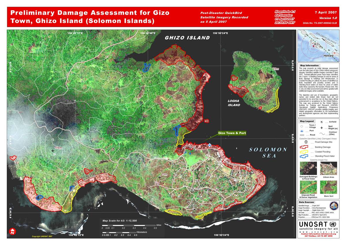
Solomon Islands, Quickbird, Gizo Town Damage
版权: Digital Globe 2007; GIS Data: PDC, GIST, USGS, CGIAR, NASA Image processing, map created 07/04/2007 by UNOSAT.
Information about the Product
已获得: 05/04/2007 Initial damage assessment, main town of Gizo (Ghizo Island) using post-disaster QuickBird satellite imagery. Tsunami-affected areas have been classified into 3 types: 1) Building Damage (in red) for areas of likely damage to buildings and infrastructure; 2) Coastal Flooding (in yellow) for areas of identified as likely inundated and possibly eroded; and 3) Standing flood waters (in blue) for areas of visible water likely caused by the tsunami.
源: QuickBird (pan-sharpened), resolution 0.6m .
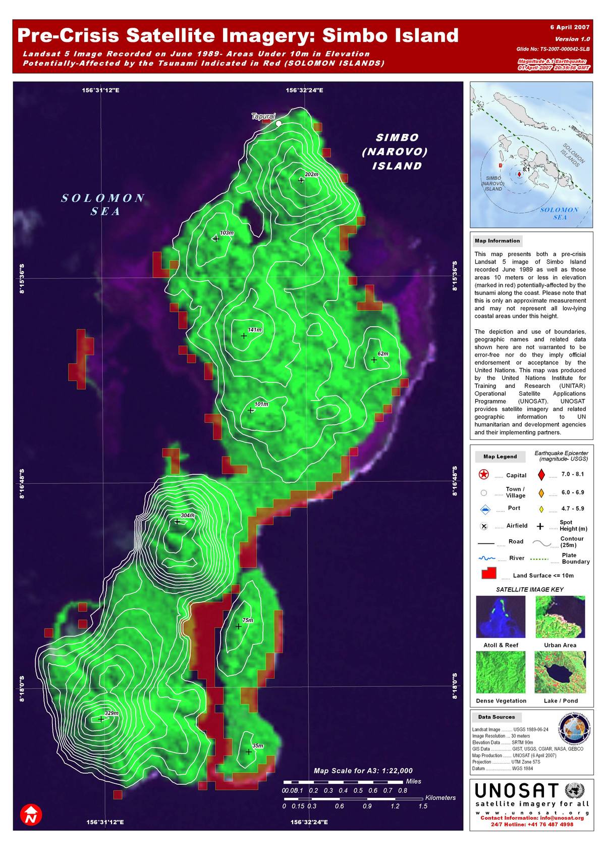
Pre-Crisis imagery, Simbo Island Island
版权: Credit: USGS 1989; GIS Data: GIST, USGS, CGIAR, NASA, GEBCO Image processing, map created 06/04/2007 by UNOSAT.
Information about the Product
已获得: 06/24/1989 Pre-crisis Landsat 7 image of Simbo Island as well as coastal areas 10 meters or less in elevation (marked in red) potentially affected by the tsunami (approximation; may not represent all low-lying coastal areas under this height).
源: Landsat-5, resolution 30m .
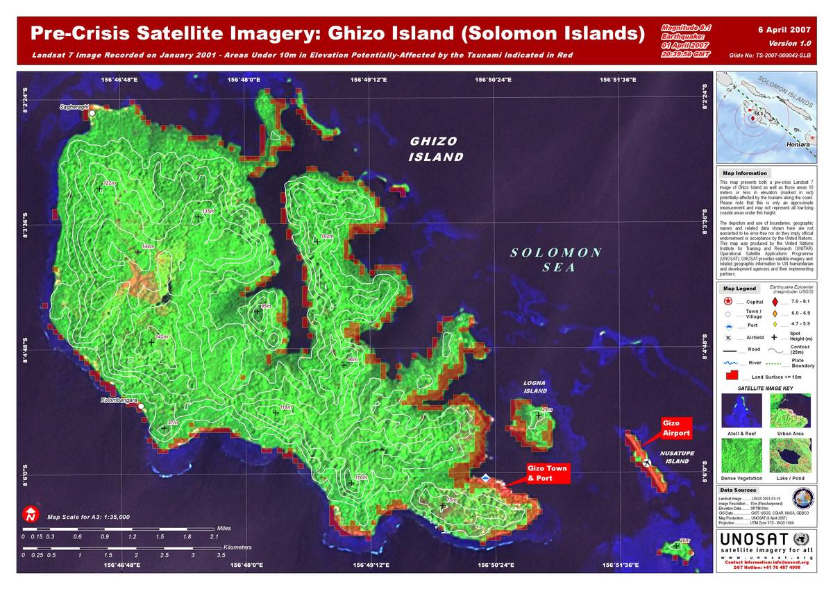
Pre-Crisis imagery, Ghizo Island
版权: Credit: USGS 2001; GIS Data: GIST, USGS, CGIAR, NASA, GEBCO Image processing, map created 06/04/2007 by UNOSAT.
Information about the Product
已获得: 19/01/2001 Pre-crisis Landsat 7 image of Ghizo Island as well as coastal areas 10 meters or less in elevation (marked in red) potentially affected by the tsunami (approximation; may not represent all low-lying coastal areas under this height).
源: Landsat-5 (pan-sharpened), resolution 15m.
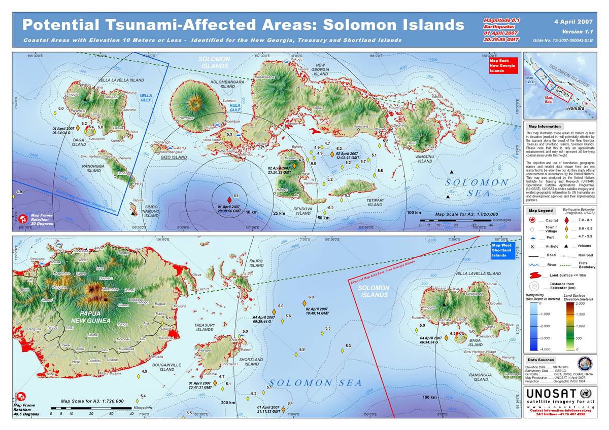
Potential Tsunami-Affected Areas, Solomon Islands, Islands; New Georgia, Treasury and Shortland groups
版权: Credits GIST, NGA, USGS, GEBCO 2004-2007 Image processing, map created 02/04/2007 by UNOSAT.
Information about the Product
已获得: Areas 10 meters and less in elevation potentially affected by the tsunami along the coast of the New Georgia and Treasury Islands, Solomon Islands.
源: SRTM dataset; Landscan 2004, resolution 90m.
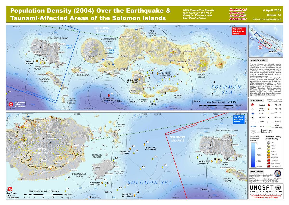
2004 Population Density, Solomon Islands, Islands; New Georgia, Treasury and Shortland groups
版权: Credits GIST, NGA, USGS, GEBCO 2004-2007 Image processing, map created 02/04/2007 by UNOSAT.
Information about the Product
已获得: 19/01/2001 2004 population density in earthquake and tsunami-affected areas of the Solomons, with two focus maps covering the New Georgia, Treasury and Shortland Island groups.
源: SRTM dataset, resolution 90m.
 返回完整的响应档案

