最新宪章启动
Charter activations
伊朗北部地震
德黑兰北部70公里的区域下午5时10分发生强烈地震(6.3级)(美国地质调查局和伊朗地质调查局)。官方称至少有23人丧生和数十人受伤。
| 事件类型: | 地震 |
| 事件地点: | 伊朗 |
| 启动宪章的日期: | 2004年5月28日 |
| 宪章要求者: | 德国联邦外交部 |
| 项目经理: | DLR |
Products

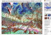
Pre-disaster overview satellite map of the Baladeh region This satellite map displays the region of Baladeh, in Northern Iran (Geographic coordinates: 36° 12' N, 51° 48'E) as imaged by Landsat satellite on July 18, 2000. The region was hit by an earthquake on May 28, 2004 in the afternoon. Because the Landsat image was taken in summer 2000, the map DOES NOT show any earthquake related damage and can only be used as an overview map.
Information about the Product
已获得: 18/07/2000
源: Landsat
 返回完整的响应档案

 English
 Spanish
 French
 Chinese
 Russian
 Portuguese


