 English
 Spanish
 French
 Chinese
 Russian
 Portuguese
 Последняя Активация
Charter activations
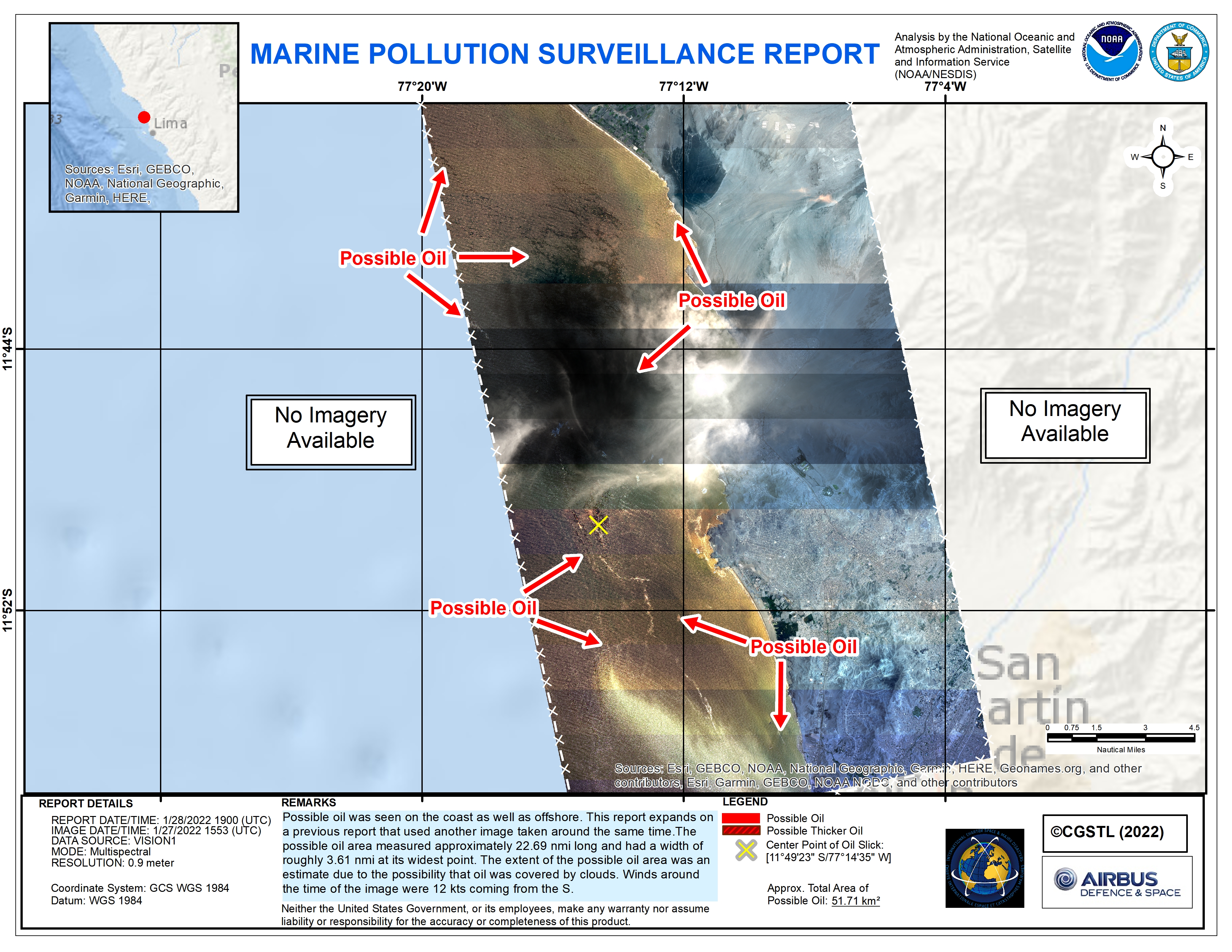
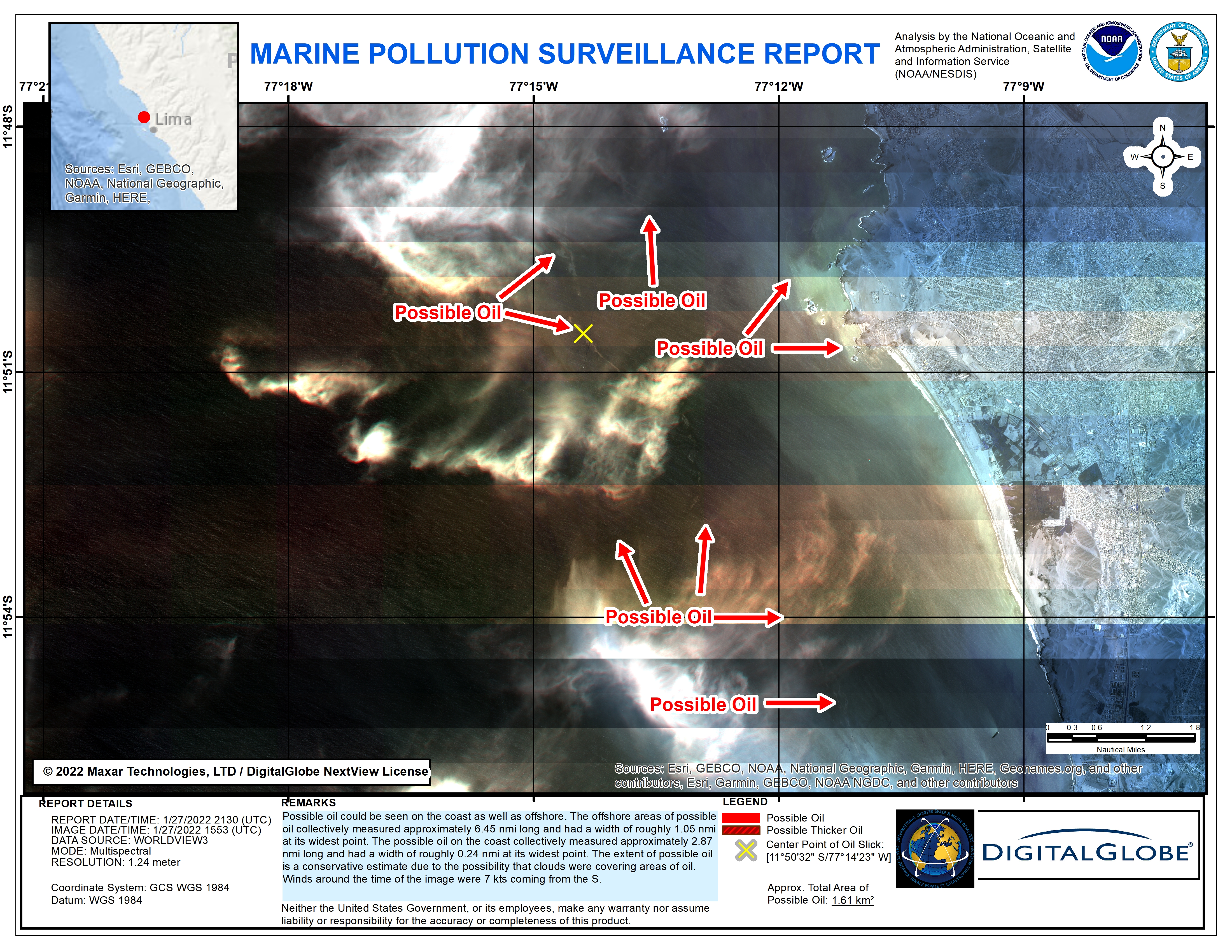
Oil spill in Peru
Authorities estimate that approximately 6,000 barrels of oil were spilled in an area of rich marine biodiversity along the coast of Peru near Ventanilla, north of Lima.
A discharge ship was rocked by waves caused by the eruption of the Tonga volcano causing the spill to occur on Sunday during unloading of crude oil from the ship to the La Pampilla refinery.
The current concern is that winds are driving the oil plume north along the coast from Ventanilla to Chancay.
| Место события: | Peru |
| Date of Charter Activation: | 2022-01-20 |
| Время активации Хартии: | 13:53 |
| TЧасовой пояс в районе активации Хартии: | UTC-06:00 |
| Запрос на активацию поступил от: | USGS on behalf of Comisión Nacional de Investigación y Desarrollo Aeroespacial (CONIDA) |
| Номер активации: | 745 |
| Менеждер проекта от: | CONIDA |
Products
Hydrocarbon Spill - Identification of Affected Areas
Авторские права: PeruSAT-1 © CONIDA 2022, distribution CONIDA/CNOIS, Republic of Peru, all rights reserved.
WorldView © (2022) DigitalGlobe, Inc., Longmont CO USA 80503. DigitalGlobe and the DigitalGlobe logos are trademarks of DigitalGlobe, Inc. The use and/or dissemination of this data and/or of any product in any way derived there from are restricted. Unauthorized use and/or dissemination is prohibited.
Map produced by MAXAR
Information about the Product
Получено: PeruSAT-1: 27/01/2022
WorldView: 27/01/2022
Источник: PeruSAT-1, WorldView-2, WorldView-3
Категория: Delineation Monitoring Maps
Areas affected by the oil spill
Авторские права: WorldView-3 © (2022) DigitalGlobe, Inc., Longmont CO USA 80503. DigitalGlobe and the DigitalGlobe logos are trademarks of DigitalGlobe, Inc. The use and/or dissemination of this data and/or of any product in any way derived there from are restricted. Unauthorized use and/or dissemination is prohibited.
PeruSAT-1 © CONIDA 2022, distribution CONIDA/CNOIS, Republic of Peru, all rights reserved.
Map produced by CONIDA
Information about the Product
Получено: 25/01/2022
Источник: WorldView-3 / PeruSAT-1
Категория: Delineation Monitoring Maps
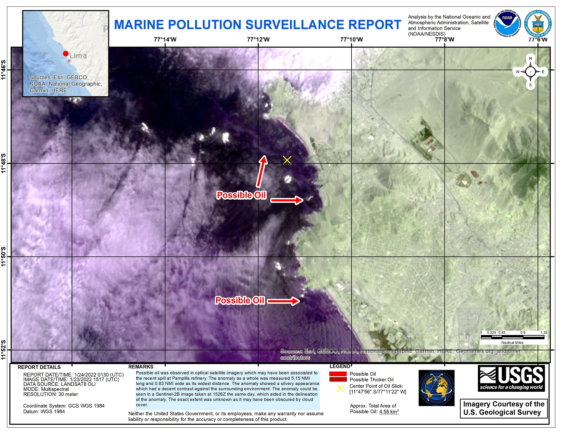
Areas affected by oil spill
Авторские права: PeruSAT-1 © CONIDA 2022, distribution CONIDA/CNOIS, Republic of Peru, all rights reserved.
Landsat data and products © NASA/USGS (2022) - All Rights Reserved.
Map produced by CONIDA
Information about the Product
Получено: PeruSAT-1: 23/01/2022
Landsat 8: 23/01/2022
Источник: PeruSAT-1 / Landsat 8
Категория: Delineation Monitoring Maps
Areas affected by oil spill in Peru
Авторские права: © (2022) DigitalGlobe, Inc., Longmont CO USA 80503. DigitalGlobe and the DigitalGlobe logos are trademarks of DigitalGlobe, Inc. The use and/or dissemination of this data and/or of any product in any way derived there from are restricted. Unauthorized use and/or dissemination is prohibited.
Map produced by CONIDA
Information about the Product
Получено: 19/01/2022
Источник: WorldView-2
Категория: Delineation Map
Preliminary identification of areas affected by the oil spill in Peru
Авторские права: © (2022) DigitalGlobe, Inc., Longmont CO USA 80503. DigitalGlobe and the DigitalGlobe logos are trademarks of DigitalGlobe, Inc. The use and/or dissemination of this data and/or of any product in any way derived there from are restricted. Unauthorized use and/or dissemination is prohibited.
Map produced by CONIDA
Information about the Product
Получено: 19/01/2022
Источник: WorldView-2
Категория: Delineation Map
Peru Oil Spill
Авторские права: Contains modified Copernicus Sentinel data (2022)
WorldView-3 © (2022) DigitalGlobe, Inc., Longmont CO USA 80503. DigitalGlobe and the DigitalGlobe logos are trademarks of DigitalGlobe, Inc. The use and/or dissemination of this data and/or of any product in any way derived there from are restricted. Unauthorized use and/or dissemination is prohibited.
Map produced by NOAA / NESDIS
Information about the Product
Получено: WorldView-3: 02/02/2022
Sentinel-2: 02/02/2022
Источник: WorldView-3 / Sentinel-2
Категория: Reference Map
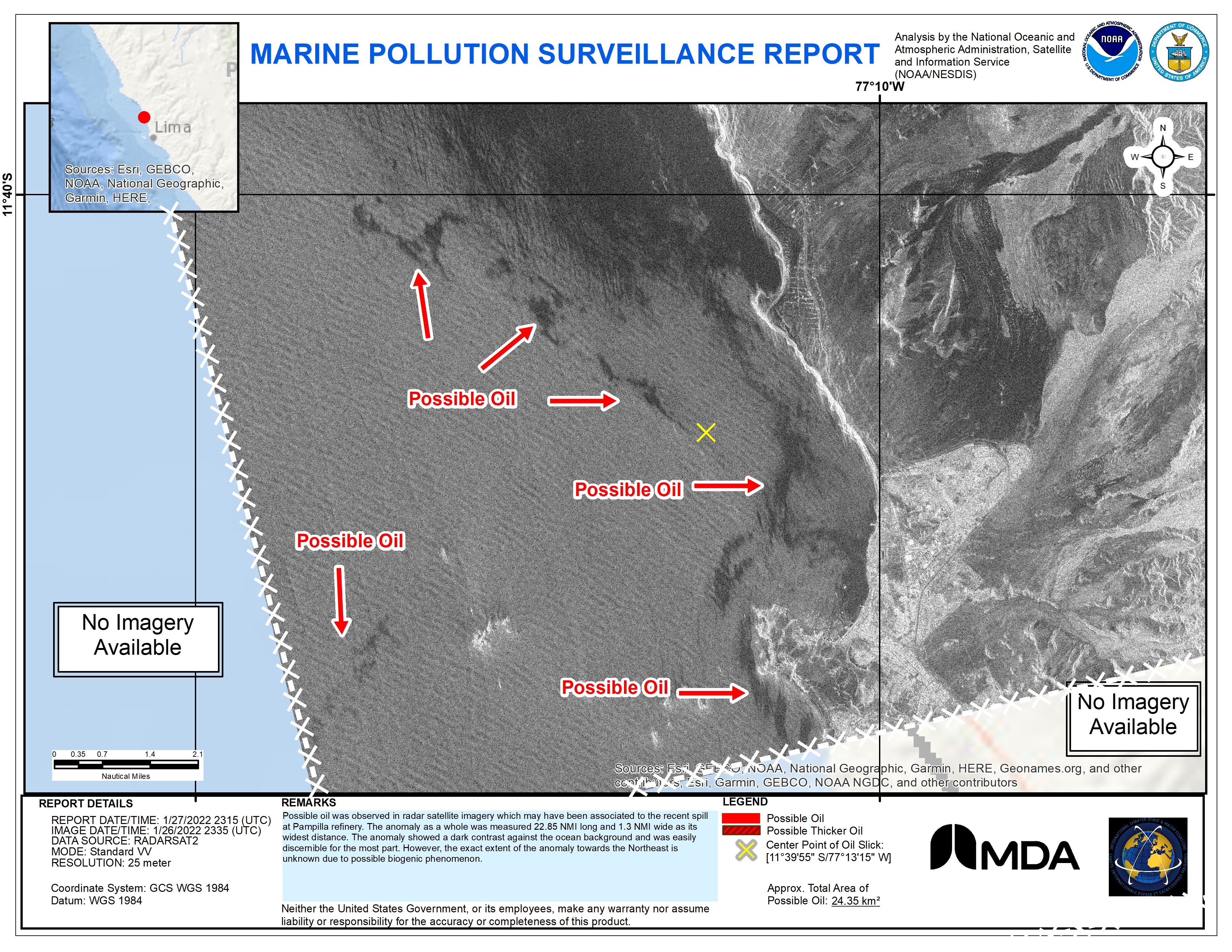
NOAA Oil Extent monitoring
Авторские права: RADARSAT-2 Data and Products © Maxar Technologies Ltd. (2022) – All Rights Reserved.
RADARSAT is an official mark of the Canadian Space Agency
Map produced by NOAA / NESDIS
Information about the Product
Получено: 26/01/2022
Источник: RADARSAT-2
Категория: Reference Map
NOAA Oil Extent Monitoring
Авторские права: © (2022) DigitalGlobe, Inc., Longmont CO USA 80503.
DigitalGlobe and the DigitalGlobe logos are trademarks of DigitalGlobe, Inc. The use and/or dissemination of this data and/or of any product in any way derived there from are restricted. Unauthorized use and/or dissemination is prohibited.
Map produced by NOAA / NESDIS
Information about the Product
Получено: 27/01/2022
Источник: WorldView-3
Категория: Reference Map
NOAA Oil Extent analysis
Авторские права: © (2022) DigitalGlobe, Inc., Longmont CO USA 80503. DigitalGlobe and the DigitalGlobe logos are trademarks of DigitalGlobe, Inc. The use and/or dissemination of this data and/or of any product in any way derived there from are restricted. Unauthorized use and/or dissemination is prohibited.
Map produced by NOAA
Information about the Product
Получено: 26/01/2022
Источник: WorldView-3
Категория: Reference Map
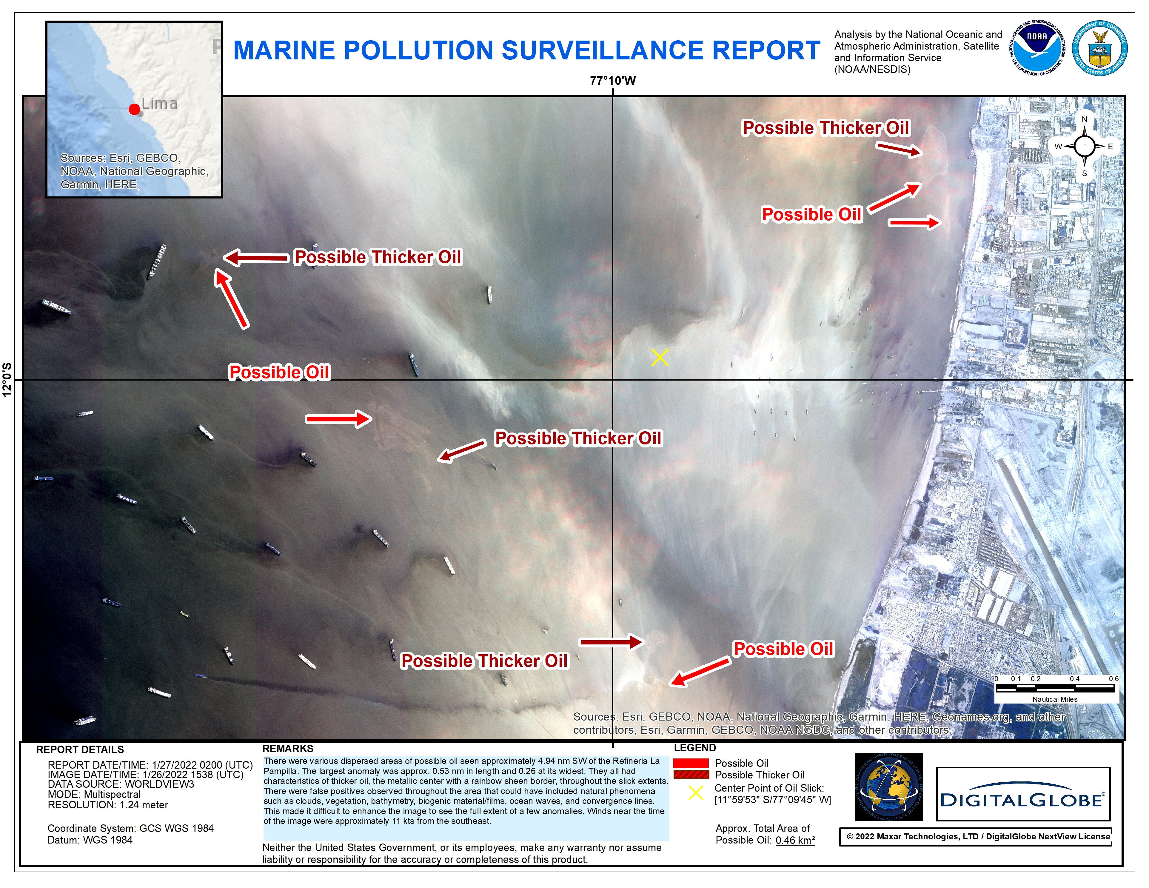
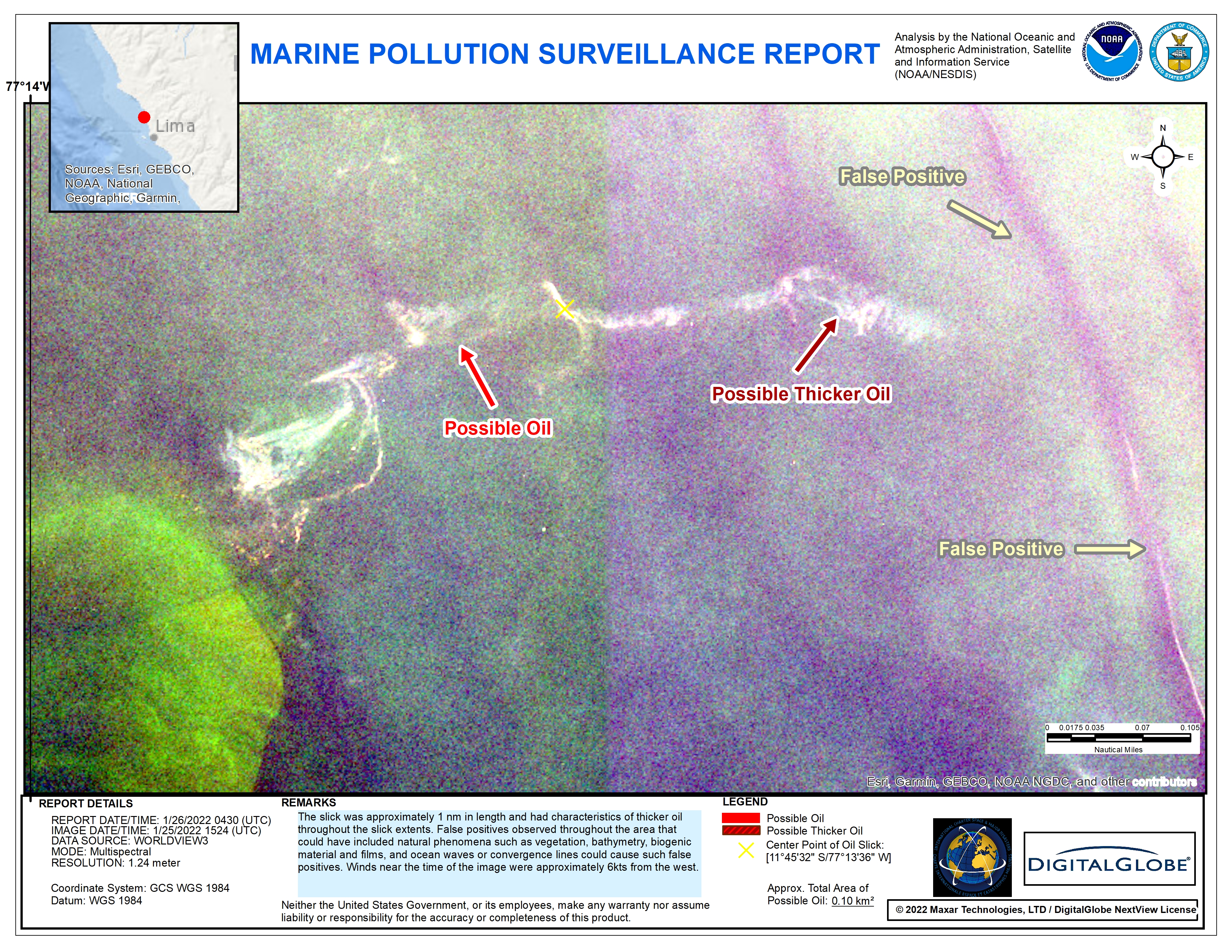
Oil Spill damage monitoring
Авторские права: © (2022) DigitalGlobe, Inc., Longmont CO USA 80503. DigitalGlobe and the DigitalGlobe logos are trademarks of DigitalGlobe, Inc. The use and/or dissemination of this data and/or of any product in any way derived there from are restricted. Unauthorized use and/or dissemination is prohibited.
Map produced by NOAA
Information about the Product
Получено: 25/01/2022
Источник: WorldView-3
Категория: Reference Map
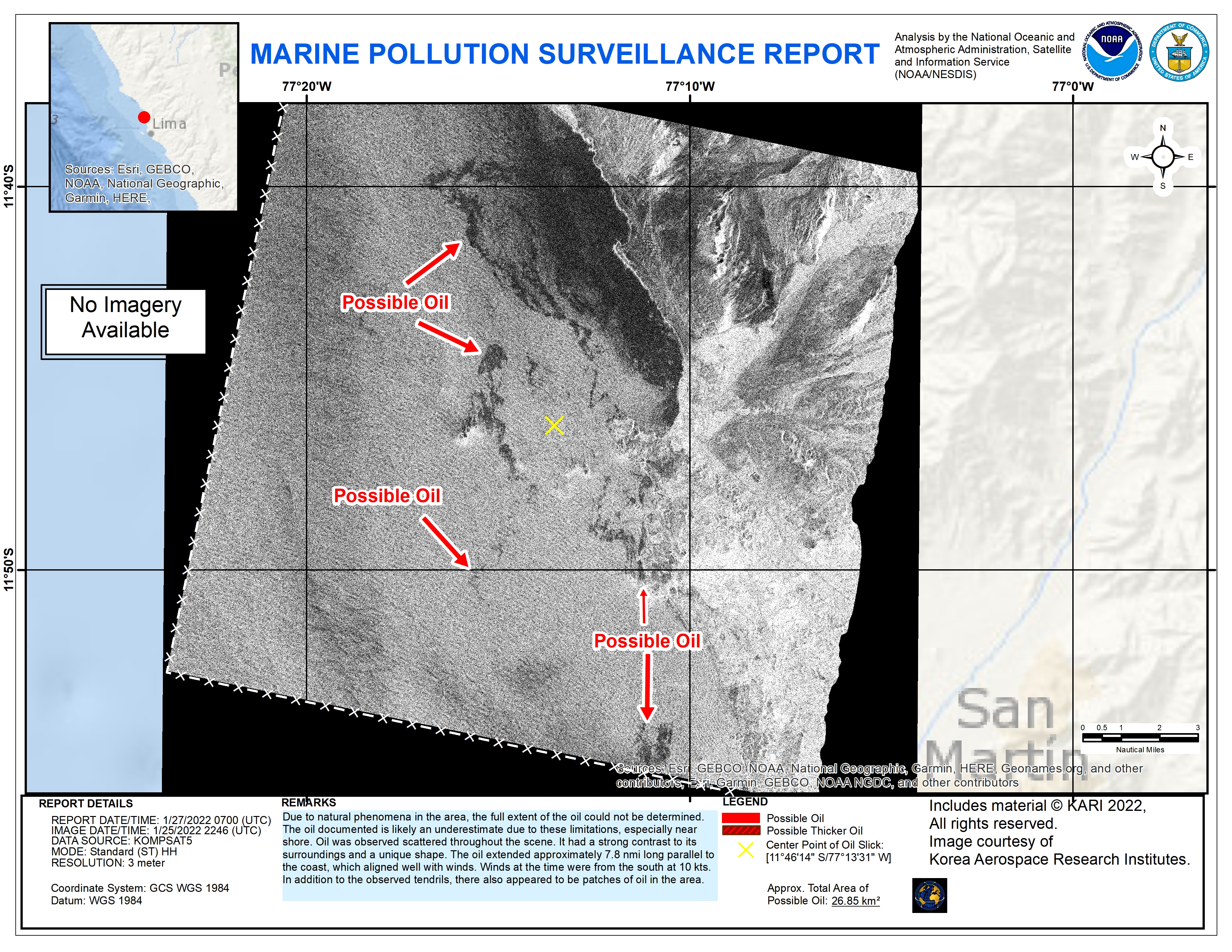
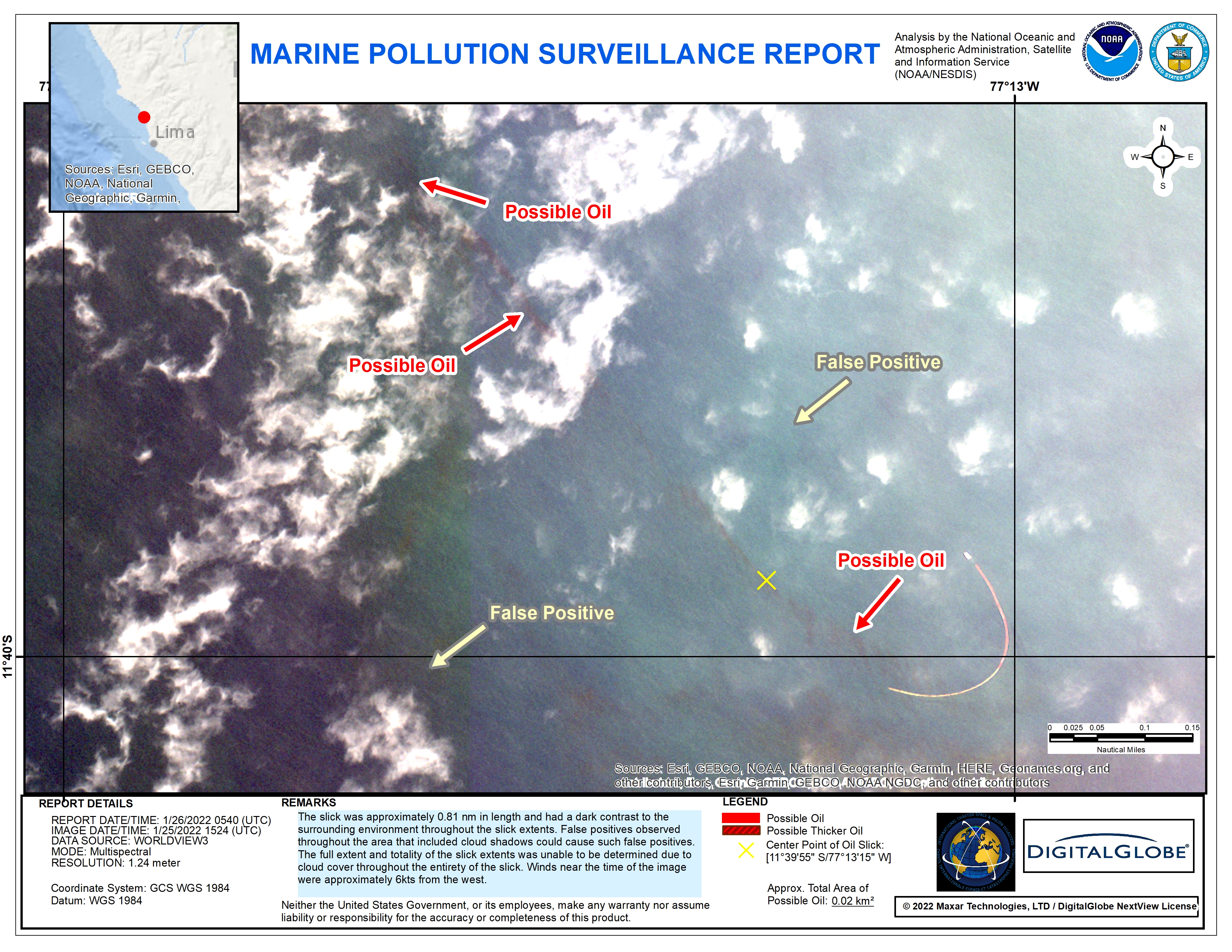
NOAA Oil Spill damage extent
Авторские права: © (2022) DigitalGlobe, Inc., Longmont CO USA 80503. DigitalGlobe and the DigitalGlobe logos are trademarks of DigitalGlobe, Inc. The use and/or dissemination of this data and/or of any product in any way derived there from are restricted. Unauthorized use and/or dissemination is prohibited.
Map produced by NOAA
Information about the Product
Получено: 25/01/2022
Источник: WorldView-3
Категория: Reference Map
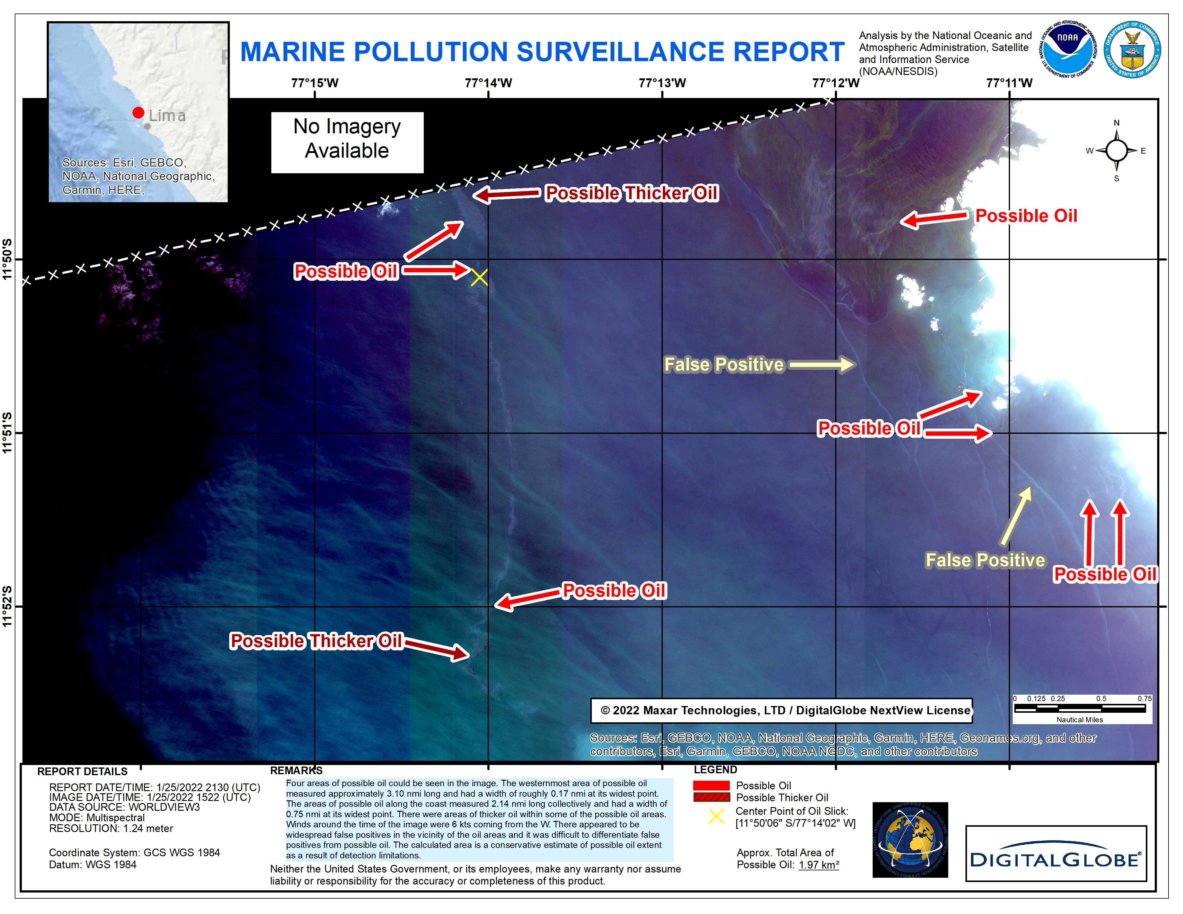
NOAA Oil Spill damage extent in Peru
Авторские права: © (2022) DigitalGlobe, Inc., Longmont CO USA 80503. DigitalGlobe and the DigitalGlobe logos are trademarks of DigitalGlobe, Inc. The use and/or dissemination of this data and/or of any product in any way derived there from are restricted. Unauthorized use and/or dissemination is prohibited.
Map produced by NOAA
Information about the Product
Получено: 25/01/2022
Источник: WorldView-3
Категория: Reference Map
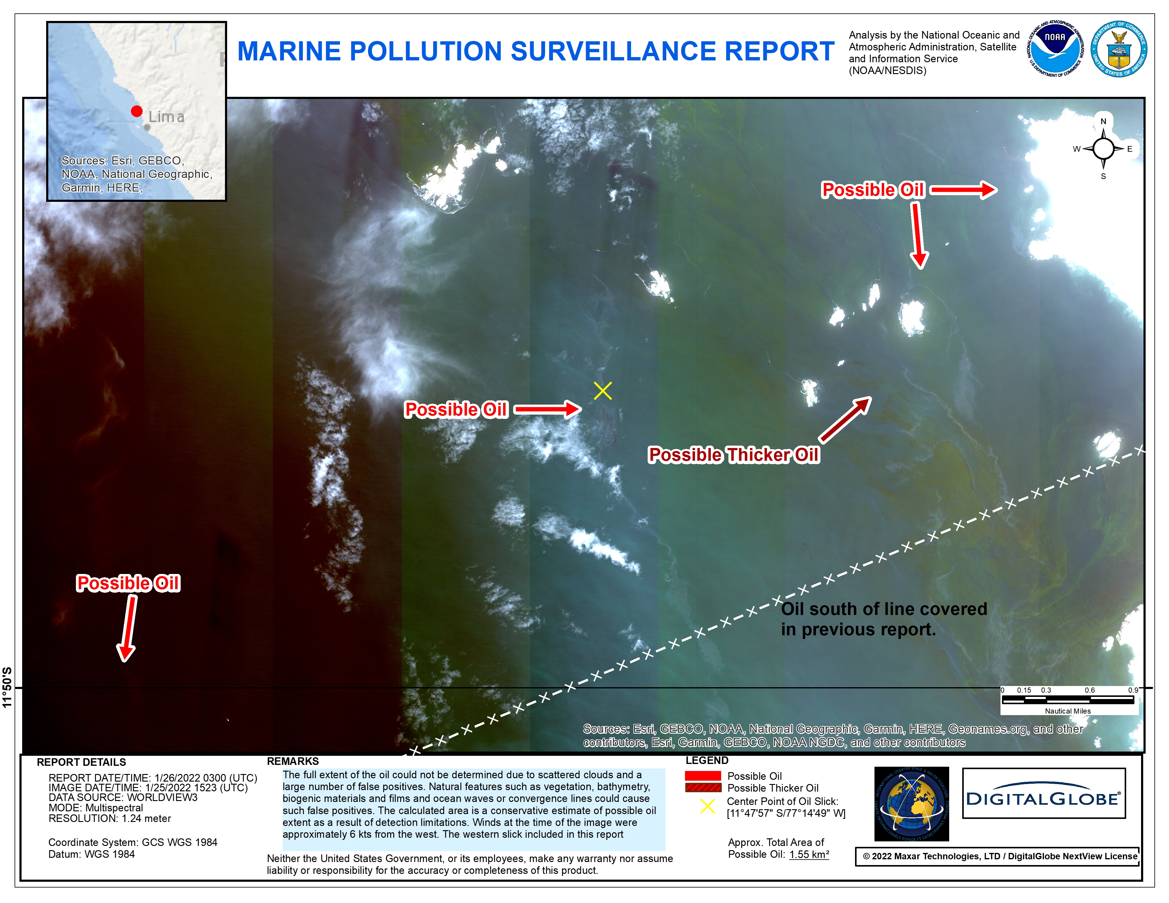
NOAA Oil Spill damage extent in Peru
Авторские права: © (2022) DigitalGlobe, Inc., Longmont CO USA 80503. DigitalGlobe and the DigitalGlobe logos are trademarks of DigitalGlobe, Inc. The use and/or dissemination of this data and/or of any product in any way derived there from are restricted. Unauthorized use and/or dissemination is prohibited.
Map produced by NOAA
Information about the Product
Получено: 25/01/2022
Источник: WorldView-3
Категория: Reference Map
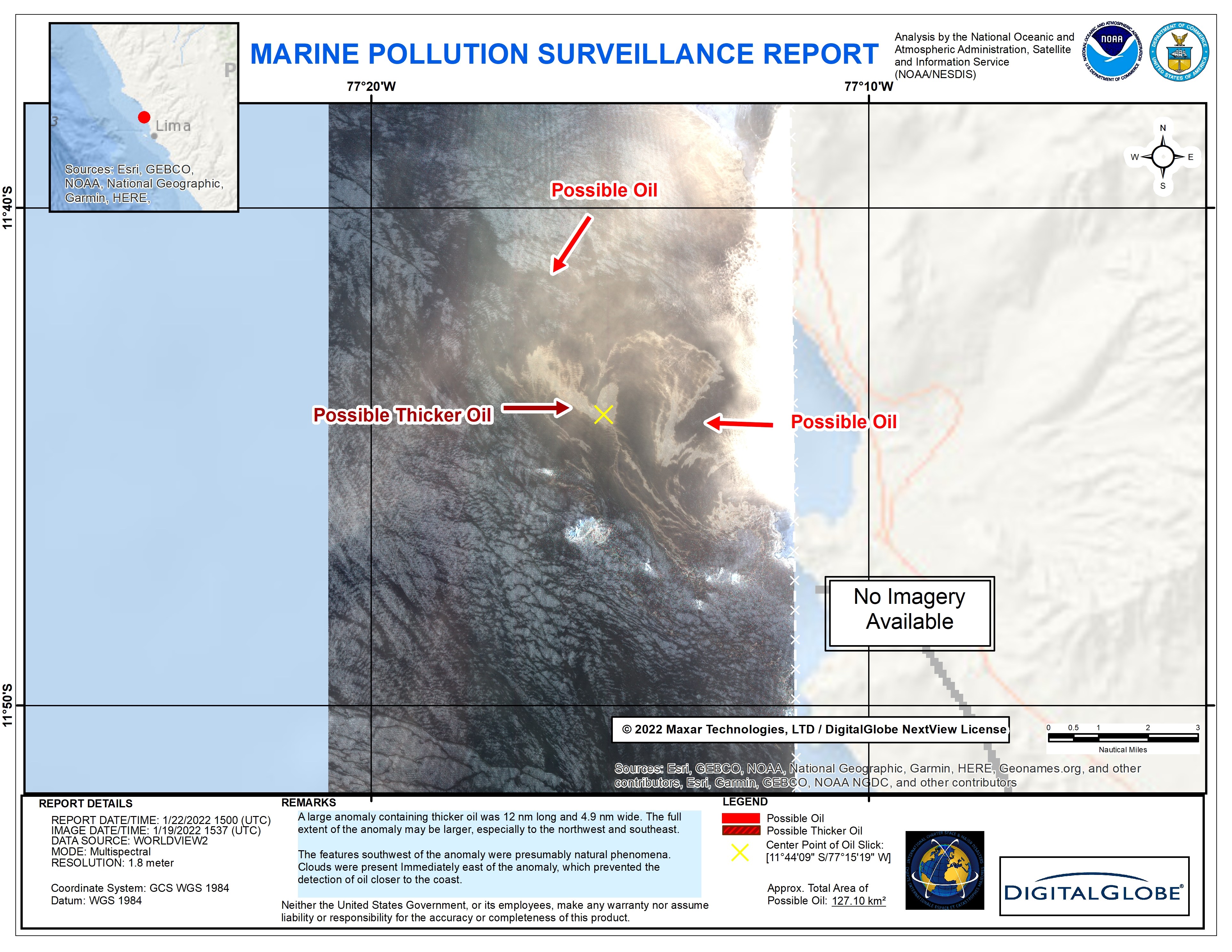
Oil spill damage extent
Авторские права: © (2022) DigitalGlobe, Inc., Longmont CO USA 80503. DigitalGlobe and the DigitalGlobe logos are trademarks of DigitalGlobe, Inc. The use and/or dissemination of this data and/or of any product in any way derived there from are restricted. Unauthorized use and/or dissemination is prohibited.
Map produced by NOAA
Information about the Product
Получено: 19/01/2022
Источник: WorldView-2
Категория: Delineation Map
 Вернуться к полному архиву активаций

