 English
 Spanish
 French
 Chinese
 Russian
 Portuguese
 Последняя Активация
Charter activations
Flood in Nigeria
Torrential rain caused flooding in Nigeria. Every state in the country was affected, but Jigawa state particularly experienced heavy flooding.
92 people were reported killed and hundreds left homeless. The floods submerged buildings and agriculture, and there were concerns that the Niger and Benue Rivers may flood as their water levels got higher.
| Тип события: | Floods |
| Место события: | Nigeria |
| Date of Charter Activation: | 2022-09-15 |
| Время активации Хартии: | 17:48 |
| TЧасовой пояс в районе активации Хартии: | UTC+02:00 |
| Запрос на активацию поступил от: | NEMA |
| Номер активации: | 777 |
| Менеждер проекта от: | Oyewumi Ademuyiwa (National Space Research and Development Agency (NASRDA)) |
| act-value-adders: | Mauro Arcorace (Terradue) |
Products
Flood extent in Ndokwa East, Oshimili South and Ogbaru LGA
Авторские права: ESRI (2022)
RADARSAT Constellation Mission Imagery © Government of Canada (2022) - RADARSAT is an official mark of the Canadian Space Agency
Map produced by National Space Research and Development Agency
Information about the Product
Получено: 12/10/2022, 17/08/2022
Источник: RCM
Категория: Delineation Monitoring Maps
Flood damage extent in Lokoja
Авторские права: World Settlement Footprint(2019)
© KARI (2022)
OpenStreetMap (2020)
Map produced by the National Space Research and Development Agency
Information about the Product
Получено: 10/04/2019, 25/09/2020, 04/10/2022
Источник: KOMPSAT-3
Категория: Reference Map
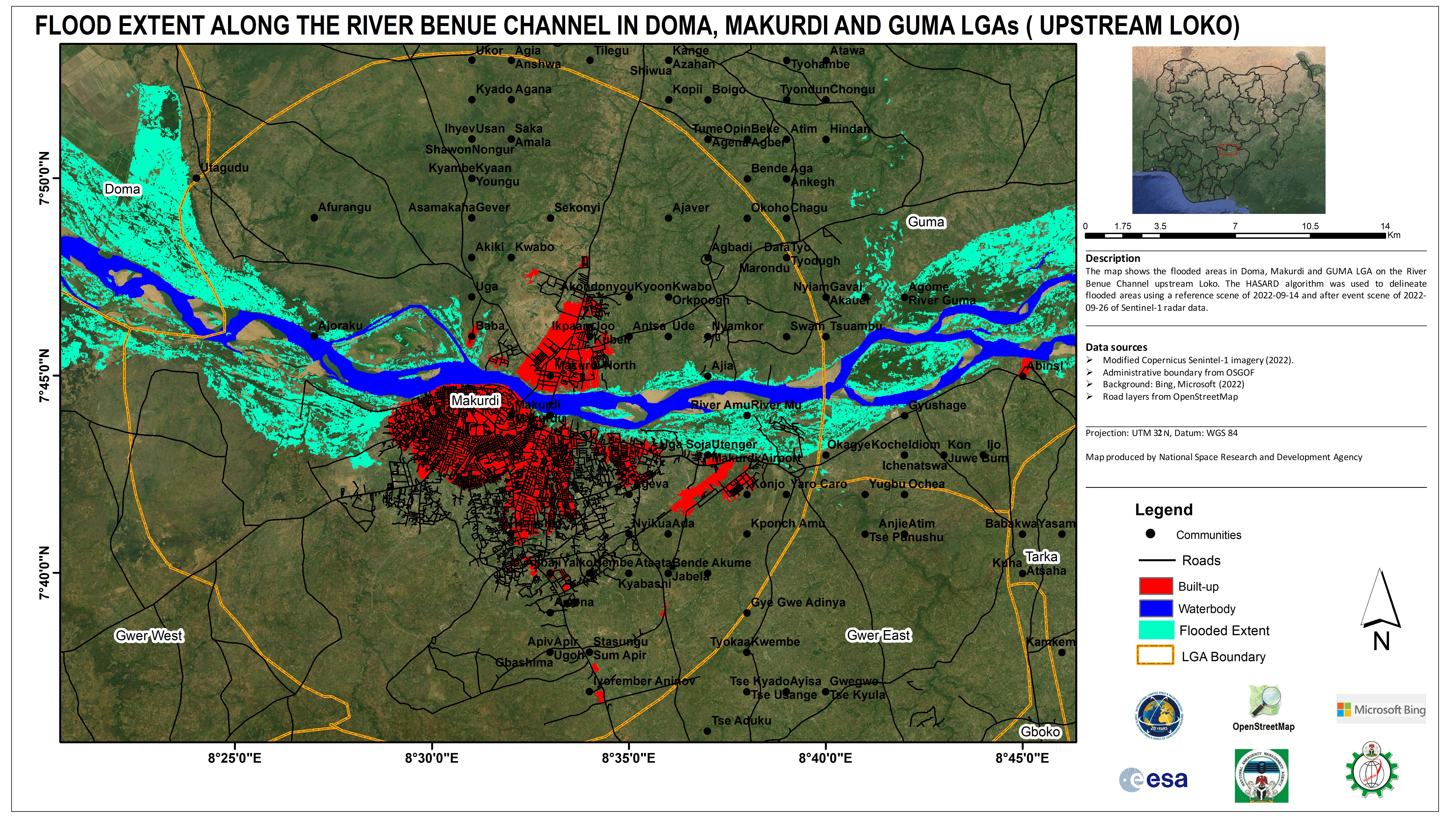
Flood extent along the river Benue in Doma, Makurdi and GUMA (Upstream Loko), Nigeria.
Авторские права: Contains modified Copernicus Sentinel data (2022)
OpenStreetMap (2020)
Map produced by the National Space Research and Development Agency
Information about the Product
Получено: 25/09/2022, 26/09/2022
Источник: Sentinel-1
Категория: Delineation Monitoring Maps
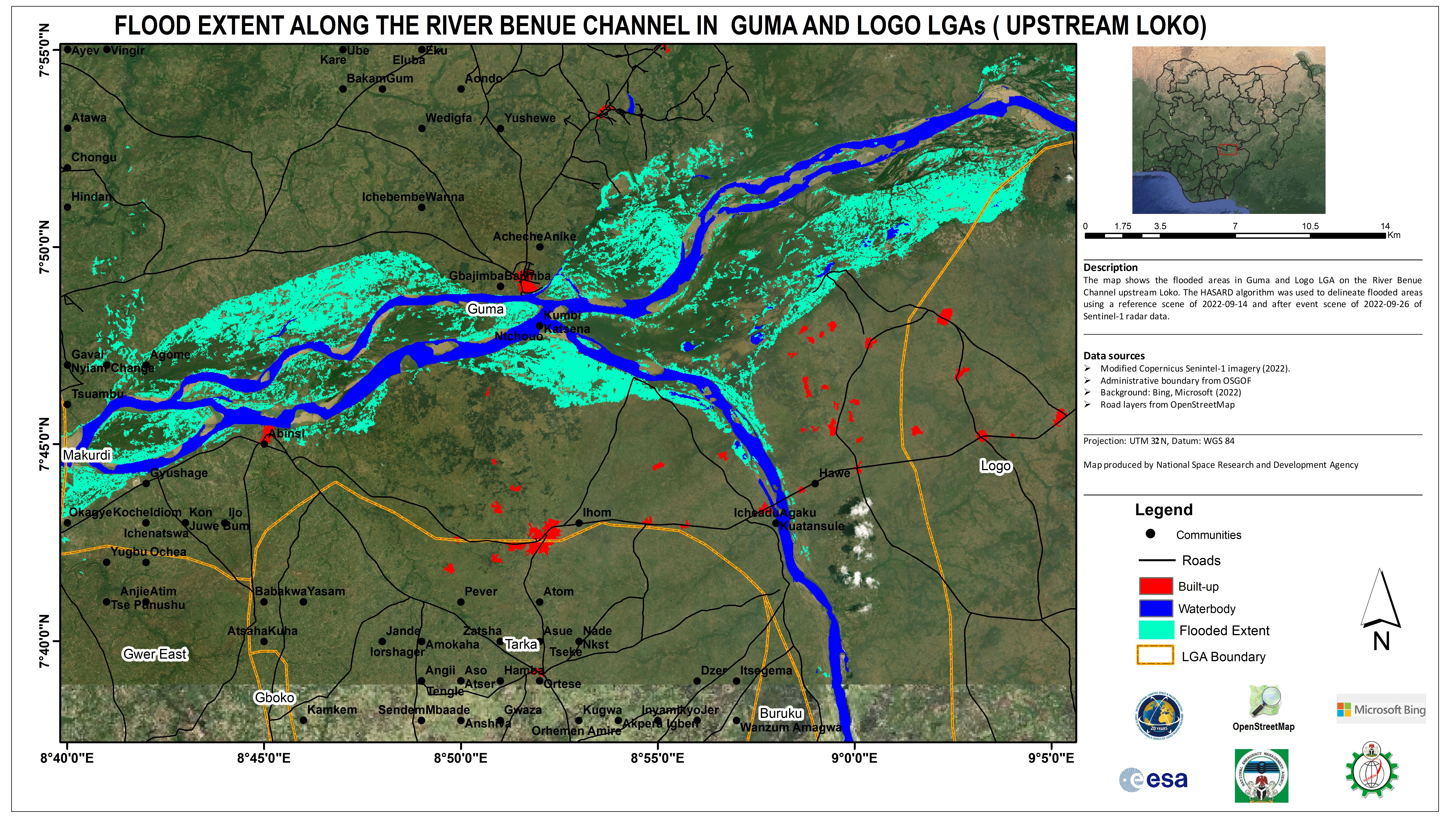
Flood extent along the river Benue in Guma and Logo LGA's (Upstream Loko), Nigeria.
Авторские права: Contains modified Copernicus Sentinel data (2022)
OpenStreetMap (2020)
Map produced by the National Space Research and Development Agency
Information about the Product
Получено: 26/09/2022
Источник: Sentinel-1
Категория: Delineation Monitoring Maps
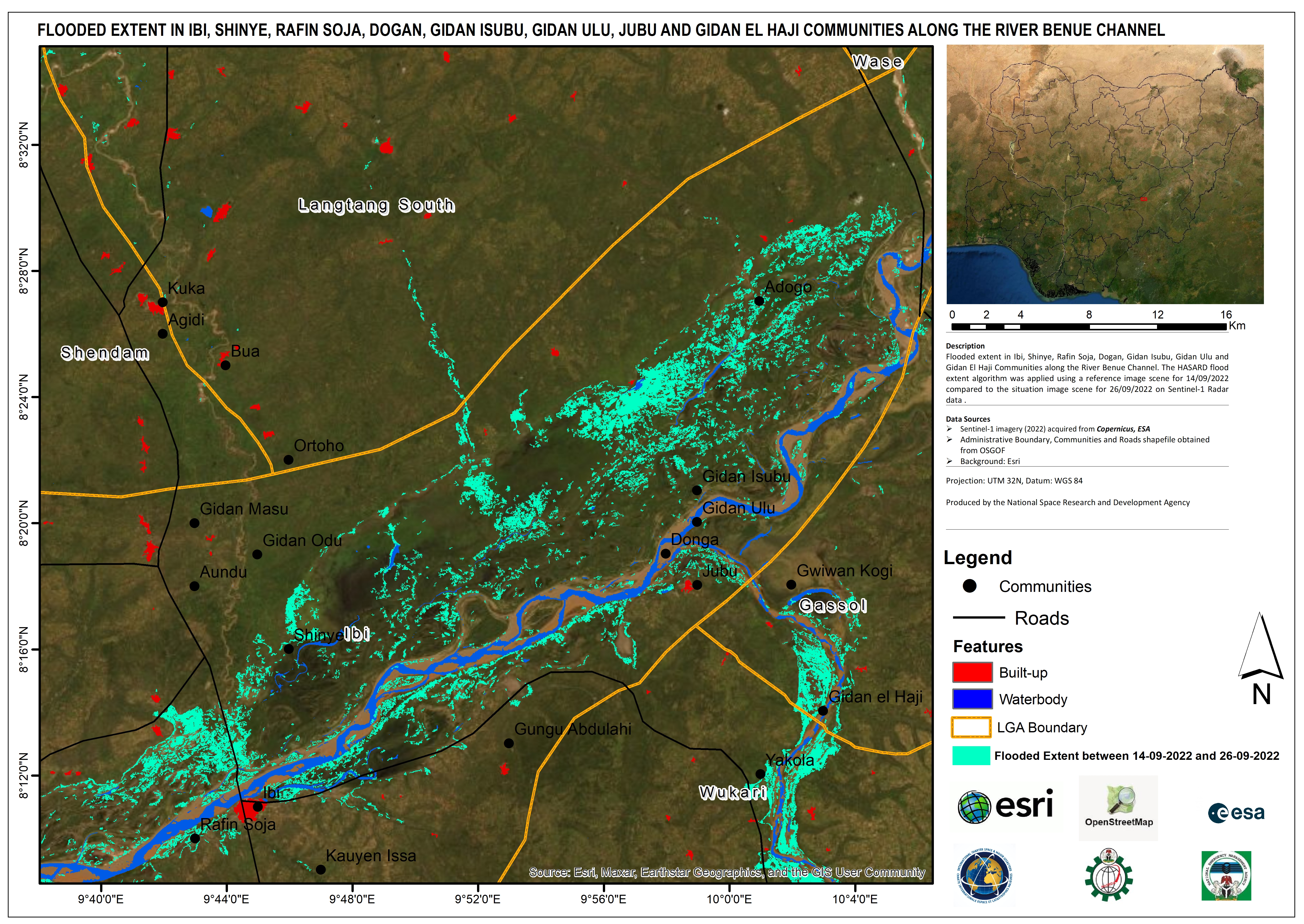
Flooded Extent in Ibi, Shinye, Rafin Soja, Dogan, Gidan Isubu, Gidan Ulu, Jubu and Gidan El Haji Communities along the River Benue Channel, Nigeria.
Авторские права: Contains modified Copernicus Sentinel data (2022)
Esri (2020)
OpenStreetMap (2020)
Map produced by the National Space Research and Development Agency
Information about the Product
Получено: 20/09/2020, 26/09/2022, 10/10/2020
Источник: Sentinel-1
Категория: Delineation Monitoring Maps
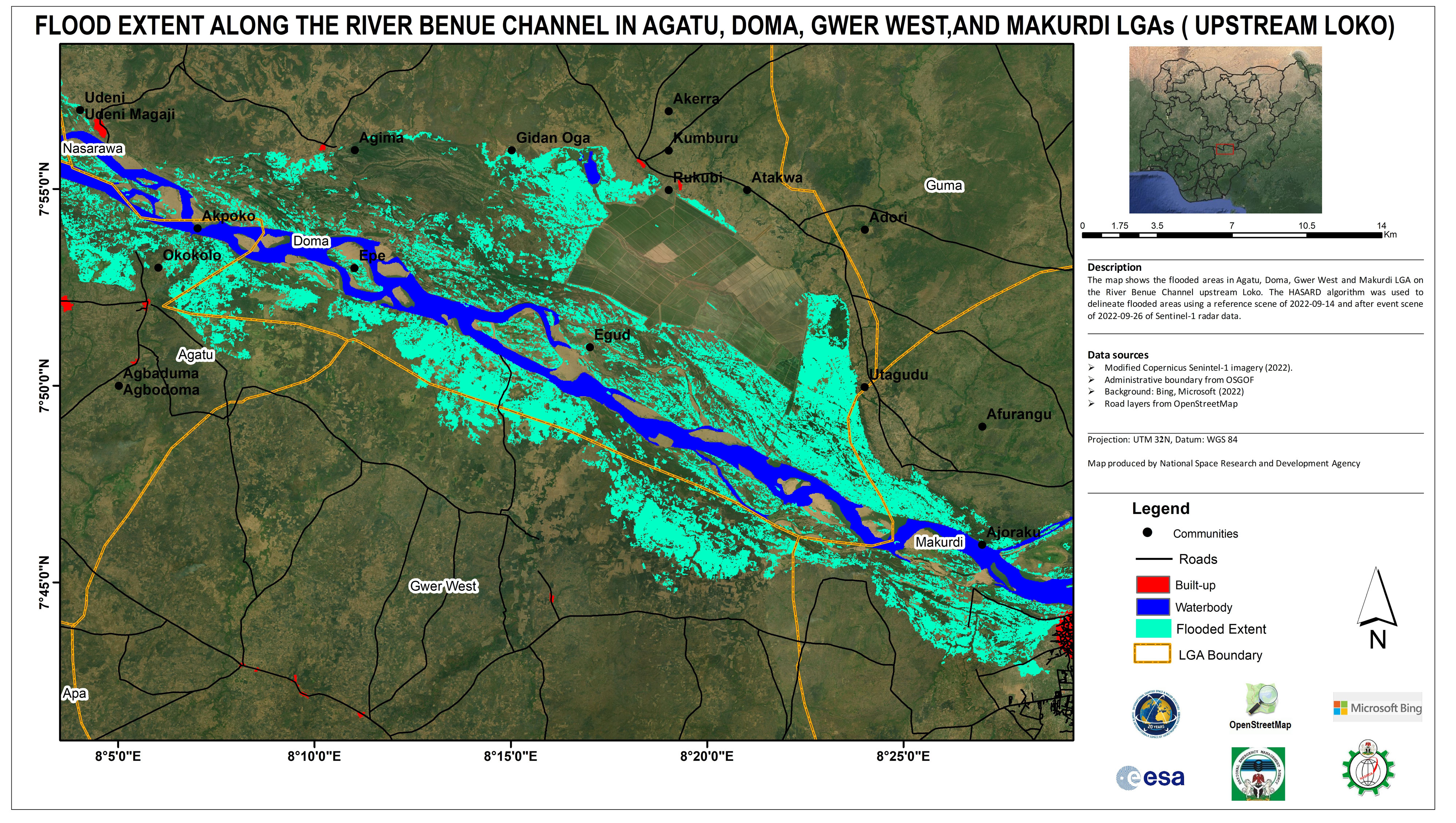
Flood extent along the river Benue channel in Agatu, Doma, Gwer West and Makurdi LGAs (Upstream Loko), Nigeria.
Авторские права: Contains modified Copernicus Sentinel data (2022)
Map produced by National Space Research and Development Agency
Information about the Product
Получено: 26/09/2022, 26/10/2022, 25/08/2022
Источник: Sentinel-1
Категория: Delineation Monitoring Maps
Flooded Area: Benue River - Niger River Confluence, Nigeria. Situation on 24/09/2022. Affected Buildings. Koton Karifi, Lokoja Close-Up.
Авторские права: Contains modified Copernicus Sentinel data (2022)
Map produced by National Space Research and Development Agency
Information about the Product
Получено: 24/09/2022
Источник: Sentinel-2
Категория: Delineation Monitoring Maps
Flooded Villages Between Ojigagala and Abujaga in Kogi State, Nigeria
Авторские права: RADARSAT Constellation Mission Imagery © Government of Canada (2022) - RADARSAT is an official mark of the Canadian Space Agency
Map produced by National Space Research and Development Agency
Information about the Product
Получено: 30/09/2022
Источник: RCM
Категория: Reference Map
Flood extent along the river Benue channel in Agatu, Doma, Gwer West and Makurdi LGA's (Upstream Loko), Nigeria
Авторские права: OpenStreetMap(2020)
Contains modified Copernicus Sentinel data (2022)
Map produced by National Space Research and Development Agency
Information about the Product
Получено: 26/09/2022
Источник: Sentinel-1
Категория: Delineation Monitoring Maps
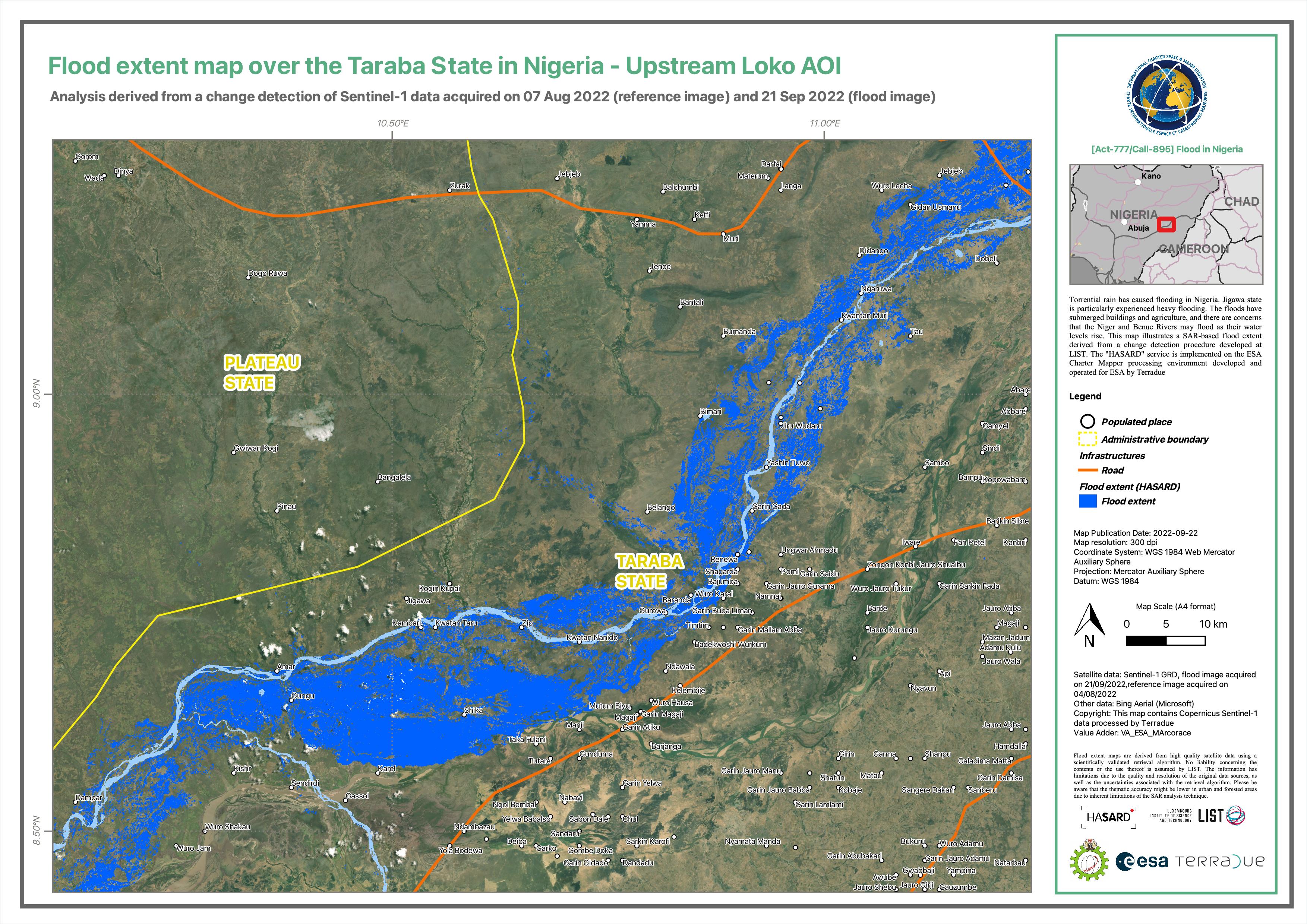
Flood extent along the river Benue channel in Benue and Taraba state (upstream loko), Nigeria
Авторские права: Contains modified Copernicus Sentinel data (2022)
Map produced by the National Space Research and Development Agency.
Information about the Product
Получено: 26/09/2022
Источник: Sentinel-1
Категория: Delineation Monitoring Maps
Inundated areas: Bantaji, Wurbo, Gian Atoro, Kwatan, Boya, Hoyan, Sakpa, and Kanon Kabawa communities along the river Benue channel
Авторские права: Contains modified Copernicus Sentinel data (2022)
Map produced by National Space Research and Development Agency.
Information about the Product
Получено: 26/09/2022
Источник: Sentinel-1
Категория: Delineation Monitoring Maps
Inundated areas: Makurdi and Doma lga along the river Benue channel - upstream loko
Авторские права: Contains modified Copernicus Sentinel data (2022)
Map produced by National Space Research and Development Agency
Information about the Product
Получено: 14/09/2022
Источник: Sentinel-1
Категория: Delineation Monitoring Maps
Inundated areas: Ohelefu west, Adeka, Olegadoba, Oweto, Oweto East and Utogo Lugw Communities along the river Benue channel
Авторские права: Contains modified Copernicus Sentinel data (2022)
OpenStreetMap (2020)
© Planet Labs Inc. (2022)
Map produced by National Space Research and Development Agency
Information about the Product
Получено: Sentinel-1: 19/09/2022
PlanetScope: 05/08/2022
Источник: Sentinel-1 and PlanetScope
Категория: Delineation Monitoring Maps
Inundated areas: Okolo community along the river Benue channel
Авторские права: Contains modified Copernicus Sentinel data (2022)
GeoEye
OpenStreetMap (2020)
Map produced by National Space Research and Development Agency
Information about the Product
Получено: 19/09/2022
Источник: Sentinel-1
Категория: Delineation Monitoring Maps
Inundated areas: Egba, Alia and Olege alla communities along the river Benue channel, Nigeria
Авторские права: Contains modified Copernicus Sentinel data (2022)
OpenStreetMap (2020)
© Planet Labs Inc. (2022)
Map produced by National Space Research and Development Agency
Information about the Product
Получено: Sentinel-1- 19/09/2022, 20/09/2020
PlanetScope: 05/08/2022
Источник: Sentinel-1 and PlanetScope
Категория: Delineation Monitoring Maps
Flooded Villages Between Loko and Ekwakwa in Benue State, Nigeria
Авторские права: Includes Pleiades material © CNES (2022), Distribution Airbus DS.
Map produced by National Space Research and Development Agency
Information about the Product
Получено: 24/09/2022
Источник: Pleiades
Категория: Delineation Monitoring Maps
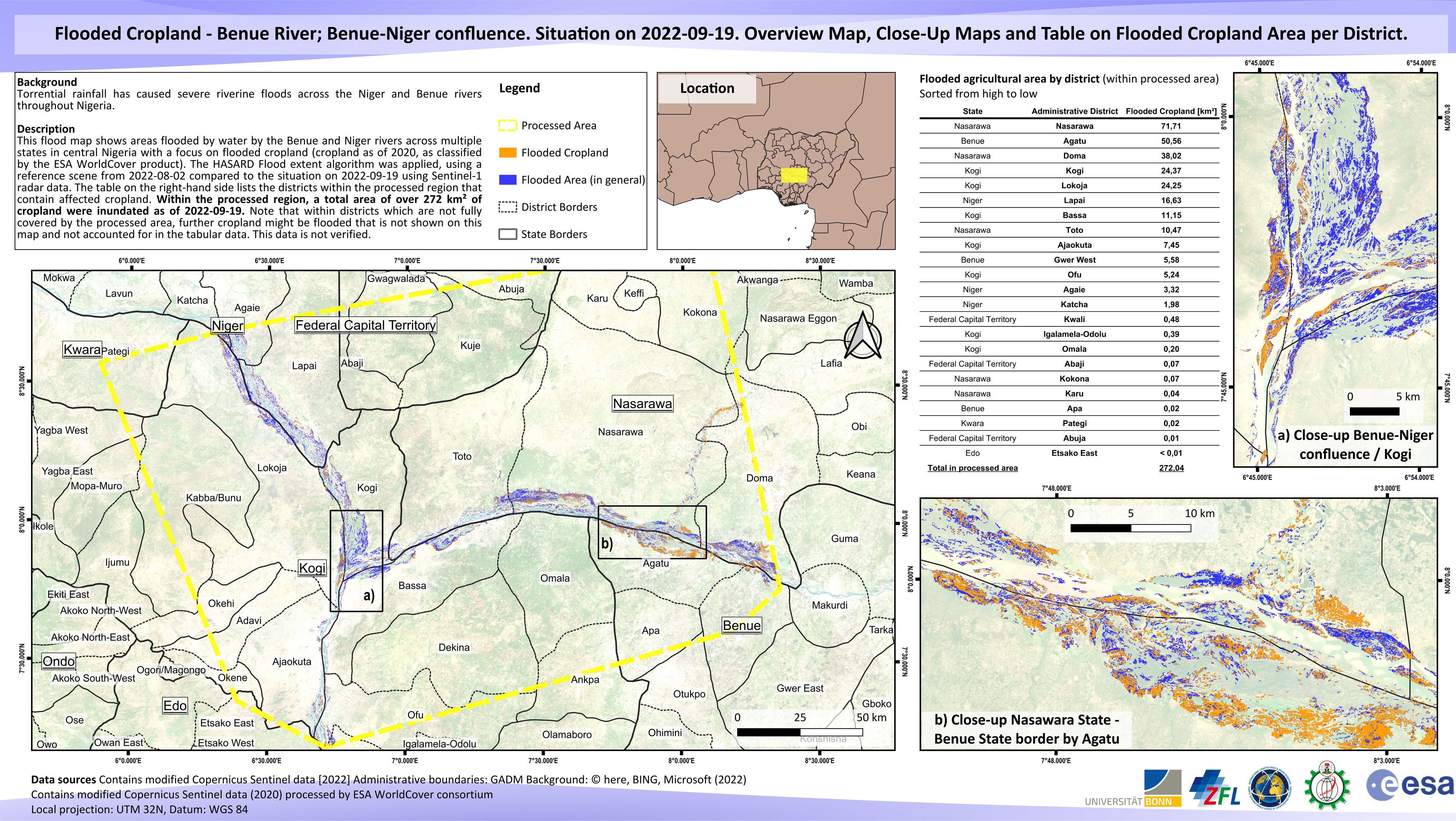
Flooded Cropland - Benue River; Benue-Niger confluence. Overview Map, Close-Up Maps and Table on Flooded Cropland Area per District.
Авторские права: Contains modified Copernicus Sentinel data (2022)
Map produced by National Space Research and Development Agency
Information about the Product
Получено: 19/09/2022
Источник: Sentinel-1
Категория: Delineation Map
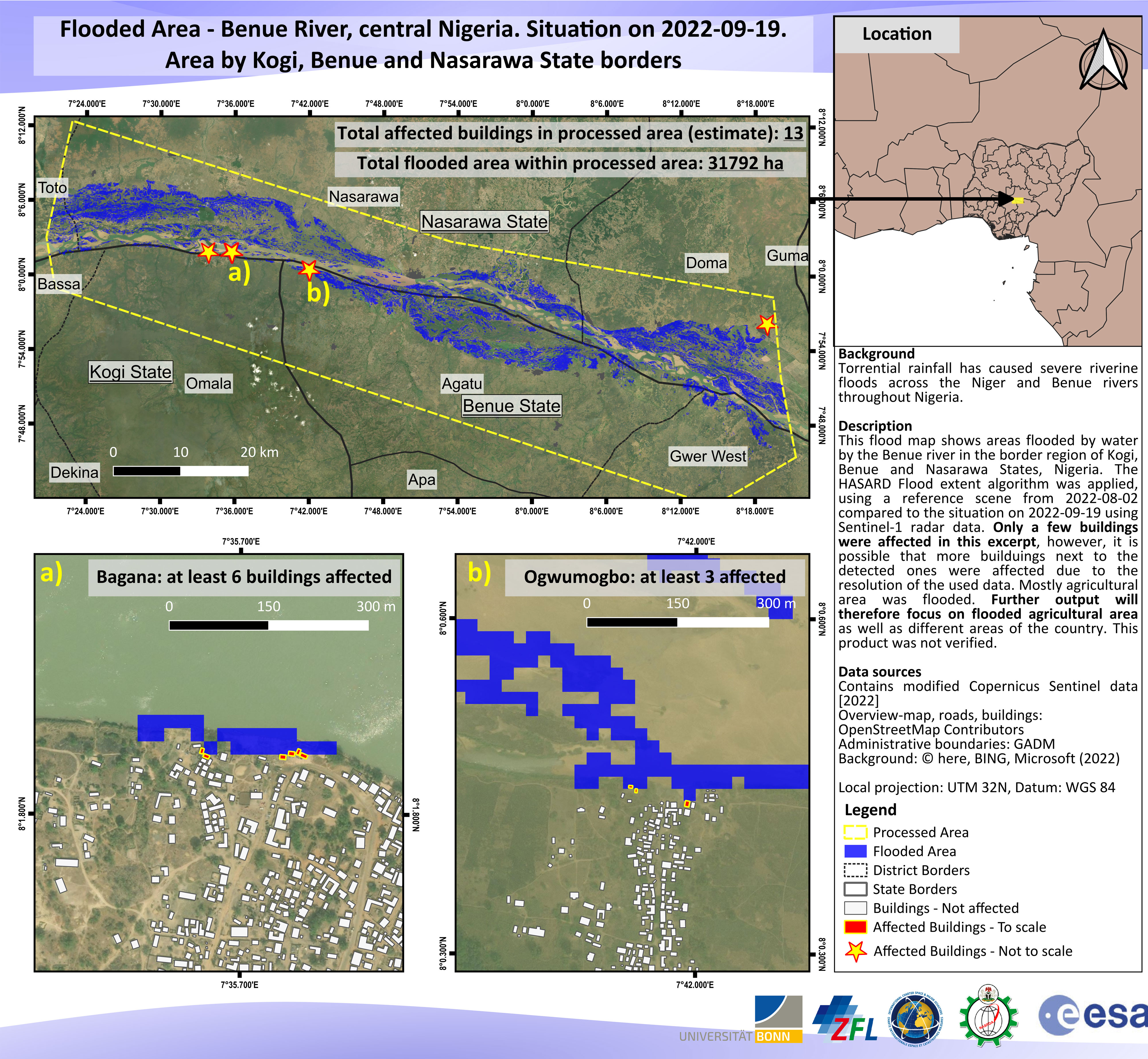
Flooded Area - Benue River, Kogi, Benue and Nasarawa State borders, central Nigeria.
Авторские права: Contains modified Copernicus Sentinel data (2022)
Map produced by National Space Research and Development Agency
Information about the Product
Получено: 19/09/2022
Источник: Sentinel-1
Категория: Delineation Map
Inundated areas: Aila community along the river Benue
Авторские права: Contains modified Copernicus Sentinel data (2022)
PlanetScope © Planet Labs Inc. (2022)
Map produced by the National Space Research and Development Agency
Information about the Product
Получено: Sentinel-1: 07/09/2022, 26/08/2022
PlanetScope: 08/08/2022
Источник: Sentinel-1 / PlanetScope
Категория: Delineation Monitoring Maps
Inundated areas: Okokolo community along the river Benue, Nigeria
Авторские права: Contains modified Copernicus Sentinel data (2022)
GeoEye
Map produced by the National Space Research and Development Agency
Information about the Product
Получено: 26/08/2022, 14/09/2022
Источник: Sentinel-1
Категория: Delineation Monitoring Maps
Inundated areas: Oweto, West Ohelefu, Adeka, Utuogolugw and Olegadoba communities along the river Benue, Nigeria
Авторские права: Contains modified Copernicus Sentinel data (2022)
© Planet Labs Inc. (2022)
Map produced by the National Space Research and Development Agency
Information about the Product
Получено: Sentinel-1: 26/08/2022, 07/09/2022
PlanetScope: 05/08/2022
Источник: Sentinel-1 / PlanetScope
Категория: Delineation Monitoring Maps
 Вернуться к полному архиву активаций

