Charter activations
Flood in Colombia
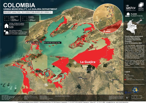
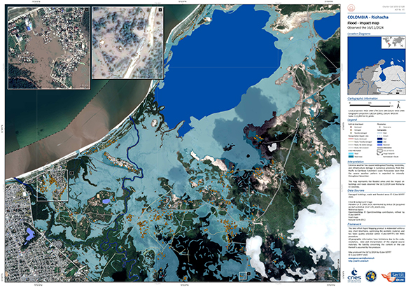
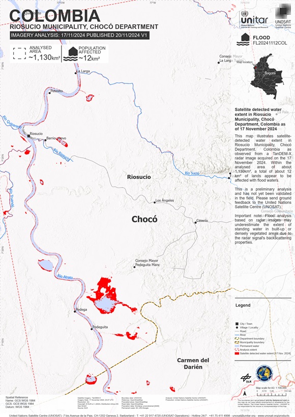
Extreme weather, has led to widespread flooding, landslides, and infrastructure damage, with no immediate relief. Dozens of communities in Colombia's Pacific coast and Andean regions were submerged under rising waters leaving 90,000 people displaced. Including communities of indigenous and Afro-Colombian peoples.
For Chocó, a department with high poverty rates and fragile infrastructure, the impact has been devastating. Official reports estimate that flooding has affected 85% of the state, displacing more than 50,000 families across 25 towns. In the Medellín, departmental capital of Antioquia, challenges are faced as heavy rains have increased the risk of landslides and flash floods, leading to road closures. Officials in Antioquia are mobilising efforts to prevent further casualties. Departments of Boyacá, Santander, and Norte de Santander are also experiencing extreme weather conditions, with hailstorms damaging local agriculture. Bogotá has also been heavily impacted from torrential rains flooding parts of the city's northern sector, including the busy Autopista Norte highway. Emergency responders worked throughout the night of 6 November to evacuate travellers trapped during rush hour on the highway, as well as students stranded inside schools.
Forecasters warn the severe weather pattern is expected to intensify throughout November. 700 communities face risks of mudslides, more than 60% of the nation's total municipalities.
Related Resources:
Web Map for Flooding in Colombia
| Тип события: | Flood |
| Место события: | Colombia |
| Date of Charter Activation: | 2024-11-14 |
| Время активации Хартии: | 10:22 |
| TЧасовой пояс в районе активации Хартии: | UTC+01:00 |
| Запрос на активацию поступил от: | UNOSAT on behalf of United Nations Office for the Coordination of Humanitarian Affairs (OCHA) |
| Номер активации: | 928 |
| Менеждер проекта от: | Teodoro Hunger (UNITAR/UNOSAT) |
| act-value-adders: | SERTIT Rapid Mapping Service (SERTIT Rapid Mapping Service) Shaikha Ahmed Albesher (Mohammed Bin Rashid Space Centre) |
Products
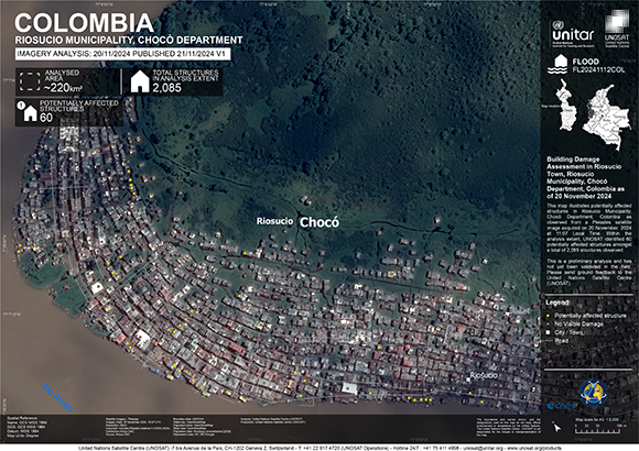
Building Damage Assessment in Riosucio Town, Riosucio Municipality, Chocó Department, Colombia
Авторские права: Includes Pleiades material © CNES (2024), Distribution Airbus DS.
Map produced by UNITAR/ UNOSAT
Information about the Product
Получено: 20/11/2024
Источник: Pleiades
Категория: Reference Map
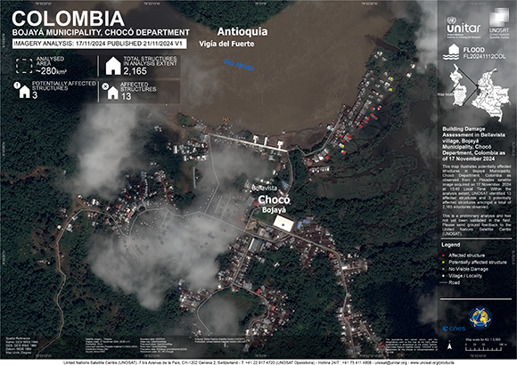
Building Damage Assessment in Bellavista village, Bojayá Municipality, Chocó Department, Colombia
Авторские права: Includes Pleiades material © CNES (2024), Distribution Airbus DS.
Map produced by UNITAR / UNOSAT
Information about the Product
Получено: 17/11/2024
Источник: Pleiades
Категория: Reference Map
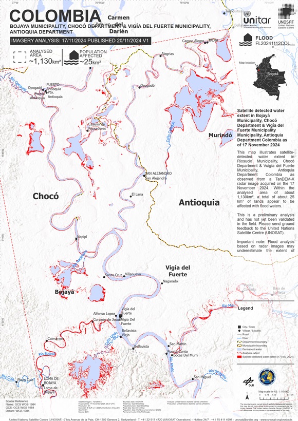
Areas affected by flooding, Chocó Department & Vigía del Fuerte Municipality Municipality, Antioquia Department Colombia
Авторские права: © DLR e.V. (2024), Distribution Airbus DS Geo GmbH
Map produced by UNITAR / UNOSAT
Information about the Product
Получено: 17/11/2024
Источник: Tandem-X
Категория: Delineation Map
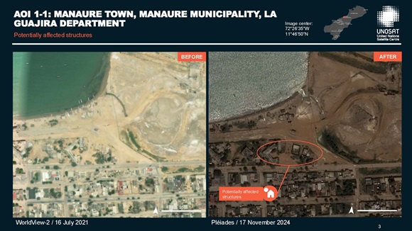
Preliminary satellite-derived flood impact assessment - Manaure & Uribia Municipalities, La Guajira Department
Download full report
Авторские права: Includes Pleiades material © CNES (2024), Distribution Airbus DS.
Report provided by UNITAR / UNOSAT
Information about the Product
Получено: 17/11/2024, 18/11/2024
Источник: Pleiades
Категория: Delineation Map

Preliminary satellite-derived flood impact assessment - Riosucio and Bojaya Municipalities, Chocó Department & Vigia del Fuerte Municipality, Antioquia - Colombia
Download full report
Авторские права: Includes Pleiades material © CNES (2024), Distribution Airbus DS.
Report produced by UNITAR / UNOSAT
Information about the Product
Получено: 16/11/2024, 17/11/2024
Источник: Pleiades
Категория: Reference Map
 Вернуться к полному архиву активаций

 English
 Spanish
 French
 Chinese
 Russian
 Portuguese
