 English
 Spanish
 French
 Chinese
 Russian
 Portuguese
 Последняя Активация
Charter activations
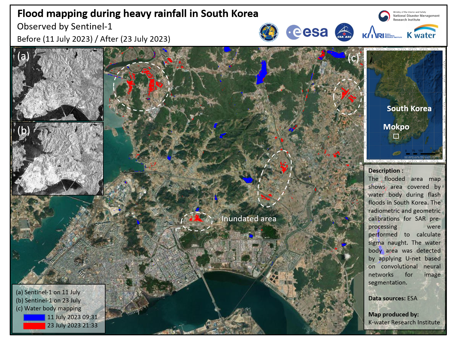
Flash Floods in South Korea
South Korea has been hit by heavy rainfall since 9 July which has intensified over the past week and is expected to continue until 23 July in some regions. The torrential rainfall has triggered flash floods and landslides across the country.
At least 46 people have been killed so far with a number injured or still missing. More than 1500 people have been forced to leave their homes to avoid floodwaters and the high risk of landslides while thousands are currently without electricity. The military has been called in to assist with the rescue operation working alongside government officials to facilitate the necessary equipment and extra manpower.
South Korea's mountainous topography makes it particularly susceptible to landslides. However, the number of casualties reported so far this monsoon season is higher than usual due to most rainfall being concentrated in more vulnerable, rural areas that are harder to monitor and reach.
In the North Chungcheong province, the Goesan Dam came extremely close to overflowing as more than 2700 tonnes of water flowed into it - the maximum amount it can discharge. Consequently, thousands of people in the surrounding area have been evacuated. All slow and bullet trains have been cancelled, due to landslide debris on tracks, while some other services have been delayed as a safety precaution.
At one stage, more than 5.5 inches (14 cm) of rain fell per hour. This is the highest hourly downpour measured in the capital since 1942. The president of South Korea, Yoon Suk Yeol, has spoken out to warn that the climate crisis has made extreme weather a fact of life while also calling for "extraordinary determination" to improve the country's preparedness and response measures.
This activation covers value added products using SAR data acquisitions over the flooding. Products acquired through optical imagery over landslides are available in our related activation.
| Тип события: | Floods |
| Место события: | South Korea |
| Date of Charter Activation: | 2023-07-16 |
| Время активации Хартии: | 11:55 |
| TЧасовой пояс в районе активации Хартии: | UTC+09:00 |
| Запрос на активацию поступил от: | National Disaster Management Institute (NDMI) |
| Номер активации: | 828 |
| Менеждер проекта от: | Hyun Ok Kim (KARI) |
| act-value-adders: | Dalgeun Lee (NDMI) Yeji Kim (KARI) |
Products
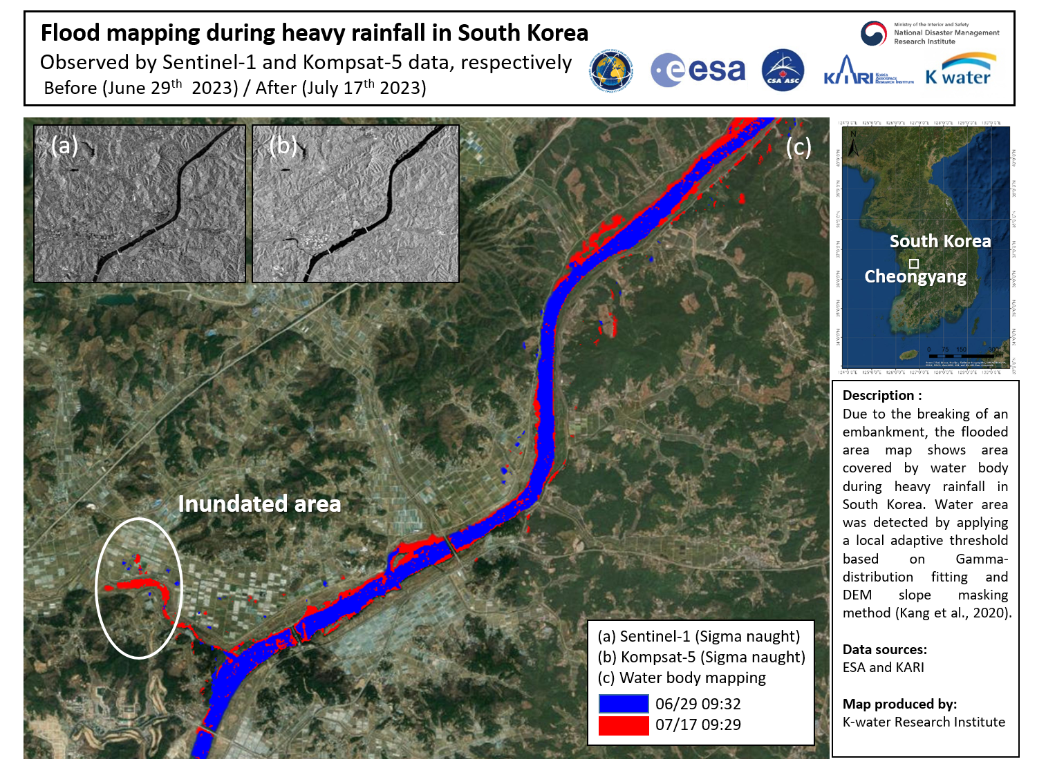
Flood Mapping during Flash Floods in South Korea
Авторские права: Contains modified Copernicus Sentinel data (2023)
© KARI (2023).
Map produced by the K-water Research Institute.
Information about the Product
Получено: Sentinel-1: 29/06/2023
KOMPSAT-5: 17/07/2023
Источник: Sentinel-1 and KOMPSAT-5
Категория: Delineation Map
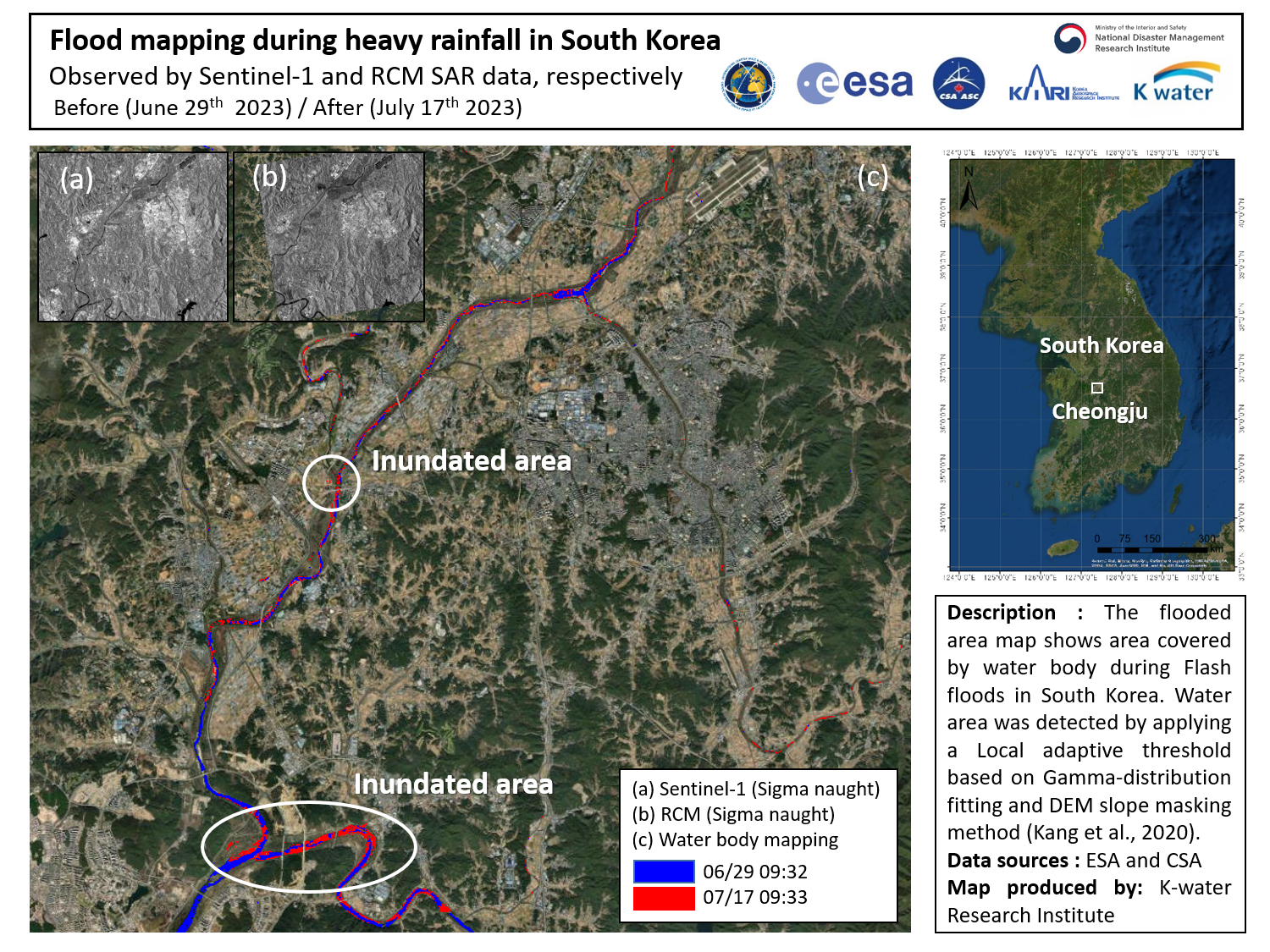
Flood mapping during heavy rainfall in South Korea
Авторские права: RADARSAT Constellation Mission Imagery © Government of Canada (2023) - RADARSAT is an official mark of the Canadian Space Agency
Contains modified Copernicus Sentinel data (2023)
Map produced by K-water Research Institute.
Information about the Product
Получено: RCM: 17/07/2023
Sentinel-1: 29/06/2023
Источник: RCM and Sentinel-1
Категория: Delineation Map
 Вернуться к полному архиву активаций

