Charter activations
Cyclone Pam in Vanuatu
Cyclone Pam passed over Vanuatu on 13 and 14 March 2015, killing at least eleven people, and leaving devastation in its wake.
The destruction from the storm has been described as the worst disaster in Vanuatu's history. Vanuatu is an island nation in the south Pacific, composed of 82 islands.
Pam passed close to the island of Efate, upon which is located Vanuatu's capital city, Port Vila, on 13 March. At the time the storm was at Category Five strength, the highest on the Saffir-Simpson Scale.
From there, the storm moved south, over Erromango and Tanna islands, and passed Aneityum island on 14 March.
The President of Vanuatu made an appeal on 14 March for international aid, describing the devastation wrought by the storm. It is reported that 90% of Port Vila has been destroyed, and that almost every house in the city has suffered at least some damage. While early warnings of the impending cyclone meant that residents had time to take shelter in emergency centres, the storm's powerful winds through wooden homes and power lines and left debris scattered across the area.
Recovery efforts began shortly after the storm passed, and international aid has been arriving in the archipelago. Tens of thousands of people are known to have been left homeless. But the southern islands are of great concern to emergency workers, as communications were severed with them by the storm. The full extent of the situation on these islands is unknown, and flooding from the cyclone has made it difficult or impossible for planes to land on the islands.
On 17 March, aid began to reach the other affected islands, and emergency workers are assessing the needs of residents there. They found that 80% of buildings on Tanna Island, which is home to 30,000 people, had been either destroyed or damaged by Cyclone Pam.
| Тип события: | Cyclone |
| Место события: | Vanuatu |
| Date of Charter Activation: | 12 March 2015 |
| Время активации Хартии: | 14:14:52 |
| TЧасовой пояс в районе активации Хартии: | UTC+01:00 |
| Запрос на активацию поступил от: | UNITAR/UNOSAT on behalf of UNOCHA |
| Менеждер проекта от: | UNITAR/UNOSAT |
Products

Satellite image detected damage estimates in Vanuatu
Download the full report
Авторские права: WorldView-1 and 2 © DigitalGlobe Inc.
Pleiades © CNES 2015 - Distribution: Airbus Defence and Space, all rights reserved
Report produced by UNITAR/UNOSAT
Information about the Product
Получено: WorldView-1: 17/03/2015
WorldView-2: 15/03/2015, 16/03/2015, 18/03/2015
Pleiades: 15/03/2015, 16/03/2015, 17/03/2015, 19/03/2015
Источник: WorldView-1 / WorldView-2 / Pleiades
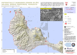
Potentially damaged zones in Epi Island, Shefa Province, in Vanuatu
Авторские права: DigitalGlobe Inc.
Map produced by UNITAR/UNOSAT
Information about the Product
Получено: 17/03/2015
Источник: WorldView-1
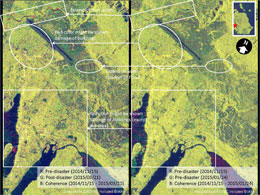
Other Result
Analytical result of Cyclone Pam in Vanuatu
Download the full report
Авторские права: RESTEC / JAXA
Report created by JAXA
Information about the Product
Получено: 15/11/2014, 24/01/2015, 21/03/2015
Источник: ALOS-2/PALSAR-2
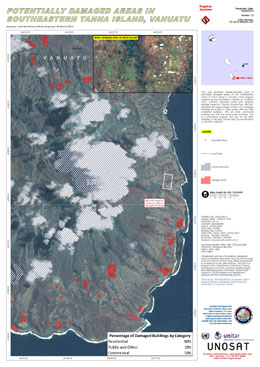
Potentially damaged areas in southeastern Tanna Island, Vanuatu
Авторские права: DigitalGlobe Inc.
Map produced by UNITAR/UNOSAT
Information about the Product
Получено: 18/03/2015
Источник: WorldView-2
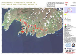
Potentially damages zones in southern Efate Island, Vanuatu
Авторские права: Pleiades © CNES 2015 - Distribution: Airbus Defence and Space, all rights reserved
WorldView-2 © DigitalGlobe Inc.
Map produced by UNITAR/UNOSAT
Information about the Product
Получено: Pleiades: 15/03/2015 and 16/03/2015
WorldView-2: 15/03/2015
Источник: Pleiades / WorldView-2
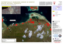
Potentially damaged areas in north Efate Island, Vanuatu
Авторские права: DigitalGlobe
Map produced by UNITAR/UNOSAT
Information about the Product
Получено: 16/03/2015
Источник: WorldView-2
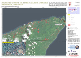
Damaged zones in Ambae Island, Penama Province, in Vanuatu
Авторские права: CNES 2015 - Distribution: Airbus Defence and Space, all rights reserved
Map produced by UNITAR/UNOSAT
Information about the Product
Получено: 19/03/2015
Источник: Pleiades
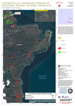
Potentially damaged areas in eastern Tanna Island, Vanuatu
Авторские права: CNES 2015 - Distribution: Airbus Defence and Space, all rights reserved
Map produced by UNITAR/UNOSAT
Information about the Product
Получено: 17/03/2015
Источник: Pleiades
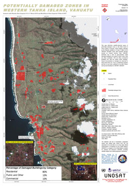
Potentially damaged zones in western Tanna Island, Vanuatu
Авторские права: Pleiades © CNES 2015 - Distribution: Airbus Defence and Space, all rights reserved
WorldView-2 © DigitalGlobe Inc.
Map produced by UNITAR/UNOSAT
Information about the Product
Получено: Pleiades: 15/03/2015 and 17/03/2015
WorldView-2: 15/03/2015
Источник: Pleiades / WorldView-2
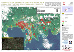
Potentially damaged zones in Port Vila, southwest Efate Island, Vanuatu
Авторские права: CNES 2015 - Distribution: Airbus Defence and Space, all rights reserved
Map produced by UNITAR/UNOSAT
Information about the Product
Получено: 15/03/2015 and 16/03/2015
Источник: Pleiades
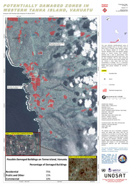
Potentially damaged zones in western Tanna island, Vanuatu
Авторские права: CNES 2015 - Distribution: Airbus Defence and Space, all rights reserved
Map produced by UNITAR/UNOSAT
Information about the Product
Получено: 15/03/2015
Источник: Pleiades
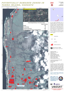
Potentially damaged zones in Tanna island, Vanuatu
Авторские права: CNES 2015 - Distribution: Airbus Defence and Space, all rights reserved
Map produced by UNITAR/UNOSAT
Information about the Product
Получено: 15/03/2015
Источник: Pleiades
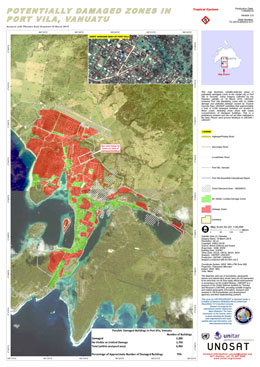
Potentially damaged zones in Port Vila, Vanuatu
Авторские права: CNES 2015 - Distribution: Airbus Defence and Space, all rights reserved
Map produced by UNITAR/UNOSAT
Information about the Product
Получено: 16/03/2015
Источник: Pleiades
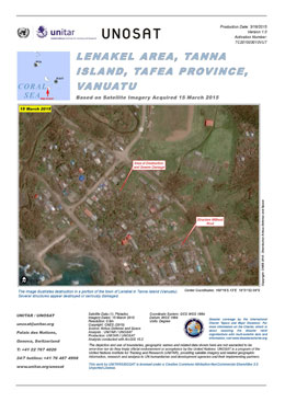
Destruction in the Lenakel area, Tanna island, in Tafea Province, Vanuatu, after Cyclone Pam.
Авторские права: CNES 2015 - Distribution: Airbus Defence and Space, all rights reserved
Map produced by UNITAR/UNOSAT
Information about the Product
Получено: 15/03/2015
Источник: Pleiades
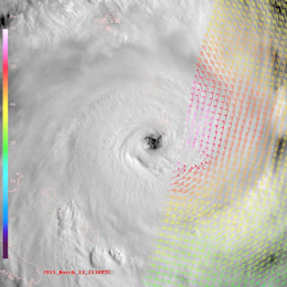
MTSAT view of the eye of Cyclone Pam on 13 March 2015, south of Port Vila.
Read more about the image in EUMETSAT's case study.
Авторские права: EUMETSAT
Information about the Product
Получено: 13/03/2015
Источник: MTSAT / MetOp
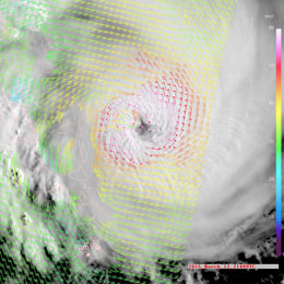
MTSAT view of Cyclone Pam on 12 March 2015 off the coast of Vanuatu.
Read more about the image in EUMETSAT's case study.
Авторские права: EUMETSAT
Information about the Product
Получено: 12/03/2015
Источник: MTSAT / MetOp
 Вернуться к полному архиву активаций

 English
 Spanish
 French
 Chinese
 Russian
 Portuguese


