 English
 Spanish
 French
 Chinese
 Russian
 Portuguese
 Latest Activation
Charter activations
Hurricane Otis in Mexico
Hurricane Otis roared ashore on Mexico's pacific coast shortly after midnight on Wednesday 25 October 2023 with 165mph winds and torrential rainfall, Acapulco was among the areas worst hit with 80% of the resort's hotels damaged and streets flooded.
Otis is the strongest ever storm to make landfall on Mexico's west coast. The hurricane underwent explosive intensification from a Category 1 to Category 5 in just 12 hours, catching forecasters by surprise.
It took nearly a full day for authorities to partially reopen the main highway connecting Acapulco to the state capital Chilpancingo and Mexico City. The vital ground link allowed dozens of emergency vehicles, personnel and trucks carrying supplies to reach the battered city's port.
Acapulco's commercial and military airports were still too badly damaged to resume flights, though Mexico's president said the plan was to establish an air bridge to move in resources to help set up rescue operations.
Related News and Resources
- Download a GeoJSON file for Flooding in Urban Areas along the Acapulco Guerrero Coast, Mexico
- Download a GeoJSON file for Landslides in Urban Areas along the Acapulco Guerrero Coast, Mexico
- Download a shape file regarding this activation
- Download a shape file for new Gullies detected with Dry Bare Soil Index
- Download a variety of GIS compatible files that show Damage to Buildings in Rural Areas of Acapulco Bay, Mexico
- Download a shapefile for damaged vegetation assessment
| Tipo de evento: | Hurricane |
| Local do evento: | Mexico |
| Data da Ativação da Carta: | 2023-10-25 |
| Tempo de Ativação da Carta: | 18:55 |
| Zona de Tempo da Ativação da Carta: | UTC-05:00 |
| Requisitante da Carta: | CENAPRED |
| ID da Ativação: | 847 |
| Gerenciamento de projeto: | Némiga Xanat Antonio (Autonomous University of Mexico State) |
| act-value-adders: | Konstantin Homenkov (Geoniformation systems) NOAA Inegi Copernicus EMS (Copernicus EMS) Teodoro Hunger (UNITAR/UNOSAT) Adan Salazar (Mexican Space Agency-Autonomous University of Mexico State) Isabel Cruz (CONABIO) Academia Nacional de Investigación y Desarrollo A.C. |
| Activation handled in collaboration with Copernicus Emergency Management Service |
Products
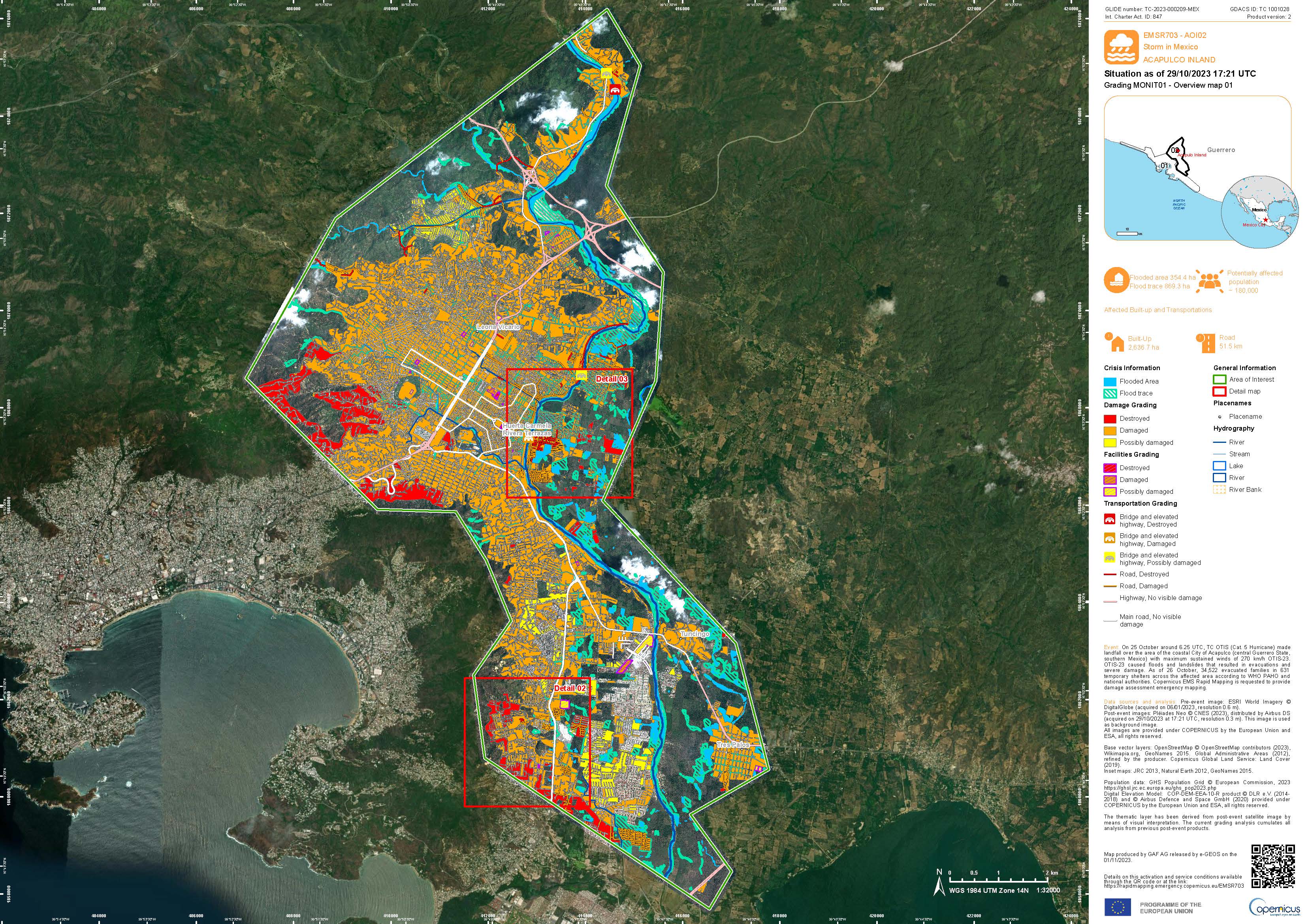
Areas affected by Hurricane Otis in Acapulco, Mexico
Download the Full Report
Direitos autorais: Includes Pleiades Neo material © Airbus DS (2023)
Report produced by the Copernicus Emergency Services
Information about the Product
Adquirida: 29/11/2023
Fonte: Pleiades Neo
Categoria: Grading Map
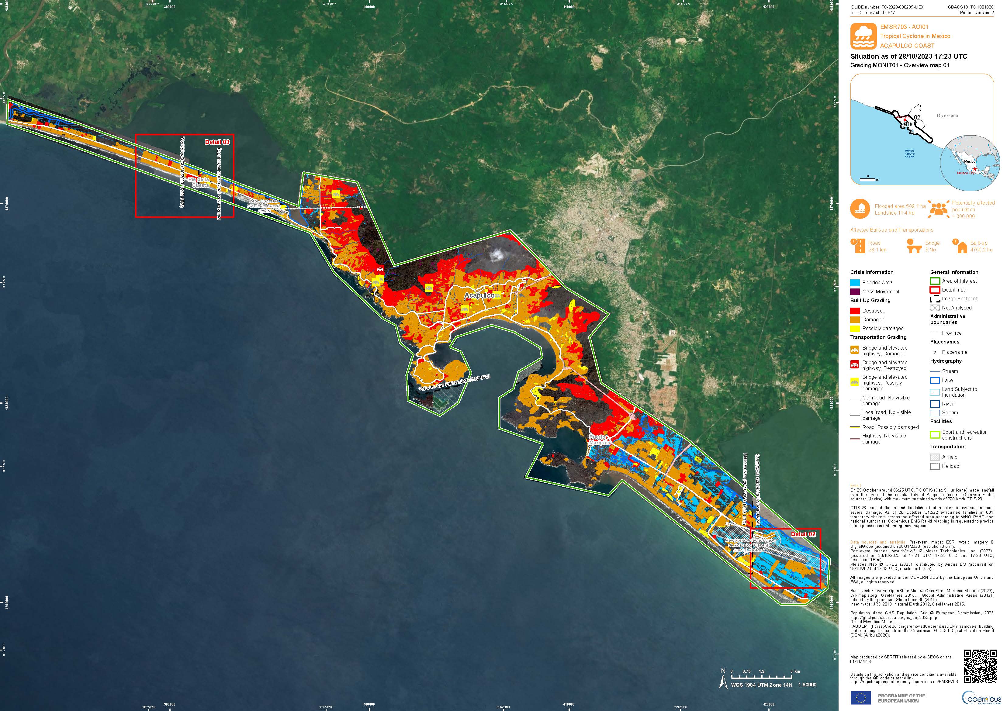
Areas affected by Hurricane Otis on the Acapulco Coast, Mexico
Download the Full Report
Direitos autorais: © (2023) DigitalGlobe, Inc., Longmont CO USA 80503. DigitalGlobe and the DigitalGlobe logos are trademarks of DigitalGlobe, Inc. The use and/or dissemination of this data and/or of any product in any way derived there from are restricted. Unauthorized use and/or dissemination is prohibited.
Report produced by the Copernicus Emergency Service.
Information about the Product
Adquirida: 28/10/2023
Fonte: WorldView-3
Categoria: Grading Map
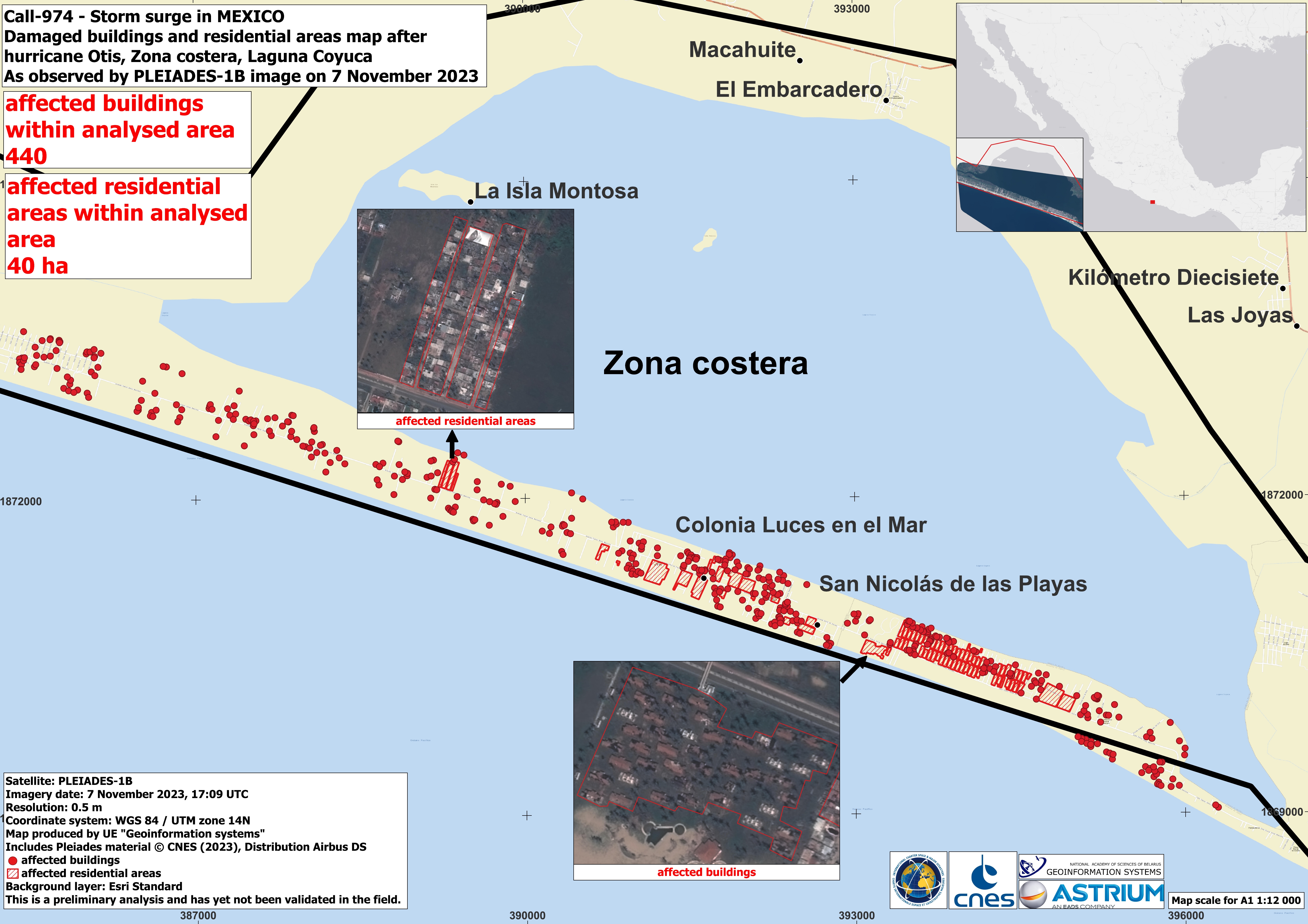
A Map of Damaged Buildings and Residential Areas in Zona Costera, Laguna Coyuca, Mexico
Direitos autorais: Includes Pleiades material © CNES (2023), Distribution Airbus DS.
Map produced by UE Geoinformation Systems
Information about the Product
Adquirida: 07/11/2023
Fonte: Pleiades
Categoria: Grading Map
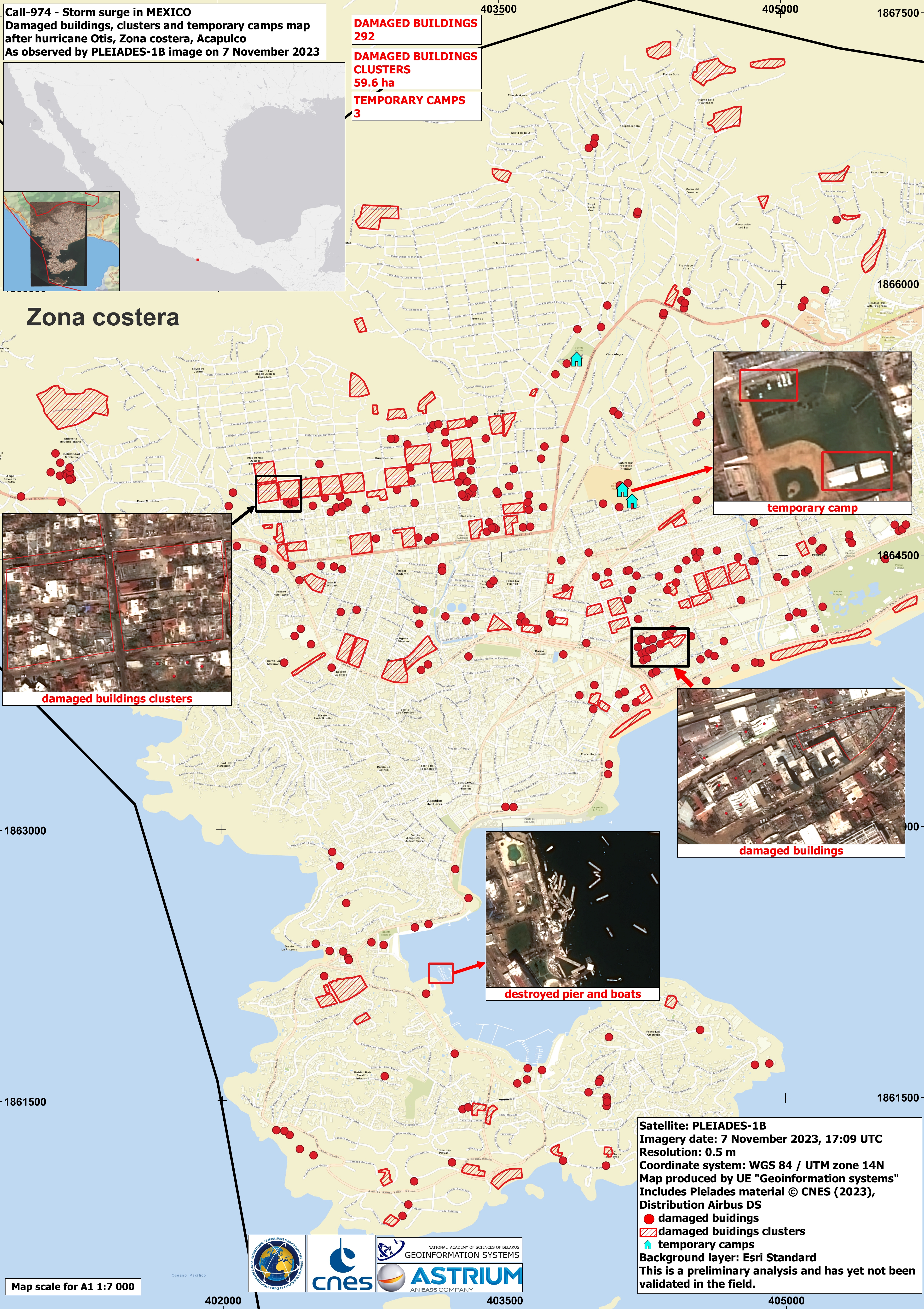
A Map of Damaged Buildings and Temporary Shelters in Zona Costera, Acapulco, Mexico
Direitos autorais: Includes Pleiades material © CNES (2023), Distribution Airbus DS.
Map produced by UE Geoinformation Systems
Information about the Product
Adquirida: 07/11/2023
Fonte: Pleiades
Categoria: Grading Map
Damaged Buildings after Hurricane Otis in the Western part of Zona Costera, Mexico
Direitos autorais: Includes Pleiades material © CNES (2023), Distribution Airbus DS.
Map produced by UE Geoinformation Systems
Information about the Product
Adquirida: 01/11/2023
Fonte: Pleiades
Categoria: Grading Map
Regional Map of Flooding in the Acapulco region, Mexico
Direitos autorais: RADARSAT Constellation Mission Imagery © Government of Canada (2023) - RADARSAT is an official mark of the Canadian Space Agency.
Map produced by the Canadian Space Agency (CSA)
Information about the Product
Adquirida: 27/10/2023
Fonte: RCM
Categoria: Delineation Map
Preliminary Satellite Derived Damage Assessment of Acapulco town, Acapulco de Juárez Municipality, Guerrero State, Mexico
Download the Full Report
Direitos autorais: WorldView-2 © (2023) DigitalGlobe, Inc., Longmont CO USA 80503. DigitalGlobe and the DigitalGlobe logos are trademarks of DigitalGlobe, Inc. The use and/or dissemination of this data and/or of any product in any way derived there from are restricted. Unauthorized use and/or dissemination is prohibited.
GeoEye-1 © 2004 GeoEye NextView License.
Report produced by UNITAR/UNOSAT
Information about the Product
Adquirida: WorldView-2: 12/10/2023 and 31/10/2023
GeoEye-1: 06/01/2023
Fonte: WorldView-2 and GeoEye-1
Categoria: Reference Map
Preliminary satellite-derived damage assessment, Guerrero State, Mexico
Download the Full Report
Direitos autorais: Includes Pleiades material © CNES (2023), Distribution Airbus DS.
WorldView-3 © (2023) DigitalGlobe, Inc., Longmont CO USA 80503. DigitalGlobe and the DigitalGlobe logos are trademarks of DigitalGlobe, Inc. The use and/or dissemination of this data and/or of any product in any way derived there from are restricted. Unauthorized use and/or dissemination is prohibited.
Report produced by UNOSAT/UNITAR
Information about the Product
Adquirida: Pleiades: 29/10/2023 and 30/10/2023
WorldView-3: 27/10/2023
Fonte: Pleiades and WorldView-3
Categoria: Reference Map
 Voltar ao arquivo completo da Ativação

