Charter activations
Landslide in Colombia
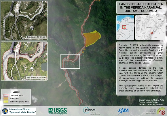
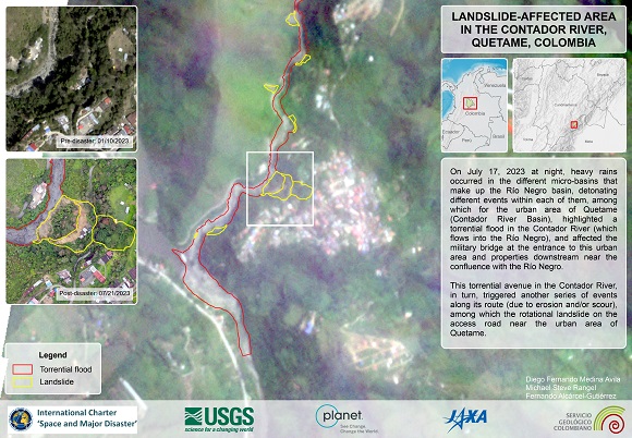
A landslide caused by heavy rains in a mountainous region of central Colombia killed at least 12 people and destroyed several houses. The disaster took place in Quetame, a municipality southeast of the capital, Bogotá.
Major transport links have been badly affected such as a national highway connecting the capital Bogota with Villavicencio, the capital of Meta province, an important region for agriculture.
Rescue teams from the Civil Defense, the Red Cross, firefighters and members of the military continue to search for the missing between the mud and rubble.
Landslides are common in Colombia due to the mountainous terrain and frequent heavy rains.
| Tipo de evento: | landslide |
| Local do evento: | Colombia |
| Data da Ativação da Carta: | 2023-07-21 |
| Tempo de Ativação da Carta: | 16:26 |
| Zona de Tempo da Ativação da Carta: | UTC-05:00 |
| Requisitante da Carta: | National Unit for Disaster Risk Management (UNGRD) |
| ID da Ativação: | 830 |
| Gerenciamento de projeto: | Javier Soto (UNGRD) |
| act-value-adders: | Carlos Laverde (Servicio Geologico Colombiano) CNRS EOST |
Products

Areas affected by Flooding of the Naranjal Stream and Landslides in the Vereda Naranjal, Quetame in Colombia
Direitos autorais: ALOS-1 © JAXA, METI (2006)
WorldView-3 © (2023) DigitalGlobe, Inc., Longmont CO USA 80503. DigitalGlobe and the DigitalGlobe logos are trademarks of DigitalGlobe, Inc. The use and/or dissemination of this data and/or of any product in any way derived there from are restricted. Unauthorized use and/or dissemination is prohibited.
PlanetScope © Planet Labs Inc. (2023)
Map produced by Servicio Geológico Colombiano
Information about the Product
Adquirida: ALOS-1: 22/12/2006
WorldView-3: 10/01/2020
PlanetScope: 26/07/2023
Fonte: ALOS-1, WorldView-3 and PlanetScope
Categoria: Delineation Map

Areas affected by Flooding and Landslides near the Contador River in Quetame, Colombia
Direitos autorais: ALOS-1 © JAXA, METI (2006)
WorldView-3 © (2023) DigitalGlobe, Inc., Longmont CO USA 80503. DigitalGlobe and the DigitalGlobe logos are trademarks of DigitalGlobe, Inc. The use and/or dissemination of this data and/or of any product in any way derived there from are restricted. Unauthorized use and/or dissemination is prohibited.
PlanetScope © Planet Labs Inc. (2023)
Map produced by Servicio Geológico Colombiano
Information about the Product
Adquirida: ALOS-1: 21/12/2006
WorldView-3: 10/01/2020
PlanetScope: 25/07/2023
Fonte: ALOS-1, WorldView-3 and PlanetScope
Categoria: Delineation Map
 Voltar ao arquivo completo da Ativação

 English
 Spanish
 French
 Chinese
 Russian
 Portuguese


