 English
 Spanish
 French
 Chinese
 Russian
 Portuguese
 Latest Activation
Charter activations
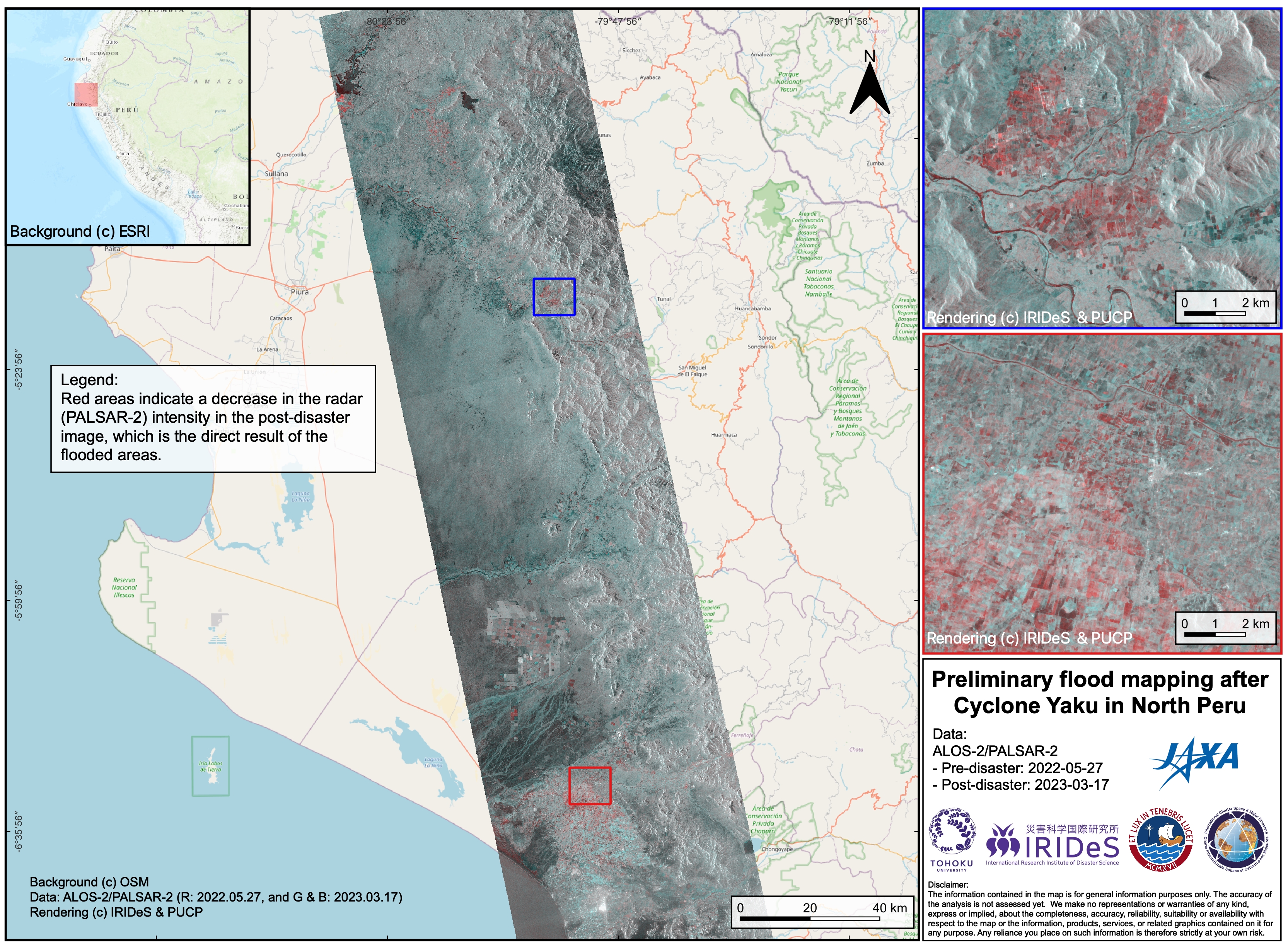
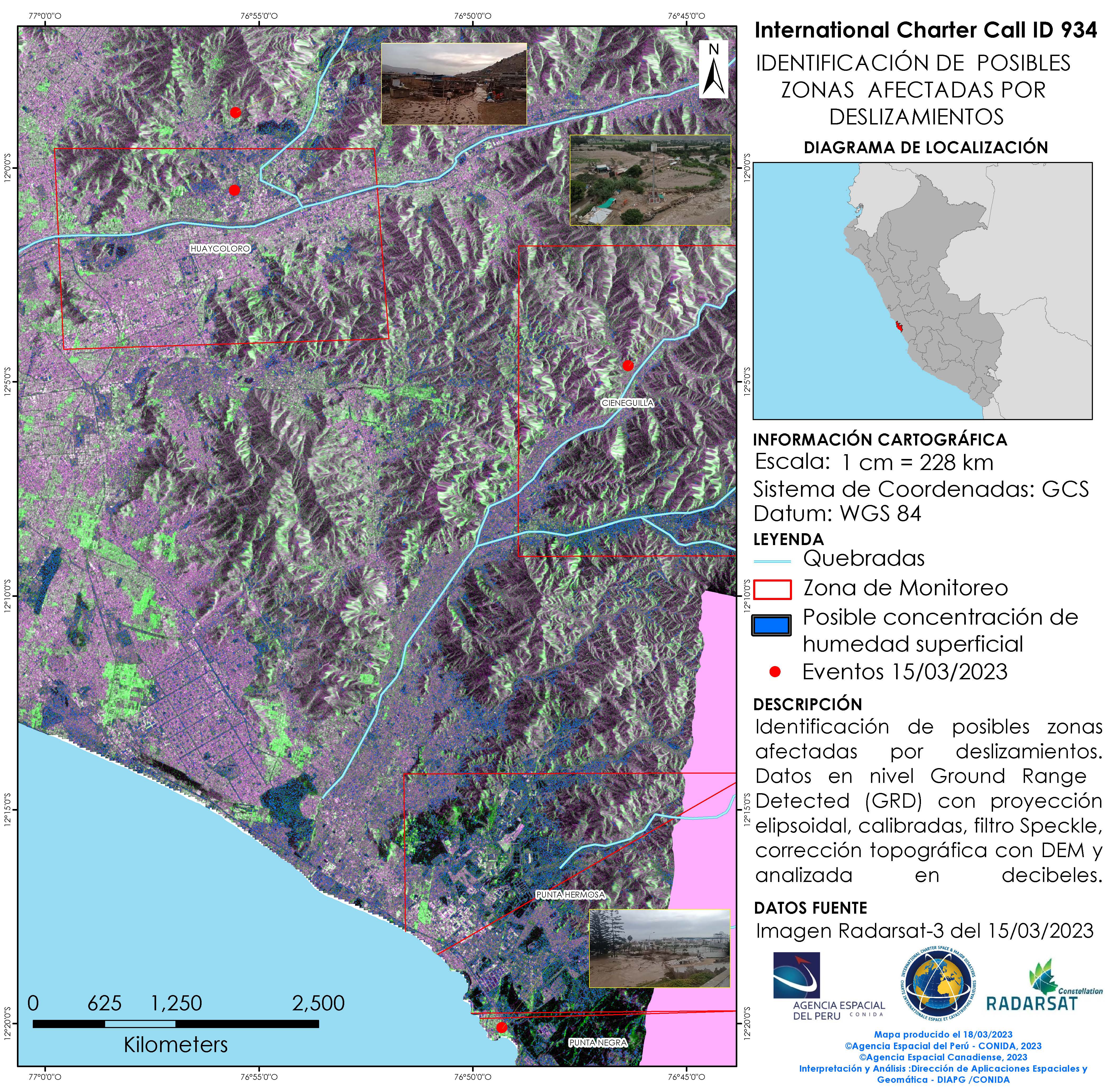
Cyclone Yaku in Peru
Powerful Cyclone Yaku has unleashed torrents of rain on Peru's northern region in recent days, burying homes and cars in mud and leading to the deaths of at least six people.
A Landslide in Huancabamba has blocked it's main road, leading to 70,000 inhabitants being left isolated.
The government has declared a state of emergency in 400 districts as it seeks to bring relief to regions including Lambayeque, Piura and Tumbes. Nearly 60 people have died since the start of the rainy season, according to the National Institute of Civil Defense (INDECI).
| Local do evento: | Peru |
| Data da Ativação da Carta: | 2023-03-13 |
| Tempo de Ativação da Carta: | 21:31 |
| Zona de Tempo da Ativação da Carta: | UTC-05:00 |
| Requisitante da Carta: | USGS on behalf of Instituto Nacional de Defensa Civil (INDECI) and Comisión Nacional de Investigación y Desarrollo Aeroespacial (CONIDA) |
| ID da Ativação: | 811 |
| Gerenciamento de projeto: | José Pasapera (CONIDA) |
| act-value-adders: | Bruno ADRIANO (Tohoku University) |
Products
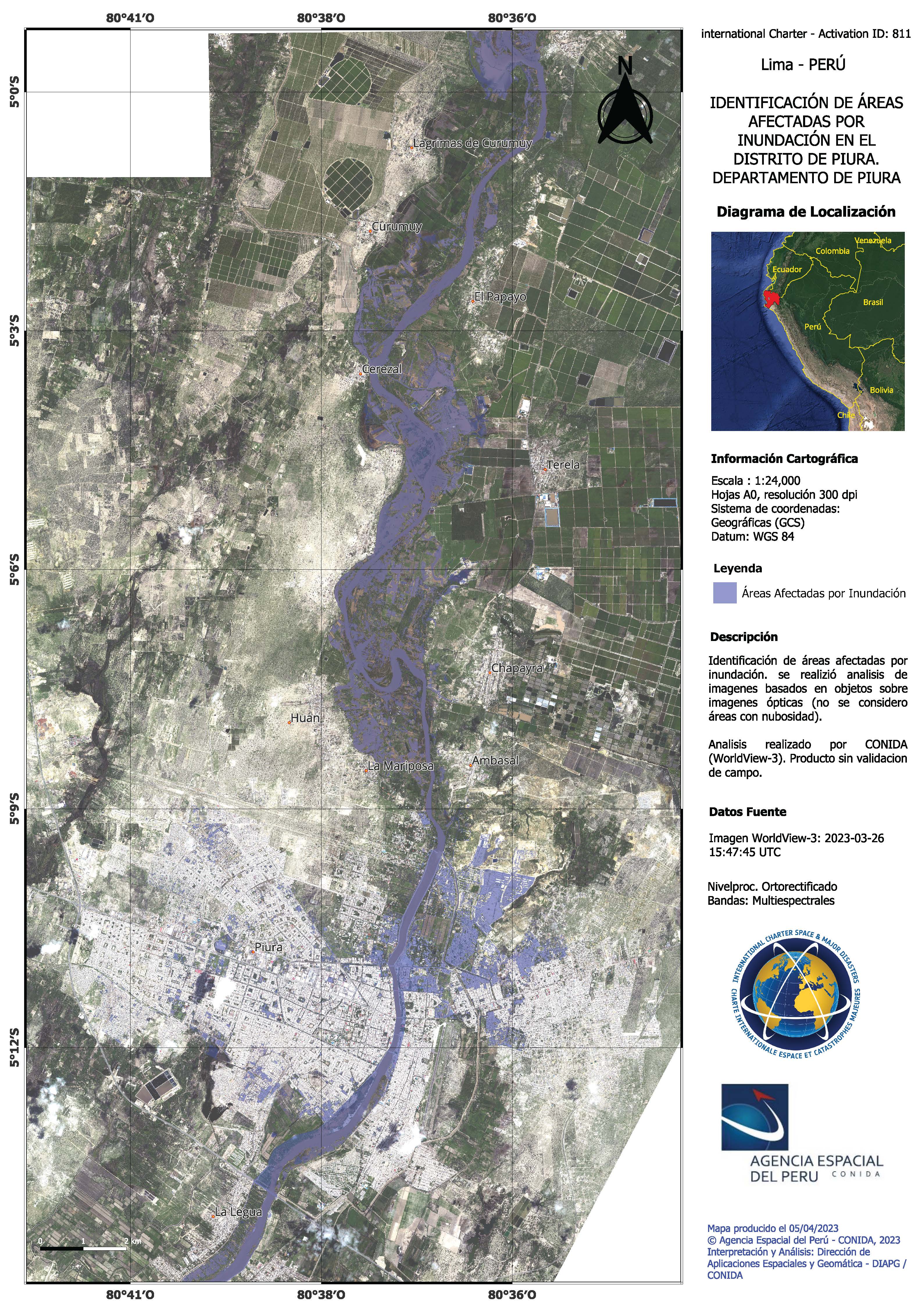
Identification of areas affected by flooding in the district of Huan, Piura - Peru
Direitos autorais: © (2023) DigitalGlobe, Inc., Longmont CO USA 80503. DigitalGlobe and the DigitalGlobe logos are trademarks of DigitalGlobe, Inc. The use and/or dissemination of this data and/or of any product in any way derived there from are restricted. Unauthorized use and/or dissemination is prohibited.
Map produced by the Space Agency of Peru - CONIDA
Information about the Product
Adquirida: 29/03/2023
Fonte: WorldView-2
Categoria: Delineation Map
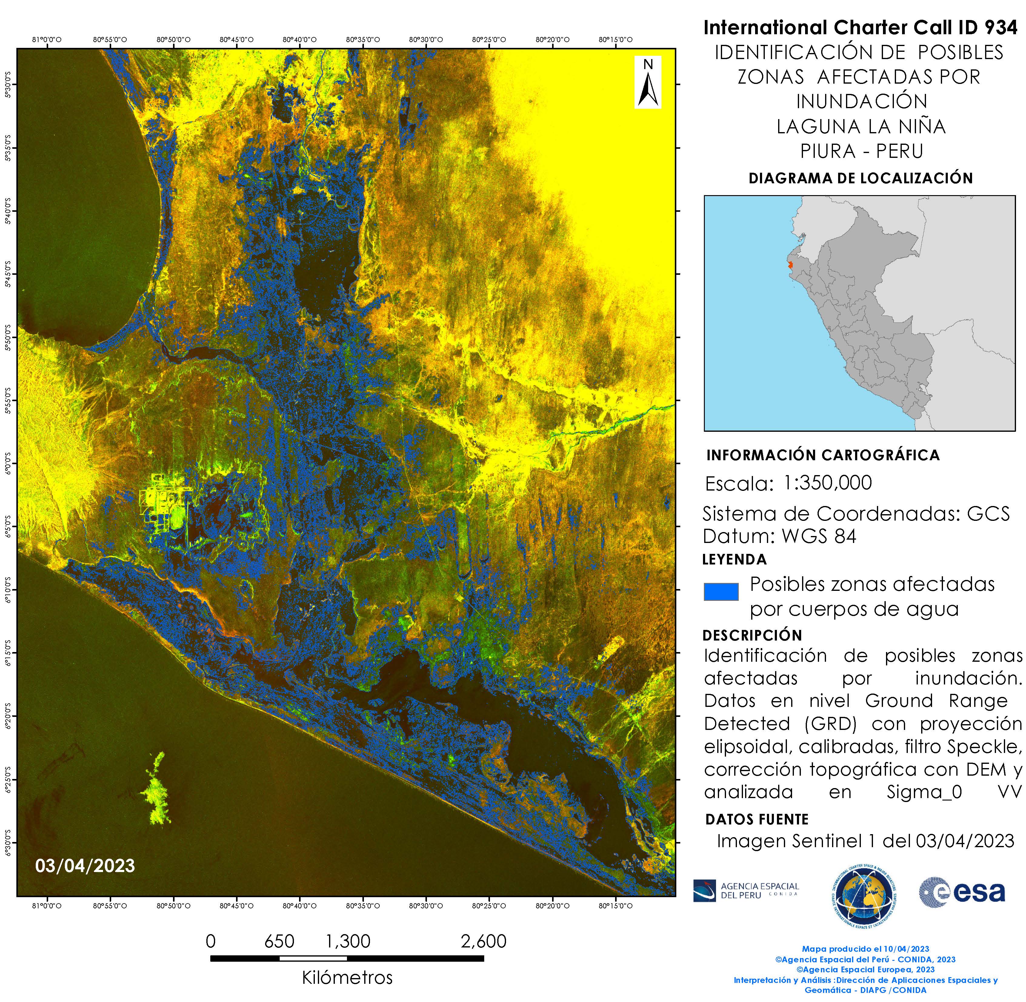
Identification of probable areas affected by the flooding of the La Niña lagoon, Piura - Peru
Direitos autorais: Contains modified Copernicus Sentinel data (2023)
Map produced by the Space Agency of Peru - CONIDA
Information about the Product
Adquirida: 15/04/2023
Fonte: Sentinel-1
Categoria: Delineation Map
Identification of probable areas affected by flooding in San Ramon Tizal y Chutuque, Piura - Peru
Direitos autorais: © DLR e.V. (2023), Distribution Airbus DS Geo GmbH
Map produced by the Space Agency of Peru - CONIDA
Information about the Product
Adquirida: 18/04/2023
Fonte: TerraSAR-X
Categoria: Delineation Map
Identification of areas potentially affected by rains and river overflows in the Corrales and Tumbes district.
Direitos autorais: © (2023) DigitalGlobe, Inc., Longmont CO USA 80503. DigitalGlobe and the DigitalGlobe logos are trademarks of DigitalGlobe, Inc. The use and/or dissemination of this data and/or of any product in any way derived there from are restricted. Unauthorized use and/or dissemination is prohibited
Map produced by the Space Agency of Peru - CONIDA
Information about the Product
Adquirida: 17/04/2023
Fonte: WorldView-3
Categoria: Delineation Map
Identification of Probable Flooded Areas in the City of Chiclayo, Lambayeque, Peru
Direitos autorais: © (2023) DigitalGlobe, Inc., Longmont CO USA 80503. DigitalGlobe and the DigitalGlobe logos are trademarks of DigitalGlobe, Inc. The use and/or dissemination of this data and/or of any product in any way derived there from are restricted. Unauthorized use and/or dissemination is prohibited.
Map produced by CONIDA - The Space Agency of Peru
Information about the Product
Adquirida: 02/04/2023
Fonte: WorldView-3
Categoria: Delineation Map

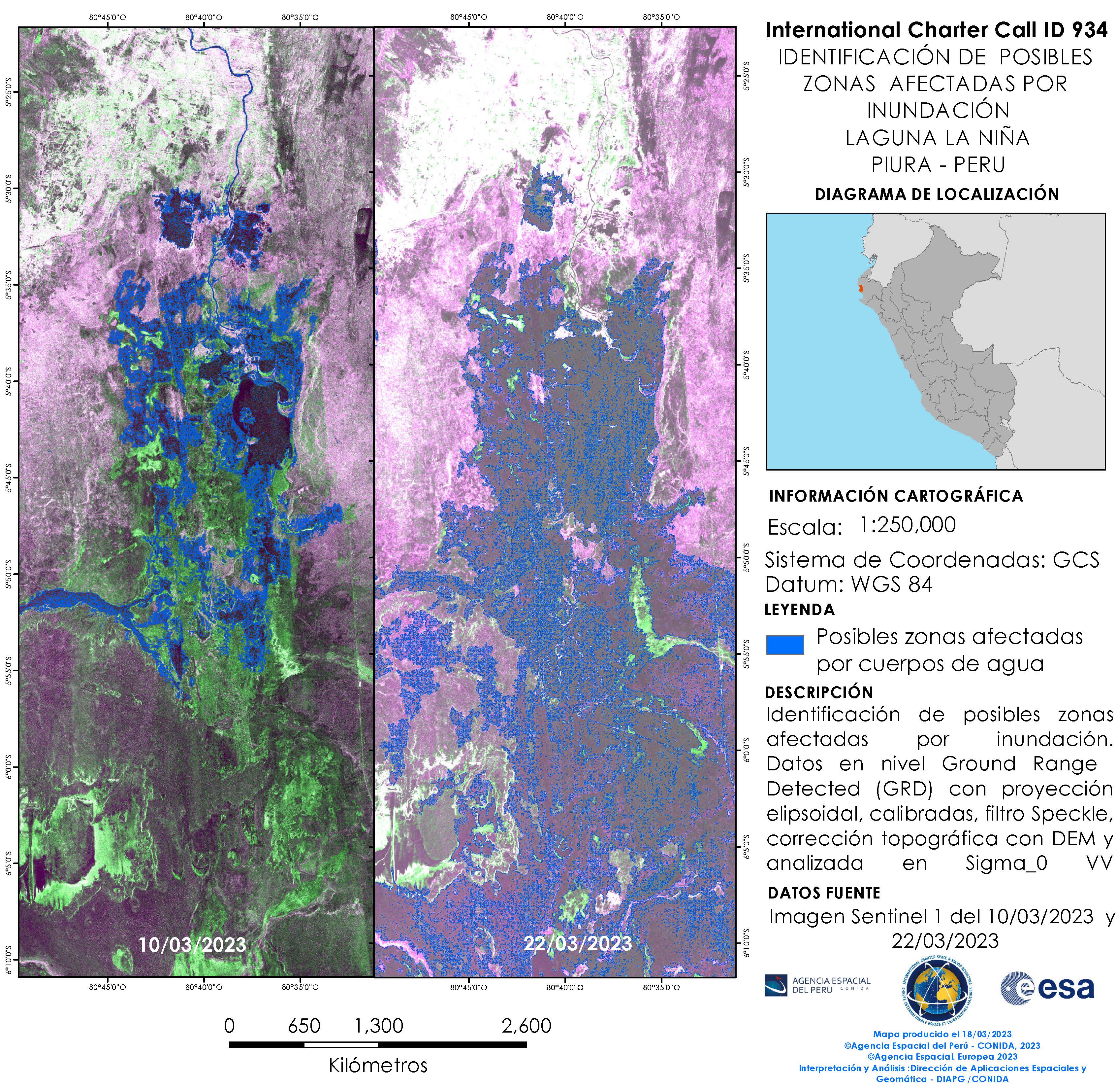
Identification of possible zones affected by the flooding of Laguna La Niña, Piura in Peru
Direitos autorais: Contains modified Copernicus Sentinel data (2023)
Map produced by CONIDA - The Space Agency of Peru
Information about the Product
Adquirida: 10/03/2023, 22/03/2023
Fonte: Sentinel-1
Categoria: Delineation Map
Identification of possible areas affected by flooding in the city of Piura - Peru
Direitos autorais: © (2023) DigitalGlobe, Inc., Longmont CO USA 80503. DigitalGlobe and the DigitalGlobe logos are trademarks of DigitalGlobe, Inc. The use and/or dissemination of this data and/or of any product in any way derived there from are restricted. Unauthorized use and/or dissemination is prohibited
Map produced by the Space Agency of Peru - CONIDA
Information about the Product
Adquirida: 26/03/2023
Fonte: WorldView-3
Categoria: Delineation Map
Identification of possible areas affected by flooding in Samanco, Ancash - Peru
Direitos autorais: © (2023) DigitalGlobe, Inc., Longmont CO USA 80503. DigitalGlobe and the DigitalGlobe logos are trademarks of DigitalGlobe, Inc. The use and/or dissemination of this data and/or of any product in any way derived there from are restricted. Unauthorized use and/or dissemination is prohibited.
Map produced by the Space Agency of Peru - CONIDA
Information about the Product
Adquirida: 19/03/2023
Fonte: WorldView-3
Categoria: Delineation Map
Identification of possible flooded areas in the city of Chiclayo - Lambayeque
Direitos autorais: © (2023) DigitalGlobe, Inc., Longmont CO USA 80503. DigitalGlobe and the DigitalGlobe logos are trademarks of DigitalGlobe, Inc. The use and/or dissemination of this data and/or of any product in any way derived there from are restricted. Unauthorized use and/or dissemination is prohibited.
Map produced by the Space Agency of Peru - CONIDA
Information about the Product
Adquirida: WorldView-2: 29/03/2023
WorldView-3: 26/03/2023
Fonte: WorldView-2 and WorldView-3
Categoria: Delineation Map
Identification of flooded areas in Changoyape - Lambayeque
Direitos autorais: © Agencia Espacial del Peru - CONIDA
RADARSAT Constellation Mission Imagery © Government of Canada (2023) - RADARSAT is an official mark of the Canadian Space Agency
Map produced by Space Agency of Peru - CONIDA
Information about the Product
Adquirida: PeruSAT-1: 15/03/2023
RCM: 16/03/2023
Fonte: PeruSAT / RCM
Categoria: Delineation Map
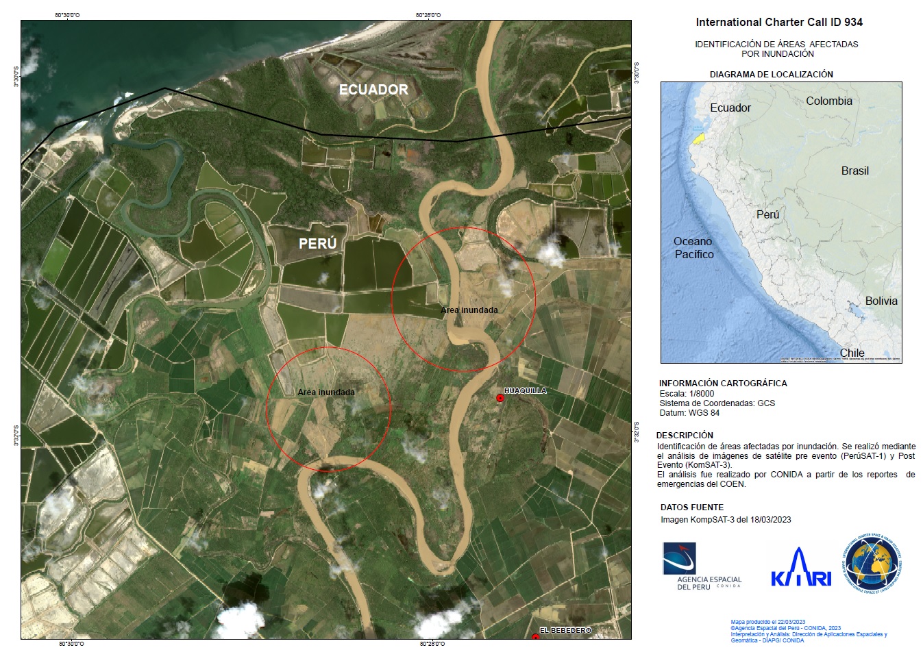
Areas affected by flood in Lima, Peru
Direitos autorais: RADARSAT Constellation Mission Imagery © Government of Canada (2023) - RADARSAT is an official mark of the Canadian Space Agency.
Map produced by Space Agency of Peru - CONIDA
Information about the Product
Adquirida: 15/03/2023
Fonte: RCM
Categoria: Delineation Map
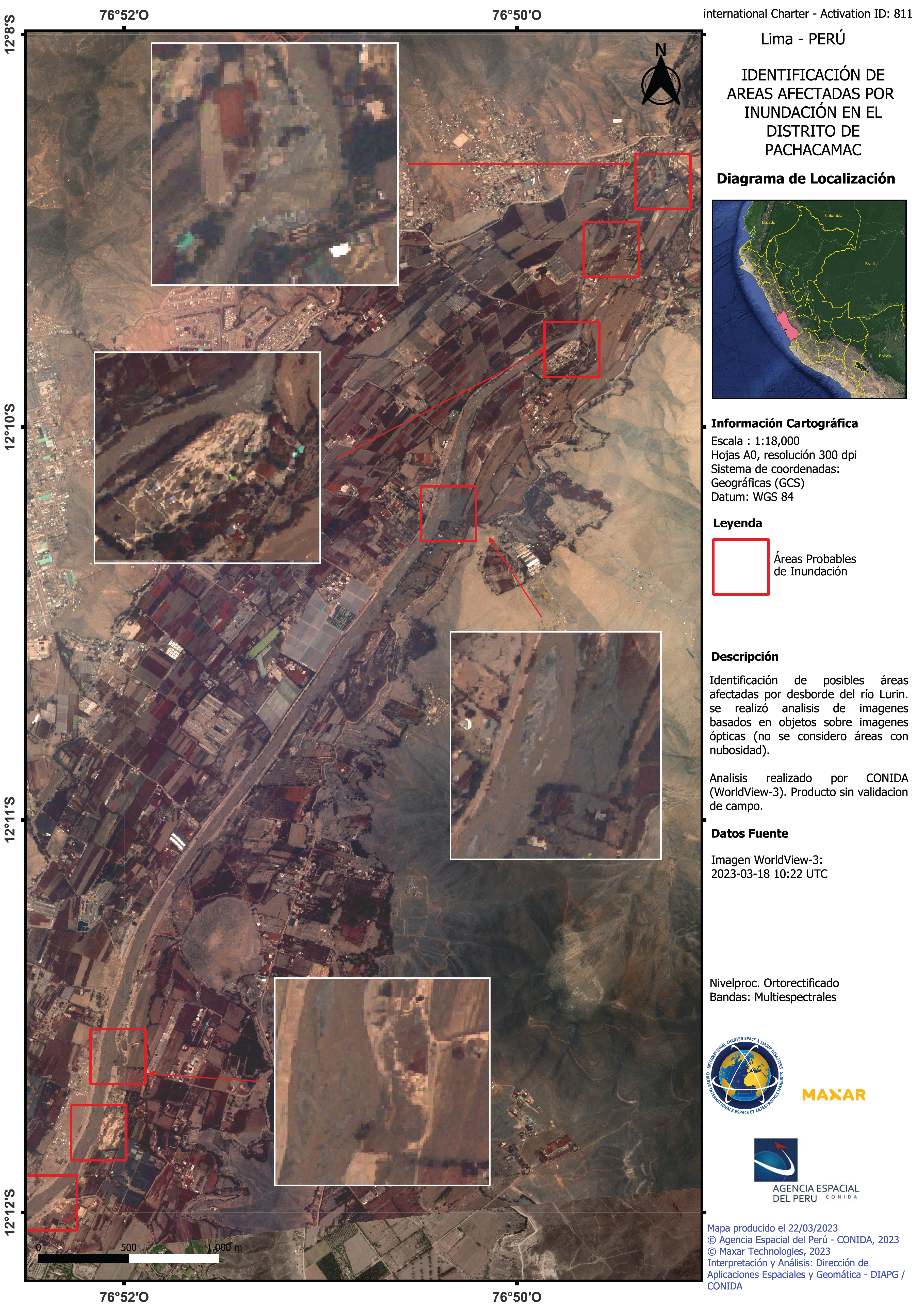
Areas affected by flood in Pachacamac, Lima
Direitos autorais: © (2023) DigitalGlobe, Inc., Longmont CO USA 80503. DigitalGlobe and the DigitalGlobe logos are trademarks of DigitalGlobe, Inc. The use and/or dissemination of this data and/or of any product in any way derived there from are restricted. Unauthorized use and/or dissemination is prohibited.
Map produced by Space Agency of Peru - CONIDA
Information about the Product
Adquirida: 18/03/2023
Fonte: WorldView-3
Categoria: Delineation Map
 Voltar ao arquivo completo da Ativação

