 English
 Spanish
 French
 Chinese
 Russian
 Portuguese
 Latest Activation
Charter activations
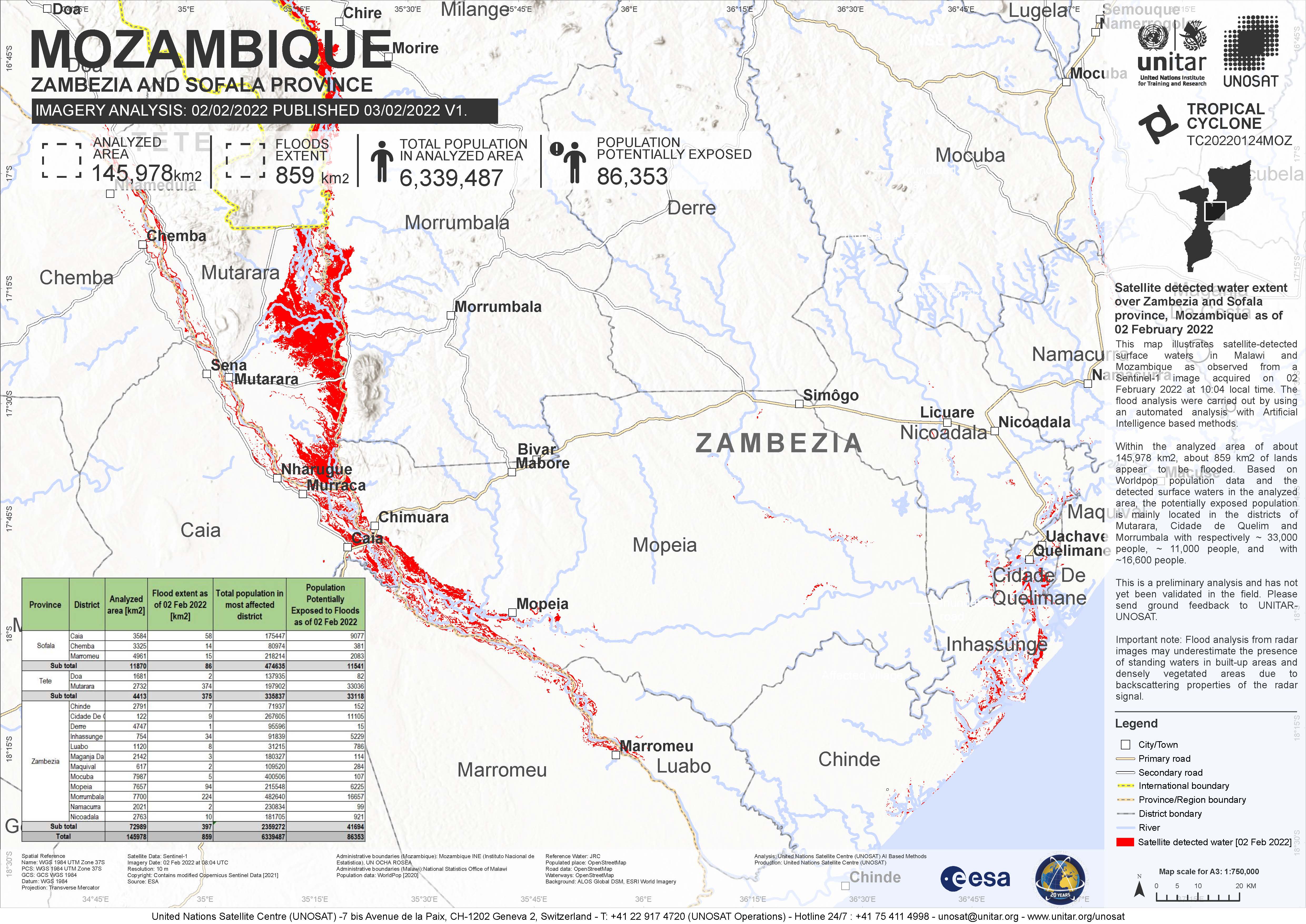
Tropical storm Ana in Mozambique
Tropical storm Ana has killed at least eight people in Mozambique after making landfall on 24 January, bringing heavy rains and strong winds.
Ana is reported to have affected thousands of people, causing damage to homes and other infrastructure.
The storm reached Mozambique a day after passing over Madagascar. Ana gained strength as it traversed the channel, forming into a Tropical Storm before it made landfall.
| Tipo de evento: | Ocean Storm |
| Local do evento: | Mozambique |
| Data da Ativação da Carta: | 2022-01-25 |
| Tempo de Ativação da Carta: | 13:11 |
| Zona de Tempo da Ativação da Carta: | UTC+01:00 |
| Requisitante da Carta: | UNOOSA/UN-SPIDER on behalf of National Institute for Disaster Risk Reduction of Mozambique (INGD) UNOOSA/UN-SPIDER on behalf of Department of Disaster Management Affairs of Malawi |
| ID da Ativação: | 748 |
| Gerenciamento de projeto: | UFSM |
Products


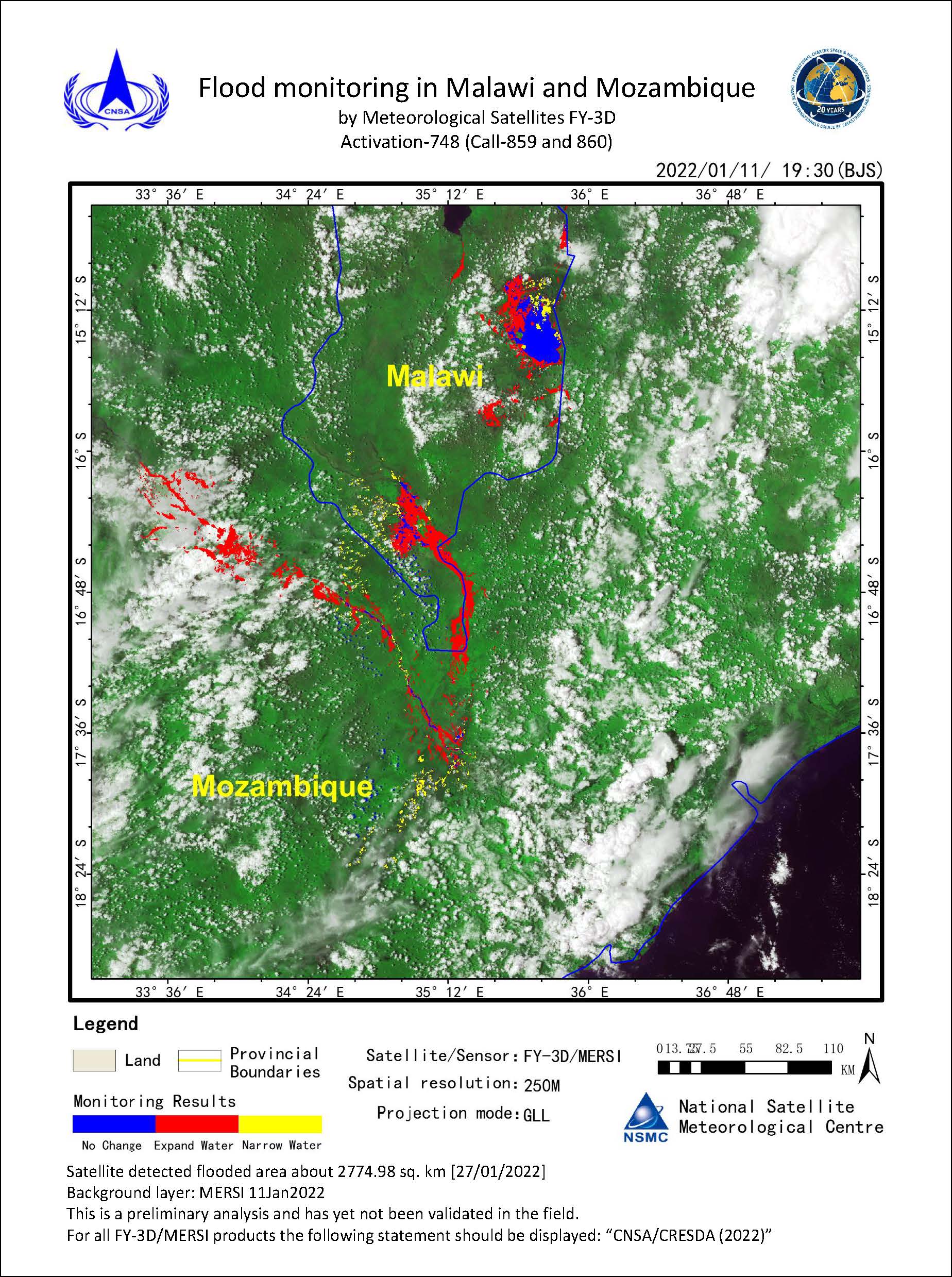
Detected flood in Mozambique and Malawi
Direitos autorais: Contains modified Copernicus Sentinel data (2021)
Map produced by UE Geoinformation Systems
Information about the Product
Adquirida: Sentinel-2: 01/12/2021, 09/02/2022
Sentinel-1 02/02/2022
Fonte: Sentinel-1, Sentinel-2
Categoria: Grading Map
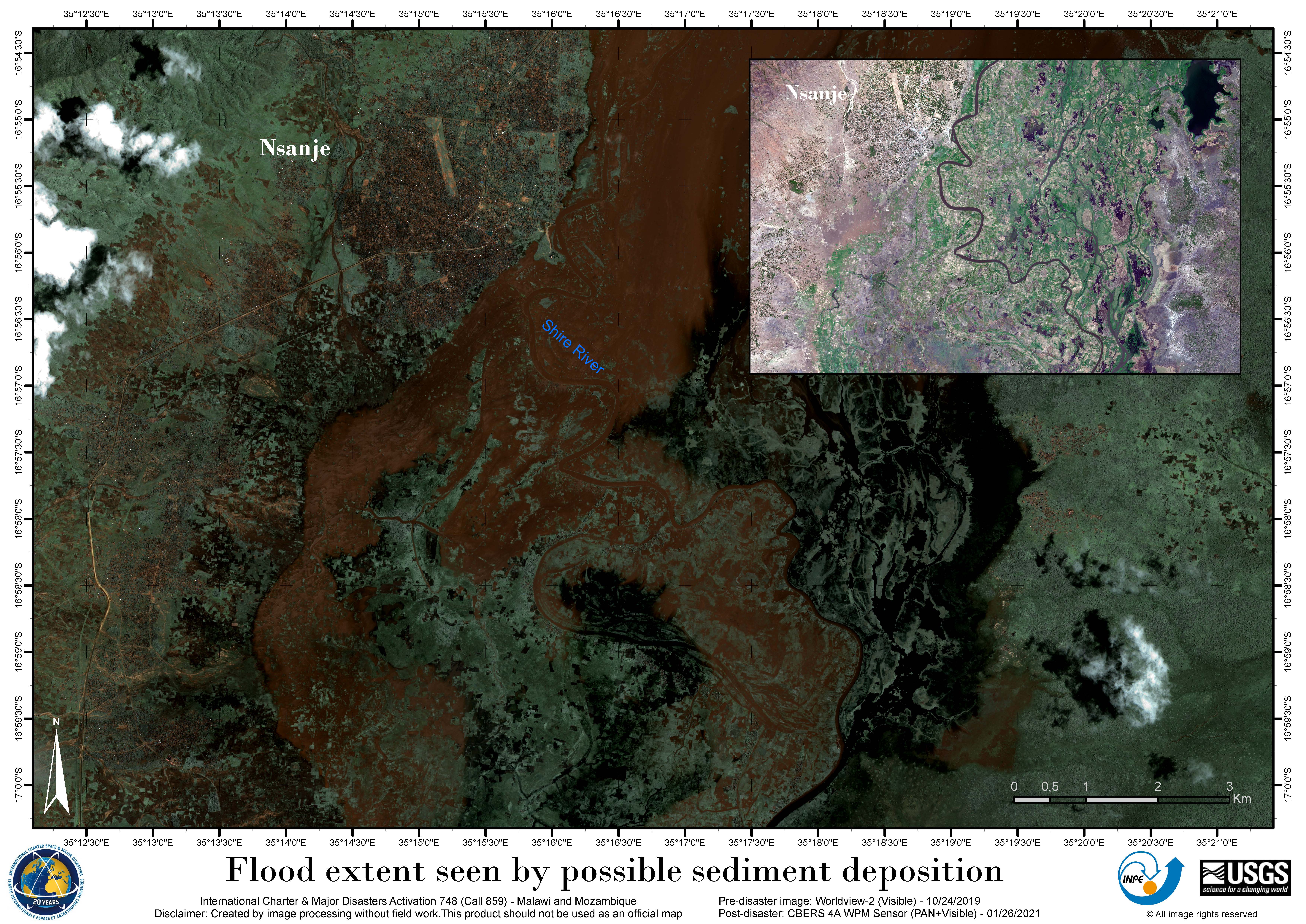
Flood extent seen by possible sediment deposition - Shire River, Mozambique and Malawi
Direitos autorais: WorldView-2 © (2019) DigitalGlobe, Inc., Longmont CO USA 80503. DigitalGlobe and the DigitalGlobe logos are trademarks of DigitalGlobe, Inc. The use and/or dissemination of this data and/or of any product in any way derived there from are restricted. Unauthorized use and/or dissemination is prohibited.
CBERS-4 © INPE (2022)
Map produced by INPE
Information about the Product
Adquirida: WorldView-2: 24/10/2019
CBERS-4: 05/02/2022
Fonte: WorldView-2 / CBERS-4
Categoria: Delineation Map

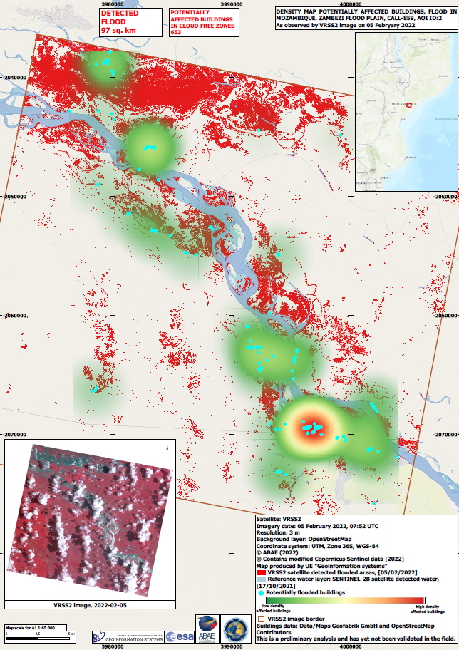


Detected flood in Mozambique, Licungo flood plain
Direitos autorais: © (2022) DigitalGlobe, Inc., Longmont CO USA 80503. DigitalGlobe and the DigitalGlobe logos are trademarks of DigitalGlobe, Inc. The use and/or dissemination of this data and/or of any product in any way derived there from are restricted. Unauthorized use and/or dissemination is prohibited.
Map produced by UE Geoinformation Systems
Information about the Product
Adquirida: 03/02/2022
Fonte: WorldView-2
Categoria: Reference Map
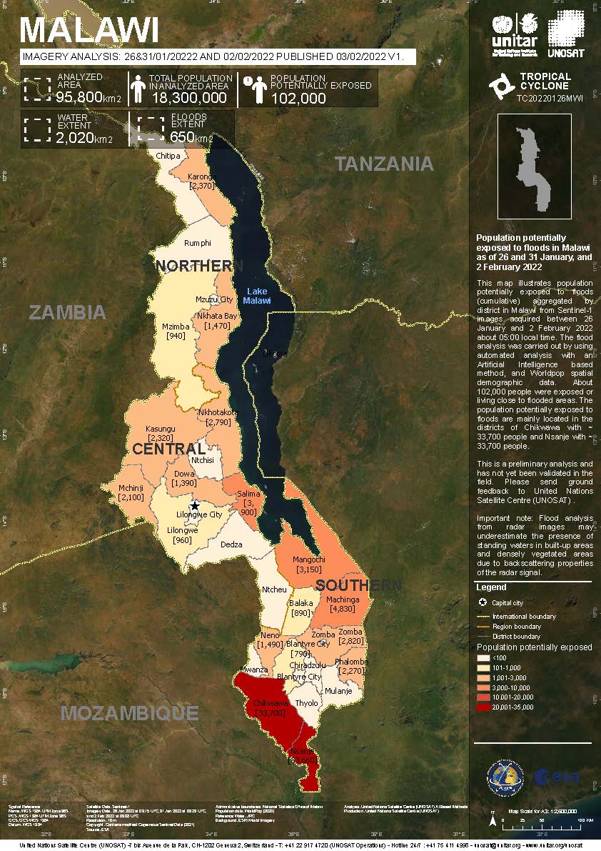
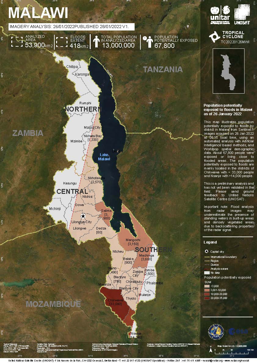
Population potentially exposed to floods in Malawi as of 26 and 31 January, and 2 February 2022
Direitos autorais: Contains modified Copernicus Sentinel data (2022)
Map produced by UNITAR / UNOSAT
Information about the Product
Adquirida: 26/01/2022, 02/02/2022
Fonte: Sentinel-1
Categoria: Delineation Monitoring Maps
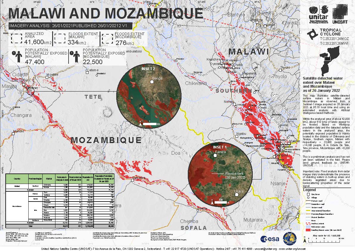
Satellite detected water extents in Malawi as of 26 and 31 January, and 2 February 2022
Direitos autorais: Contains modified Copernicus Sentinel data (2022)
Map produced by UNITAR / UNOSAT
Information about the Product
Adquirida: 26/01/2022, 02/02/2022
Fonte: Sentinel-1
Categoria: Delineation Monitoring Maps

Detected flood in Mozambique and Malawi
Direitos autorais: © DLR e.V. (2022), Distribution Airbus DS Geo GmbH
Contains modified Copernicus Sentinel data (2022)
Map produced by Geoinformation systems
Information about the Product
Adquirida: TerrSAR-X: 31/01/2022
Sentinel-1: 02/02/2022
Fonte: TerrSAR-X, Sentinel-1
Categoria: Delineation Monitoring Maps


Water extends on Zambezi River, pre-event image and post-event image
Direitos autorais: RADARSAT Constellation Mission Imagery © Government of Canada (2022) - RADARSAT is an official mark of the Canadian Space Agency
Contains modified Copernicus Sentinel data (2022)
Map produced by the Federal University of Santa Maria, Brazil
Information about the Product
Adquirida: Sentinel-1: 21/01/2022
RCM: 26/01/2022
Fonte: Sentinel-1, RCM
Categoria: Reference Map
Satellite Detected Water Extent over Zambezi River, Mozambique
Direitos autorais: Contains modified Copernicus Sentinel data (2022)
RADARSAT Constellation Mission Imagery © Government of Canada (2022) - RADARSAT is an official mark of the Canadian Space Agency
Map produced by Federal University of Santa Maria, Brazil
Information about the Product
Adquirida: RCM: 26/01/2022
Sentinel-1: 21/01/2022
Fonte: Sentinel-1, RCM
Categoria: Reference Map

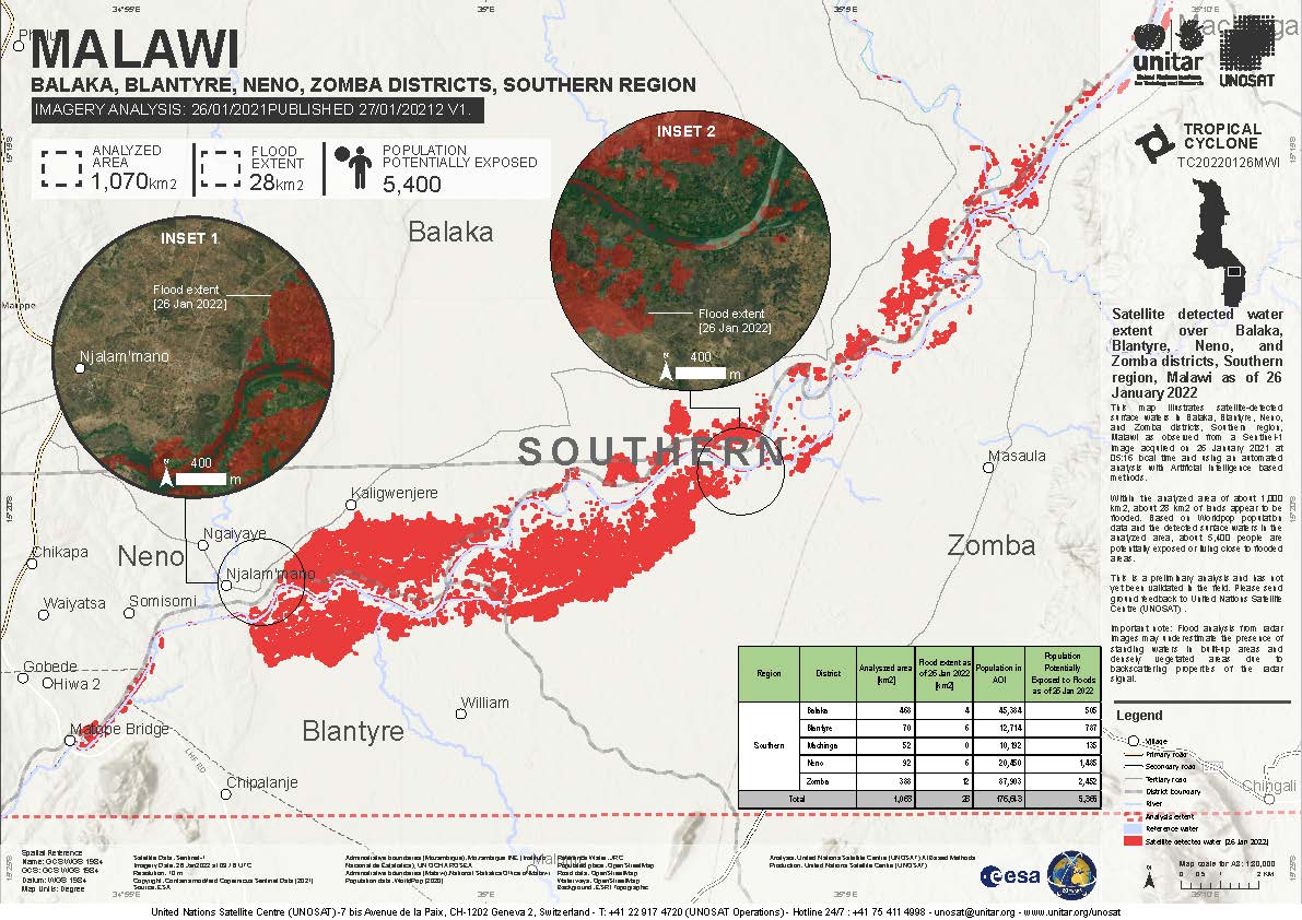
Satellite detected water extent over Balaka, Neno and Zomba districts, Southern Region, Malawi
Direitos autorais: Contains modified Copernicus Sentinel data (2022)
Map produced by UNITAR / UNOSAT
Information about the Product
Adquirida: 26/01/2022
Fonte: Sentinel-1
Categoria: Delineation Monitoring Maps

Flood situation in Mozambique, Zambezi river estuary
Direitos autorais: RADARSAT Constellation Mission Imagery © Government of Canada (2022) - RADARSAT is an official mark of the Canadian Space Agency
Contains modified Copernicus Sentinel data (2022)
Map produced by Geoinformation systems
Information about the Product
Adquirida: Sentinel-2: 09/01/2022
RCM: 26/01/2022
Fonte: RCM, Sentinel-2
Categoria: Reference Map
 Voltar ao arquivo completo da Ativação

