 English
 Spanish
 French
 Chinese
 Russian
 Portuguese
 Latest Activation
Charter activations
Flood in west Africa / Nigeria (Lokoja)
The flash floods in west Africa, reported to be the worst in 50 years, have also affected Koji State in Nigeria. The state has been declared a national disaster area by the federal government, with two million people displaced by the floods and some communities submerged.
The flooding in Koji State has been reported to be at a level not seen in a hundred years and the flood waters have particularly affected Lokoja, the state capital.
Lokoja is located at a confluence between the Niger and Benue Rivers, both of which have flooded. Thousands of people have been stranded on the Abuja-Lokoja-Okene Road, a major transportation route that accounts for 70% of the traffic between the north and south of the country. Parts of the highway have been inundated, further impeding transport.
Further contributing to the flood waters are excess water released from the Lagdo Dam in Cameroon and the Shiroro and Kainji Dams in Nigeria. Construction firms have been called in to assess the situation and provide solutions.
| Tipo de evento: | Flood |
| Local do evento: | West Africa / Nigeria (Lokoja) |
| Data da Ativação da Carta: | 25 September 2012 |
| Requisitante da Carta: | National Emergency Management Agency (NEMA) |
| Gerenciamento de projeto: | Regional Centre for Training in Aerospace Survey |
Products
Flooding of Lokoja and Environs
Total flooded areas: 820 Sq.km
Direitos autorais: RADARSAT-2 Data and Products © MacDonald, Dettwiler and Associates Ltd. (2012) - All Rights Reserved. RADARSAT is an official trademark of the Canadian Space Agency.
Map produced by RECTAS (Regional Centre for Training in Aerospace Survey)
Information about the Product
Adquirida: 29/09/2012
Fonte: RADARSAT-2
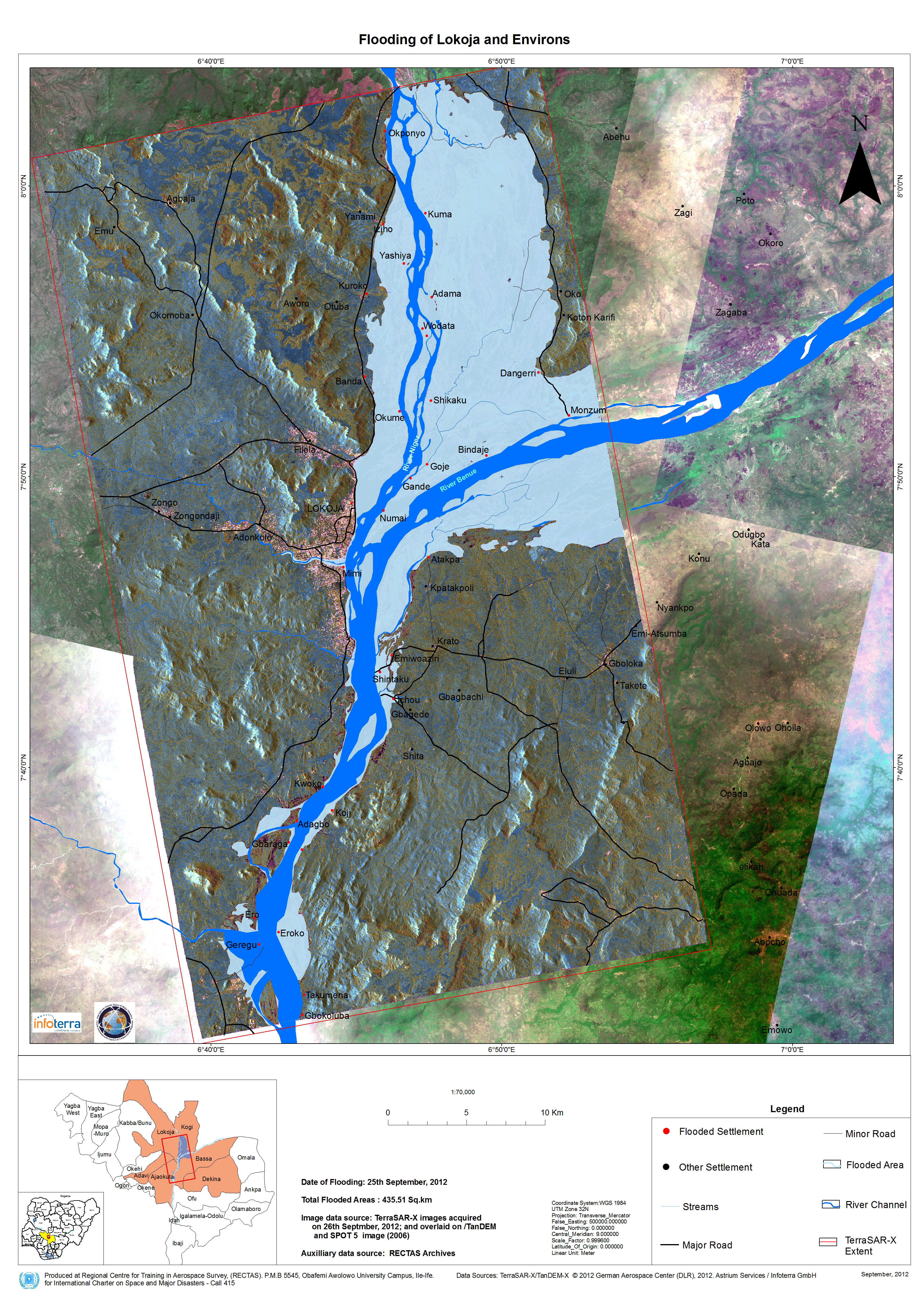
Flooding of Lokoja and Environs
Total flooded areas: 435,51 Sq.km
Direitos autorais: German Aerospace Center (DLR), Astrium Services / Infoterra GmbH 2012
Map produced by RECTAS (Regional Centre for Training in Aerospace Survey)
Information about the Product
Adquirida: TerraSAR-X/TanDEM-X: 26/09/2012
SPOT: 2006
Fonte: TerraSAR-X / TanDEM-X and SPOT
 Voltar ao arquivo completo da Ativação

