 English
 Spanish
 French
 Chinese
 Russian
 Portuguese
 Latest Activation
Charter activations
Hurricane Beryl in Dominican Republic
Hurricane Beryl passed through Dominican Republic after raging through the Caribbean and southern Mexico. It brought with it strong gusty winds and rough surf waves.
The storm surges left rubbish and debris piled high on beaches, rough waves damaged multiple beachfront shops in Boca Chica.
Flooding was reported in the neighbourhood of Ciudad Nueva, disrupting traffic. Large waves scattered debris on a section of the Las Américas Highway in Santo Domingo.
A landslide destroyed a home in La Zurza. Four homes were destroyed by a storm surge in La Ciénaga, where an additional three homes were damaged.
The hurricane displaced 89 people and cut service to 57 aqueducts.
EUMETSAT case study of Hurricane Beryl
| Tipo de evento: | Flood |
| Local do evento: | Dominican Republic |
| Data da Ativação da Carta: | 2024-07-05 |
| Tempo de Ativação da Carta: | 12:17 |
| Zona de Tempo da Ativação da Carta: | UTC-04:00 |
| Requisitante da Carta: | Comisión Nacional de Emergencias (CNE) |
| ID da Ativação: | 894 |
| Gerenciamento de projeto: | Alexander Ariza (UNSPIDER) |
| act-value-adders: | Mónica Rosendo (ABAE) Lizandra PayeVargas (ABE) |
Products

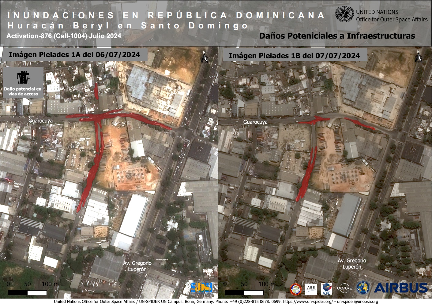
Potential affected areas from Hurricane Beryl - Pre and Post Event in Santo Domingo
Direitos autorais: Includes Pleiades material © CNES (2024), Distribution Airbus DS.
VRSS-2 © ABAE (2024). All Rights Reserved
Map produced by ABAE
Information about the Product
Adquirida: Pleiades : 06/07/2024, 07/07/2024
VRSS-2: 10/07/2024
Fonte: Pleiades / VRSS-2
Categoria: Delineation Monitoring Maps
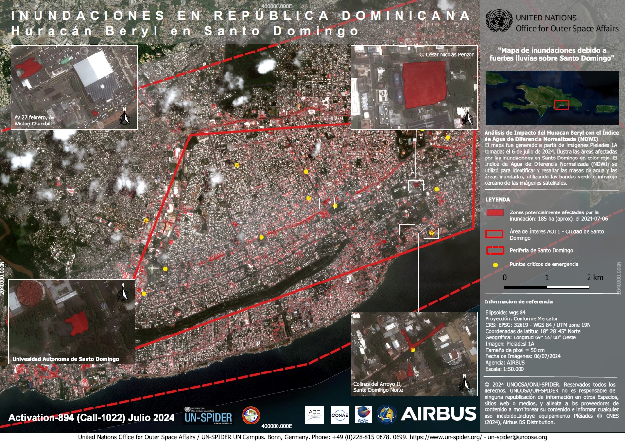
Map of buildings potentially affected by flooding following Hurricane Beryl in Santo Domingo, Dominican Republic
Direitos autorais: Includes Pleiades material © CNES (2024), Distribution Airbus DS.
Map produced by CONAE
Information about the Product
Adquirida: 06/07/2024
Fonte: Pleiades
Categoria: Delineation Map
Map showing river overflow following heavy rains over Santo Domingo, Dominican Republic
Direitos autorais: Includes Pleiades material © CNES (2024), Distribution Airbus DS.
© Planet Labs Inc. (2024
Map produced by UN-SPIDER
Information about the Product
Adquirida: Pleiades : 06/07/2024
PlanetScope : 06/07/2024
Fonte: Pleiades / PlanetScope
Categoria: Grading Map
 Voltar ao arquivo completo da Ativação

