Charter activations
Fire in Canada
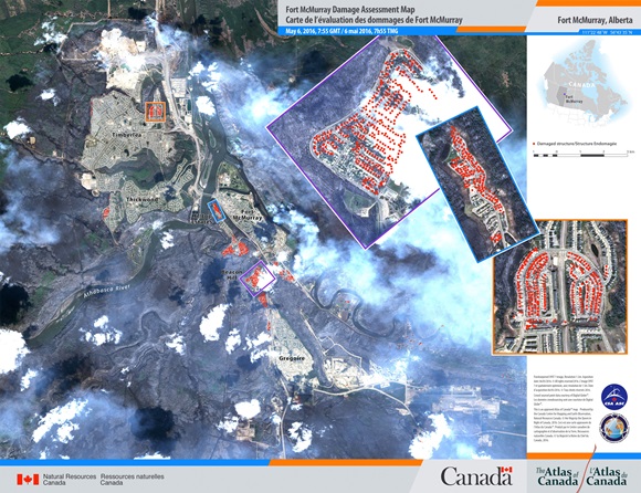
A wildfire in Alberta, Canada, has forced the evacuation of an entire city.
All residents of Fort McMurray, 90,000 people, were given mandatory evacuation orders on 3 May as the fire raged out control in the city.
The fire began on 1 May, and while the exact cause of the fire is unknown, high temperatures and strong winds, pushed it north-east toward Fort McMurray, prompting the evacuation order.
The sheer number of evacuees has quickly filled emergency shelters and camps nearby, forcing some residents to spread farther out to find a refuge.
No fatalities or injuries have been reported as a result of the fire, but the entire neighbourhood of Beacon Hill has been consumed by the fire and a gas station reportedly exploded. While officials made efforts to empty out gas stations during the evacuation, there are concerns that the fires could ignite some fuel left behind.
2,400 buildings, out of 25,000 in the city, have been destroyed, and thanks to the efforts of firefighters 90% of the city has been saved. It is estimated that it could take weeks to make the city safe for people to return to.
Over 500 firefighters, a dozen helicopters and nine air tankers have been working to fight the flames but on 3 May the dry conditions, wind and temperatures of 30°C meant the fire spread quickly and overwhelmed those fighting it. Weather conditions took a more favourable turn on 8 May, with some light rain and a shift in wind, reducing the speed the fire could spread. Nevertheless, the fire covered an area of 1,610 square kilometres as of 8 May.
Related News and Resources
- Wildfire in Fort McMurray - NASA Earth Observatory
- Fort McMurray fire glows from space - NOAA Environmental Visualization Laboratory
- Fires continue in Fort McMurray - NASA Earth Observatory
- Canadian smoke moves toward the North Atlantic - EUMETSAT
- Fort McMurray wildfire continues to burn - NASA
- Devastating fire in Canada - CNES
- ALOS-2/PALSAR-2 observation results on wildfire in Canada - ALOS-2 JAXA
- Fort McMurray burn scar - NASA Earth Observatory
- Canadian fires tracked by satellites - ESA
- Fort McMurray fires - ESA
- Clear skies give way to Fort McMurray blaze - NASA
| Tipo de evento: | Fire |
| Local do evento: | Alberta, Canada |
| Data da Ativação da Carta: | 4 May 2016 |
| Tempo de Ativação da Carta: | 01:14:00 |
| Zona de Tempo da Ativação da Carta: | UTC+05:00 |
| Requisitante da Carta: | GOC Public Safety Canada |
| ID da Ativação: | 488 |
| Gerenciamento de projeto: | Canadian Space Agency (CSA) |
Products
 Voltar ao arquivo completo da Ativação

 English
 Spanish
 French
 Chinese
 Russian
 Portuguese


