Charter activations
Earthquake in Vanuatu
A powerful 7.3 magnitude earthquake struck near Port Vila, the largest city on the group of 80 South Pacific islands that make up Vanuatu, causing landslides, building collapses (including a complex housing several foreign embassies, including the US, British, French, and New Zealand), and power outages.
The earthquake's epicentre was 30km west of the capital and at a depth of 57.1km, according to the reports.
The full extent of the damage is unclear, but there are reports of at least one death and multiple injuries.
Related Resources:
Web map for earthquake in Vanuatu
Sentinel Asia activation for earthquake in Vanuatu| Tipo de evento: | Earthquake |
| Local do evento: | Vanuatu |
| Data da Ativação da Carta: | 2024-12-17 |
| Tempo de Ativação da Carta: | 16:53 |
| Zona de Tempo da Ativação da Carta: | UTC+07:00 |
| Requisitante da Carta: | UNOSAT on behalf of United Nations Office for the Coordination of Humanitarian Affairs (OCHA) Centre Opérationnel de Gestion Interministérielle des Crises (COGIC) |
| ID da Ativação: | 938 |
| Gerenciamento de projeto: | Suwanan Sateiandee (UNOSAT) |
| act-value-adders: | Nic Donnelly (LINZ) GNS Science Fire and Emergency New Zealand Alec Zoeller (GNS Science) Katie Jones (GNS Science) Jaz Hamilton (Fire and Emergency New Zealand) |
Products

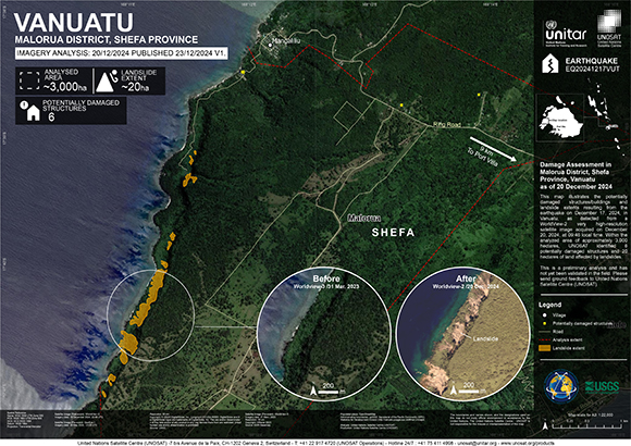
Damage Assessment in Malorua District, Shefa Province, Vanuatu
Direitos autorais: © (2024) DigitalGlobe, Inc., Longmont CO USA 80503. DigitalGlobe and the DigitalGlobe logos are trademarks of DigitalGlobe, Inc. The use and/or dissemination of this data and/or of any product in any way derived there from are restricted. Unauthorized use and/or dissemination is prohibited
© 2004 GeoEye
NextView License
Map produced by USGS
Information about the Product
Adquirida: WorldView-2: 19/12/2024
GeoEye-1: 08/05/2023
Fonte: WorldView-2 / GeoEye-1
Categoria: Grading Map

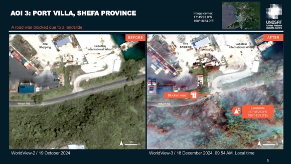
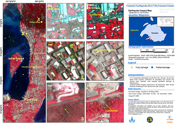
Preliminary Satellite-derived Damage Assessment report of the Vanuatu Earthquake
Download full report
Direitos autorais: © (2024) DigitalGlobe, Inc., Longmont CO USA 80503. DigitalGlobe and the DigitalGlobe logos are trademarks of DigitalGlobe, Inc. The use and/or dissemination of this data and/or of any product in any way derived there from are restricted. Unauthorized use and/or dissemination is prohibited
Includes Pleiades material © CNES (2024), Distribution Airbus DS.
Map produced by UNOSAT / UNITAR
Information about the Product
Adquirida: WorldView-3: 17/12/2024, Pleiades: 19/12/2024, WorldView-2: 19/10/2024
Fonte: WorldView-2, WorldView-3, Pleiades
Categoria: Dossier
 Voltar ao arquivo completo da Ativação

 English
 Spanish
 French
 Chinese
 Russian
 Portuguese


