Charter activations
Las inundaciones en Etiopía
One hundred people have lost their lives, 50,000 cattle are dead and some 105,000 have been left homeless following serious flooding in Ogaden, in the east of Ethiopia. The UN Office for Coordination of Humanitarian Affairs, who released these figures on 03 May 2005, fears that these may be an underestimate, due to the numbers of people that are still being reported missing ten days after the flooding began caused by the rising levels of the Wabe Shebelle River. UNO has also reported that there are difficulties reaching the affected areas. The floods started after two days of torrential rains which started on 23 April 2005. The affected areas are located 700 km east of the capital, Addis Abeba. Land, homes, wells and roads have also been seriously damaged.
| Type of Event: | Inundaciones |
| Location of Event: | Etiopía |
| Date of Charter Activation: | 06/05/2005 |
| Charter Requestor: | UNOOSA por WFP |
| Project Management: | UNOPS |
Products

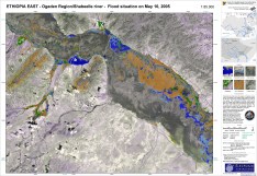
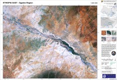
Satellite map of Ethiopia, Ogaden region. Flooded areas and potentially flooded areas
Copyright: CNES 2005, distributed by Spot Image VMap0 National Imagery and Mapping Agency (NIMA) 2000 DEM DLR 2005 Image processing and map creation DLR
Information about the Product
Acquired: 10/05/2005
Source: SPOT

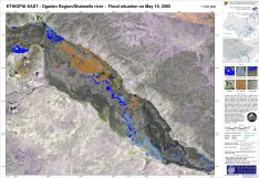
Ogaden/Shabeelle (1:100.000).
Copyright: SPOT CNES 2005, distributed by Spot Image ENVISAT ASAR ESA 2005 Radarsat CSA 2005, distributed by Radarsat International VMap0 DLR 2005 Image processing and map creation DLR
Information about the Product
Acquired: 10/05/2005
Source: ENVISAT-ASAR, SPOT4, RADARSAT
 Back to the full activation archive

 English
 Spanish
 French
 Chinese
 Russian
 Portuguese


