 English
 Spanish
 French
 Chinese
 Russian
 Portuguese
 Latest Activation
Charter activations
Landslide in Kyrgyzstan
Heavy rainfall affected western Kyrgyzstan triggering floods and landslides that have resulted in casualties and damage. A powerful mudflow hit Jenish village, Kadamjay district, Batken region carrying away a cargo container, numerous cars and blocking the Osh-Batken-Razzakov road.
The Ministry of Emergency Situations has deployed about 300 personel and more than 40 pieces of special equipment to eliminate the consequences of the debris flows.
Related Resources:
| Type of Event: | Landslide |
| Location of Event: | Kyrgyzstan |
| Date of Charter Activation: | 2024-06-25 |
| Time of Charter Activation: | 23:50 |
| Time zone of Charter Activation: | UTC+09:00 |
| Charter Requestor: | ADRC on behalf of CAIAG |
| Activation ID: | 889 |
| Project Management: | Syams Nashrrullah (AIT) |
| Value Adding: | Thanaphol Boodchuang (Asian Institute of Technology (AIT)) victor Navarro (ABAE) Camila Gonçalves dos Santos (UFRRJ) Mohammed Bin Rashid Space Centre |
Products
Mudflow in Osh City, Kyrgyzstan
Copyright: Includes Pleiades material © CNES (2024), Distribution Airbus DS.
GeoEye-1 © 2004 GeoEye NextView License
WorldView-2 © (2024) DigitalGlobe, Inc., Longmont CO USA 80503. DigitalGlobe and the DigitalGlobe logos are trademarks of DigitalGlobe, Inc. The use and/or dissemination of this data and/or of any product in any way derived there from are restricted. Unauthorized use and/or dissemination is prohibited.
Map produced by GIC-AIT
Information about the Product
Acquired: Pleiades: 18/07/2024
GeoEye-1: 02/06/2024
WorldView-2: 08/06/2024
Source: Pleiades / GeoEye-1 / WorldView-2
Category: Delineation Map
Mudflow in Nookat district, Osh region, Kyrgyzstan
Copyright: © (2024) DigitalGlobe, Inc., Longmont CO USA 80503. DigitalGlobe and the DigitalGlobe logos are trademarks of DigitalGlobe, Inc. The use and/or dissemination of this data and/or of any product in any way derived there from are restricted. Unauthorized use and/or dissemination is prohibited.
Map produced by GIC-AIT
Information about the Product
Acquired: 03/07/2024
Source: WorldView-3
Category: Delineation Map
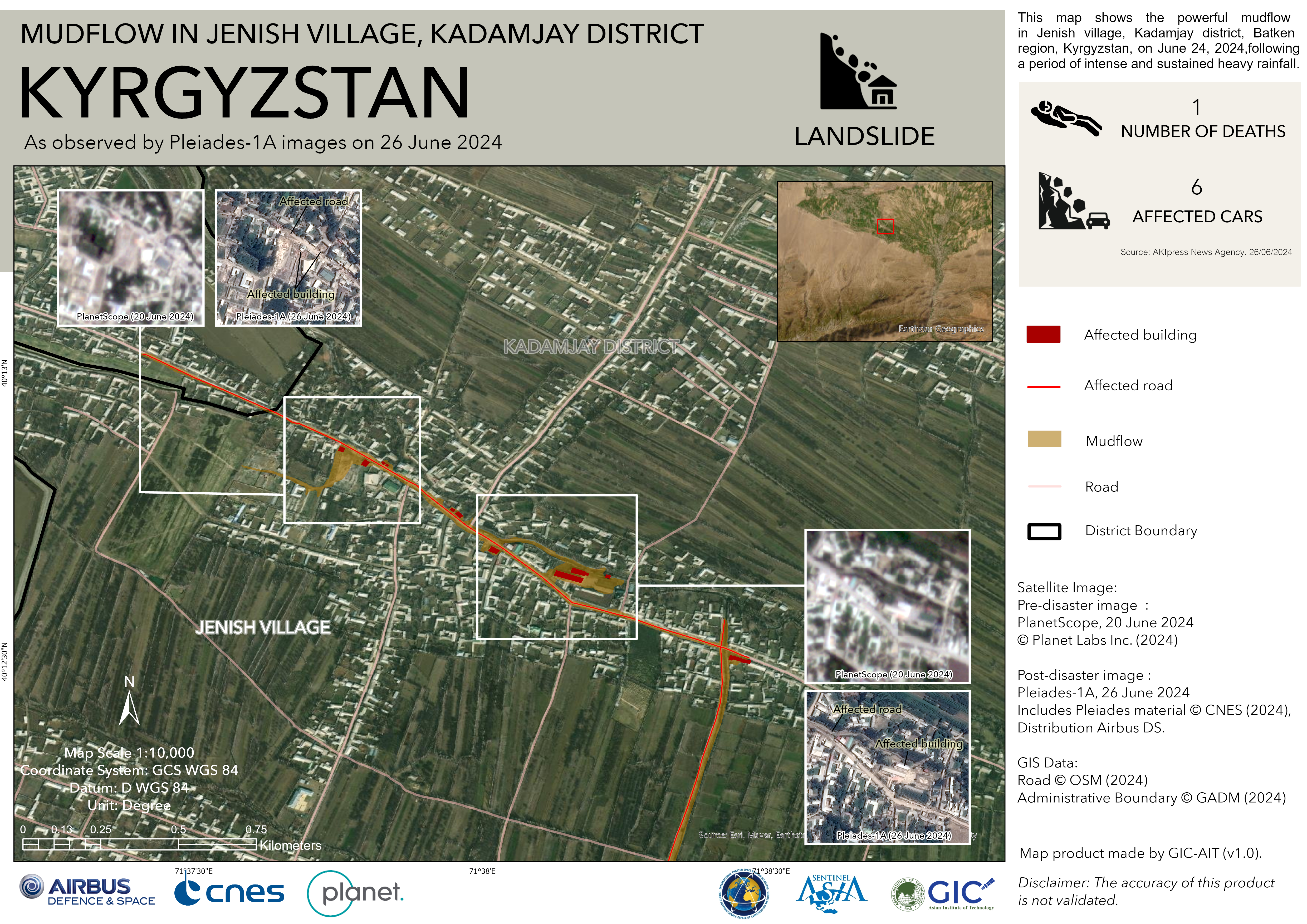
Mudflow in Jenish Village, Kadamjay District, Kyrgyzstan
Copyright: © Planet Labs Inc. (2024)
Includes Pleiades material © CNES (2024), Distribution Airbus DS.
Map produced by GIC-AIT
Information about the Product
Acquired: Pleiades: 26/06/2024, PlanetScope: 20/06/2024
Source: PlanetScope / Pleiades
Category: Delineation Map
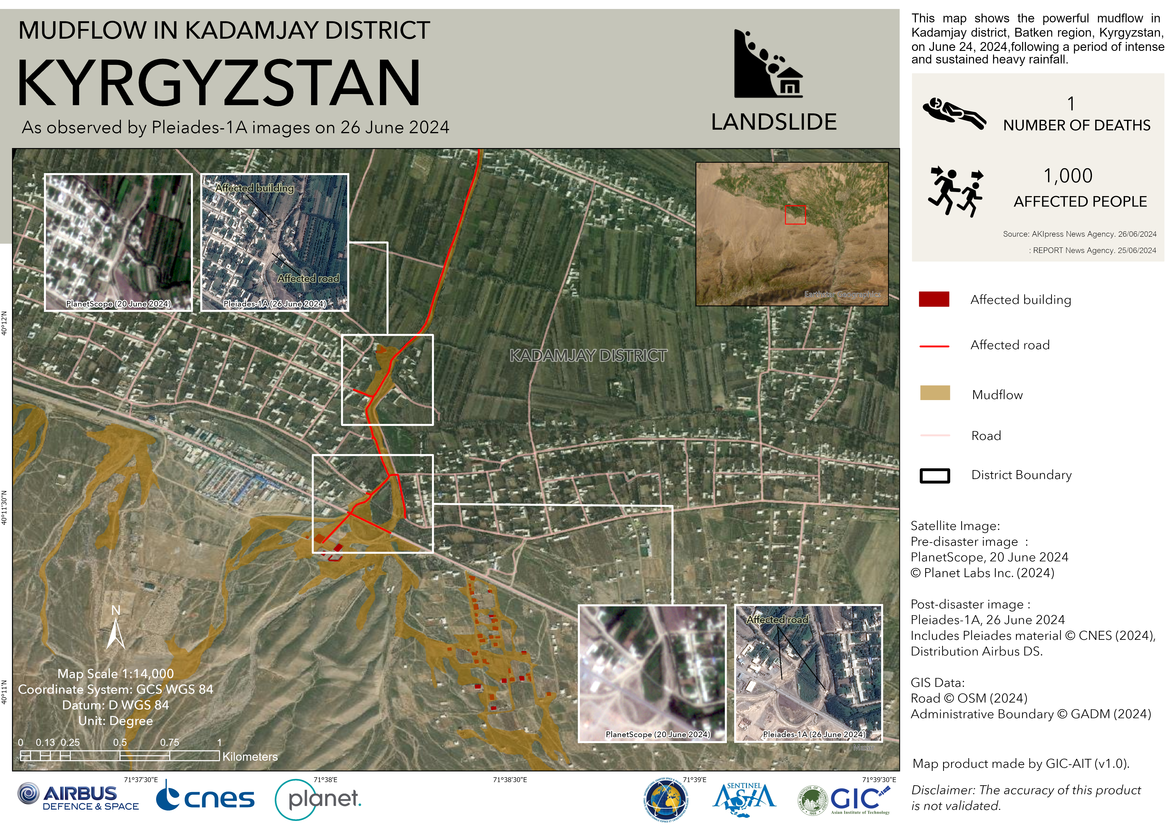
Mudflow in Kadamjay District, Kyrgyzstan
Copyright: Includes Pleiades material © CNES (2024), Distribution Airbus DS.
© Planet Labs Inc. (2024)
Map produced by GIC-AIT
Information about the Product
Acquired: Pleiades: 26/06/2024
PlanetScope: 20/06/2024
Source: Pleiades / PlanetScope
Category: Delineation Map
 Back to the full activation archive

