Charter activations
Hurricane Karl, Mexico
Last week, Hurricane Karl hit the coast of Veracruz state as a Category Three hurricane, leaving 18 dead, more than 40,000 displaced by the flooding of rivers and ditches, an undetermined number missing and thousands displaced across Veracruz, Tabasco, Chiapas, Oaxaca, Puebla, Tlaxcala, Nuevo Leon and Tamaulipas.
| Type of Event: | Hurricane, Flood |
| Location of Event: | Mexico |
| Date of Charter Activation: | 22 September 2010 |
| Charter Requestor: | USGS on behalf of Mexico National Center for Disaster Protection |
| Project Management: | USGS |
Products

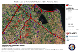
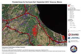
Flooded areas for Hurricane Karl
September 2010
Veracruz, Mexico
Copyright: JAXA, ESA (2010)
RADARSAT-1 Data and Products © MacDonald, Dettwiler and Associates Ltd. (2010) - All Rights Reserved. RADARSAT is an official trademark of the Canadian Space Agency.
Map produced by CENAPRED
Information about the Product
Acquired: September 2010
Source: PALSAR, RADARSAT-1, Envisat
 Back to the full activation archive

 English
 Spanish
 French
 Chinese
 Russian
 Portuguese


