Charter activations
Cyclone in Madagascar
Cyclone Indiala made landfall on the northeastern coast of Madagascar with winds of more than 230 km/h on 15 March. After moving inland, torrential rain and high winds up to 125 kilometres per hour continued to cause severe damage. By 23 March relief organisations and Madagascan authorities reported between 75,000 and 225,000 affected by flooding and landslides, with an estimated 15,000 left homeless in the districts of Diana, Sava, Sofia and Analajirofo (towns of Maroantsetra, Antalaga, Ananalava, Ambanja). The rice and vanilla crops were seriously damaged.
| Type of Event: | Cyclone |
| Location of Event: | Madagascar |
| Date of Charter Activation: | 23/03/2007 18:43 UTC |
| Charter Requestor: | UNOOSA on behalf of UNDP |
| Project Management: | UNOSAT |
Products

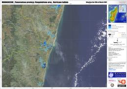
Tropical cyclone Indiala, Vangaindrano 28/03/2007 Scale 1:200,000
Copyright: CSA 2000-2007, USGS 2001 in the framework of GMES RESPOND
Information about the Product
Acquired: 28/03/2007 Flood extent derived from Radarsat-1 satellite imagery (23 March 2000 and 28 March 2007) over natural colour mosaic of Landsat 7 ETM+ images, acquired in April 2001 and September 2001.
Source: RADARSAT-1, Landsat-7 ETM+, resolution 12.5m.

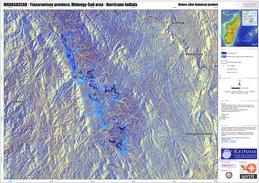
Tropical cyclone Indiala, Midongy 28/03/2007 Scale 1:75,000
Copyright: CSA 2000-2007, USGS 2001 in the framework of GMES RESPOND
Information about the Product
Acquired: 28/03/2007 Flood space map 28 March 2007, Radarsat-1 satellite imagery; colour composition of archived (23 March 2000) and post-cyclone (28 March 2007) Radarsat-1 imagery.
Source: RADARSAT-1, Landsat-7 ETM+, resolution 12.5m.

Tropical cyclone Indiala, Farafangana 28/03/2007 Scale 1:200,000
Copyright: CSA 2000-2007, USGS 2001 in the framework of GMES RESPOND
Information about the Product
Acquired: 28/03/2007 Landsat-7 mosaic background image, Radarsat-1 standard mode 23-28 March 2007, showing flood extent
Source: RADARSAT-1, Landsat-7 ETM+, resolution 12.5m.
 Back to the full activation archive

 English
 Spanish
 French
 Chinese
 Russian
 Portuguese


